Documentation Revision Date: 2020-08-28
Dataset Version: 1
Summary
Pre-Delta-X was a joint airborne and field campaign in the MRD beginning Spring 2015 and continuing through Fall 2016. The Pre-Delta-X campaign conducted airborne (remote sensing) observations and field (in situ) measurements to characterize delta hydrology, water quality (e.g., total suspended solids), and vegetation structure. These data facilitate the continued development of sampling methods, algorithms, and models to support the upcoming airborne and field campaigns (2021–2023) in support of the Delta-X mission.
There are four data files with this dataset in comma-separated value (.csv) format.

Figure 1. Collection of surface water samples in the Atchafalaya River for total suspended solids (TSS) analysis.
Citation
Castaneda, E., A.I. Christensen, M. Simard, D.J. Jensen, R. Twilley, and R. Lane. 2020. Pre-Delta-X: Total Suspended Solids of Surface Water across MRD, LA, USA, 2015-2016. ORNL DAAC, Oak Ridge, Tennessee, USA. https://doi.org/10.3334/ORNLDAAC/1802
Table of Contents
- Dataset Overview
- Data Characteristics
- Application and Derivation
- Quality Assessment
- Data Acquisition, Materials, and Methods
- Data Access
- References
Dataset Overview
This dataset contains the total suspended solids (TSS) concentration of in situ water samples collected at selected sites across the Atchafalaya and Terrebonne Basins within the Mississippi River Delta (MRD) floodplain of coastal Louisiana, USA. The measurements were made during the Pre-Delta-X campaign in Spring 2015 and Fall 2016. The sampling sites spanned large and small channels at locations chosen to cover a representative range of suspended sediment concentrations from a variety of hydrodynamic and physical settings typically encountered across the basins. Water samples were collected by bottle just beneath the surface and stored on ice until filtering. TSS concentration was calculated as the difference of the filter weight (before and after filtration) divided by the volume of sample filtered. Both TSS and in situ spectral reflectance measurements were collected at some sampling sites. Pre-Delta-X sampling focused on surface waters, where the TSS data are used as inputs for hydrodynamic models for sediment transport and to calibrate the model to convert AVIRIS-NG spectral reflectance measurements into TSS (Jensen et al., 2019).
Pre-Delta-X was a joint airborne and field campaign in the MRD beginning Spring 2015 and continuing through Fall 2016. The Pre-Delta-X campaign conducted airborne (remote sensing) observations and field (in situ) measurements to characterize delta hydrology, water quality (e.g., total suspended solids), and vegetation structure. These data facilitate the continued development of sampling methods, algorithms, and models to support the upcoming airborne and field campaigns (2021–2023) in support of the Delta-X mission.
Project: Delta-X
The Delta-X mission is a NASA Earth Venture Suborbital-3 mission to study the Mississippi River Delta in the United States, which is growing and sinking in different areas. River deltas and their wetlands are drowning as a result of sea level rise and reduced sediment inputs. The Delta-X mission will determine which parts will survive and continue to grow, and which parts will be lost. Delta-X begins with airborne and in situ data acquisition and carries through data analysis, model integration, and validation to predict the extent and spatial patterns of future deltaic land loss or gain.
Related Datasets
Additional Pre-Delta-X datasets are available on the ORNL DAAC Delta-X project page.
Related Publications
Jensen, D., M. Simard, K. Cavanaugh, Y. Sheng, C.G. Fichot, T. Pavelsky, and R. Twilley. 2019. Improving the Transferability of Suspended Solid Estimation in Wetland and Deltaic Waters with an Empirical Hyperspectral Approach. Remote Sensing, 11(13):1629. https://doi.org/10.3390/rs11131629
Acknowledgments
This work was supported by the Delta-X mission (funded under the NASA Earth Venture Suborbital-3 program), Caltech/JPL President Director's Fund, and Jet Propulsion Laboratory Strategic Research and Technology Development (JPL-R&TD) FY17–19.
Data Characteristics
Spatial Coverage: Atchafalaya and Terrebonne Basins, Mississippi River Delta (MRD) floodplain, southern coast of Louisiana, USA
Spatial Resolution: Points
Temporal Coverage: 2015-05-06 to 2016-10-21
Temporal Resolution: One-time measurement
Site Boundaries: Latitude and longitude are given in decimal degrees.
| Site | Westernmost Longitude | Easternmost Longitude | Northernmost Latitude | Southernmost Latitude |
|---|---|---|---|---|
| Atchafalaya and Terrebonne Basins | -91.5024 | -90.6776 | 29.744005 | 29.221693 |
Data File Information
There are four data files in comma-separated value (.csv) format; two files for measurements collected during the Spring 2015 and two files for measurements collected during Fall 2016. The files are named PreDeltaX_TotalSuspSolids_Y_Z.csv, where Y is Atchafalaya or Terrebonne and Z is Spring2015 or Fall2016.
Table 1. Variable names and descriptions.
| Variable | Units | Description |
|---|---|---|
| basin | Atchafalaya or Terrebonne | |
| site_id | Location within the basins; each sampling site was named using one of the abbreviations in Table 2 and a sequential number indicating its order of collection | |
| campaign | Spring_2015 or Fall_2016 | |
| latitude | decimal degrees | Latitude of site |
| longitude | decimal degrees | Longitude of site |
| date | YYYY-MM-DD | Date of sampling in UTC |
| time | hh:mm | Time of sampling in UTC; time values provided for the Fall 2016 campaigns only; columns included for Spring 2015 campaigns for consistency; missing values are indicated by -9999 |
| volume_filtered | mL | Total volume of water in milliliters collected and filtered; values provided for the Spring 2015 campaigns only; columns included for Fall 2016 campaigns for consistency; missing values are denoted by -9999 |
| tss | mg/L | Total suspended solids concentration in milligrams per liter; calculated as dried particle weight divided by volume filtered |
Application and Derivation
Measuring total suspended solids (TSS), which describes the amount of organic and inorganic suspended particles in a water column, provides critical information to assess the causes of wetland dynamics, as changes in supply may help explain wetland submergence (Jensen et al., 2019). For this dataset, the in situ sampling locations spanned large and small channels at locations chosen to cover a representative range of suspended sediment concentrations from a variety of hydrodynamic and physical settings typically encountered across the basins. The data will be useful in future modeling efforts.
Quality Assessment
Only a subsample of each 1 L bottle was used in the analysis; enough to ensure sufficient collection of particulates on the filter. Therefore, data quality was ensured by using volumetric cylinders for accurate volume measurements and analyzing replicates every 5-10 samples.
Data Acquisition, Materials, and Methods
Study Area
The study area was the Atchafalaya and Terrebonne Basins on the southern coast of Louisiana within the Mississippi River Delta (MRD) floodplain (Figure 2). The Mississippi Delta formed as a series of overlapping lobes over the past 6000–7000 years and consists of two physiographic units, the Deltaic plain to the east and Chenier plain to the west. The deltaic plain contains the Atchafalaya River, a major distributary of the Mississippi River that dominates the study site and terminates at the Wax Lake and Atchafalaya Deltas (Roberts, 1997). These deltas receive water and sediment discharge from the Atchafalaya River, which is maintained at 30% of the combined discharge of the Mississippi and Red Rivers. April is considered the early phase of the vegetation growing season and the peak of the spring river flood season. Several of the selected sites for field measurements are part of the Coastal Reference Monitoring System (CRMS; Steyer et al., 2003).
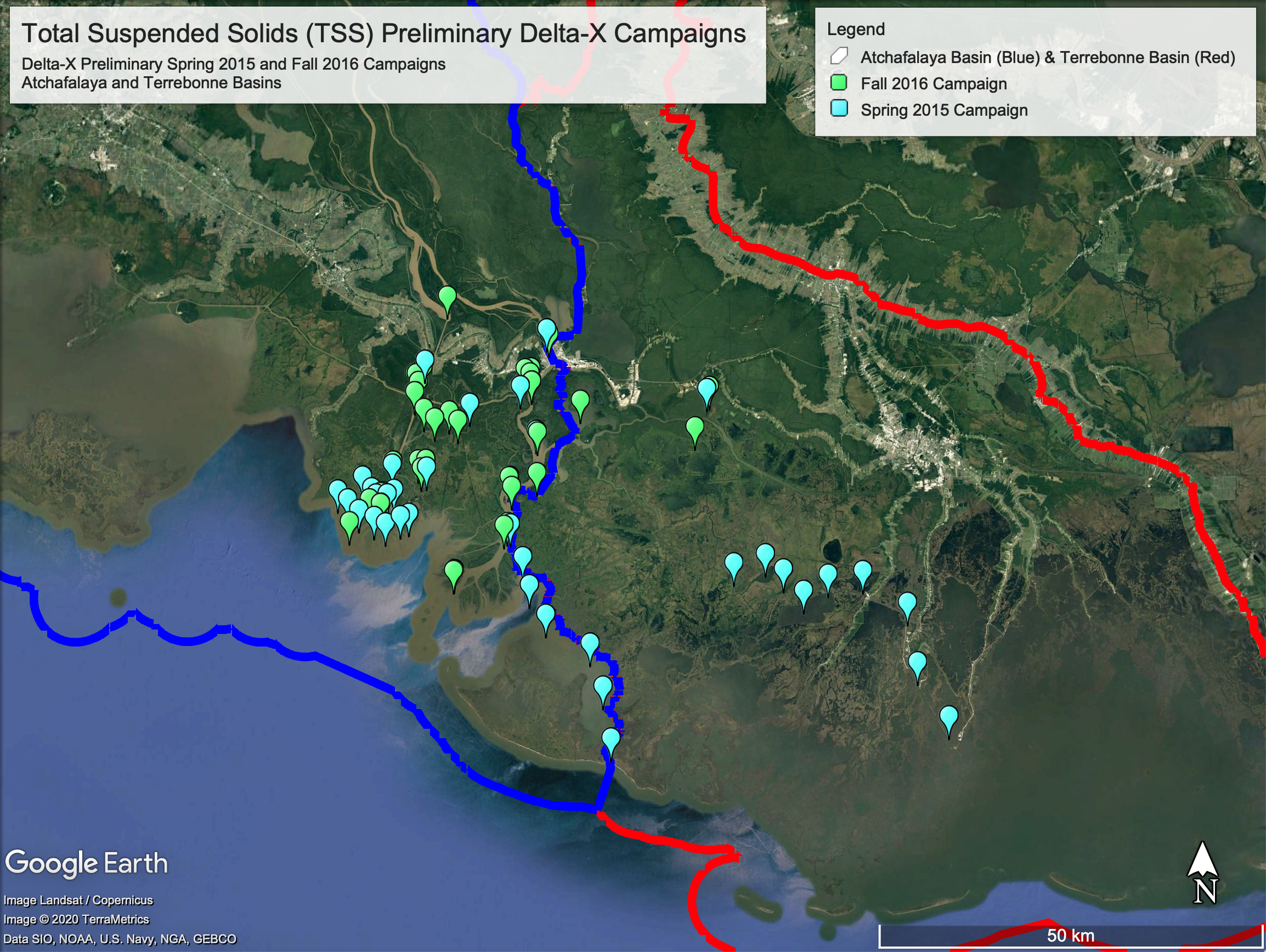
Figure 2. TSS study sites for Spring 2015 and Fall 2016 Pre-Delta-X campaign. The blue border shows the reference boundaries between the Atchafalaya and Terrebonne basins. Intensive sites, where both TSS and in situ remote sensing measurements were collected, have the prefix “IS”.
Study Sites
Each sampling site was named using one of the abbreviations in Table 2, and a sequential number indicating its order of collection. Although each is a distinct measurement, if measurements were collected in very close proximity to each other, the assigned site name is the same (e.g., IS_Atch_1). There may be an overlap in the numbering and site name abbreviations used across the two campaigns, but the sites from Spring 2015 and Fall 2016 were not planned to correspond (Figure 2).
At some sites, both TSS and in situ spectral reflectance (another Pre-Delta-X dataset) were collected (Jensen et al., 2019). These sites, where more than one type of field measurement was collected, are referred to as "intensive sites" and are denoted by the prefix “IS” in the variable site_id.
Table 2. Site names and abbreviations
| Abbreviated Site Name | Full Site Name |
|---|---|
| Atch | Atchafalaya |
| WLD | Wax Lake Delta |
| WICWW | Wax Lake Intracoastal Waterway |
| AICWW | Atchafalaya Intracoastal Waterway |
| L | Lumcon or Louisiana Universities Marine Consortium |
| CRMS | Coastwide Reference Monitoring System |
| JPL | Jet Propulsion Laboratory |
| M | St Mary Parish |
Sampling Procedure
Each in situ water sample was collected directly from the boat by submerging a 1 L amber sample bottle just beneath the surface (Figure 1). For the Spring 2015 and Fall 2016 campaigns, there was a specific interest in surface water, and samples were not collected at specific depths. Bottles were rinsed with site water before collecting the sample. Samples were stored on ice throughout the day, returned to Louisiana State University Wetland Biogeochemistry Analytical Services Lab, and processed according to the ESS Method 340.2 (EPA 1993; Jensen et al., 2019). The samples were vacuum filtered through a pre-weighed, pre-combusted 0.7 micron GF/F filter and rinsed to remove salts. After filtration, the sample collected on the filter was dried at 110°C. The TSS concentration was calculated as the difference of the filter weight (before and after filtration), which represents the weight of suspended sediment collected on the filter, divided by the volume filtered, reported in mg L-1.
Data Access
These data are available through the Oak Ridge National Laboratory (ORNL) Distributed Active Archive Center (DAAC).
Pre-Delta-X: Total Suspended Solids of Surface Water across MRD, LA, USA, 2015-2016
Contact for Data Center Access Information:
- E-mail: uso@daac.ornl.gov
- Telephone: +1 (865) 241-3952
References
EPA, Environmental Protection Agency. ESS Method 340.2: Total Suspended Solids, Mass Balance (Dried at 103-105 degrees C) Volatile Suspended Solids (Ignited at 550 degrees C). Environmental Protection Agency, Environmental Sciences Section: Madison, WI, USA, 1993.
Jensen, D., M. Simard, K. Cavanaugh, Y. Sheng, C.G. Fichot, T. Pavelsky, and R. Twilley. 2019. Improving the Transferability of Suspended Solid Estimation in Wetland and Deltaic Waters with an Empirical Hyperspectral Approach. Remote Sensing, 11(13):1629. https://doi.org/10.3390/rs11131629
Roberts, H.H. 1997. Dynamic changes of the Holocene Mississippi River delta plain: The delta cycle. Journal of Coastal Research, 605–627. https://www.jstor.org/stable/4298659
Steyer, G.D., C.E. Sasser, J.M. Visser, E.M. Swenson, J.A. Nyman, and R.C. Raynie. 2003. A proposed coast-wide reference monitoring system for evaluating wetland restoration trajectories in Louisiana. Environmental Monitoring and Assessment, 81(1/3):107–117. https://doi.org/10.1023/A:1021368722681