Documentation Revision Date: 2020-08-26
Dataset Version: 1
Summary
Pre-Delta-X was a joint airborne and field campaign in the MRD beginning Spring 2015 and continuing through Fall 2016. The Pre-Delta-X campaign conducted airborne (remote sensing) observations and field (in situ) measurements to characterize delta hydrology, water quality (e.g., total suspended solids), and vegetation structure. These data facilitate the continued development of sampling methods, algorithms, and models to support the upcoming airborne and field campaigns in support of the Delta-X mission.
In this dataset, there are five files in comma-separated value (.csv) and one file in GeoTIFF (.tif) format.

Figure 1. This figure shows in blue the extent of the Fall 2016 channel bathymetry survey in the main channels of the Atchafalaya and Wax Lake Deltas.
Citation
Denbina, M.W., M. Simard, T.M. Pavelsky, A.I. Christensen, K. Liu, and C. Lyon. 2020. Pre-Delta-X: Channel Bathymetry of the Atchafalaya Basin, LA, USA, 2016. ORNL DAAC, Oak Ridge, Tennessee, USA. https://doi.org/10.3334/ORNLDAAC/1807
Table of Contents
- Dataset Overview
- Data Characteristics
- Application and Derivation
- Quality Assessment
- Data Acquisition, Materials, and Methods
- Data Access
- References
Dataset Overview
This dataset provides water depths and water surface elevations collected during bathymetric surveys of the main channel of the Wax Lake Delta within the Mississippi River Delta (MRD) floodplain of coastal Louisiana, USA. The measurements were made during the Pre-Delta-X Campaign in Fall 2016. The in situ continuous (1 Hz) surveys of channel bathymetry were conducted using a SonarMite Hydrolite Single Beam Echo Sounder mounted on the side of the research boat. The sounder was located directly beneath the Septentrio global navigation satellite system (GNSS) antenna, about 30 cm below the water surface. The sounder depth observations were integrated with the GNSS location and elevation data into one data file per day for October 16-20. These bathymetry measurements were used to generate a merged digital elevation model (DEM) through interpolation with ancillary DEMs (e.g. Gesch et al. 2002 and Shaw et al. 2016) to expand the existing wetland DEM to include channels. The merged DEM product is distributed in GeoTIFF format.
Pre-Delta-X was a joint airborne and field campaign in the MRD beginning Spring 2015 and continuing through Fall 2016. The Pre-Delta-X campaign conducted airborne (remote sensing) observations and field (in situ) measurements to characterize delta hydrology, water quality (e.g., total suspended solids), and vegetation structure. These data facilitate the continued development of sampling methods, algorithms, and models to support the upcoming airborne and field campaigns in support of the Delta-X mission.
Project: Delta-X
The Delta-X mission is a NASA Earth Venture Suborbital-3 mission to study the Mississippi River Delta in the United States, which is growing and sinking in different areas. River deltas and their wetlands are drowning as a result of sea level rise and reduced sediment inputs. The Delta-X mission will determine which parts will survive and continue to grow, and which parts will be lost. Delta-X begins with airborne and in situ data acquisition and carries through data analysis, model integration, and validation to predict the extent and spatial patterns of future deltaic land loss or gain.
Related Datasets
Additional Pre-Delta-X datasets are available on the ORNL DAAC Delta-X project page.
Acknowledgments
This work was supported by the Delta-X mission, funded under the NASA Earth Venture Suborbital-3 (EVS-3) program, and JPL Research and Technology Development Strategic R&TD FY17-19
Data Characteristics
Spatial Coverage: Wax Lake Delta within the Mississippi River Delta (MRD) floodplain, southern coast of Louisiana, USA.
Spatial Resolution: Points
Temporal Coverage: 2016-10-16 to 2016-10-20
Temporal Resolution: One-time measurements
Site Boundaries: Latitude and longitude are given in decimal degrees.
| Site | Westernmost Longitude | Easternmost Longitude | Northernmost Latitude | Southernmost Latitude |
|---|---|---|---|---|
| Atchafalaya Basin | -91.90775 | -90.35938 | 29.95798 | 28.97765 |
Data File Information
There are five files in comma-separated value (.csv) containing daily bathymetry data and one file in GeoTIFF (.tif) format the merged DEM product. The files are named PreDeltaX_ChannelBathymetry_Atchafalaya_YYYYMMDD.csv where YYYMMDD is the date of data collection and PreDeltaX_MultiSource_Bathymetry_DEM_Atchafalaya_Basin_Fall2016.tif.
Table 1. Variable names and descriptions in PreDeltaX_ChannelBathymetry_Atchafalaya_YYYYMMDD.csv
| Variable* | Units | Description |
|---|---|---|
| basin | Atchafalaya | |
| obs_time | YYYY-MM-DD hh:mm:ss | UTC observation time from sounder |
| obs_freq | Hz | 1 hertz; frequency of data collection |
| longitude | decimal degrees | Longitude of GNSS antenna |
| latitude | decimal degrees | Latitude of GNSS antenna |
| water_depth | m | Corrected water depth in meters |
| water_surface_elevation | m | Corrected water surface elevation in meters |
Table 2. Variable names and descriptions in PreDeltaX_MultiSource_Bathymetry_DEM_Atchafalaya_Basin_Fall2016.tif
| Variable** | Units | Description |
|---|---|---|
| elevation | m | Interpolated channel bathymetry in meters |
Application and Derivation
The sonar-derived water depth data were used to expand the existing wetland DEM to channels. The merged DEM is used as the input to hydrodynamic and sediment transport modeling.
Quality Assessment
Recorded depths of 0 m occur when the sounder comes out of the water in rough conditions, the water depth is too shallow, or when the boat is moving at too high a speed. Therefore, 0 m depth observations were flagged in the vector product and removed from analysis in the raster product. In the future Delta-X research, uncertainties in the XYZ position and quality notes might be included in the data products.
Data Acquisition, Materials, and Methods
Study Area
The study area was the Atchafalaya and Terrebonne Basins on the southern coast of Louisiana within the Mississippi River Delta (MRD) floodplain (Figure 2). The Mississippi Delta formed as a series of overlapping lobes over the past 6000–7000 years and consists of two physiographic units, the Deltaic plain to the east and Chenier plain to the west. The deltaic plain contains the Atchafalaya River, a major distributary of the Mississippi River that dominates the study site and which terminates at the Wax Lake and Atchafalaya Deltas (Roberts, 1997). These deltas receive water and sediment discharge from the Atchafalaya River, which is maintained at 30% of the combined discharge of the Mississippi and Red Rivers. April is considered the early phase of the vegetation growing season and the peak of the spring river flood season. Several of the selected sites for field measurements are part of the Coastal Reference Monitoring System (CRMS, Steyer et al. 2003).
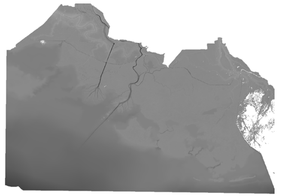
Figure 2. The collected bathymetry measurements were combined through interpolation with ancillary data to derive a merged DEM for the larger delta study area. Source: PreDeltaX_MultiSource_Bathymetry_DEM_Atchafalaya_Basin_Fall2016.tif
Channel Surveys
Continuous surveys of channel bathymetry were conducted using a SonarMite Hydrolite Single Beam Echo Sounder (Ohmex Ltd, 2018). The sounder was mounted on the stern or side of the research vessel at approximately 30 cm depth below the water surface, directly beneath the Septentrio global navigation satellite system (GNSS) antenna. The echo sounder remained in data collection mode whenever the research vessel was operational and multi- and single-beam bathymetry surveys were completed in the main channel of the Wax Lake Delta. High-density bathymetry data were collected by surveying the channel in a zigzag pattern along the axes of the channel. All bathymetry data were collected at 1 Hz using the SonarMite+ application for Android that was exported to a portable hard drive and field computer at the end of each field day.
To process bathymetry from sonar records, the sonar at a given time was matched to the GPS at that same time and used to estimate position. Sounder depth observations were integrated with manually measured depths of the sounder below the water surface to get corrected water depths. Once the boat-mounted GNSS data was post-processed to Precise Point Positioning (PPP), 1 Hz GNSS observations (latitude, longitude, and water surface elevation) were matched to the depth sounder data by time. This resulted in one file per day of echo sounder observations.
SonarMite Hydrolite Echo Sounder Measurement Quality Control
At the beginning of each field day, the clock on the phone used to control the echo sounder was synced to the clock on the boat-mounted GNSS receiver. The depth of the bottom of the sounder below the water surface was recorded at the beginning and the end of each field day as well as when there were any significant shifts in how the research vessel is weighted in the water (e.g., when the number of people aboard the vessel changes or large equipment is rearranged).
The depth range of the sounder was 0.30 m to 75 m (Ohmex Ltd, 2018). Therefore, shallow areas of the channel were often lacking in observations and the depths in these shallow areas may be positively biased in this raster product. At key locations, the topographic model was cross-checked against and corrected to match channel cross-sections derived from the SonTek M9 ADCP dataset (Christensen, et al., 2020, Oberg et al., 2015)
Integrated Multi-Source DEM and Bathymetry Product
The sonar raster GeoTIFF product is composed of merged DEM and bathymetry elevations in the NAVD88 vertical datum (Figure 2). The Pre-Delta-X sonar bathymetry measurements were converted into a 2D raster product that used interpolation to transform irregularly spaced bathymetric data into a raster grid. Then the final sonar raster was generated by merging a weighted average of the Pre-Delta-X sonar bathymetry 2D raster with other data sources: USGS National Elevation Dataset (NED; Gesch et al. , 2002) which was used as a DEM over land areas only; Shaw et. al (2016) bathymetry used in areas of the Wax Lake Delta without sonar data coverage from Delta-X surveys; bathymetry sourced from publicly available data for places where bathymetry was not available from other sources (Xing et al., 2017); and synthetic bathymetry calculated as a multiple of the river channel width. The fraction of total weights for each component of the merged product was determined by a mixture of parameters such as area, distance from land or water, distance from nearest bathymetry sample in the case of interpolated data, etc.
Data Access
These data are available through the Oak Ridge National Laboratory (ORNL) Distributed Active Archive Center (DAAC).
Pre-Delta-X: Channel Bathymetry of the Atchafalaya Basin, LA, USA, 2016
Contact for Data Center Access Information:
- E-mail: uso@daac.ornl.gov
- Telephone: +1 (865) 241-3952
References
Christensen, A.I., T.M. Pavelsky, D.J. Jensen, and K. Liu. 2020. Pre-Delta-X: River Discharge Channel Surveys across Atchafalaya Basin, LA, USA, 2016. ORNL DAAC, Oak Ridge, Tennessee, USA. https://doi.org/10.3334/ORNLDAAC/1806
Gesch, D., M. Oimoen, S. Greenlee, C. Nelson, M. Steuck, and D. Tyler (2002), The National Elevation Dataset, Photogramm. Eng. Remote Sens., 68, 5 – 11.
Oberg, K.A., Morlock, S.E., & Caldwell, W.S. (2015). Quality-assurance plan for discharge measurements using acoustic doppler current profiles. U.S. Geological Survey Scientific Investigations Report 2005-5183. Retrieved June 25, 2019 from https://pubs.usgs.gov/sir/2005/5183/index_toc.html.
Ohmex Ltd. 2018. SonarMite V5 Echo Sounder.
Roberts, H.H. 1997. Dynamic changes of the Holocene Mississippi River delta plain: The delta cycle. Journal of Coastal Research, 605–627. https://www.jstor.org/stable/4298659
Shaw, J.B., F. Ayoub, C.E. Jones, M.P. Lamb, B. Holt, R.W. Wagner, T.S. Coffey, J.A. Chadwick, and D. Mohrig. 2016. Airborne Radar Imaging of Subaqueous Channel Evolution in Wax Lake Delta, Louisiana, USA. Geophysical Research Letters, 43(10):5035–42. https://doi.org/10.1002/2016GL068770
Steyer, G.D., C.E. Sasser, J.M. Visser, E.M. Swenson, J.A. Nyman, and R.C. Raynie. 2003. A proposed coast-wide reference monitoring system for evaluating wetland restoration trajectories in Louisiana. Environmental Monitoring and Assessment, 81(1/3):107–117. https://doi.org/10.1023/A:1021368722681
Xing, F., J.P.M. Syvitski, A.J. Kettner, E.A. Meselhe, J.H. Atkinson, and A.K. Khadka. 2017. Morphological responses of the Wax Lake Delta, Louisiana, to Hurricanes Rita. Elem Sci Anth, 5, p.80. DOI: http://doi.org/10.1525/elementa.125