Documentation Revision Date: 2021-04-03
Dataset Version: 1
Summary
Water surface elevation profiles were first calculated as the moving average of the lidar points height coordinates along each water channel. Then a height correction was derived and applied using absolute water level elevations from an in situ reference site (i.e., USGS Calumet Station) and the overlapping ASO lidar flight lines. The corrected results, as provided in this dataset, are time-specific water level elevations in meters with respect to the NAVD 88 geoid and the WGS 84 ellipsoidal surface along the water channels. Uncertainty for each profile estimate was derived from variation among water levels measured by in situ water gauges and the cluster of lidar heights within the analysis window. The standard deviations of the normally distributed errors are provided as a measurement of uncertainty.
Pre-Delta-X was a joint airborne and field campaign in the Mississippi River Delta beginning Spring 2015 and continuing through Fall 2016. The Pre-Delta-X campaign conducted airborne remote sensing observations and field in situ measurements to characterize delta hydrology, water quality (e.g., TSS), and vegetation structure. These data facilitate the continued development of sampling methods, algorithms, and models to support the upcoming airborne and field campaigns (2021-2023) in support of the Delta-X mission.
This dataset consists of a single file in comma-separated value (*.csv) format that provides water level elevation estimates for point locations. A companion file with an overview of the water level gauge and ASO lidar water level profile absolute height corrections, calibration, and uncertainty estimation is also provided.
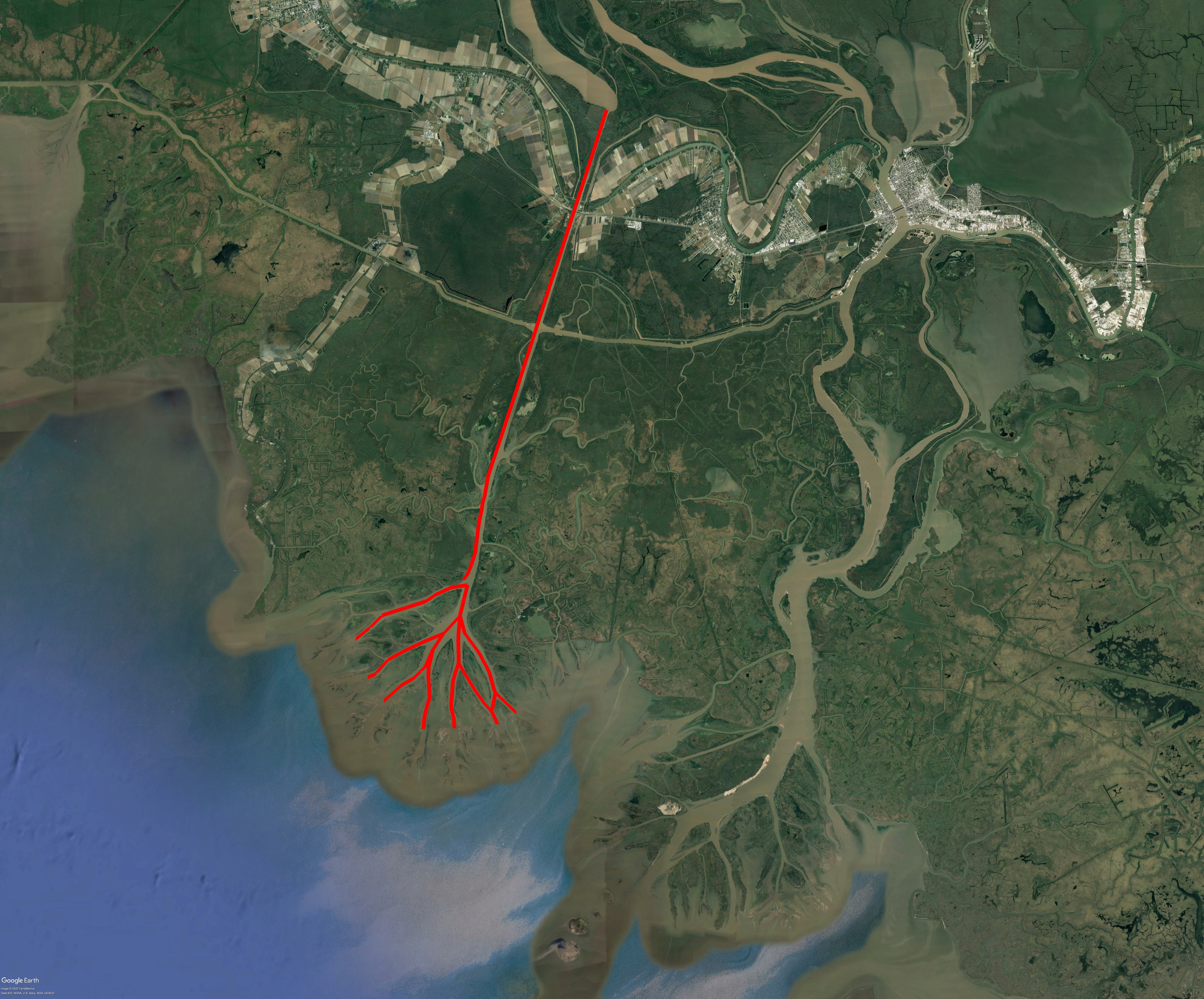
Figure 1. Channels (red) where water level elevation profiles were measured with the Airborne Snow Observatory (ASO) lidar instrument in October 2016. These locations are part of the Atchafalaya basin of the Mississippi River Delta.
Citation
Denbina, M.W., M. Simard, and J. Lai. 2021. Pre-Delta-X: Lidar-derived Water Level Profiles in the Wax Lake Outlet, LA, USA, 2016. ORNL DAAC, Oak Ridge, Tennessee, USA. https://doi.org/10.3334/ORNLDAAC/1820
Table of Contents
- Dataset Overview
- Data Characteristics
- Application and Derivation
- Quality Assessment
- Data Acquisition, Materials, and Methods
- Data Access
- References
Dataset Overview
This dataset contains lidar-derived water surface elevation profiles for river channels between Wax Lake, in the Atchafalaya River Basin of the Mississippi River Delta, and the Gulf of Mexico. The provided elevation profiles (i.e., water levels) were estimated using remotely sensed lidar data in combination with in situ field measurements of water levels for elevation calibration and to quantify uncertainty in estimates. The lidar data were collected during the Fall 2016 Pre-Delta-X Campaign using an Airborne Snow Observatory (ASO) lidar instrument. The results are time-specific water levels measured as elevation in meters with respect to the North American Vertical Datum 1988 (NAVD 88) geoid (or orthometric height) and the World Geodetic System 1984 (WGS 84) ellipsoidal surface (or ellipsoidal/GPS height) along the water channels in this drainage system.
Water surface elevation profiles were first calculated as the moving average of the lidar points height coordinates along each water channel. Next, a height correction was derived and applied using absolute water level elevations from a reference in situ measurement site (i.e., USGS Calumet Station) and the overlapping ASO lidar flight lines. This dataset also includes a measure of water surface elevation profile uncertainty as an estimated standard deviation for each profile sample, where uncertainty was estimated assuming Gaussian-distributed height errors, based on the variance of overlapping in situ water level gauge offsets and the lidar height.
Pre-Delta-X was a joint airborne and field campaign in the Mississippi River Delta beginning Spring 2015 and continuing through Fall 2016. The Pre-Delta-X campaign conducted airborne remote sensing observations and field in situ measurements to characterize delta hydrology, water quality (e.g., TSS), and vegetation structure. These data facilitate the continued development of sampling methods, algorithms, and models to support the upcoming airborne and field campaigns (2021-2023) in support of the Delta-X mission.
Project: Delta-X
The Delta-X mission is a 5-year NASA Earth Venture Suborbital-3 mission to study the Mississippi River Delta in the United States, which is growing and sinking in different areas. River deltas and their wetlands are drowning as a result of sea level rise and reduced sediment inputs. The Delta-X mission will determine which parts will survive and continue to grow, and which parts will be lost. Delta-X begins with airborne and in situ data acquisition and carries through data analysis, model integration, and validation to predict the extent and spatial patterns of future deltaic land loss or gain.
Related Publication
Denbina, M., and M. Simard. 2020. Calibration of airborne measurements of water surface elevation in coastal wetlands. In preparation.
Related Datasets
Denbina, M.W., M. Simard, T.M. Pavelsky, A.I. Christensen, K. Liu, and C. Lyon. 2020. Pre-Delta-X: Channel Bathymetry of the Atchafalaya Basin, LA, USA, 2016. ORNL DAAC, Oak Ridge, Tennessee, USA. https://doi.org/10.3334/ORNLDAAC/1807
Simard, M., M.W. Denbina, D.J. Jensen, and R. Lane. 2020. Pre-Delta-X: Water Levels across Wax Lake Outlet, Atchafalaya Basin, LA, USA, 2016. ORNL DAAC, Oak Ridge, Tennessee, USA. https://doi.org/10.3334/ORNLDAAC/1801
Acknowledgment
This work was supported by Research and Technology Development grant from the Jet Propulsion (grant 01STCR / R.17.231.069).
Data Characteristics
Spatial Coverage: Wax Lake and Atchafalaya Deltas, Mississippi River Delta (MRD) floodplain, southern coast of Louisiana, USA
Spatial Resolution: Points
Temporal Coverage: 2016-10-16 to 2016-10-19
Temporal Resolution: Three samples from each of three days
Study Area: Latitude and longitude are given in decimal degrees.
| Site | Westernmost Longitude | Easternmost Longitude | Northernmost Latitude | Southernmost Latitude |
|---|---|---|---|---|
| Atchafalaya Basin | -91.4850 | -91.3571 | 29.743 | 29.479 |
Data File Information
There is one data file in comma-separated value (.csv) format named PreDeltaX_ASO_Lidar_WaterLevel_Atchafalaya_Fall2016.csv. The file provides point-based water level elevation measurements along channels in the Wax Lake Delta in Louisiana.
Data File Details
Table 1. Variable names and descriptions in PreDeltaX_ASO_Lidar_WaterLevel_Atchafalaya_Fall2016.csv.
| Variable | Units | Description |
|---|---|---|
| channel_id | none | String identifying the channel center line over which the water surface elevation was calculated. WLO stands for Wax Lake Outlet and WLD stands for Wax Lake Delta. WLD is followed by a letter and number identifying the branch of the delta. |
| flight_id | none | Number identifying which lidar flight line collected the profile, ordered by number of acquisition. |
| date | YYYY-MM-DD | Date of acquisition |
| time | hh:mm:ss | Time of acquisition (UTC) |
| utc_time | seconds of the day | Acquisition time (UTC) |
| along_channel_distance | meters | Distance along the river channel |
| CoordX | meters | UTM X coordinate, in WGS 84 / UTM Zone 15N projected coordinate reference system (EPSG:32615) |
| CoordY | meters | UTM Y coordinate, in WGS 84 / UTM Zone 15N projected coordinate reference system (EPSG:32615) |
| longitude | decimal degrees | Longitude coordinate in WGS 84 coordinate reference system (EPSG:4326) |
| latitude | decimal degrees | Latitude coordinate in WGS 84 coordinate reference system (EPSG:4326) |
| water_surface_elevation_NAVD88 | meters | Lidar-derived water surface elevation in meters with respect to the NAVD 88 geoid, or orthometric height |
| water_surface_elevation_WGS84 | meters | Lidar-derived water surface elevation in meters with respect to the WGS 84 ellipsoidal surface, or ellipsoidal height, or GPS height |
| water_surface_elevation_uncertainty | meters | Estimate of the standard deviation of lidar-derived Water Surface Elevation, in meters. Based on the standard deviation of the offsets between the lidar and gauge data. Also based on the standard deviation of the Z coordinates of the lidar point used to generate the profile sample, and will therefore vary along a given profile |
Companion File Information
Table 2. Names and descriptions of companion files included with the dataset.
| File Name | Description |
|---|---|
| Wax_Lake_Water_Level_Data_Overview.pdf | Overview of Water Level Gauges and ASO Lidar water level profile absolute height corrections, calibration, and uncertainty estimates |
| PreDeltaX_ASO_Lidar_WaterLevel_Atchafalaya_Fall2016.csvt | Data types of the columns of the CSV file |
Application and Derivation
These data were used to estimate the slope of the river along channels and to assist in estimates of water discharge. The water surface elevation profiles were used to calibrate the absolute water surface elevation of the in situ water level gauges. The calibration method utilizes the observed elevation differences between multiple profiles acquired at different times and the measurements from in situ gauges.
Quality Assessment
The lidar derived water surface elevation profiles include uncertainty in the form of an estimated standard deviation for each profile sample. Uncertainty was estimated assuming Gaussian-distributed height errors based on the variance of the water level gauge offsets and the lidar height.
Data Acquisition, Materials, and Methods
Generating Water Level Profiles
The lidar water surface elevation profiles were generated using LAS files delivered by the Airborne Snow Observatory (ASO) team. The LAS files contained lidar point cloud information with the parameters X, Y, Z, time, intensity, etc. for each lidar return. The ASO is a RIEGL LMS-Q1560 dual-channel lidar instrument, and the two-channel outputs were combined into a single lidar point cloud before processing.
For processing, Wax Lake Delta channel branches were defined by the Delta-X team because no pre-existing channel reference lines were available (Fig. 2). Within the branches, the channel line points were defined by coordinates in the approximate center of the channel. The UTM coordinates of the lidar point cloud were transformed to along-channel (S) and cross-channel (N) coordinates. To exclude areas over land, a land-water mask derived from UAVSAR backscatter data was applied. To refine the mask, manual polygons were drawn using Google Earth and lidar intensity reference data, particularly over the Wax Lake Delta. Lidar returns with X- and Y-coordinates located over land were excluded from processing.
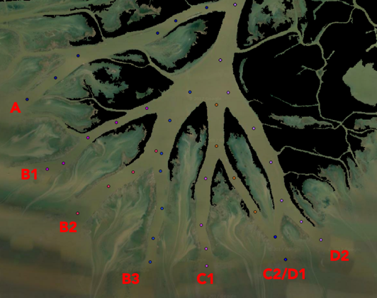
Figure 2. Water channels in Wax Lake delta. Letters denote main branches and numbers denote sub-branches. Areas of land are shown as a black mask.
Lidar Outlier Filtering
From the lidar points that remained after masking, returns with a height outside the bounds of ±5 meters (with respect to the Earth Gravitational Model 1996 (EGM96) geoid) were discarded. A median absolute deviation (MAD) filter was applied to the remaining points, and points with a z-score threshold of 2 (i.e., points with one-sided z-score >2 were removed). The MAD filter is robust to an asymmetrical probability distribution, which is ideal as mostly positive biases were observed owing to water vapor effects. The remaining points were used to calculate the water profile.
Lidar Profile Generation
To calculate profiles of water surface elevation, a moving window was applied along each channel's centerline profile and the moving average of the Z-coordinates of the lidar points within the window dimensions was calculated. For the data in this release, the moving window had a size of 1 km and 50 m between along-channel profile samples.
Bias Correction
The ASO lidar data was originally biased with respect to true water level and the bias varied for different acquisition dates and aircraft altitudes. This bias was likely resultant to a combination of Inertial Measurement Unit/Global Navigation Satellite Systems (IMU/GNSS) errors, potential errors in the intensity-based range correction of the lidar data, and geophysical error sources such as water vapor.
To correct for the bias, an absolute height correction was applied and height correction values were jointly estimated with the Pre-Delta-X in situ water level gauges using an iterative approach (Denbina and Simard, 2020). The USGS Calumet Station (USGS 2016) was used as a reference for absolute water level and overlapping ASO lidar flight lines were corrected with Calumet data. In turn, the corrected lidar flight lines were used to estimate the gauge vs vertical datum offset for water level gauges within the coverage area of the corrected lidar data. Each lidar flight line was corrected using the same bias even when it overlapped with multiple channels and was used to generate multiple profiles. This approach was used to apply the height corrections in a systematic way and because the error sources underlying height bias were expected to be relatively stable within a given flight line. When calculating errors, lidar data were not compared with the gauge used to correct it but instead were compared to other available gauges within its coverage. This approach continued iteratively until all gauges and lidar lines were corrected with estimated offsets. Five lidar flight lines (out of 32) were manually flagged and excluded from the height correction process. These flight lines are not included in this data release.
The companion file Wax_Lake_Water_Level_Data_Overview.pdf provides an overview of the water level gauge and ASO lidar water level profile absolute height corrections, calibration, and uncertainty estimation.
Data Access
These data are available through the Oak Ridge National Laboratory (ORNL) Distributed Active Archive Center (DAAC).
Pre-Delta-X: Lidar-derived Water Level Profiles in the Wax Lake Outlet, LA, USA, 2016
Contact for Data Center Access Information:
- E-mail: uso@daac.ornl.gov
- Telephone: +1 (865) 241-3952
References
Denbina, M., and M. Simard. 2020. Calibration of airborne measurements of water surface elevation in coastal wetlands. In preparation.
USGS. 2016. USGS 07381590 Wax Lake Outlet at Calumet LA. U.S. Geological Survey. https://waterdata.usgs.gov/nwis/uv?site_no=07381590