Documentation Revision Date: 2020-08-25
Dataset Version: 1
Summary
Pre-Delta-X was a joint airborne and field campaign in the MRD beginning Spring 2015 and continuing through Fall 2016. The Pre-Delta-X campaign conducted airborne (remote sensing) observations and field (in situ) measurements to characterize delta hydrology, water quality (e.g., total suspended solids), and vegetation structure. These data facilitate the continued development of sampling methods, algorithms, and models to support the upcoming airborne and field campaigns (2021–2023) in support of the Delta-X mission.
In this dataset, there is one file in comma-separated value (.csv) format and 75 compressed directories (*.zip).
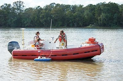
Figure 1. Measurement of river discharge across channels. The acoustic doppler current profiler (ADCP) was mounted on a hydro board, which was allowed to drift alongside the boat while maintaining a transect perpendicular to flow. The impact from the boat was limited by slowly crabbing across each channel, allowing the ADCP to remain on the upstream side of the boat.
Citation
Christensen, A.I., T.M. Pavelsky, D.J. Jensen, and K. Liu. 2020. Pre-Delta-X: River Discharge Channel Surveys across Atchafalaya Basin, LA, USA, 2016. ORNL DAAC, Oak Ridge, Tennessee, USA. https://doi.org/10.3334/ORNLDAAC/1806
Table of Contents
- Dataset Overview
- Data Characteristics
- Application and Derivation
- Quality Assessment
- Data Acquisition, Materials, and Methods
- Data Access
- References
Dataset Overview
This dataset provides river discharge measurements collected at selected locations across the Atchafalaya River Basin, within the Mississippi River Delta (MRD) floodplain in coastal Louisiana, USA. The measurements were made during the Pre-Delta-X campaign on October 15 to 20, 2016. Seventy-five channel surveys were conducted with a SonTek RiverSurveyor M9 acoustic doppler current profiler (ADCP) on selected wide channels (~100 m) and a few selected (~10 m) narrow channels. ADCP data provide near-instantaneous estimates of river discharge across the sampled channels. Sites coincided with AirSWOT swaths in the Atchafalaya River Basin and water level measurement locations. This in situ dataset was used to calibrate and validate Delta-X hydrodynamic models.
Pre-Delta-X was a joint airborne and field campaign in the MRD beginning Spring 2015 and continuing through Fall 2016. The Pre-Delta-X campaign conducted airborne (remote sensing) observations and field (in situ) measurements to characterize delta hydrology, water quality (e.g., total suspended solids), and vegetation structure. These data facilitate the continued development of sampling methods, algorithms, and models to support the upcoming airborne and field campaigns (2021–2023) in support of the Delta-X mission.
Project: Delta-X
The Delta-X mission is a NASA Earth Venture Suborbital-3 mission to study the Mississippi River Delta in the United States, which is growing and sinking in different areas. River deltas and their wetlands are drowning as a result of sea level rise and reduced sediment inputs. The Delta-X mission will determine which parts will survive and continue to grow, and which parts will be lost. Delta-X begins with airborne and in situ data acquisition and carries through data analysis, model integration, and validation to predict the extent and spatial patterns of future deltaic land loss or gain.
Related Datasets
Additional Pre-Delta-X datasets are available on the ORNL DAAC Delta-X project page.
Acknowledgments
This work was supported by the Delta-X mission (funded under the NASA Earth Venture Suborbital-3 program).
Data Characteristics
Spatial Coverage: Atchafalaya Basin, Mississippi River Delta (MRD) floodplain, southern coast of Louisiana, USA
Spatial Resolution: Points
Temporal Coverage: 2016-10-15 to 2016-10-20
Temporal Resolution: One-time measurement
Site Boundaries: Latitude and longitude are given in decimal degrees.
| Site | Westernmost Longitude | Easternmost Longitude | Northernmost Latitude | Southernmost Latitude |
|---|---|---|---|---|
| Atchafalaya Basin | -91.43704 | -91.21236 | 29.74220 | 29.44320 |
Data File Information
This dataset includes one file (*.csv) with summary results for the 75 river discharge profiles and 75 corresponding compressed directories (*.zip) containing RiverSurveyor raw and processed data files. The summary file is named PreDeltaX_RiverDischarge_Atchafalaya_Fall2016.csv. The compressed directories are named RiverSurveyor_YYYYMMDDhhmmss.zip where YYYMMDDhhmmss is the date and time of data collection.
Each row in the summary results provides the respective file name for the compressed directory. Each compressed directory contains seven data files which are described in Table 2.
Data File Details
Table 1. Variable names and descriptions in PreDeltaX_RiverDischarge_Atchafalaya_Fall2016.csv.
| Variable | Units | Description |
|---|---|---|
| Basin | Atchafalaya | |
| campaign | Fall_2016 | |
| transect | integer | Transect number |
| start_edge | Side of the river of transect start | |
| start_latitude | decimal degrees | Latitude of transect start |
| start_longitude | decimal degrees | Longitude of transect start |
| start_time | YYYY-MM-DD hh:mm:ss | Start time of sampling the transect in UTC |
| duration | hh:mm:ss | Duration of transect |
| temperature | °C | Average water temperature along transect |
| track | m | The accumulated total distance the vessel has traveled through the last completed profile. This transect distance reflects zig-zag movement of boat across the channel. |
| dmg | m | Distance from the boat’s last pre-profile position to its present post-profile position; straight line distance from boat position at start of transect to end of transect |
| width | m | Width of the channel |
| percent_measured | % | Percent of the channel width measured during the transect |
| area | m2 | Area of the channel surveyed |
| boat_speed | m/s | Average boat speed during the transect |
| mean_speed | m/s | Average water speed during the transect |
| discharge_left | m3/s | Discharge on the left edge of the transect |
| discharge_right | m3/s | Discharge on the right edge of the transect |
| discharge_top | m3/s | Discharge in the top portion of the transect |
| discharge_middle | m3/s | Discharge in the middle portion of the transect |
| discharge_bottom | m3/s | Discharge in the bottom portion of the transect |
| discharge_total | m3/s | Total discharge; calculated as the sum of previous water discharge columns |
| file_name | File name of the compressed directory containing raw and processed data files for this profile; named according to the date and time of acquisition | |
| profiler_id | Instrument used |
Table 2. Extensions and descriptions of files contained in each compressed directory (*.zip).
|
RiverSurveyor_YYYMMDDhhmmss.zip File Contents |
Description |
|---|---|
| YYYMMDDhhmmss.riv | *.riv files are raw files produced for each transect exported from RiverSurveyor Live |
| YYYMMDDhhmmss.mat | *.mat files contain most of the *.riv data but can be easily accessed in Matlab |
| YYYMMDDhhmmss.dis | *.dis files contain summary discharge data for each transect |
| YYYMMDDhhmmss.snr | *.snr files contain signal to noise ratio data for each vertical profile along the transect |
| YYYMMDDhhmmss.sum | *.sum files contain a summary of instrument parameters, water depth, location coordinates, and boat information along the transect |
| YYYMMDDhhmmss.vel | *.vel files contain velocity data for each vertical profile along the transect |
| YYYMMDDhhmmss.wsp | *.wsp is the workspace file produced when processing or reprocessing the *.riv file |
Application and Derivation
This dataset is used to calibrate and validate Delta-X hydrodynamic models. ADCP data provide near-instantaneous estimates of river discharge across the sampled channels at particular times. These location- and time-specific measurements are compared to numerical models to calibrate and validate its parameters. The hydrology models quantify the mesoscale (i.e., on the order of 1 ha) patterns of soil accretion that control land loss and gain and predict the resilience of deltaic floodplains under projected relative sea-level rise.
Understanding and mitigating the impact of the relative sea-level rise on coastal deltas is urgent. If ignored, relative sea-level rise will very soon have devastating consequences on the livelihood of the half-billion people that live in these low-lying coastal regions (Thomas et al., 2019).
Quality Assessment
In the field, low quality transects were repeated. Once the transect was collected, no quality assessment was performed.
Data Acquisition, Materials, and Methods
Study Area
The study area was the Atchafalaya and Terrebonne Basins on the southern coast of Louisiana within the Mississippi River Delta (MRD) floodplain (Figure 2). The Mississippi Delta formed as a series of overlapping lobes over the past 6000–7000 years and consists of two physiographic units, the Deltaic plain to the east and Chenier plain to the west. The deltaic plain contains the Atchafalaya River, a major distributary of the Mississippi River that dominates the study site and which terminates at the Wax Lake and Atchafalaya Deltas (Roberts, 1997). These deltas receive water and sediment discharge from the Atchafalaya River, which is maintained at 30% of the combined discharge of the Mississippi and Red Rivers. April is considered the early phase of the vegetation growing season and the peak of the spring river flood season. Several of the selected sites for field measurements are part of the Coastal Reference Monitoring System (CRMS, Steyer et al. 2003).
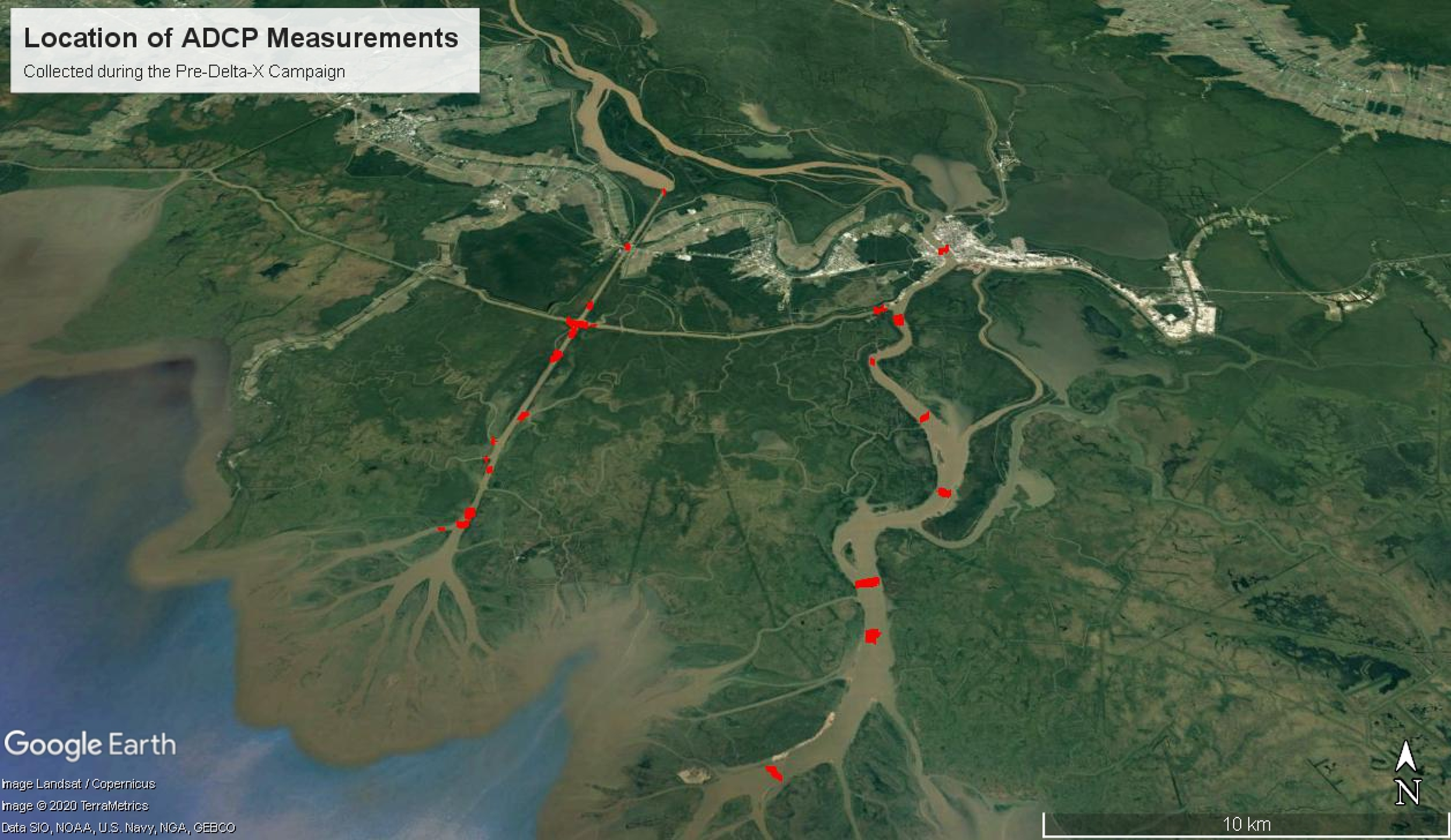
Figure 2. Locations of transect sites across the Atchafalaya River Basin in southern Louisiana.
Instrument Description
Measurements of river discharge were collected across multiple channels in the Atchafalaya River Basin in south Louisiana (Figure 2) using a SonTek RiverSurveyor M9 acoustic doppler current profiler (ADCP) instrument. The SonTek M9 ADCP system, which includes an ADP unit, a Power Control Module (PCM), a GPS antenna, and a field laptop, were configured using the DGPS setup option described in Section 3.6 of the RiverSurveyor Live Manual (SonTek, 2018). Compass calibration was completed following Section 6.11.1 of the RiverSurveyor Live Manual (SonTek, 2018) and instrument settings were input according to Section 6.9.
The ADCP was mounted on a hydro board, which was allowed to drift alongside the boat while maintaining a transect perpendicular to flow (Figure 1). The impact from the boat was limited by slowly crabbing across each channel, allowing the ADCP to remain on the upstream side of the boat.
Additionally, salinity data were collected as an input for the system settings, and the salinity value was updated in RiverSurveyor Live settings when it changed more than 5 ppt (Mueller et al., 2013).
Transect Site Selection
Transect site selection for surveys of all wide channels (>100 m) and narrow channels (>10 m) followed the guidelines in Mueller et al. (2013) to space the transects at six times the river width. Sites were selected to coincide with AirSWOT swaths in the Atchafalaya River Basin and each water level measurement location.
Data Acquisition and Processing
Methods for transect data collection are described in Section 6.13 of the RiverSurveyor Live Manual (SonTek, 2018).
Raw data files produced for each transect were exported from RiverSurveyor Live in the River Survey File (.riv) format. The *.riv files were processed using the RiverSurveyor Live software and detailed transect data are exported in six additional file formats: *.wsp, *.mat, *.sum, *.vel, *.snr, and *.dis. The *.wsp file is the workspace file produced when processing or reprocessing the *.riv file. The *.mat file contains most of the original *.riv data but can be easily accessed in Matlab. The *.sum file contains a summary of instrument parameters, water depth, location coordinates, and boat information along the transect. The *.vel and *.snr, files contain velocity and signal to noise ratio data for each vertical profile along the transect. The *.dis file contains summary discharge data for each transect.
Data Access
These data are available through the Oak Ridge National Laboratory (ORNL) Distributed Active Archive Center (DAAC).
Pre-Delta-X: River Discharge Channel Surveys across Atchafalaya Basin, LA, USA, 2016
Contact for Data Center Access Information:
- E-mail: uso@daac.ornl.gov
- Telephone: +1 (865) 241-3952
References
Mueller, D.S. 2016. QRev—Software for computation and quality assurance of acoustic doppler current profiler moving-boat streamflow measurements. User’s Manual V2.8. Open-File Report. https://doi.org/10.3133/ofr20161052
Mueller, D.S., C.R. Wagner, M.S. Rehmel, K.A. Oberg, and F. Rainville. 2013. Measuring discharge with acoustic Doppler current profilers from a moving boat. In: US Geological Survey Techniques and Methods, Book 3, Chapter A22. https://dx.doi.org/10.3133/tm3A22
SonTek. 2018. RiverSurveyor S5/M9 System Manual Software Version 4.1 Firmware Version 4.02. A Xylem Brand.
Roberts, H.H. 1997. Dynamic changes of the Holocene Mississippi River delta plain: The delta cycle. Journal of Coastal Research, 605–627. https://www.jstor.org/stable/4298659
Steyer, G.D., C.E. Sasser, J.M. Visser, E.M. Swenson, J.A. Nyman, and R.C. Raynie. 2003. A proposed coast-wide reference monitoring system for evaluating wetland restoration trajectories in Louisiana. Environmental Monitoring and Assessment, 81(1/3):107–117. https://doi.org/10.1023/A:1021368722681