Documentation Revision Date: 2023-09-21
Dataset Version: 2
Summary
This dataset includes two files in comma-separated values (*.csv) format.
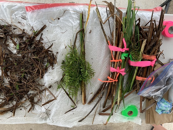
Figure 1: Aboveground vegetation sorted by species into biomass and necromass components.
Citation
Castañeda-Moya, E., and E. Solohin. 2023. Delta-X: Aboveground Vegetation Structure, Herbaceous Wetlands, MRD, LA, USA, V2. ORNL DAAC, Oak Ridge, Tennessee, USA. https://doi.org/10.3334/ORNLDAAC/2240
Table of Contents
- Dataset Overview
- Data Characteristics
- Application and Derivation
- Quality Assessment
- Data Acquisition, Materials, and Methods
- Data Access
- References
- Dataset Revisions
Dataset Overview
This dataset provides mean stem diameter, mean height, dominant species, hydrogeomorphic zone (HGM), and stem density for vegetation in herbaceous wetlands collected in the Atchafalaya and Terrebonne basins in southeastern coastal Louisiana. The data were collected during the Delta-X Spring and Fall deployments in March and August, 2021 respectively. Field measurements were conducted at six sites in the Atchafalaya (N = 3) and Terrebonne (N = 3) basins. Five of the sites were adjacent to sites from the Coastwide Reference Monitoring System (CRMS; Steyer et al., 2003), and the other site was in the Wax Lake Delta (WLD) without appropriate adjacent CRMS sites. Sites in both basins were chosen to represent a salinity gradient including freshwater, brackish, and saline ecosystems. At each herbaceous wetland site, duplicate sampling stations (30 m apart) were established parallel to the wetland edge at 25 and 50 m within the intertidal zone to capture within site variability in vegetation dynamics and soil properties.
Project: Delta-X
The Delta-X mission is a 5-year NASA Earth Venture Suborbital-3 mission to study the Mississippi River Delta in the United States, which is growing and sinking in different areas. River deltas and their wetlands are drowning as a result of sea level rise and reduced sediment inputs. The Delta-X mission will determine which parts will survive and continue to grow, and which parts will be lost. Delta-X begins with airborne and in situ data acquisition and carries through data analysis, model integration, and validation to predict the extent and spatial patterns of future deltaic land loss or gain.
Related dataset
Castaneda, E., A.I. Christensen, M. Simard, A. Bevington, R. Twilley, and A. Mccall. 2020. Pre-Delta-X: Vegetation Species, Structure, Aboveground Biomass, MRD, LA, USA, 2015. ORNL DAAC, Oak Ridge, Tennessee, USA. https://doi.org/10.3334/ORNLDAAC/1805
Castañeda-Moya, E., and E. Solohin. 2023. Delta-X: Aboveground Biomass and Necromass across Wetlands, MRD, Louisiana, 2021, V2. ORNL DAAC, Oak Ridge, Tennessee, USA. https://doi.org/10.3334/ORNLDAAC/2237
Related Publication
Thomas, N., M. Simard, E. Castañeda-Moya, K. Byrd, L. Windham-Myers, A. Bevington, and R.R. Twilley. 2019. High-resolution mapping of biomass and distribution of marsh and forested wetlands in southeastern coastal Louisiana. International Journal of Applied Earth Observation and Geoinformation 80:257–267. https://doi.org/10.1016/j.jag.2019.03.013
Acknowledgement
This study was funded by the NASA Science Mission Directorate’s Earth Science Division through the Earth Venture Suborbital-3 Program NNH17ZDA001N-EVS3.
Data Characteristics
Spatial Coverage: Atchafalaya and Terrebonne Basins, Mississippi River Delta (MRD) floodplain, southern coast of Louisiana, USA
Spatial Resolution: Points
Temporal Coverage: Spring: 2021-03-21 to 2021-03-31 and Fall: 2021-08-19 to 2021-08-27
Temporal Resolution: One-time measurements
Site Boundaries: Latitude and longitude are given in decimal degrees.
| Site | Westernmost Longitude | Easternmost Longitude | Northernmost Latitude | Southernmost Latitude |
|---|---|---|---|---|
| Atchafalaya and Terrebonne Basins | -91.8852 | -90.82192 | 29.51 | 29.1714 |
Data File Information
There are two files in comma-separated values (.csv) format:
DeltaX_AGB_Vegetation_Structure_Spring_2021_v2.csv and DeltaX_AGB_Vegetation_Structure_Fall_2021_v2.csv
Table 1. Variables in the data files.
| Variable | Units of measurement | Description |
|---|---|---|
| basin | Atchafalaya or Terrebonne basins | |
| campaign | Spring_2021 and Fall_2021 | |
| date | YYYY-MM-DD | Date collected |
| latitude | degrees north | Location of sampling site |
| longitude | degrees east | Location of sampling site |
| site_id | Site name | |
| hydrogeomorphic_zone | The hydrogeomorphic zones are intertidal and high intertidal. Note that this is an update from the previous version which included supratidal | |
| sampling_station | Sampling station | |
| dominant_species | Dominant species | |
| quarter_id | Sampling unit | |
| vegetation_class | Aboveground biomass (AGB) or necromass (AGN) | |
| number_of_stems | Number of stems measured in a quarter | |
| mean_height | cm | Average height of plants within a quarter |
| mean_diameter | mm | Average diameter of plant stems within a quarter. |
| stem_density | stems per m2 | Number of plant stems per unit area |
Application and Derivation
Vegetation structure measurements will be used to calibrate remote sensing data (e.g., UAVSAR, AVRIS) and hydrodynamic and sediment transport models. This research will contribute to a better understanding of how vegetation dynamics and zonation are likely to be influenced by changing ecosystems across deltaic basins. Additionally, the results of this study will be used to generate landscape-level vegetation mapping and patterns to identify indicators of ecosystem vulnerability across multiple coastal basins and environmental settings.
Quality Assessment
Structural attributes measured within plot quarters were averaged to estimate mean values and standard errors (± 1 SE) for all plots across all sites.
Data Acquisition, Materials, and Methods
The Spring and Fall 2021 field campaigns were conducted across the Atchafalaya and Terrebonne basins to assess changes in aboveground vegetation with seasonality along salinity and soil nutrient gradients. The study period was conducted during March and August, 2021 as these periods correspond to the early phase of the vegetation growing season and the peak of the spring river flood season, while August-September is considered the period of peak biomass and a period of low river discharge.
Five out of the six selected sites for field measurements are part of the Coastal Reference Monitoring System (CRMS; Steyer et al., 2003) and are labeled with ‘CRMS’ in the data files. The other site is in the Wax Lake Delta (WLD) without appropriate adjacent CRMS sites. Sites in both basins were chosen to represent a salinity gradient including freshwater, brackish, and saline ecosystems.
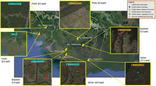
Figure 2. Study site locations.
At each herbaceous wetland site, duplicate sampling stations (30 m apart) were established parallel to the wetland edge at 25 and 50 m within the intertidal zone to capture within site variability in vegetation dynamics and soil properties. In WLD, due to a variety of elevation ranges within the wetland site, duplicate stations were established in the high and intermediate intertidal zones. For the herbaceous wetland sites, vegetation structure measurements included stem density (# stems m-2), stem height (cm), and stem diameter (mm). Stem density was calculated for all species by counting all individual plant stems within the plot. Due to the high density of stems per unit area, plots were divided into four quarters (area = 0.0625 m2) to measure the diameter and height of all individuals within one or two of four quarters at all sites, except at the high intertidal zone in Mike Island, WLD during both campaigns. A 1-m2 quadrat was used to measure and count all plant stems within the quadrat due to the low density of stems. Vegetation height and diameter were measured using a meter stick (1-mm resolution) and a digital caliper (0.01-mm resolution), respectively. In the lab, the aboveground plant material collected at all plots was initially sorted by species using standard field protocols.
Data Access
These data are available through the Oak Ridge National Laboratory (ORNL) Distributed Active Archive Center (DAAC).
Delta-X: Aboveground Vegetation Structure, Herbaceous Wetlands, MRD, LA, USA, V2
Contact for Data Center Access Information:
- E-mail: uso@daac.ornl.gov
- Telephone: +1 (865) 241-3952
References
Castaneda, E., A.I. Christensen, M. Simard, A. Bevington, R. Twilley, and A. Mccall. 2020. Pre-Delta-X: Vegetation Species, Structure, Aboveground Biomass, MRD, LA, USA, 2015. ORNL DAAC, Oak Ridge, Tennessee, USA. https://doi.org/10.3334/ORNLDAAC/1805
Castañeda-Moya, E., and E. Solohin. 2023. Delta-X: Aboveground Biomass and Necromass across Wetlands, MRD, Louisiana, 2021, V2. ORNL DAAC, Oak Ridge, Tennessee, USA. https://doi.org/10.3334/ORNLDAAC/2237
Steyer, G.D., C.E. Sasser, J.M. Visser, E.M., Swenson, J.A. Nyman, and R.C. Raynie. 2003. A proposed coast-wide reference monitoring system for evaluating wetland restoration trajectories in Louisiana. Environmental Monitoring and Assessment 81:107–117. https://doi.org/10.1023/A:1021368722681
Thomas, N., M. Simard, E. Castañeda-Moya, K. Byrd, L. Windham-Myers, A. Bevington, and R.R. Twilley. 2019. High-resolution mapping of biomass and distribution of marsh and forested wetlands in southeastern coastal Louisiana. International Journal of Applied Earth Observation and Geoinformation 80:257–267. https://doi.org/10.1016/j.jag.2019.03.013
Dataset Revisions
|
Version |
Release Date |
Revision Notes |
|
2.0 |
2023-09-21 |
Both data files were replaced. The column hydrogeomorphic_zone was updated in both data files; “supratidal” is no longer in the data files |
|
1.1 |
2022-06-26 |
Version 1 updated with a fall campaign data file |
|
1 |
2022-06-26 |
Version 1 |