Documentation Revision Date: 2024-01-11
Dataset Version: 1
Summary
There are two data files in cloud optimized GeoTIFF (COG) format with this dataset.

Figure 1. Total subsidence map for the Delta-X study area.
Citation
Varugu, B., and C. Jones. 2023. Delta-X: Land Subsidence Rate, Mississippi River Delta (MRD), Louisiana, USA. ORNL DAAC, Oak Ridge, Tennessee, USA. https://doi.org/10.3334/ORNLDAAC/2307
Table of Contents
- Dataset Overview
- Data Characteristics
- Application and Derivation
- Quality Assessment
- Data Acquisition, Materials, and Methods
- Data Access
- References
Dataset Overview
This dataset provides estimates of land subsidence rates for the Delta-X domain area within the Atchafalaya and Terrebonne basins for 2021. The study area is a portion of the Mississippi River Delta in coastal Louisiana, U.S. The total subsidence is calculated as the sum of deep and shallow vertical elevation change rates. The deep subsidence rate is based on information from the Coastal Protection and Restoration Authority (CPRA) of Louisiana, documented in the Phase-4 subsidence trend report prepared for and provided by CPRA (Applied Coastal, 2022). The shallow subsidence is calculated for the Delta-X study area by interpolation of publicly available data provided by CPRA for their coast-wide estimation of shallow subsidence in the 2023 Coastal Master Plan, published in Fitzpatrick et al. (2021). The total subsidence rates and the estimated uncertainty in the total subsidence rates are provided as separate files in cloud optimized GeoTIFF (COG) format at 30-m (0.0003 decimal degrees) resolution.
Project: Delta-X
The Delta-X mission is a 5-year NASA Earth Venture Suborbital-3 mission to study the Mississippi River Delta in the United States, which is growing and sinking in different areas. River deltas and their wetlands are drowning as a result of sea level rise and reduced sediment inputs. The Delta-X mission will determine which parts will survive and continue to grow, and which parts will be lost. Delta-X begins with airborne and in situ data acquisition and carries through data analysis, model integration, and validation to predict the extent and spatial patterns of future deltaic land loss or gain.
Acknowledgements
This study was funded by the NASA Science Mission Directorate’s Earth Science Division through the Earth Venture Suborbital-3 Program (grant NNH17ZDA001N-EVS3).
Data Characteristics
Spatial Coverage: Atchafalaya and Terrebonne basins, Louisiana, USA
Spatial Resolution: 30 m (0.0003 decimal degrees).
Temporal Coverage: 2021-01-01 to 2021-12-31
Temporal Resolution: annual
Site Boundaries: Latitude and longitude are given in decimal degrees.
| Site | Westernmost Longitude | Easternmost Longitude | Northernmost Latitude | Southernmost Latitude |
|---|---|---|---|---|
| Atchafalaya and Terrebonne basins, Louisiana | -91.8452 | -90.1958 | 30.0106 | 28.9811 |
Data File Information
The dataset contains two data files in cloud optimized GeoTIFF (COG) format:
- DeltaX_SubsidenceRate_mmyr_30m.tif
- Contains total subsidence rate estimates in mm yr-1 for the Delta-X domain area within the Atchafalaya and Terrebonne basins for 2021 at 30-m horizontal resolution
- DeltaX_SubsidenceRateUncertainty_mmyr_30m.tif
- Contains subsidence rate uncertainty estimates in mm yr-1 for the Delta-X domain area within the Atchafalaya and Terrebonne basins for 2021 at 30-m horizontal resolution
Missing data are indicated by a value of -9999.
The GeoTIFFs are in geographic coordinates (EPSG 4326, WGS84 datum). The pixel size is approximately 0.0003 degrees (~ 30 m).
Application and Derivation
The subsidence estimates are used with Delta-X numerical, hydrodynamic, and ecological models for predicting the long-term land loss/gain in the Delta-X study region.
Quality Assessment
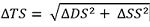
For the shallow subsidence (SS) uncertainty, the method of CPRA was used. A 1st quartile (25%) (SSCPRA_1Q) and median (SSCPRA_median) of the SS measurements from the rod surface elevation tables (RSETs) within a predefined ecoregion were computed, which provide a lower and higher range of SS to be used. An uncertainty estimate for SS (ΔSS) was then computed using the difference of measurements. ΔSS was determined by selecting the larger of (a) the difference used by CPRA or (b) the difference between the kriged fit estimate and the CPRA 1st quartile value:

We assume 1.5 mm yr-1 uncertainty for DS (ΔDS). Then, the uncertainty estimate for TS (ΔTS) is calculated as:
Final maps were compared with large scale interpolated maps derived from region wide Global Navigation Satellite System (GNSS) network maintained by National Geodetic Survey and region wide shallow subsidence maps given by CPRA (Fitzpatrick et al. 2021).
Data Acquisition, Materials, and Methods
This dataset provides total subsidence rate estimates for the Delta-X domain area encompassing the Atchafalaya and Terrebonne basins. Subsidence in coastal Louisiana is driven by multiple processes (tectonic, glacial isostatic adjustment (GIA),sediment compaction, and anthropogenic processes like water, oil, and gas extraction) (Allison et al. 2016; Jones et al. 2016), so there are large spatial and depth-wise variations in subsidence across coastal Louisiana. Loss of interferometric coherence over the vegetated and periodically inundated land precludes dense and accurate subsidence measurements using Sentinel-1 C-band InSAR in the Delta-X study area. Hence, point-based measurements from ground-based instruments have so far provided the best subsidence estimates in the Delta-X study area.
The methodology used by CPRA for estimating the total subsidence as a sum of deep and shallow subsidence components was used for this product (Figure 1; Fitzpatrick et al., 2021). GNSS/GPS continuously operating reference stations (CORS) with deep foundations and campaign GPS surveys of deep-seated monuments are sensitive to subsidence below the depth of the footing depth, which varies up to ~20 m in the study area. Since most shallow subsidence is expected to come from sediment compaction occurring in the top few meters (0-10 m, Jankowski et al. 2017), GPS is expected to mainly measure deep subsidence due to tectonic and GIA processes, plus possibly some compaction of the deeper Holocene sediments.
CPRA commissioned a survey of GPS benchmarks across the state to supplement the limited CORS data available. The Phase 4 measurements and analysis completed the collection, mainly obtaining many more measurements in south-central and southwestern parts of the state. These data provide the basis for the deep subsidence (DS) measurements that are used for the Delta-X project. Following the results in the report (Applied Coastal, 2022), the deep subsidence is estimated to be in the range 5-8 mm yr-1 (6.5 +/− 1.5 mm yr-1).
For Delta-X, the shallow subsidence (SS) is calculated for the Delta-X study area by interpolation of publicly available data provided by CPRA and comprised of measurements from CORS GNSS stations, Global Positioning System (GPS) benchmark surveys, Rod Surface Elevation Table (RSET)/Surface Elevation Table (SET) measurements combined with feldspar marker horizons (MH). These instruments measure the surface elevation change above their base, from which soil accretion, measured at nearby MH sites, is subtracted to get SS. Hence, in the study area, the shallow subsidence measurements account for subsidence above the RSET instrument base, and the deep subsidence measurement of subsidence below the GNSS/GPS monument base. Fitzpatrick et al. (2021) provides a map showing the overlap or gap between the two baselines. In the Atchafalaya basin, there is a none-to-small gap, and in the Terrebonne basin there is a few meters of overlap. These gaps were accounted for in the uncertainty estimation. A Kriging interpolated shallow subsidence (SSKriging) map at 30-m posting was computed using the RSET measurements published by CPRA (Fitzpatrick et al., 2021). More than 200 measurements were used to generate a coast wide subsidence map using an interpolation range of 100 km and assuming a measurement error (nugget) of 1 mm yr-1.
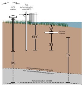
Figure. 2. Representation of measurements used to develop subsidence rates for the 2023 Coastal Master Plan. Deep subsidence (DS) is measured with GPS and accounts for subsidence below the station footing. The RSET station measures the sum of shallow subsidence (SS) and vertical soil accretion (VA) that occurs between the soil surface and the footing of the RSET. Feldspar marker horizon measurements provide VA. This combination allows calculation of the total subsidence (TS = SS + DS). If the base of the GPS station is not the same as the base of the RSET, then TS is underestimated if there is a gap, and overestimated if there is overlap. Figure 5 of Fitzpatick et al. (2021) shows the potential overlap. (Source: Fitzpatrick et al. 2021, Fig. 4, modified from Cahoon et al., 2006 and Jankowski et al., 2017).
Final map of total subsidence (TS) is obtained by adding SSKriging and CPRA DS value of 6.5 mm yr-1 (Figure 3).
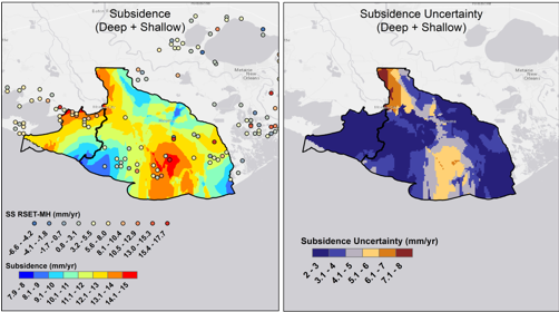
Figure 3. Estimated subsidence (left) in the Delta-X study area with estimated uncertainty (right). Estimations were based on data from the Louisiana Coastal Protection and Restoration Authority (Fitzpatrick et al., 2021; Applied Coastal, 2022).
Data Access
These data are available through the Oak Ridge National Laboratory (ORNL) Distributed Active Archive Center (DAAC).
Delta-X: Land Subsidence Rate, Mississippi River Delta (MRD), Louisiana, USA
Contact for Data Center Access Information:
- E-mail: uso@daac.ornl.gov
- Telephone: +1 (865) 241-3952
References
Allison, M., B. Yuill, T. Törnqvist, F. Amelung, T. Dixon, G. Erkens, R. Stuurman, C. Jones, G. Milne, M. Steckler, J. Syvitski, and P. Teatini. 2016. Global risks and research priorities for coastal subsidence. Eos 97. https://doi.org/10.1029/2016eo055013
Applied Coastal. 2022. Recent Subsidence Trends for Coastal Louisiana: Phase 4 – Southwestern Louisiana Chenier Plain, Teche/Vermilion Basin, Atchafalaya Basin, Western Pontchartrain Basin, and the Mississippi River Delta Basin. Final Report prepared by Applied Coastal Research and Engineering. Coastal Protection and Restoration Authority, Baton Rouge, Louisiana, 80 p. https://cims.coastal.louisiana.gov/RecordDetail.aspx?Root=0&sid=24941
Cahoon, D.R., P.F. Hensel, T. Spencer, D.J. Reed, K.L. McKee, and N. Saintilan. 2006. Coastal wetland vulnerability to relative sea-level rise: wetland elevation trends and process controls. Pp. 271-292 in J.T.A. Verhoeven, B. Beltman, R. Bobbink, and D.F. Whigham (eds.). Wetlands and Natural Resource Management. Ecological Studies (Analysis and Synthesis), 190. Berlin Heidelberg: Springer-Verlag. https://doi.org/10.1007/978-3-540-33187-2_12
Fitzpatrick, C., K.L. Jankowski, and D. Reed. 2021. 2023 Coastal Master Plan: Attachment B3: Determining Subsidence Rates for Use in Predictive Modeling, Version 3, 71 p., Coastal Protection and Restoration Authority, Baton Rouge, Louisiana, USA. https://coastal.la.gov/wp-content/uploads/2023/08/B3_DeterminingSubsidenceRates_Mar2021_v3.pdf
Jankowski, K.L., T.E. Törnqvist, and A.M. Fernandes. 2017. Vulnerability of Louisiana’s coastal wetlands to present-day rates of relative sea-level rise. Nature Communications 8:14792. https://doi.org/10.1038/ncomms14792
Jones, C.E., K. An, R.G. Blom, J.D. Kent, E.R. Ivins, and D. Bekaert. 2016. Anthropogenic and geologic influences on subsidence in the vicinity of New Orleans, Louisiana. Journal of Geophysical Research: Solid Earth 121:3867–3887. https://doi.org/10.1002/2015JB012636