Documentation Revision Date: 2022-09-22
Dataset Version: 2
Summary
There are two data files in comma separated values (CSV) format.
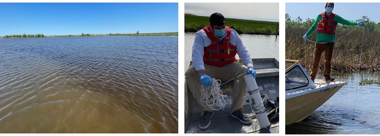
Figure 1: Types of waters being sampled in this study region (left), van Dorn sampler being used to collect surface samples (middle), and deployment of van Dorn sampler (right).
Citation
Fichot, C.G., N. Ghosh, J. Harringmeyer, and M. Weiser. 2022. Delta-X: Total Suspended Solids Concentration across MRD, LA, USA, 2021, Version 2. ORNL DAAC, Oak Ridge, Tennessee, USA. https://doi.org/10.3334/ORNLDAAC/2075
Table of Contents
- Dataset Overview
- Data Characteristics
- Application and Derivation
- Quality Assessment
- Data Acquisition, Materials, and Methods
- Data Access
- References
- Dataset Revisions
Dataset Overview
This dataset provides measurements of total suspended solids concentrations (TSS) of surface waters in the Atchafalaya River and Terrebonne Basins during the spring (2021-03-25 to 2021-04-22) and fall (2021-08-14 to 2021-09-24) field efforts by the Delta-X project. Field sampling was paused on August 25 and resumed on September 13, 2021, due to the landfall of Hurricane Ida on 2021-08-26 approximately 70 km east of the study site. Water quality changes caused by the hurricane were expected to be minimal. Samples were collected from ~0.5 m of surface in multiple channels of varying width (from a few meters to >100 m), near Delta-X intensive study sites, in open bays and lakes, and at few locations in the nearshore Gulf of Mexico. For each collection, the water sample volume was filtered, and the suspended particles retained on the filter were weighed after drying. The TSS concentration was calculated as the difference of the filter weight (before and after filtration) divided by the volume filtered.
Project: Delta-X
The Delta-X mission is a 5-year NASA Earth Venture Suborbital-3 mission to study the Mississippi River Delta in the United States, which is growing and sinking in different areas. River deltas and their wetlands are drowning as a result of sea level rise and reduced sediment inputs. The Delta-X mission will determine which parts will survive and continue to grow, and which parts will be lost. Delta-X begins with airborne and in situ data acquisition and carries through data analysis, model integration, and validation to predict the extent and spatial patterns of future deltaic land loss or gain.
Related dataset
Castaneda, E., A.I. Christensen, M. Simard, D.J. Jensen, R. Twilley, and R. Lane. 2020. Pre-Delta-X: Total Suspended Solids of Surface Water across MRD, LA, USA, 2015-2016. ORNL DAAC, Oak Ridge, Tennessee, USA. https://doi.org/10.3334/ORNLDAAC/1802
- Total suspended solids measured across the MRD during the Pre-DeltaX field mission in the Spring 2015 and Fall 2016.
Acknowledgement
This study was supported by the NASA Earth Venture Suborbital-3 Program (grant NNH17ZDA001N-EVS3) and Research and Technology Development funding at NASA's Jet Propulsion Laboratory (Strategic R&TD FY17–19).
Data Characteristics
Spatial Coverage: Atchafalaya and Terrebonne Basins and the Wax Lake Delta (WLD), Louisiana, USA
Spatial Resolution: Point
Temporal Coverage: 2021-03-25 to 2021-09-24
Temporal Resolution: Point
Study Area: Latitude and longitude are given in decimal degrees.
| Site | Westernmost Longitude | Easternmost Longitude | Northernmost Latitude | Southernmost Latitude |
|---|---|---|---|---|
| Atchafalaya and Terrebonne Basins, Wax Lake Delta (WLD), Louisiana, USA | -91.4676 | -90.5696 | 29.7546 | 28.7912 |
Data File Information
This dataset includes two files in comma separated values (CSV) format: DeltaX_TSS_Spring2021.csv and DeltaX_TSS_Fall2021.csv.
Missing data are indicated by the no_data value -9999.
Table 1. Variables in the CSV files.
|
Variable |
Units |
Description |
|---|---|---|
|
basin |
|
Basin name: “Atchafalaya” or “Terrebonne” |
|
site_id |
|
Site identifier with format <basin>_<mmdd>_<station type><station number>, where mm = month and dd = day. See Table 2 for basin and station type abbreviations |
|
campaign |
|
Field campaign: "Spring_2021" or "Fall_2021" |
|
latitude |
degrees north |
Latitude of sampling location |
|
longitude |
degrees east |
Longitude of sampling location |
|
date |
YYYY-MM-DD |
Date of sampling and measurement |
|
time |
HH:MM:SS |
UTC time of sampling |
|
depth |
m |
Depth of sampling |
|
tss_concentration |
mg L-1 |
Mean concentration of total suspended solids (TSS) |
|
SD_tss_concentration |
mg L-1 |
Standard deviation of TSS concentration measurements |
Table 2. Abbreviations encoded in site_id variable.
| Abbreviation | Description |
|---|---|
| Basin names | |
| WLD | Atchafalaya Basin (including Wax Lake Delta) |
| TB | Terrebonne Basin |
| Type of sampling station | |
| S | Full station: Water samples for total suspended solids (TSS) and Particulate Organic Carbon (POC) were collected along with water reflectance, measurements from the Sequoia Scientific® LISST-200X instrument (LISST), and water-quality indicators from ProDSS probe. |
| D | Dry stations: No water samples for TSS were collected. Measurements of water reflectance, from the LISST, and water-quality indicators from ProDSS probe were collected. |
| B | Basic station: Only measurements of LISST, and water-quality indicators from ProDSS probe were collected. |
Application and Derivation
During the Delta-X Campaigns, in situ water samples for laboratory-based measurements of TSS concentration were collected at a number of sites across the Atchafalaya and Terrebonne basins. These sampling sites spanned large and small channels at locations chosen to cover a representative range of suspended solids concentration from a variety of hydrodynamic and physical settings typically encountered across the Atchafalaya and Terrebonne basins.
This dataset is used to calibrate and validate Delta-X’s algorithms used for the retrieval of total suspended solids concentration from AVIRIS-NG imagery and to inform and validate Delta-X’s sediment transport models. These TSS concentrations measurements represent discrete measurements and are paired with other measurements of in situ water-quality indicators, beam attenuation coefficient at 670 nm, average suspended particle size, suspended particle size distributions, and in situ and airborne water reflectance (all provided as separate data sets). These location- and time-specific measurements are compared to numerical models to calibrate and validate its parameters. The models quantify the mesoscale (i.e., on the order of 1 ha) patterns of soil accretion that control land loss and gain and predict the resilience of deltaic floodplains under projected relative sea-level rise. Understanding and mitigating the impact of the relative sea-level rise on coastal deltas is urgent. If ignored, relative sea-level rise will very soon have devastating consequences on the livelihood of the half-billion people that live in these low-lying coastal regions.
Quality Assessment
Three replicates of TSS measurements were made per sample, which provided a mean and standard deviation for each sample. The microbalance used to weigh the filters was calibrated before any new batch of measurement. Blanks were produced and measured for every ~20 samples by filtering 300 mL of Milli-Q water following the exact same procedure as for the samples. The blanks were strictly used to ensure that there were no bias in the measured weights due to potential balance drift between pre- and post-weighing filters.
Data Acquisition, Materials, and Methods
TSS were measured from surface water samples collected at locations across the Atchafalaya and Terrebonne Basins, portions of the Mississippi River Delta in coastal Louisiana, U.S. These locations represent a variety of hydrodynamic conditions within this wetland ecosystem (Figure 2). Sample collection occurred during the spring (2021-03-25 to 2021-04-22) and fall (2021-08-14 to 2021-09-24) field efforts by the Delta-X project. Field sampling was paused on August 25 and resumed on September 13, 2021, due to the landfall of Hurricane Ida on 2021-08-26 approximately 70 km east of the study site. Water quality changes caused by the hurricane were expected to have minimal effects on these TSS measurements.
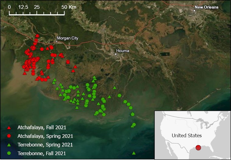
Figure 2. Delta-X 2021 sampling sites for total suspended solids (TSS) labeled by basin and field season.
Sampling Procedure
Each in situ water sample was collected directly from the boat by submerging a 4-L van Dorn sampler about 0.5 m beneath the surface. The volume sampled was then transferred in its entirety into a 4-L amber plastic bottle (HDPE) and kept in a cooler with ice until analysis in the lab within a few hours. The van Dorn sampler was rinsed multiple times with site water before collecting the sample. In the lab, three sub-samples (typically 150 to 300 mL for most samples, but up to 500 mL in coastal ocean samples) from the 4-L sample were then filtered through three different pre-combusted and pre-weighed 47-mm-diameter, 0.7-µm glass-fiber filters (Whatman® GF/F). After filtration, the filters were kept frozen at -20°C until return to the laboratory. The filters were dried at 75°C for 24 hours and cooled in a dessicator before being weighed again. Filter preparation, filtration procedure and drying times followed the recommendations of Neukermans et al. (2012). Filters were weighed in the laboratory using a Sartorius Cubis MSE3.6P000DM Microbalance (readability of 1 µg).
Three replicates of TSS measurements were made per sample, which provided a mean and standard deviation for each sample. The microbalance used to weigh the filters was calibrated before any new batch of measurement. Blanks were produced and measured for every ~20 samples by filtering 300 mL of Milli-Q water following the exact same procedure as for the samples. The blanks were used to ensure that there was no bias in the measured weights due to potential balance drift between pre- and post-weighing filters.
Data Access
These data are available through the Oak Ridge National Laboratory (ORNL) Distributed Active Archive Center (DAAC).
Delta-X: Total Suspended Solids Concentration across MRD, LA, USA, 2021, Version 2
Contact for Data Center Access Information:
- E-mail: uso@daac.ornl.gov
- Telephone: +1 (865) 241-3952
References
Neukermans, G., K. Ruddick, H.Loisel, H., and P. Roose. 2012. Optimization and quality control of suspended particulate matter concentration measurement using turbidity measurements. Limnology and Oceanography Methods 10:1011–1023. https://doi.org/10.4319/lom.2012.10.1011
Dataset Revisions
| Version | Release Date | Revision Notes |
| 2.0 | 2022-09-22 | Fall 2021 data added. Title revised. |
| 1.0 | 2022-05-02 | Original release with Spring 2021 data |