Documentation Revision Date: 2022-09-01
Dataset Version: 1
Summary
Sonar points were collected while the research vessel was operational and conditions were appropriate. Four teams collected sonar data: the Jet Propulsion Laboratory (JPL) using the Lowrance Fish Finder, University of North Carolina (UNC) using a SonarMite Echo Sounder, Boston University (BU) using a Lowrance Fish Finder, and California Institute of Technology (Caltech) using a Lowrance Fish Finder.
The Delta-X mission is a 5-year NASA Earth Venture Suborbital-3 mission to study the Mississippi River Delta in the United States, which is growing and sinking in different areas. River deltas and their wetlands are drowning as a result of sea level rise and reduced sediment inputs. The Delta-X mission will determine which parts will survive and continue to grow, and which parts will be lost. Delta-X begins with airborne and in situ data acquisition and carries through data analysis, model integration, and validation to predict the extent and spatial patterns of future deltaic land loss or gain.
The dataset includes 119 files are in comma-separated values (CSV) format and one file in compressed keyhole markup language (KMZ).
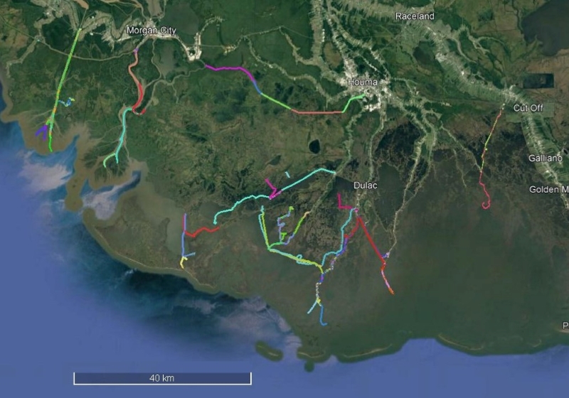
Figure 1. Location 2021 sonar bathymetry surveys shown as colored lines in the Atchafalaya and Terrebonne basins of the Mississippi River Delta (MRD). The towns of Morgan City and Houma in coastal Louisiana are shown. Source: deltax_sonar_routes.kmz
Citation
Christensen, A.L., J.M. Mallard, J. Nghiem, J. Harringmeyer, M. Simard, T.M. Pavelsky, M.P. Lamb, and C.G. Fichot. 2022. Delta-X: Sonar Bathymetry Survey of Channels, MRD, Louisiana, 2021. ORNL DAAC, Oak Ridge, Tennessee, USA. https://doi.org/10.3334/ORNLDAAC/2085
Table of Contents
- Dataset Overview
- Data Characteristics
- Application and Derivation
- Quality Assessment
- Data Acquisition, Materials, and Methods
- Data Access
- References
Dataset Overview
This dataset includes bathymetry data for water channels in a portion of the Mississippi River Delta (MRD) of coastal Louisiana. The data were collected using sonar during field efforts of the Delta-X Campaign taking place during 2021. In situ continuous surveys of channel bathymetry were conducted in the Atchafalaya and Terrebonne basins using either a Lowrance HDS-Live Fish Finder with Active Imaging 3-in-1 Transducer or a SonarMite Echo Sounder mounted on the side or back of the research boat. The sounder depth observations were delineated by the date, time, and location. These bathymetry measurements were used to generate a ‘merged’ digital elevation model (DEM) through interpolation with ancillary DEMs.
Project: Delta-X
The Delta-X mission is a 5-year NASA Earth Venture Suborbital-3 mission to study the Mississippi River Delta in the United States, which is growing and sinking in different areas. River deltas and their wetlands are drowning as a result of sea level rise and reduced sediment inputs. The Delta-X mission will determine which parts will survive and continue to grow, and which parts will be lost. Delta-X begins with airborne and in situ data acquisition and carries through data analysis, model integration, and validation to predict the extent and spatial patterns of future deltaic land loss or gain.
Related dataset
Denbina, M.W., M. Simard, T.M. Pavelsky, A.I. Christensen, K. Liu, and C. Lyon. 2020. Pre-Delta-X: Channel Bathymetry of the Atchafalaya Basin, LA, USA, 2016. ORNL DAAC, Oak Ridge, Tennessee, USA. https://doi.org/10.3334/ORNLDAAC/1807
- Bathymetric survey of in the main channels of the Atchafalaya and Wax Lake Deltas conducted during the Pre-DeltaX 2016 field studies.
Acknowledgments
This work was supported by NASA's Earth Venture Suborbital-3 (EVS-3) program (grant NNH17ZDA001N-EVS3) and Jet Propulsion Laboratory's R&TD FY17-19 program.
Data Characteristics
Spatial Coverage: Atchafalaya River and Terrebonne Basins, Louisiana, USA
Spatial Resolution: Point samples.
Temporal Coverage: 2021-03-25 to 2021-09-25
Temporal Resolution: Continuous readings during surveys at 1 Hz
Site Boundaries: Latitude and longitude are given in decimal degrees.
| Site | Westernmost Longitude | Easternmost Longitude | Northernmost Latitude | Southernmost Latitude |
|---|---|---|---|---|
| Atchafalaya River and Terrebonne Basins, Louisiana | -91.4729 | -90.4012 | 29.7038 | 29.1029 |
Data File Information
This dataset consists of 120 files: 119 files of bathymetry data in comma-separated values (.csv) format and one file in compressed keyhole markup language (.kmz).
The naming convention for the bathymetry files is deltax_sonar_AAAA_YYYYMMDD.csv; (e.g., deltax_sonar_UNC_20210922_154233.csv), where
- AAAA = data collection team: "BU", "Caltech", "JPL1", JPL2" or "UNC"
- YYYYMMDD = date of sampling in year (YYYY), month (MM), and day (DD)
Missing data or are indicated with the value -9999.
The file deltax_sonar_routes.kmz provides a map of sonar routes in compressed keyhole markup language (.kmz).
Table 1. Variables in the sonar bathymetry data files (deltax_sonar_AAAA_YYYYMMDD.csv).
| Variable | Units | Description | Collected during Pre-Delta-X campaign? |
|---|---|---|---|
| basin | Name of basin: “Atchafalaya” or “Terrebonne” | Yes | |
| sonar_id | Indicates the instrument by acronym of the team that collected the data. Lowrance HDS-Live Fish Finder with Active Imaging 3-in-1 Transducer ("JPL1", "JPL2", "BU", or "Caltech") SonarMite Echo Sounder ("UNC") |
No, Collected during Delta-X campaigns | |
| date | YYYY-MM-DD | Date of acquisition | Yes |
| time | hh:mm:ss | Time of acquisition in UTC | Yes |
| longitude | degrees east | Longitude of sonar GPS | Yes |
| latitude | degrees north | Latitude of sonar GPS | Yes |
| nearest_CRMS | Name of the nearest CRMS water level gauge with available water surface elevations relative to NAVD88 datum during the time of data collection | No. Collected during Delta-X campaigns | |
| distance_to_CRMS | m | Distance from the sonar data point to the near CRMS water level gauge | No. Collected during Delta-X campaigns |
| water_depth | m | Corrected water depth | Yes |
| water_depth_raw | m | Uncorrected water depth (without adding the vertical offset) | Yes |
| bathymetry_NAVD88 | m | Corrected bathymetry values using vertical offsets (Table 2). | No. Collected during Delta-X campaigns |
Application and Derivation
The sonar data were used to expand the existing wetland digital elevation model (DEM) to channels. These bathymetry measurements were used to generate a ‘merged’ digital elevation model (DEM) through interpolation with ancillary DEMs (e.g. Gesch et al., 2018; Shaw et al. 2016).
Quality Assessment
Recorded depths of 0 m occur when the sounder comes out of the water in rough conditions, the water depth is too shallow, or when the boat is moving at too high a speed. Therefore, 0-m depth observations were removed from the vector product.
Uncertainties in the data come from several sources. First, the vertical offset can vary by boat speed and weight distribution in the boat, but only one value was used in data correction. Error due to changes in boat draft are estimated to be 10-20cm. Second, the assumption that the water level at the nearest CRMS station is representative of water level when sonar is being measured may not always be valid. Third, the instrument error of depth was estimated to be 5-30 cm (depending on speed and depth) for the Lowrance HDS-Live Fish Finder with Active Imaging 3-in-1 Transducer and 2.5cm for the SonarMite Echo Sounder. The uncorrected and corrected depths are both included in the data files.
Data Acquisition, Materials, and Methods
For the Delta-X campaign, surveys of channel bathymetry were conducted in the Atchafalaya and Terrebonne basins of the Mississippi River Delta of coast Louisiana, U.S. during March- April and August-September of 2021 (Figure 1). Continuous surveys of bathymetry were conducted using Lowrance HDS-Live Fish Finder with Active Imaging 3-in-1 Transducer and SonarMite Echo Sounder (Ohmex Ltd, 2018) sounders. The sounder was mounted on the stern or side of the research vessel beneath the water surface. The sounder was set to record during portions of the field campaign while surveying . During channel surveys, the sonar recorded the depth, which was converted to bathymetry using horizontal and vertical offsets (Table 2).
Five teams were involved in these surveys: Boston University (BU), California Institute of Technology (Caltech), University of North Carolina-Chapel Hill (UNC), and two teams from NASA's Jet Propulsion Laboratory (JPL1, JPL2).
Boats using the Lowrance HDS-Live Fish Finder mounted the sensor to the stern of the boat and the connected GPS was located at the boat console. A horizontal offset was calculated based on the direction the boat was moving and the distance from the boat console to the location of the sounder. Each team's boat had a slightly different configuration (Table 2) and the vertical offset was estimated as the distance of the sensor below the water surface. The expected change in this distance is 10-30 cm depending on boat speed and weight distribution. Depths presented in the data are both uncorrected and corrected (with the vertical offset added to the measured instrument depth, Table 1). Boats using the Lowrance Fish Finder did not have a survey-level global navigation satellite system (GNSS) unit. Therefore, to convert depth to bathymetry, a nearby water level gauge was used to estimate water surface elevation at the time of each sounder collection point. The nearest Louisiana Coastwide Reference Monitoring System (CRMS)(CPRA 2022; Steyer et al., 2003) water level gauge with available datum-corrected water surface elevations were used for this conversion. Bathymetry data files contain the name and distance to CRMS gauge.
Boats using the SonarMite Echo Sounder mounted the sensor to a 2-m pole on the side of the boat which was lowered into the water so the Echo Sounder was fully submerged. A GNSS antenna connected to a Septentrio PolaRx5 GNSS receiver was attached to the top of the pole to record horizontal position of the Echo Sounder at 1 Hz. Error is estimated to be <10 cm due to instrument precision and changes in the boat’s position in the water. GNSS position data (latitude, longitude, ellipsoidal height relative to the NAVD88 datum) was post-processed using the Precise Point Positioning utility from Natural Resources Canada (NRCan CSRS-PPP service) and converted to orthometric heights relative to GEOID12B geoid. Orthometric height of the antenna was converted to bathymetry by subtracting the height of the antenna and water depth.
Table 2. Sonar instrument, mounting location, and offsets
| Instrument | Sensor location | Team | Vertical offset (m) | Horizontal offset (m) | |
| Lowrance HDS-Live Fish Finder with Active Imaging 3-in-1 Transducer |
stern of boat | BU | 0.29 | 3.50 | |
| Caltech | 0.30 | 2.30 | |||
| JPL1 | 0.51 | 2.30 | |||
| JPL2 | 0.35 | 4.27 | |||
| SonarMite Echo Sounder | side of boat | UNC | 0.29 | 0.00 |
Data Access
These data are available through the Oak Ridge National Laboratory (ORNL) Distributed Active Archive Center (DAAC).
Delta-X: Sonar Bathymetry Survey of Channels, MRD, Louisiana, 2021
Contact for Data Center Access Information:
- E-mail: uso@daac.ornl.gov
- Telephone: +1 (865) 241-3952
References
CPRA. 2022. Coastwide Reference Monitoring System - Wetlands Monitoring Data. Coastal Protection and Restoration Authority (CPRA) of Louisiana. Retrieved from Coastal Information Management System (CIMS) database (http://cims.coastal.louisiana.gov) Accessed 12 February 2022.
Denbina, M.W., M. Simard, T.M. Pavelsky, A.I. Christensen, K. Liu, and C. Lyon. 2020. Pre-Delta-X: Channel Bathymetry of the Atchafalaya Basin, LA, USA, 2016. ORNL DAAC, Oak Ridge, Tennessee, USA. https://doi.org/10.3334/ORNLDAAC/1807
Gesch, D.B., G.A. Evans, M.J. Oimoen, S. Arundel. 2018. The National Elevation Dataset. Pp. 83-110 in D.F. Maune and A. Nayegandhi (eds). Digital Elevation Model: technologies and applications, 3rd edition. American Society for Photogrammetry and Remote Sensing. US Geological Survey Publications Warehouse. http://pubs.er.usgs.gov/publication/70201572
Lowrance Active Imaging 3-in-1 Transducer. Product details https://www.lowrance.com/lowrance/type/sonar-transducers/activeimaging-3-in-1-transducer/
Ohmex Ltd. 2018. SonarMite V5 Echo Sounder. Retrieved June 25 June 2019 from http://www.ohmex.com/sonarmite.html.
Shaw, John B., Francois Ayoub, Cathleen E. Jones, Michael P. Lamb, Benjamin Holt, R. Wayne Wagner, Thomas S. Coffey, J. Austin Chadwick, and David Mohrig. 2016. Airborne radar imaging of subaqueous channel evolution in Wax Lake Delta, Louisiana, USA. Geophysical Research Letters 43:5035-5042. https://doi.org/10.1002/2016GL068770
Steyer, G.D., C.E. Sasser, J.M. Visser, E.M. Swenson, J.A. Nyman, and R.C. Raynie. 2003. A proposed coast-wide reference monitoring system for evaluating wetland restoration trajectories in Louisiana. Environmental Monitoring and Assessment 81:107-117. https://doi.org/10.1023/A:1021368722681