Documentation Revision Date: 2025-02-10
Dataset Version: 3
Summary
This dataset contains one data file in comma separated values (*.csv) format.

Figure 1: Suspended and bed sediment sampling locations (dots) in the Wax Lake Delta, Louisiana. Clusters of measurements are grouped together into single points on this map. Map excludes measurements made far upstream of the Wax Lake Delta or in the Terrebonne River Basin.
Citation
Nghiem, J., G. Salter, and M.P. Lamb. 2025. Delta-X: Bed and Suspended Sediment Grain Size, MRD, LA, USA, 2019-2021, V3. ORNL DAAC, Oak Ridge, Tennessee, USA. https://doi.org/10.3334/ORNLDAAC/2379
Table of Contents
- Dataset Overview
- Data Characteristics
- Application and Derivation
- Quality Assessment
- Data Acquisition, Materials, and Methods
- Data Access
- References
- Dataset Revisions
Dataset Overview
This dataset includes sediment concentration and grain size distribution measurements from suspended and bed sediment samples collected in the Atchafalaya River and Terrebonne Basins as part of the Delta-X Spring campaign between March 25 and April 2, 2021, and the Delta-X Fall campaign between August 17 and 22, 2021. In addition, ten samples were collected during a field campaign in October 2019. Samples were collected in the main channels and the interior of Mike Island in the Wax Lake Delta, Louisiana and at site CRMS0421 inside the Terrebonne Basin. Sediment samples were collected from a boat using a Van Dorn sampler (for suspended sediment samples) or a Ponar bed sampler (for bed samples). Suspended sediment samples were collected from a boat drifting at approximately the same velocity as the water flow. One sample was collected per drift. Bed samples were collected in a similar fashion. Data include measurements of sediment grain size distribution, total sediment concentration, water temperature, flow velocity, salinity, and depth.
This Version 3 updates Version 2 to include data from more samples and reprocessed laser diffraction grain size distributions with optimized sediment optical properties.
Project: Delta-X
The Delta-X mission is a 5-year NASA Earth Venture Suborbital-3 mission to study the Mississippi River Delta in the United States, which is growing and sinking in different areas. River deltas and their wetlands are drowning as a result of sea level rise and reduced sediment inputs. The Delta-X mission will determine which parts will survive and continue to grow, and which parts will be lost. Delta-X begins with airborne and in-situ data acquisition and carries through data analysis, model integration, and validation to predict the extent and spatial patterns of future deltaic land loss or gain.
This dataset provides measurements of sediment grain size distribution, total sediment concentration, water temperature, flow velocity, salinity, and depth from samples collected in the Atchafalaya River and Terrebonne Basins as part of the Delta-X Spring campaign between March 25 and April 2, 2021, and the Delta-X Fall campaign between August 17 and 22, 2021. Ten samples were additionally collected during a field campaign in October 2019. Samples were collected in the main channels and the interior of Mike Island in the Wax Lake Delta, Louisiana and at site CRMS0421 inside the Terrebonne Basin. Sediment samples were collected from a boat using a Van Dorn sampler (for suspended sediment samples) or a Ponar bed sampler (for bed samples). Suspended sediment samples were collected from a boat drifting at approximately the same velocity as the water flow. One sample was collected per drift. Bed samples were collected in a similar fashion.
Related Datasets
Castaneda, E., A.I. Christensen, M. Simard, D.J. Jensen, R. Twilley, and R. Lane. 2020. Pre-Delta-X: Total Suspended Solids of Surface Water across MRD, LA, USA, 2015-2016. ORNL DAAC, Oak Ridge, Tennessee, USA. https://doi.org/10.3334/ORNLDAAC/1802.
- Contains total suspended solids measurements of surface water in the MRD during the Pre-Delta-X campaign in Spring 2015 and Fall 2016.
Nghiem, J., G. Salter, and M.P. Lamb. 2023. Delta-X: Bed and Suspended Sediment Grain Size, MRD, LA, USA, 2021, Version 2. ORNL DAAC, Oak Ridge, Tennessee, USA. https://doi.org/10.3334/ORNLDAAC/2135
- Version 2 of this dataset
Nghiem, J., G. Salter, and M.P. Lamb. 2022. Delta-X: Bed and Suspended Sediment Grain Size, Wax Lake Delta, LA, USA, 2021. ORNL DAAC, Oak Ridge, Tennessee, USA. https://doi.org/10.3334/ORNLDAAC/2061
- Version 1 of this dataset
Acknowledgements
This work was supported by NASA Earth Venture Suborbital-3 Program (grant NNH17ZDA001N-EVS3: Delta-X) and Research and Technology Development at NASA's Jet Propulsion Laboratory (Strategic R&TD FY17–19).
Data Characteristics
Spatial Coverage: Atchafalaya and Terrebonne Basins, Mississippi River Delta (MRD) floodplain, southern coast of Louisiana, USA
Spatial Resolution: Point
Temporal Coverage: 2019-10-25 to 2021-08-24
Temporal Resolution: One-time measurements
Site Boundaries: Latitude and longitude are given in decimal degrees.
| Site | Westernmost Longitude | Easternmost Longitude | Northernmost Latitude | Southernmost Latitude |
|---|---|---|---|---|
| Atchafalaya and Terrebonne Basins | -91.45234 | -90.82263 | 29.70441 | 29.17151 |
Data File Information
There is one data file with this dataset: DeltaX_GrainSizeDistribution_Spring_Fall.csv
The data file contains the sediment concentration and grain size distribution data. Records with a “total_sediment_concentration” populated with a missing data value (-9999) indicate bed samples. The sediment concentration for bed samples are reported as distribution fractions for each grain size group, or a histogram with dimensionless units, in columns 17 to 116. For the histogram, the 100 fraction values sum to 1.0.
Table 1. Variables in the data file. Missing numeric data are indicated by -9999. Missing text data are indicated as NA.
| Parameter | Unit | Description |
|---|---|---|
| basin | - | “Atchafalaya” or “Terrebonne” |
| site_id | - | Location within the basin |
| campaign | - | “Fall_2019,” “Spring_2021,” or “Fall_2021” |
| DP | - | Name of the sediment concentration-depth profile. If missing, then sample was not collected as part of a concentration-depth profile. |
| sample | - | Name of the sample |
| latitude | degrees north | Latitude of site in decimal degrees |
| longitude | degrees east | Longitude of site in decimal degrees |
| date_time | YYYY-MM-DD HH:MM:SS | Date and time of sampling in UTC |
| water_velocity | m s-1 | Water flow velocity- flow velocity profiles through the water column were measured while sampling suspended sediment using the acoustic Doppler current profiler (ADCP) |
| water_temp | degrees C | Temperature of water samples made with a handheld pH-conductivity meter or ADCP |
| water_salinity | ppt | Salinity of water samples made with a handheld pH-conductivity meter. If the water temperature reading was reported from the ADCP, salinity was not reported |
| water_depth | m | Water depth at site from sonar measurements, by ruler (for shallow water depths), or by the ADCP |
| height_above_bed | m | Height above bed of sampling- Elevations of samples were made with respect to depth below the water surface, which was converted into elevation with respect to height above the sediment bed with a local measurement of river depth. |
| optimized_refractive_index | 1 | Optimized refractive index |
| optimized_absorption_index | 1 | Optimized absorption index |
| total_sediment_concentration | mg L-1 | Total sediment concentration or -9999 for bed samples. |
| sediment_concentration_by_grain_size_[lower grain size]_[upper grain size] | mg L-1 | Sediment concentrations by range of grain sizes. There are 100 columns with size range, lower grain size to the upper grain size, listed in field name. Grain size is in microns. For bed samples, values of these columns represent distribution fractions for different grain size groups. |
Application and Derivation
This dataset reports vertical profiles of suspended sediment concentration (i.e., concentration-depth profiles) partitioned by grain size distribution and grain size distributions of bed sediment at sites across the Wax Lake Delta and Terrebonne. These detailed field data are required to successfully characterize and model sediment fluxes because settling and accretion of mineral sediment are highly dependent on the vertical profile and grain size of the sediment. These measurements are compared to numerical models to calibrate and validate its parameters. The hydrology models quantify the mesoscale (i.e., on the order of 1 ha) patterns of soil accretion that control land loss and gain and predict the resilience of deltaic floodplains under projected relative sea-level rise.
Understanding and mitigating the impact of the relative sea-level rise on coastal deltas is urgent. If ignored, relative sea-level rise will very soon have devastating consequences on the livelihood of the half-billion people that live in these low-lying coastal regions.
Quality Assessment
Repeated grain size distribution measurements of samples were run on the Malvern Mastersizer 3000E laser diffraction particle size analyzer at least five times to characterize the uncertainty of grain size distribution measurements. Relative standard deviations of the D10, D50, and D90 grain sizes across replicates were all below 2.5% for all samples as recommended by Malvern.
Data Acquisition, Materials, and Methods
Suspended and bed sediment samples were collected from a boat using a Van Dorn sampler (for suspended sediment samples) or a Ponar bed sampler (for bed samples). For suspended sediment samples, either a 2.2-L or 8.2-L Van Dorn sampler was used. Larger volumes are needed to collect the necessary sediment under lower sediment concentration. Sediment grain size measurements require ~0.1 g of sediment, but this amount is grain-size dependent.
The suspended sediment samples were collected at different heights in the water column to form a sediment concentration-depth profile. Elevations of samples were made with respect to depth below the water surface, which were converted into elevation with respect to height above the sediment bed with a local measurement of river depth. The river depth measurements were estimated through sonar measurements, ruler (for shallow water depths), or an acoustic Doppler current profiler (Teledyne RiverPro ADCP). The ADCP was used to measure flow velocity profiles through the water column while sampling suspended sediment.
The suspended sediment samples were collected from a boat drifting at approximately the same velocity as the water flow. In a rapidly moving current, this was achieved by 1) marking the profile location with a GPS point, 2) motoring the boat well upstream of the profile location along the path of a flow line, 3) putting the boat into neutral allowing it to drift over the profile location, 4) before reaching the profile location, the sampler is lowered to the desired depth as indicated by a pressure transducer mounted to the sampler, or by metering out rope, 5) the sampler doors are triggered to close at the profile location, 6) the sampler is retrieved to the boat and the boat motors back upstream to start the next drift. One sample was collected per drift.
The bed samples were collected in a similar fashion. With the boat in full drift, the sampler was positioned ~1 meter off the bed. Once the boat drifted over the profile location, the bed sampler was released. Upon impacting the bed, it was spring loaded to snap shut. The user then hauled the sampler to the boat with a rope. Once the sample was on board, the sample was transferred from the water or bed sampler into a plastic sample bag through a funnel. A squeeze bottle was used with river water to wash residual sediment into the bag from the funnel and the sampler. The bags were then labeled and stored them in coolers. Those handling samples wore nitrile gloves to avoid sample contamination.
Additionally, the samples in the field were filtered through polyethersulfone (PES) filter paper with pore size of 0.2 μm to recover sediment (Figure 2). In the laboratory, the samples were prepared and analyzed for sediment concentration and grain size distribution. First, sediment from filter paper was recovered using deionized water and sonication. Then, the samples were dried under low heat (50-70 °C) and weighed to calculate the total sediment concentration. The samples were then split for different analyses using the quarter-cone method. The sample splits were decarbonated using 1 M HCl for grain size analysis to remove inorganic carbon. Organic matter was then removed by oxidation with 30% hydrogen peroxide solution and heat (~80 °C). Finally, the samples were treated with sodium hexametaphosphate solution and sonicated to prevent flocculation.
The volume-based grain size distribution for each sample was measured using a Malvern Mastersizer 3000E laser diffraction particle size analyzer, except for the 2019 samples which were measured using a Mastersizer 2000 analyzer. Output grain size distributions were reported from 0.2 to 2100 μm in 100 logarithmically spaced bins. Angular light scattering intensities were inverted using Mie theory in the Mastersizer software to calculate grain size distributions. This inversion is sensitive to the refractive index (RI) and absorption index (AI) of the particles. RI and AI were optimized for each sample by finding the values that minimize the difference between measured and modeled light scattering intensity in the Mastersizer’s optical property optimizer feature (Rawle, 2015; Malvern Panalytical, 2024). In the optimization, RI was limited between 1.5 and 1.7, which covers the range of common sedimentary minerals (Özer et al., 2010), and AI between 0.001 and 0.01, which empirically best suited these samples.
Water temperature and salinity of surface water were measured in the field with a handheld pH-conductivity meter (Extech ExStik II pH/conductivity meter), which has an accuracy of ±1 °C for temperature and ±2 ppm for salinity. The surface water was sampled using a clean plastic bottle and the water temperature and salinity were measured immediately after sampling using the handheld meter in the bottle. The meter was rinsed between each use. For samples without a handheld meter measurement, the water temperature reading was reported from the ADCP and did not report salinity.
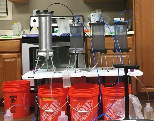
Figure 2: Example of sample filtering in the field.
Data Access
These data are available through the Oak Ridge National Laboratory (ORNL) Distributed Active Archive Center (DAAC).
Delta-X: Bed and Suspended Sediment Grain Size, MRD, LA, USA, 2019-2021, V3
Contact for Data Center Access Information:
- E-mail: uso@daac.ornl.gov
- Telephone: +1 (865) 241-3952
References
Castaneda, E., A.I. Christensen, M. Simard, D.J. Jensen, R. Twilley, and R. Lane. 2020. Pre-Delta-X: Total Suspended Solids of Surface Water across MRD, LA, USA, 2015-2016. ORNL DAAC, Oak Ridge, Tennessee, USA. https://doi.org/10.3334/ORNLDAAC/1802.
Malvern Panalytical. 2024. Mastersizer User Guide. https://www.malvernpanalytical.com
Nghiem, J., G. Salter, and M.P. Lamb. 2022. Delta-X: Bed and Suspended Sediment Grain Size, Wax Lake Delta, LA, USA, 2021. ORNL DAAC, Oak Ridge, Tennessee, USA. https://doi.org/10.3334/ORNLDAAC/2061
Nghiem, J., G. Salter, and M.P. Lamb. 2023. Delta-X: Bed and Suspended Sediment Grain Size, MRD, LA, USA, 2021, Version 2. ORNL DAAC, Oak Ridge, Tennessee, USA. https://doi.org/10.3334/ORNLDAAC/2135
Özer, M., M. Orhan, and N.S. Isik. 2010. Effect of particle optical properties on size distribution of soils obtained by laser diffraction. Environmental & Engineering Geoscience 16:163-173. https://doi.org/10.2113/gseegeosci.16.2.163
Rawle, A.F. 2015. Best practice in laser diffraction–a robustness study of the optical properties of silica. Procedia engineering 102:182–189, https://doi.org/10.1016/j.proeng.2015.01.124
Dataset Revisions
| Version | Release Date | Revision Notes |
|---|---|---|
| 3.0 | 2025-01-28 | Additional data were added. For this Version 3, grain size distribution measurements were reprocessed with optimized optical properties (see Data Acquisition, Materials, and Methods) to improve the accuracy of measurements in Version 2. |
| 2.0 | 2023-03-23 | An error in Version 1 of the Spring 2021 file was introduced during processing by ORNL DAAC, which caused some 'date_time' values to be associated with incorrect rows of data. This error was corrected in Version 2. Version 2 includes the initial release of Fall 2021 data. |
| 1.0 | 2022-09-23 | Initial release of the Spring 2021 data file. |