Documentation Revision Date: 2024-09-10
Dataset Version: 1
Summary
The input data and model code are provided in one compressed Zip (.zip) file. When extracted from the Zip archive, the input data are provided in comma-separated values (CSV) format and model code are Python (.py) files. In addition, there are two files with instructions on installing and running the code provided in PDF format. There are no output files provided in this dataset.
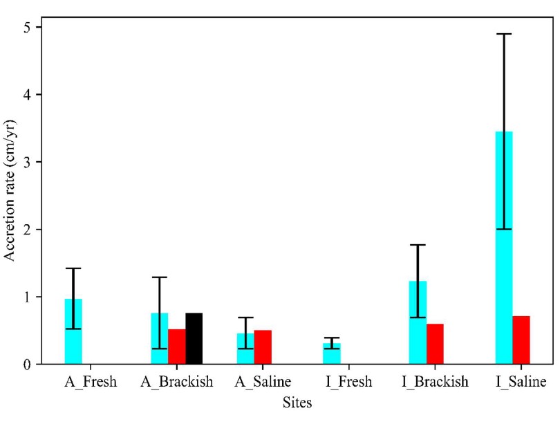
Figure 1. Simulated soil accretion rates based on NUMAR unit mode for each of six sites (blue bar) in Mississippi River Delta compared to the 137-Cs measurements (red bars - unpublished data from Twilley's lab; black bar from Baustian et al. (2021)).
Citation
Twilley, R., P. Biswas, A. Rovai, A.L. Christensen, A.F. Cassaway, I.A. Vargas-Lopez, and S. Kameshwar. 2024. Delta-X: NUMAR Predictive Model for Marsh Accretion Rates and Chemical Properties. ORNL DAAC, Oak Ridge, Tennessee, USA. https://doi.org/10.3334/ORNLDAAC/2354
Table of Contents
- Dataset Overview
- Data Characteristics
- Application and Derivation
- Quality Assessment
- Data Acquisition, Materials, and Methods
- Data Access
- References
Dataset Overview
This dataset provides input data and model code to run the Marsh Accretion Rates (NUMAR) process model used to predict soil accretion rates and chemical properties for marsh sites in the Mississippi River Delta. NUMAR is a modification of the NUMAN model by Chen and Twilley (1999) that was developed for mangrove environments. This dataset provides Python code, input data in comma separated values (CSV) format, and documentation for installing and running the model in Portable Document Format (PDF).
Project: Delta-X
The Delta-X mission is a 5-year NASA Earth Venture Suborbital-3 mission to study the Mississippi River Delta in the United States, which is growing and sinking in different areas. River deltas and their wetlands are drowning as a result of sea level rise and reduced sediment inputs. The Delta-X mission will determine which parts will survive and continue to grow, and which parts will be lost. Delta-X begins with airborne and in situ data acquisition and carries through data analysis, model integration, and validation to predict the extent and spatial patterns of future deltaic land loss or gain.
Acknowledgement:
This program was funded under the NASA Earth Venture Suborbital-3 Program (grant NNH17ZDA001N-EVS3).
Data Characteristics
Spatial Coverage: Atchafalaya and Terrebonne Basins, southern coast of Louisiana, USA
Site Boundaries: Latitude and longitude are given in decimal degrees.
| Site | Westernmost Longitude | Easternmost Longitude | Northernmost Latitude | Southernmost Latitude |
| Atchafalaya and Terrebonne Basins | -91.86 | -90.19 | 29.76 | 28.72 |
Data File Information
This dataset includes three files: two files in Portable Document Format (.pdf) and one compressed zip archive (.zip).
NUMAR_Instruction_Manual.pdf file provides instructions for installing and running the model code.
NUMAR_documentation.pdf includes additional details pertaining to input data, model behavior, and sample outputs.
NUMAR_model.zip holds input data and model code are provided in one compressed Zip (.zip) file:
When extracted from the zip archive, the input data are in comma separated values (.csv) format (Tables 1-6), and the model code consists of Python (.py) files.
Input data and variables
Table 1: Variables in bo_bi_input_file.csv: input for calibrating self-packing density of organic (bo) and inorganic (bi) matter
| Variable | Unit | Description |
|---|---|---|
| basin | - | Name of the basin |
| site | - | Name of the site |
| depth | g g−1 | Corresponding soil depth (set to the midpoint of each soil cohort segment) |
| OM* | g g−1 | Organic matter concentration |
| IM* | g g−1 | Inorganic matter concentration |
| BD* | g cm−3 | Corresponding bulk density, based on average at each site using all samplings at specified soil depth segments such as 0-10, 10-20, ...) |
Table 2: Variables in bd_comp_graph.csv
| Variable | Units | Description |
|---|---|---|
| site | - | Name of the site |
| depth | cm | Soil depth |
| bo | g cm−3 | Self-packing density of organic matter (calibrated) |
| bi | g cm−3 | Self-packing density of inorganic matter (calibrated) |
| OM* | g.g−1 | Organic matter concentration |
| IM* | g g−1 | Inorganic matter concentration |
| measured bd* | g cm−3 | Measured bulk density in the field |
| modeled bd | g cm−3 | Calculated BD using the calibrated bo and bi |
Asterisks (*) in Tables 1 and 2 denote data from Castañeda-Moya and Solohin (2023b). For each soil depth segment (0-10 cm, 10-20 cm, etc.), average soil properties from the source and depth were assigned to the depth mid-point for convenience.
Table 3: Variables in grouped_data_biomass.csv
| Variable | Units | Description |
|---|---|---|
| basin | - | Name of the basin |
| site | - | Name of the site |
| hydrogeomorphic_zone | Hydrogeomorphic zone | |
| depth | cm | Soil depth |
| biomass | g cm−2 | Marsh plant belowground root biomass |
Note: The belowground biomass value in Castañeda-Moya and Solohin (2023a) is in g m-2 and is expressed as total biomass for each 10-cm depth interval. For NUMAR, those values were converted to g cm-2 to be consistent with NUMAR code generating the root biomass at the surface in g cm-2 and root attenuation rate in cm-1.
Table 4: Variables in site_parameters.csv and site_parameters_root_turnover.csv.
| Variable | Units | Description | Source |
|---|---|---|---|
| si | g cm−2 yr-1 | Inorganic matter deposition rate on the soil surface | Cassaway et al. (2024); Twilley et al. (2023) |
| oms | g cm−2 yr-1 | Organic matter deposition rate on the soil surface | Cassaway et al. (2024); Twilley et al. (2023) |
| b0 | g cm−3 | Self-packing density of organic matter | Estimated from soil property data from Castañeda-Moya and Solohin (2023) |
| bi | g cm−3 | Self-packing density of inorganic matter | Estimated from soil property data from Castañeda-Moya and Solohin (2023) |
| c0 | g g−1 | Lignin content in the surface deposit | Fontenot (2022) |
| c1 | g g−1 | Ash content in the root biomass | Fontenot (2022) |
| c2 | g g−1 | Cellulose content in the surface deposit | Considered negligible. No data available |
| c4 | g g−1 | Cellulose content in the root biomass | Wilson (1985) |
| fc1 | g g−1 | Lignin content in the root biomass | Fontenot (2022) |
| kb | yr−1 | Belowground decomposition rate of labile organic matter | Fontenot (2022) |
| kc | yr−1 | Cellulose decomposition rate | Means et al. (1985) |
| kl | yr−1 | Lignin decomposition rate | Means et al. (1985) |
| kr | yr−1 | Root turnover rate | Estimated (see model implementation section |
| r0 | g cm-2 | Root biomass at the surface | Determined from Castañeda-Moya and Solohin (2023a) |
| e |
cm-1 |
Root attenuation rate | Determined from Castañeda-Moya and Solohin (2023a) |
Note: The file site_parameters_root_turnover.csv provides input for varying_kr.py to create file to calibrate root turnover. This file lacks the kr field.
Table 5: Variables in Target_om.csv
| Variable | Units | Description |
|---|---|---|
| Site | - | Name of the site |
| Target_OM | percent | Average organic matter for target site up to 50 cm soil depth in percent dry mass. Data analyzed from Castañeda-Moya and Solohin (2023b) |
Table 6: For random NUMAR input file (site_parameters_random.csv), there are four additional columns. Average COV for each parameter was considered and applied to all sites):
| Variable | Units | Description | Source |
|---|---|---|---|
| si_std | g cm-2 yr-1 | Average standard deviation of si | Cassaway et al.(2024), Twilley et al. (2023) |
| oms_std | g cm-2 yr-1 | Average standard deviation of oms | Cassaway et al.(2024), Twilley et al. (2023) |
| fc1_std | g g−1 | Average standard deviation of fc1 | Cassaway et al.(2024), Twilley et al. (2023) |
| r0_std | g cm-2 | Average standard deviation of r0 | Determined from Castañeda-Moya and Solohin (2023a) |
Application and Derivation
River deltas and their wetlands are drowning as a result of sea level rise and reduced sediment inputs. The Delta-X mission will determine which parts will survive and continue to grow, and which parts will be lost. Delta-X begins with airborne and in situ data acquisition and carries through data analysis, model integration, and validation to predict the extent and spatial patterns of future deltaic land loss or gain.
Quality Assessment
Model predictions were compared to in situ rates at six field sites.
Data Acquisition, Materials, and Methods
Model Implementation
Tests were conducted using NUMAR at six different marsh sites situated in both active (Atchafalaya Basin) and inactive (Terrebonne Basin) delta basins, each with varying levels of salinity from fresh to brackish to saline. The active sites included CRMS 0479 (fresh), CRMS 0399 (brackish), and CRMS 0322 (saline), while the inactive basin sites were CRMS 0294 (fresh), CRMS 0396 (brackish), and CRMS 0421 (saline).
Refer to the data file NUMAR_Instruction_Manual.pdf for detailed instructions on running the NUMAR code.
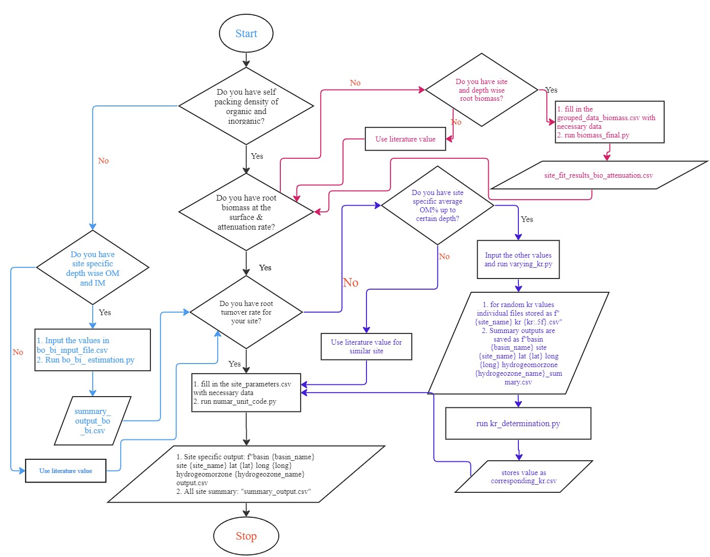
Figure 2. Flow chart for NUMAR model run.
Steps followed
Step 1. Determine self-packing density of organic and inorganic matter. Soil properties (Castañeda-Moya and Solohin, 2023b) such as bulk density (BD), organic fraction, inorganic fraction up to 50 cm depth were available for different sites and used to calculate the self-packing density of organic and inorganic matter through optimization.
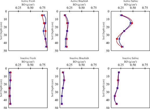
Figure 3. Field observations (red) of bulk density (BD) with simulated BD (blue) at different depths and sites.
Step 2. Estimate root biomass at the surface and attenuation rate. Use optimization through non-linear regression (Levenberg-Marquardt algorithm, see details at Scipy.Optimize.Least_squares — SciPy v1.12.0 Manual) to determine best fitting root biomass at the surface and root attenuation rate for sites.
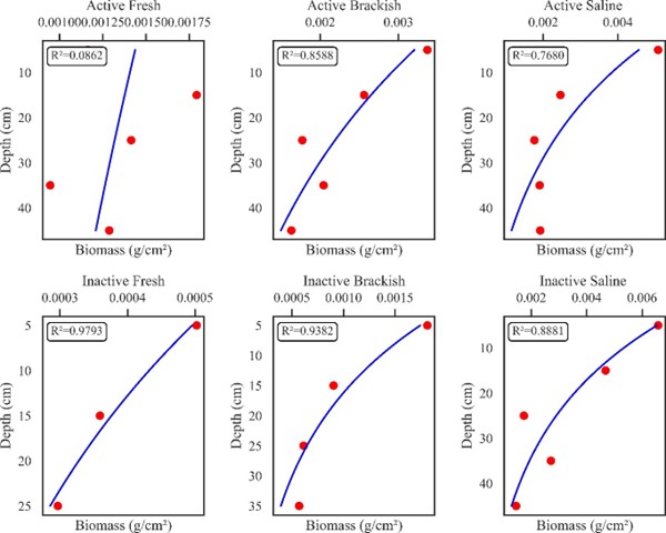
Figure 4. Measured root biomass at the surface and root attenuation rate from mentioned datasets. Blue lines are simulated root biomass profile and red dots are field measurements.
Step 3. Determine root turnover rate (kr) for the site. Root turnover rate was determined by drawing random values for kr from a uniform distribution [0.04,3.22] then using NUMAR to calculate average percent organic matter to 50 cm depth. The kr value that provided the percent organic matter closest to the target value was selected as the kr for that site.
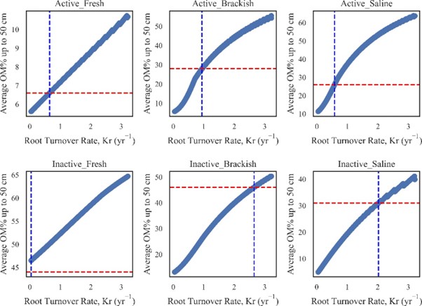
Figure 5. Estimating root turnover from available parameters. Red dotted lines are target organic matter percent up to 50 cm depth. Blue dotted lines are corresponding root turnover.
Step 4. Unit NUMAR using fixed input values: Once all the values are estimated, these are fed to the NUMAR model, and it does the calculation and stores the output data.
Step 5. Randomized unit NUMAR: To observe the site variability, selected parameters (si, oms, kr, r0, fc1) were assigned random values. In this study, si, oms, r0, and fc1 were assigned truncated normal probability distributions. Following expert elicitation, kr was varied uniformly within ±50% to reflect uncertainty in outcomes. NUMAR stores data for all random events and gives output.
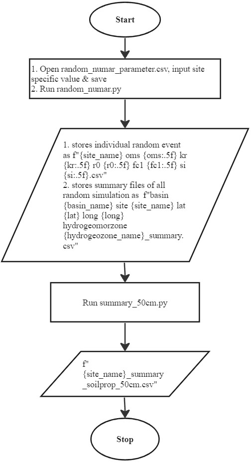
Figure 6. Work flow for NUMAR operation with randomized input values.
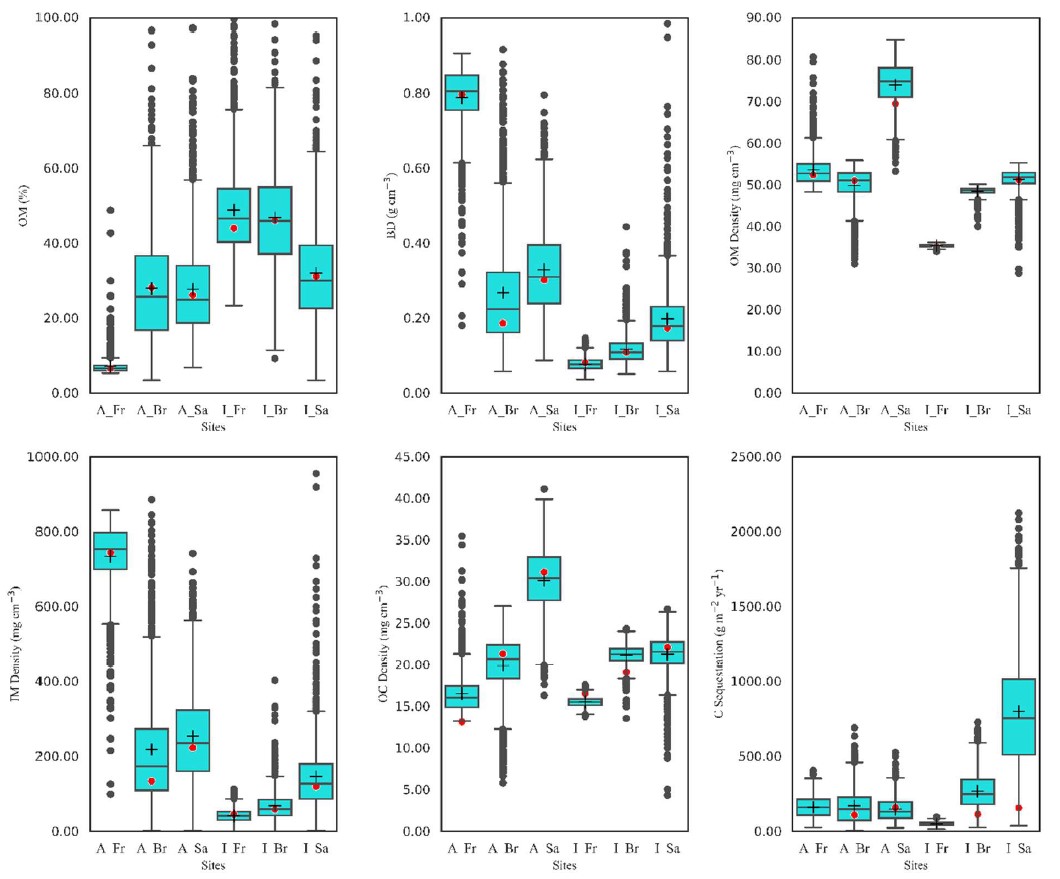
Figure 7. Distribution of soil properties simulated using NUMAR based on site conditions (box plots) compared with field observations (red dots). The six sites include the following: two delta basins (A = Active Basin, I = Inactive Basin) with each of three types of marshes based on salinity (Fr = Fresh, Br = Brackish, and Sa = Saline).
Data Access
These data are available through the Oak Ridge National Laboratory (ORNL) Distributed Active Archive Center (DAAC).
Delta-X: NUMAR Predictive Model for Marsh Accretion Rates and Chemical Properties
Contact for Data Center Access Information:
- E-mail: uso@daac.ornl.gov
- Telephone: +1 (865) 241-3952
References
Baustian, M.M., C.L. Stagg, C.L. Perry, L.C. Moss, and T.J.B. Carruthers. 2021. Long-term carbon sinks in marsh soils of coastal Louisiana are at risk to wetland loss. Journal of Geophysical Research: Biogeosciences 126:e2020JG005832. https://doi.org/10.1029/2020JG005832
Cassaway, A.F., Twilley, R.R., Rovai, A.S., Snedden, G., 2024. Patterns of marsh surface accretion rates along salinity and hydroperiod gradients between active and inactive coastal deltaic floodplains. Estuar Coast Shelf Sci in review.
Castañeda-Moya, E., and E. Solohin. 2023a. Delta-X: Belowground Biomass and Necromass across Wetlands, MRD, LA, USA, 2021, V2. ORNL DAAC, Oak Ridge, Tennessee, USA. https://doi.org/10.3334/ORNLDAAC/2238
Castañeda-Moya, E., and E. Solohin. 2023b. Delta-X: Soil Properties for Herbaceous Wetlands, MRD, Louisiana, 2021, V3. https://doi.org/10.3334/ORNLDAAC/2239
Castañeda-Moya, E., and E. Solohin. 2023. Delta-X: Aboveground Biomass and Necromass across Wetlands, MRD, Louisiana, 2021, V2. https://doi.org/10.3334/ORNLDAAC/2237
Cortese, L., and S.Fagherazzi. 2023. Delta-X: Delft3D Broad-Scale Sediment Model, Terrebonne Basin, MRD, Louisiana, USA. https://doi.org/10.3334/ORNLDAAC/2301
Cortese, L., and S. Fagherazzi. 2022. Fetch and distance from the bay control accretion and erosion patterns in Terrebonne marshes (Louisiana, USA). Earth Surface Processes and Landforms 47:1455–1465. https://doi.org/10.1002/esp.5327
Fontenot, A. 2022. Wetland Soil Development Along Salinity and Hydrogeomorphic Gradients in Active and Inactive Deltaic Basins of Coastal Louisiana [Master of Science, Louisiana State University and Agricultural and Mechanical College]. https://doi.org/10.31390/gradschool_theses.5622
Jensen, D.J., E. Castañeda-Moya, E. Solohin, A. Rovai, D.R. Thompson, and M. Simard. 2022. Delta-X: Herbaceous Aboveground Biomass from AVIRIS-NG, MRD, Louisiana, USA, 2021. ORNL DAAC, Oak Ridge, Tennessee, USA. https://doi.org/10.3334/ORNLDAAC/2107
Means, J. E., K. Cromack Jr, and P.C. MacMillan. 1985. Comparison of decomposition models using wood density of Douglas-fir logs. Canadian Journal of Forest Research 15:1092–1098. https://doi.org/10.1139/x85-178
Nyman, J.A., C.S. Reid, C.E. Sasser, J. Linscombe, S.B. Hartley, B.R. Couvillion, and R.K. Villani. 2022. Vegetation Types in Coastal Louisiana in 2021. US Geological Survey data release. https://doi.org/10.5066/P9URYLMS
scipy.optimize.least_squares—SciPy v1.12.0 Manual. (n.d.). Retrieved March 22, 2024, from https://docs.scipy.org/doc/scipy/reference/generated/scipy.optimize.least_squares.html
Twilley, R., Fontenot-Cassaway, A., Rovai, A., 2023. Delta-X: Feldspar Sediment Accretion Measurements, MRD, LA, USA, 2019-2023, Version 3. https://doi.org/10.3334/ORNLDAAC/2290
Wilson, J.O. 1985. Decomposition of [14C] Lignocelluloses of Spartina alterniflora and a Comparison with Field Experiments. Applied and Environmental Microbiology 49:478–484. https://doi.org/10.1128/aem.49.3.478-484.1985