Documentation Revision Date: 2023-01-05
Dataset Version: 1
Summary
Delta-X conducted a joint airborne and field campaign in the Mississippi River Delta during Spring and Fall 2021. The Delta-X campaign conducted airborne (remote sensing) and field (in situ) measurements to observe hydrology, water quality (e.g., total suspended solids (TSS)) and vegetation structure.
There are 21 data files in comma-separated values format (.csv) with this dataset.
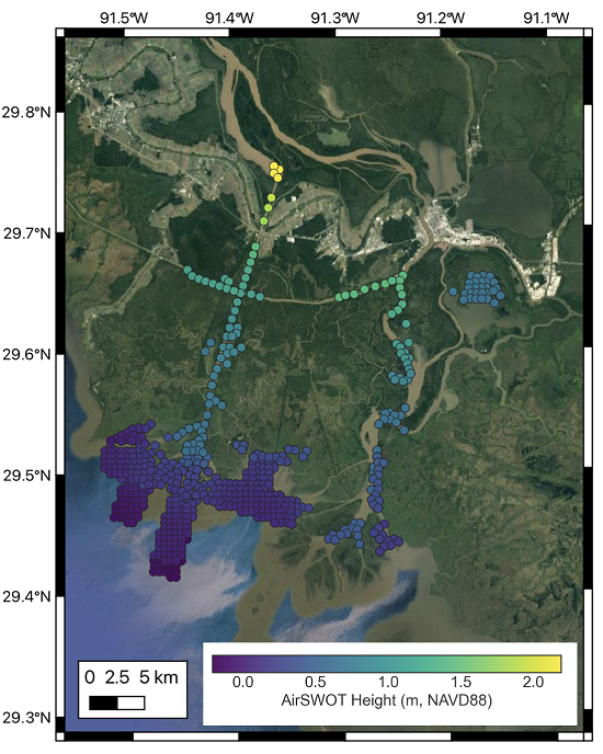
Figure 1. AirSWOT L3 water surface elevations collected on April 1, 2021 over the Atchafalaya Basin. Each point is colored based on its elevation with respect to the NAVD88 vertical datum (GEOID12B), as shown in the colorbar.
Citation
Denbina, M.W., M. Simard, and E. Rodriguez. 2022. Delta-X: AirSWOT L3 Water Surface Elevations, MRD, Louisiana, 2021. ORNL DAAC, Oak Ridge, Tennessee, USA. https://doi.org/10.3334/ORNLDAAC/2133
Table of Contents
- Dataset Overview
- Data Characteristics
- Application and Derivation
- Quality Assessment
- Data Acquisition, Materials, and Methods
- Data Access
- References
Dataset Overview
This dataset contains water surface elevations generated from the AirSWOT data collected during the Spring and Fall 2021 Delta-X campaigns over the Atchafalaya and Terrebonne basins in Louisiana, USA. AirSWOT uses near-nadir wide-swath Ka-band radar interferometry to measure water-surface elevation and produce continuous gridded elevation data. The data were created by masking land areas out of the AirSWOT Level 2 products, then filtering and averaging to the AirSWOT heights to produce water surface elevations at selected points throughout the scene. The AirSWOT elevation data are useful for calibrating elevation and slopes along the main channels, as well as tying observations to open ocean tidal conditions. AirSWOT performance in the floodplain was limited by the presence of vegetation and the very small slope characteristic of two dimensional floodplain discharge. Therefore, the bulk of the AirSWOT data collections were targeted at the larger channels, since the channel discharge provides the necessary boundary conditions for potential overflow to islands and floodplains.
The AirSWOT instrument suffered from small phase drifts creating potential slope artifacts in the cross-track direction. To correct the phase-drift artifacts, the flight pattern was designed to include crossovers that were used to make global adjustments and estimate phase drifts when producing the L2 and L3 products.
Project: Delta-X
The Delta-X mission is a 5-year NASA Earth Venture Suborbital-3 mission to study the Mississippi River Delta in the United States, which is growing and sinking in different areas. River deltas and their wetlands are drowning as a result of sea level rise and reduced sediment inputs. The Delta-X mission will determine which parts will survive and continue to grow, and which parts will be lost. Delta-X begins with airborne and in situ data acquisition and carries through data analysis, model integration, and validation to predict the extent and spatial patterns of future deltaic land loss or gain.
Related Datasets
Denbina, M.W., M. Simard, and E. Rodriguez. 2022. Delta-X: AirSWOT L2 Geocoded Water Surface Elevation, MRD, Louisiana, 2021, Version 2. ORNL DAAC, Oak Ridge, Tennessee, USA. https://doi.org/10.3334/ORNLDAAC/2128
- Contains L2 AirSWOT water elevation products from the Delta-X 2021 Spring and Fall Campaigns.
Denbina, M.W., M. Simard, E. Rodriguez, X. Wu, and C. Michailovsky. 2021. Pre-Delta-X: L2 AirSWOT Water Surface Elevations, Atchafalaya Basin, LA, USA, 2016. ORNL DAAC, Oak Ridge, Tennessee, USA. https://doi.org/10.3334/ORNLDAAC/1818.
- Contains L2 AirSWOT products from the Pre-Delta-X Spring 2015 deployment.
Denbina, M.W., M. Simard, and E. Rodriguez. 2021. Delta-X: AirSWOT Level 1b Interferogram Products across MRD, LA, USA, 2021. ORNL DAAC, Oak Ridge, Tennessee, USA. https://doi.org/10.3334/ORNLDAAC/1996.
- Contains L1b AirSWOT products from the Delta-X 2021 deployment
Acknowledgement
This work was supported by NASA's Earth Venture Suborbital-3 (grant NNH17ZDA001N-EVS3: Delta-X) program and the Jet Propulsion Laboratory R&TD F17-19 program.
Data Characteristics
Spatial Coverage: Atchafalaya and Terrebonne Basins, southern coast of Louisiana, USA
Spatial Resolution: Multiple points
Temporal Coverage:
Spring Flights: 2021-03-26, 2021-03-27, 2021-04-01, 2021-04-02, 2021-04-05, 2021-04-06, 2021-04-07, 2021-04-12, 2021-04-16, and 2021-04-18.
Fall Flights: 2021-08-21, 2021-08-22, 2021-08-23, 2021-08-24, 2021-09-01, 2021-09-03, 2021-09-04, 2021-09-05, 2021-09-07, 2021-09-11, and 2021-09-12
Temporal Resolution: AirSWOT elevations are averaged in segments with area ranging between 0.1 - 1 km2. The segment area varies depending on the water mask and shape of the channels, as segments are masked to only include water.
Site Boundaries: Latitude and longitude are given in decimal degrees.
| Site | Westernmost Longitude | Easternmost Longitude | Northernmost Latitude | Southernmost Latitude |
|---|---|---|---|---|
| Atchafalaya and Terrebonne basins, Louisiana, US | -91.5335 | -91.2322 | 29.75289 | 29.07163 |
Data File Information
There are 21 data files in comma-separated values format (.csv) with this dataset.
NOTE: The data for September 1 and September 5, 2021 were impacted by poor flight conditions and have a higher noise level and other anomalous errors compared to the data collected on other dates. As part of AirSWOT L2 validation, water levels as measured by AirSWOT are compared to in situ station data with expected mean absolute error around 10 cm or less. However, the data acquired on September 1 and September 5, 2021, did not meet these criteria. Users should take cautioned when using the data from these dates.
Data file naming convention
The files are named basin_date_L3.csv, where
- basin specifies the basin of the data, either “atcha” (Atchafalaya), wterre” (West Terrebonne), or “eterre” (East Terrebonne),
- date is the date when data were collected, in the form YYYYMMDD, and
- L3 indicates the Level 3 data product.
For example, the flight on April 1, 2021 has the filename: Atcha_20210401_L3.csv
Table 1. Variables in the data files.
| Variable | Units | Description |
|---|---|---|
| flight_line_id | String identifying the flight line of the data point by the date and time of it was flown in the form YYYYMMDDHHMMSS (four-digit year, month, day, hour, minute, second). | |
| basin_id | String identifying the basin of the data point, either “ATCHA” for Atchafalaya, or “TERRE” for Terrebonne. | |
| channel_id | String identifying the channel of the data point, either “WLO” (Wax Lake Outlet), “ATCH” (Atchafalaya River), “ICWW” (Intracoastal Waterway), “HOUMA” (Houma Navigational Canal), or “N/A” if the point is not in one of the channels listed above. | |
| date | YYYY-MM-DD | Date the data were acquired, in UTC. |
| time | hh:mm:ss | Approximate time the data were acquired, in hours:minutes:seconds UTC. |
| utc_time | s | Equivalent to the “time” field, but contains the UTC time in seconds of day rather than formatted as hours:minutes:seconds. |
| coord_x | m | UTM easting coordinate of the point, in UTM Zone 15 North. |
| coord_y | m | UTM northing coordinate, in UTM Zone 15 North. |
| longitude | decimal degrees | Longitude of the point, in decimal degrees, with respect to the WGS84 ellipsoid. |
| latitude | decimal degrees | Latitude of the point, in decimal degrees, with respect to the WGS84 ellipsoid. |
| channel_dist | m | Distance along the channel with respect to the starting point of the channel, which is the Westernmost point of the ICWW, or the most upstream point for the other channels. For points that are not part of a channel (channel_id = “N/A”), channel_dist will be zero. |
| water_surface_elevation_WGS84 | m | Water surface elevation estimated by AirSWOT, with respect to the WGS84 ellipsoid. |
| water_surface_elevation_NAVD88 | m | Water surface elevation estimated by AirSWOT, with respect to NAVD88 (GEOID12B). |
| water_surface_elevation_uncertainty | m | Estimated uncertainty (1-sigma standard deviation) of the AirSWOT water surface elevation, in meters. |
| water_area | km2 | The water area around the node that was averaged in the AirSWOT height data, in square kilometers. This value depends on the spatial coverage of the surrounding water, and whether that water produced enough backscatter to be observed by AirSWOT. |
Application and Derivation
AirSWOT is used to measure open water surface elevation (Altenau et al., 2017; Altenau et al., 2019), which serves to calibrate and validate hydrodynamic models and estimate river discharge (Pitcher et al., 2019; Tuozzolo et al., 2019).
Quality Assessment
AirSWOT produces continuous gridded elevation data. On a pixel basis, elevation error was dominated by random noise, and contiguous pixels along a river channel were averaged to reduce measurement noise. Assuming a total averaging area of 1 km2, the height noise was less than 10 cm for the Pre-Delta-X L2 products after final phase calibration. Validation of Delta-X data products is ongoing.
Data quality of the AirSWOT water level products was assessed by comparison with data from in situ water level gauges at locations throughout the study area. The calibration and global adjustment analysis estimated the phase drift rate to make global calibration adjustments based on cross-over flight lines.
In addition, an estimated height uncertainty product is included in this L3 product. The variable “water_surface_elevation_uncertainty” contains an estimate of the 1-sigma standard deviation of the AirSWOT elevation for each point in the file. This uncertainty estimate is based on the random noise in the AirSWOT data and does not account for systematic or other large-scale errors.
Note that the data for September 1 and September 5, 2021 were impacted by poor flight conditions and have a higher noise level and other anomalous errors compared to the data collected on other dates. As part of AirSWOT L2 validation, water levels as measured by AirSWOT are compared to in situ station data with expected mean absolute error around 10 cm or less. However, the data acquired on September 1 and September 5, 2021, did not meet these criteria. Users should take caution when using the data from these dates.
Data Acquisition, Materials, and Methods
AirSWOT produces data products in multiple modes and employs cross-track and along-track interferometry to both estimate the height of the water surface and compensate for the motion of the water scatterers (Altenau et al., 2017). The delivered products are from mode “m0m”, which stands for mode 0 with motion compensation, and represents the main cross-track outer swath mode of AirSWOT after motion compensation has been applied to the interferometric phase. These L3 data were created by masking land areas out of the AirSWOT Level 2 products, then filtering and averaging to the AirSWOT heights to produce water surface elevations at selected points throughout the scene
AirSWOT performance in the floodplain was limited by the presence of vegetation and the very small slope characteristic of two dimensional floodplain discharge. Therefore, the bulk of the AirSWOT data collections were targeted at the larger channels, since the channel discharge provides the necessary boundary conditions for potential overflow to islands and floodplains. The AirSWOT instrument suffered from small phase drifts creating potential slope artifacts in the cross-track direction. To correct the phase-drift artifacts, the flight pattern was designed to include crossovers that were used to make global adjustments and estimate phase drifts when producing the L2 and L3 products.
The phase drift compensation, with in situ water level measurements, was used to calibrate previous AirSWOT water surface level measurements from the Pre-Delta-X campaign (Denbina et al., 2019). The integration of in situ measurements into the AirSWOT processing was novel to the Pre-Delta-X campaign. In situ data were incorporated in the phase calibration procedure because the standard AirSWOT phase calibration could be adversely affected by vegetated areas such as wetlands (which cover a significant portion of the Delta-X study area) (see Section 5 of Denbina, 2018). For the 2015 AirSWOT campaign released data, and this Delta-X delivery, only outer swath products were included, and lines were processed using version 1.3 of the AirSWOT processing code.
Data Access
These data are available through the Oak Ridge National Laboratory (ORNL) Distributed Active Archive Center (DAAC).
Delta-X: AirSWOT L3 Water Surface Elevations, MRD, Louisiana, 2021
Contact for Data Center Access Information:
- E-mail: uso@daac.ornl.gov
- Telephone: +1 (865) 241-3952
References
Altenau, E.H., T.M. Pavelsky, D. Moller, C. Lion, L.H. Pitcher, G.H. Allen, P.D. Bates, S. Calmant, M. Durand, and L.C. Smith. 2017. AirSWOT measurements of river water surface elevation and slope: Tanana River, AK. Geophysical Research Letters 44:181–189. https://doi.org/10.1002/2016GL071577
Altenau, E.H., T.M. Pavelsky, D. Moller., L.H. Pitcher, P.D. Bates, M.T. Durand, and L.C. Smith. 2019. Temporal variations in river water surface elevation and slope captured by AirSWOT. Remote Sensing of Environment 224:304- 316. https://doi.org/10.1016/j.rse.2019.02.002
Denbina, M.W., M. Simard, and E. Rodriguez. 2022. Delta-X: AirSWOT L2 Geocoded Water Surface Elevation, MRD, Louisiana, 2021, Version 2. ORNL DAAC, Oak Ridge, Tennessee, USA. https://doi.org/10.3334/ORNLDAAC/2128
Denbina, M.W., M. Simard, E. Rodriguez, X. Wu, and C. Michailovsky. 2021. Pre-Delta-X: L2 AirSWOT Water Surface Elevations, Atchafalaya Basin, LA, USA, 2016. ORNL DAAC, Oak Ridge, Tennessee, USA. https://doi.org/10.3334/ORNLDAAC/1818.
Denbina, M.W., M. Simard, and E. Rodriguez. 2021. Delta-X: AirSWOT Level 1b Interferogram Products across MRD, LA, USA, 2021. ORNL DAAC, Oak Ridge, Tennessee, USA. https://doi.org/10.3334/ORNLDAAC/1996.
Denbina, M., M. Simard, E. Rodriguez, X. Wu, A. Chen, and T. Pavelsky. 2019. Mapping water surface elevation and slope in the Mississippi River Delta Using the AirSWOT Ka-band interferometric synthetic aperture radar. Remote Sensing 11:2739. https://doi.org/10.3390/rs11232739
Pitcher, L.H., T.M. Pavelsky, L.C. Smith., D.K. Moller, E.H. Altenau, G.H. Allen, C. Lion, D. Butman, S.W. Cooley, J.V. Fayne, and M. Bertram. 2019. AirSWOT InSAR mapping of surface water elevations and hydraulic gradients across the Yukon Flats Basin, Alaska. Water Resources Research 55:937–953. https://doi.org/10.1029/2018WR023274
Tuozzolo, S., G. Lind, B. Overstreet, J. Mangano, M. Fonstad, M. Hagemann, R.P.M. Frasson, K. Larnier, P.A. Garambois, J. Monnier, and M. Durand. 2019. Estimating river discharge with swath altimetry: a proof of concept using AirSWOT observations. Geophysical Research Letters 46:1459–1466. https://doi.org/10.1029/2018GL08077