Documentation Revision Date: 2022-10-06
Dataset Version: 2
Summary
There are 43 netCDF data files and one file in comma-separated values (.csv) format with this dataset.
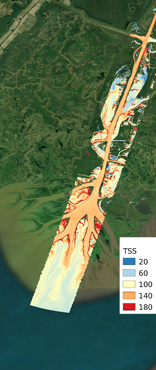
Figure 1. Map of total suspended solids (TSS) in the Wax Lake Delta, Terrebonne basin of the Mississippi River Delta of coastal Louisiana. TSS was estimated from AVIRIS-NG imagery using a regression model derived from in-situ measurements of surface reflectance and TSS.
Citation
Fichot, C.G., and J. Harringmeyer. 2022. Delta-X: AVIRIS-NG L3-derived Water Quality, TSS, and Turbidity, MRD, LA 2021, V2. ORNL DAAC, Oak Ridge, Tennessee, USA. https://doi.org/10.3334/ORNLDAAC/2112
Table of Contents
- Dataset Overview
- Data Characteristics
- Application and Derivation
- Quality Assessment
- Data Acquisition, Materials, and Methods
- Data Access
- References
- Dataset Revisions
Dataset Overview
This dataset includes estimates of total suspended solids (TSS) concentration and turbidity for waters of the Atchafalaya River and Terrebonne Basins of the Mississippi River Delta (MRD) in coastal Louisiana. Estimates were derived from Level 2 (L2) BRDF-corrected imagery from the NASA's Next Generation Airborne Visible Infrared Imaging Spectrometer (AVIRIS-NG). AVIRIS-NG imagery was collected on March 27 to April 6 (spring) and August 20-25 (fall), 2021, as part of the 2021 Delta-X campaign. Algorithms for TSS and turbidity estimation were developed using in-situ remote-sensing reflectance measured at field sampling stations paired with in-situ measures of turbidity from a water quality probe and TSS from water samples. Using the in-situ data, a partial least squares regression (PLSR) model was developed for each AVIRIS-NG wavelength. A subset of the in-situ data, collected during relatively clear AVIRIS-NG overflights, was held out to validate the PLSR model. The PLSR algorithm was then applied to AVIRIS-NG imagery to retrieve TSS and turbidity across the study area. The measurement units for TSS and turbidity estimates are mg L-1 and Nephelometric Turbidity Units (NTU), respectively, and the spatial resolution is 3.8 to 5.4 m as determined by the AVIRIS-NG imagery. The dataset includes binary cloud and master masks. These data quantify the mesoscale (i.e., on the order of 1 ha) patterns of soil accretion that control land loss and gain and predict the resilience of deltaic floodplains under projected relative sea-level rise. Gridded estimates are provided in netCDF format, and regression coefficients are included in a comma-separated values (CSV) file. This is Version 2 of this dataset. All previously released data were updated to the latest available versions.
Project: Delta-X
The Delta-X mission is a 5-year NASA Earth Venture Suborbital-3 mission to study the Mississippi River Delta in the United States, which is growing and sinking in different areas. River deltas and their wetlands are drowning as a result of sea level rise and reduced sediment inputs. The Delta-X mission will determine which parts will survive and continue to grow, and which parts will be lost. Delta-X begins with airborne and in situ data acquisition and carries through data analysis, model integration, and validation to predict the extent and spatial patterns of future deltaic land loss or gain.
Related Datasets
Fichot, C.G., N. Ghosh, J. Harringmeyer, and M. Weiser. 2021a. Delta-X: Total Suspended Solids Concentration across MRD, LA, USA, 2021. ORNL DAAC, Oak Ridge, Tennessee, USA. https://doi.org/10.3334/ORNLDAAC/1991
Fichot, C.G., J. Harringmeyer, and M. Weiser. 2021b. Delta-X: In Situ Water Quality Indicators across MRD, LA, USA, 2021. ORNL DAAC, Oak Ridge, Tennessee, USA. https://doi.org/10.3334/ORNLDAAC/1992
Fichot, C.G., and J. Harringmeyer. 2021c. Delta-X: In Situ Spectral Reflectance of Water Surface at MRD at LA, USA, Spring 2021. ORNL DAAC, Oak Ridge, Tennessee, USA. https://doi.org/10.3334/ORNLDAAC/1994
- These three datasets hold the in-situ data used to develop the TSS and turbidity retrieval algorithms.
Thompson, D.R., D.J. Jensen, J.W. Chapman, M. Simard, and E. Greenberg. 2022. Delta-X: AVIRIS-NG BRDF-Adjusted Surface Reflectance, MRD, LA, 2021. ORNL DAAC, Oak Ridge, Tennessee, USA. https://doi.org/10.3334/ORNLDAAC/2025
- This dataset holds the L2 BRDF-corrected AVIRIS-NG imagery employed to create the included TSS and turbidity maps.
Acknowledgments
This work was supported by NASA's Earth Venture Suborbital-3 (grant NNH17ZDA001N-EVS3: Delta-X) program and the Jet Propulsion Laboratory R&TD F17-19 program.
Data Characteristics
Spatial Coverage: Atchafalaya River and Terrebonne Basins, Louisiana, USA
Spatial Resolution: 3.8 to 5.4 m
Temporal Coverage: 2021-03-27 to 2021-08-25
Temporal Resolution: One-time estimates
Site Boundaries: Latitude and longitude are given in decimal degrees.
|
Site |
Westernmost Longitude |
Easternmost Longitude |
Northernmost Latitude |
Southernmost Latitude |
|---|---|---|---|---|
|
Atchafalaya River and Terrebonne Basins, Louisiana |
-91.4847 |
-90.1774 |
29.8090 |
29.0609 |
Data File Information
There are 43 netCDF files and one file in comma-separated values (.csv) format with this dataset.
The netCDFs contain gridded estimates of total suspended solids (TSS) and turbidity. The naming convention is angYYYYMMDDthhmmss_rfl_brdf_WQ.nc (e.g., ang20210825t153003_rfl_brdf_WQ.nc), where
- YYYYMMDD = date of acquisition in year (YYYY), month (MM), and day (DD)
- hhmmss = start time of acquisition in hour) (hh), minute (mm), and second (ss)
The file DeltaX_WQ_PLSR_Coefficients.csv contains the regression coefficients for the models used for estimating TSS and turbidity from the L2 AVIRIS-NG imagery. Coefficients are listed by AVIRIS-NG band. Bands without a coefficient were not included in the respective TSS or turbidity estimation model.
Table 1. Variables in the NetCDF data files: angYYYYMMDDthhmmss_rfl_brdf_WQ.nc.
| Variable | Units | Description |
|---|---|---|
| latitude | degrees east | Location of measurement pixel |
| longitude | degrees north | Location of measurement pixel |
| TSS_loglog_PLSR7_380_900_nm | mg L-1 | Estimated total suspended solids (TSS) concentration |
| Turbidity_loglog_PLSR7_380_900_nm | FNU | Estimated turbidity in Formazin Nephelometric Units (FNU) |
| Water_Mask | 1 | Binary water mask derived from AVIRIS-NG band ratio (see Methods below): 1 indicates water pixel, 0 indicates non-water pixel |
| Cloud_Mask | 1 | Binary cloud mask derived from AVIRIS-NG band ratio (see Methods below): 1 indicates cloud, pixel 0 indicates non-cloud pixel |
Table 2. Variables in DeltaX_WQ_PLSR_Coefficients.csv
|
Variable |
Units |
Description |
|---|---|---|
|
AVIRIS-NG Band Center |
nm |
Center of wavelengths for each AVIRIS-NG band |
|
TSS Algorithm Coefficients |
1 |
Partial least squares regression coefficients (ßi) for each AVIRIS-NG band used to estimate total suspended solids concentration (mg L-1) |
|
Turbidity Algorithm Coefficients |
1 |
Partial least squares regression coefficients (ßi) for each AVIRIS-NG band used to estimate turbidity in Formazin Nephelometric Units (FNU) |
Application and Derivation
This dataset presents maps of total suspended solids (TSS) and turbidity derived from AVIRIS-NG airborne imagery from the 2021 Delta-X campaign. During the Delta-X field efforts, in-situ above-water measurements of remote-sensing reflectance (Rrs) were collected at sites across the Atchafalaya and Terrebonne basins. These sampling sites spanned large and small channels at locations chosen to cover a representative range of TSS concentration from a variety of hydrodynamic and physical settings typically encountered across this study area. The in-situ data were used to calibrate and validate Delta-X’s algorithms that relate remote-sensing reflectance to TSS concentration and turbidity. The algorithms enable remote estimation of TSS from its influence on the color of surface waters. Algorithms are then applied to atmospherically-corrected AVIRIS-NG imagery (Thompson et al., 2021) on a pixel-by-pixel basis to retrieve estimates of TSS.
Remote-sensing-derived estimates of TSS distribution will be compared to numerical models to calibrate and validate its parameters. The models quantify the mesoscale (i.e., on the order of 1 ha) patterns of soil accretion that control land loss and gain and predict the resilience of deltaic floodplains under projected relative sea-level rise. Understanding and mitigating the impact of the relative sea-level rise on coastal deltas is urgent. If ignored, relative sea-level rise will very soon have devastating consequences on the livelihood of the half-billion people that live in these low-lying coastal regions.
Quality Assessment
Uncertainty was evaluated by comparing water quality parameters retrieved using the partial least squares regression algorithms to field measurements collected near-simultaneously with AVIRIS-NG overflights. Reflectance was extracted from the imagery at matching pixels and used with the regression algorithms to retrieve local, remotely sensed estimates of TSS and turbidity. These validation data allowed comparison of TSS estimates from AVIRIS-NG imagery against near-simultaneous, co-located field measurements. Error statistics for end-to-end retrievals using both spring and fall 2021 field campaign data are presented in Table 3.
Table 3. Validation error statistics
| Parameter (units) | Validation R2 | Mean Absolute Percent Error (MAPE) | Mean Absolute Error (MAE) |
|---|---|---|---|
| Total suspended solids (mg L-1) | 0.92 | 23.5 | 11.4 |
| Turbidity (NTU) | 0.94 | 15.4 | 4.23 |
Data Acquisition, Materials, and Methods
Airborne Imagery and In-situ Measurements
During the 2021 Delta-X field efforts, AVIRIS-NG imagery was collected to produce georeferenced surface reflectance (Rrs ) spectra across the Atchafalaya and Terrebonne Basins. The flight lines were planned to capture variability in total suspended solids (TSS) concentration and care was taken to maintain viewing and solar geometry to minimize sun glint. Field sampling was coordinated so that field measurements were collected simultaneously with imagery (Figure 2). In-situ field measurements of water-quality parameters included turbidity, above-water radiometry (in-situ Rrs), and water sample collection for laboratory analysis of TSS. Some sampling stations did not include water sample collection, and a few stations only included water quality measured with a multi-parameter probe. However, only stations where in-situ Rrs and all water quality parameters were measured were used for algorithm development.
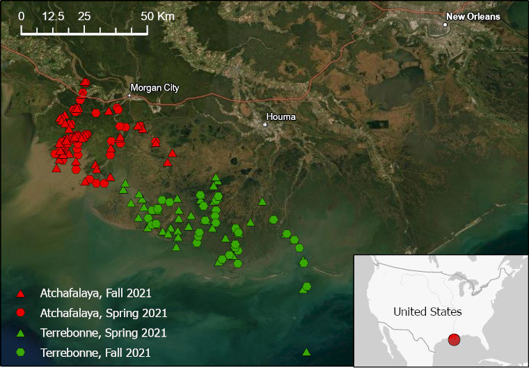
Figure 2. Delta-X 2021 sampling sites for water quality studies labeled by basin and field season.
Algorithm Development and Measurement Procedure
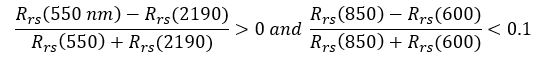
Algorithms were developed using in-situ Rrs, TSS, and turbidity datasets measured at field stations (Fichot et al., 2021a, 2021b, 2021c). Field data from both the spring 2021 and fall 2021 field efforts were used to estimate the coefficients of a partial least squares (PLS) regression that estimated TSS or turbidity from in-situ Rrs in the range from 380-900 nm. TSS and turbidity were retrieved using a log-log transformed PLS regression using the equation:

where β0 is an intercept coefficient and βλ1 to βλi are the coefficients corresponding to in-situ reflectance (λ1...λi) interpolated to the AVIRIS-NG wave bands.
TSS algorithms were calibrated using a fused dataset combining data from the 2021 Delta-X field campaigns with supplementary data from 2010. The supplementary data had analogous measurements of TSS (Epps 2018) and Rrs (Fichot et al., 2014; Verma et al., 2021) measured at field sampling stations during the GulfCarbon campaign in 2010. For turbidity, coefficients were estimated using in-situ Rrs and turbidity measurements from the 2021 Delta-X campaign.
Partial-least-squares regression was conducted using the plsregress function in MatLab, which implements the SIMPLS algorithm. The optimal number of latent variables for the PLS regression was selected using leave-one-out cross-validation, resulting in seven latent variables for the TSS and turbidity algorithms. A variable reduction was then implemented using a variable importance projection (VIP) approach. Wavelengths with VIP scores >1 were included in the final algorithm as predictor variables. Coefficients of the PLS regression algorithms are listed in the DeltaX_WQ_PLSR_Coefficients.csv file by AVIRIS-NG wavelengths. Wavelengths with no entry had VIP <1 and were not included in the model.
Algorithms were then applied to L2 BRDF-corrected AVIRIS-NG imagery collected for Delta-X in 2021 (Thompson et al., 2022). For each L2 AVIRIS-NG image, the TSS and turbidity algorithms were applied on a pixel-wise basis to estimate water quality parameters from the remotely sensed Rrs for each cell. A 3x3 median filter was then applied to each image, to remove any residual salt-and-pepper artifacts (e.g., residual glint) in the retrieved water quality products.
The NetCDF files include water mask and cloud mask layers to exclude dry land pixels and those in which clouds prevented accurate estimation of water quality parameters. The water mask was derived from band ratio thresholds on the AVIRIS-NG imagery as described by Greenberg et al. (2022). Water pixels were identified by ...
 ,
,
otherwise the pixel was non-water.
The cloud mask was derived from band ratio thresholds on the AVIRIS-NG imagery as described by Jensen et al. (2019). Cloud pixels were identified by ...
 ,
,
otherwise the pixel was non-cloud. For some images, an additional buffer around identified clouds may beneficial to remove potential effects of cloud adjacency and cloud shadows before use.
Data Access
These data are available through the Oak Ridge National Laboratory (ORNL) Distributed Active Archive Center (DAAC).
Delta-X: AVIRIS-NG L3-derived Water Quality, TSS, and Turbidity, MRD, LA 2021, V2
Contact for Data Center Access Information:
- E-mail: uso@daac.ornl.gov
- Telephone: +1 (865) 241-3952
References
Epps, S. 2018. The Feasibility of using Inherent Optical Properties and the Apparent Optical Property Remote Sensing Reflectance to estimate Suspended Particulate Matter, Particularly for use in Airborne Hydrographic Surveys. Dissertation, number 1552. University of Southern Mississippi; Hattiesburg, Mississippi, U.S. https://aquila.usm.edu/dissertations/1552
Fichot, C. G., S. E. Lohrenz, and R. Benner. 2014. Pulsed, cross-shelf export of terrigenous dissolved organic carbon to the Gulf of Mexico. Journal of Geophysical Research: Oceans 119:1176–1194. https://doi.org/10.1002/2013JC009424
Fichot, C.G., N. Ghosh, J. Harringmeyer, and M. Weiser. 2021a. Delta-X: Total Suspended Solids Concentration across MRD, LA, USA, 2021. ORNL DAAC, Oak Ridge, Tennessee, USA. https://doi.org/10.3334/ORNLDAAC/1991
Fichot, C.G., J. Harringmeyer, and M. Weiser. 2021b. Delta-X: In Situ Water Quality Indicators across MRD, LA, USA, 2021. ORNL DAAC, Oak Ridge, Tennessee, USA. https://doi.org/10.3334/ORNLDAAC/1992
Fichot, C.G., and J. Harringmeyer. 2021c. Delta-X: In Situ Spectral Reflectance of Water Surface at MRD at LA, USA, Spring 2021. ORNL DAAC, Oak Ridge, Tennessee, USA. https://doi.org/10.3334/ORNLDAAC/1994
Greenberg, E., D.R. Thompson, D.J. Jensen, P.A. Townsend, N. Queally, A. Chlus, C.G. Fichot, J.P. Harringmeyer, and M. Simard. 2022. An improved scheme for correcting remote spectral surface reflectance simultaneously for terrestrial BRDF and water-surface sunglint in coastal environments. Journal of Geophysical Research: Biogeosciences 127:e2021JG006712. https://doi.org/10.1029/2021jg006712
Jensen, D., M. Simard, K. Cavanaugh, Y. Sheng, C. G. Fichot, T. Pavelsky, and R. Twilley. 2019. Improving the transferability of suspended solid estimation in wetland and deltaic waters with an empirical hyperspectral approach. Remote Sensing 11:1629. https://doi.org/10.3390/rs11131629
Thompson, D.R., D.J. Jensen, J.W. Chapman, M. Simard, and E. Greenberg. 2022. Delta-X: AVIRIS-NG BRDF-Adjusted Surface Reflectance, MRD, LA, 2021. ORNL DAAC, Oak Ridge, Tennessee, USA. https://doi.org/10.3334/ORNLDAAC/2025
Verma, N., S. Lohrenz, S. Chakraborty, and C. G. Fichot. 2021. Underway hyperspectral bio-optical assessments of phytoplankton size classes in the river-influenced northern Gulf of Mexico. Remote Sensing 13:3346. https://doi.org/10.3390/rs13173346
Dataset Revisions
|
Version |
Release Date |
Description |
|---|---|---|
|
2.0 |
2022-10-06 |
This version updates the Version 1.0 data. TSS and turbidity estimation equations were revised, and all data files were regenerated. |
|
1.0 |
2022-08-30 |
The first dataset release |