Documentation Revision Date: 2023-03-16
Dataset Version: 2
Summary
This dataset holds four files in cloud optimized GeoTIFF (COG) format.
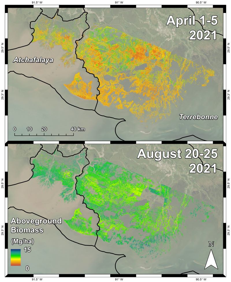
Figure 1. Herbaceous aboveground biomass (megagrams/hectare) product for the Atchafalaya and Terrebonne Basins, coastal Louisiana, derived from AVIRIS-NG data collected during the April and August 2021.
Citation
Jensen, D.J., E. Castañeda-Moya, E. Solohin, A. Rovai, D.R. Thompson, and M. Simard. 2023. Delta-X: AVIRIS-NG L3 Derived Aboveground Biomass, MRD, Louisiana, USA, 2021, V2. ORNL DAAC, Oak Ridge, Tennessee, USA. https://doi.org/10.3334/ORNLDAAC/2138
Table of Contents
- Dataset Overview
- Data Characteristics
- Application and Derivation
- Quality Assessment
- Data Acquisition, Materials, and Methods
- Data Access
- References
- Dataset Revisions
Dataset Overview
This dataset includes estimates of herbaceous aboveground biomass (AGB) for the Atchafalaya and Terrebonne basins of the Mississippi River Delta in coastal Louisiana, USA, for the early and peak-biomass seasons of 2021. AGB, quantified as dry biomass in Mg per hectare, was estimated from BRDF-adjusted surface reflectance products from NASA's Next Generation Airborne Visible Infrared Imaging Spectrometer (AVIRIS-NG) acquired over the study area in April and August 2021. The BRDF-adjusted reflectance was derived from hemispherical-directional surface reflectance with atmospheric correction. A machine learning model to estimate AGB was generated by comparing local pixel reflectance spectra with coincident in-situ samples of herbaceous vegetation AGB. This model was then scaled to the AVIRIS-NG mosaic imagery to map herbaceous AGB across the Atchafalaya and Terrebonne Basins. The Delta-X campaign conducted both airborne (remote sensing) and field (in situ) measurements to measure hydrology, water quality (e.g., total suspended solids (TSS)), and vegetation structure. These data serve to better understand rates of soil erosion, accretion, and creation in the delta system, with the goal of building better models of how river deltas will behave under relative sea level rise. The data are provided in cloud optimized GeoTIFF (COG) format. This Version 2 dataset replaces the files provided in Version 1.
Delta-X was a joint airborne and field campaign in the Mississippi River Delta that took place during Spring and Fall 2021. The Delta-X campaign conducted airborne (remote sensing) and field (in situ) measurements to observe hydrology, water quality (e.g., total suspended solids (TSS)), and vegetation structure. This data serves for the continued development of algorithms and models. The Delta-X algorithms are used to convert remote sensing observables to geophysical parameters, and to develop numerical, hydrodynamic and ecological models. These data and related models serve to better understand rates of soil erosion, accretion, and creation in the delta system, with the goal of building better models of how river deltas will behave under relative sea level rise.
Project: Delta-X
The Delta-X mission is a 5-year NASA's Earth Venture Suborbital-3 mission to study the Mississippi River Delta in the United States, which is growing and sinking in different areas. River deltas and their wetlands are drowning as a result of sea level rise and reduced sediment inputs. The Delta-X mission will determine which parts will survive and continue to grow, and which parts will be lost. Delta-X begins with airborne and in situ data acquisition and carries through data analysis, model integration, and validation to predict the extent and spatial patterns of future deltaic land loss or gain.
Related Publication
Jensen, D., Thompson, D.R., Simard, M., Solohin, E., & Castañeda-Moya, E. (in review). Imaging spectroscopy-based aboveground biomass and carbon estimation in Louisiana’s coastal wetlands: Towards consistent spectroscopy for retrievals across atmospheric states. Submitted to Remote Sensing of Environment.
Related Datasets
Jensen, D.J., E. Castañeda-Moya, E. Solohin, A. Rovai, D.R. Thompson, and M. Simard. 2022. Delta-X: Herbaceous Aboveground Biomass from AVIRIS-NG, MRD, Louisiana, USA, 2021. ORNL DAAC, Oak Ridge, Tennessee, USA. https://doi.org/10.3334/ORNLDAAC/2107
- Version 1 release of this data product.
Thompson, D.R., D.J. Jensen, J. Chapman, E. Greenberg, and M. Simard. 2021. Delta-X AVIRIS-NG L2 Surface Reflectance Products across the MRD, LA, USA, 2021. ORNL DAAC, Oak Ridge, Tennessee, USA. https://doi.org/10.3334/ORNLDAAC/1988
Thompson, D.R., D.J. Jensen, J.W. Chapman, M. Simard, and E. Greenberg. 2022. Delta-X: AVIRIS-NG BRDF-Adjusted Surface Reflectance, MRD, LA, 2021. ORNL DAAC, Oak Ridge, Tennessee, USA. https://doi.org/10.3334/ORNLDAAC/2025
Castañeda-Moya, E., and E. Solohin. 2022. Delta-X: Aboveground Biomass and Necromass across Wetlands, MRD, Louisiana, 2021. ORNL DAAC, Oak Ridge, Tennessee, USA. https://doi.org/10.3334/ORNLDAAC/2000
- This dataset provided in-situ measurements of AGB to build the empirical model.
Acknowledgments
This work was supported by NASA Earth Venture Suborbital-3 (EVS-3) program (grant NNH17ZDA001N-EVS3).
Data Characteristics
Spatial Coverage: Atchafalaya and Terrebonne Basins, southern coast of Louisiana, USA
Spatial Resolution: 4.7 m (April), 4.8 m (August)
Temporal Coverage: 2021-04-01 to 2021-08-25
Temporal Resolution: One time estimates for April and August 2021
Site Boundaries: Latitude and longitude are given in decimal degrees.
|
Site |
Westernmost Longitude |
Easternmost Longitude |
Northernmost Latitude |
Southernmost Latitude |
|---|---|---|---|---|
|
Atchafalaya and Terrebonne Basins |
-91.5907 |
-90.3991 |
29.8501 |
29.0573 |
Data File Information
This dataset holds four files in cloud optimized GeoTIFF (COG) format.
The file naming convention is ang2021<MMDD-DD>_agb_v2_<basin>_herbaceous.tif (e.g., ang20210823-25_agb_v2_Terre_herbaceous.tif), where
- <MMDD-DD> is the month (MM) and days (DD) of AVIRIS-NG image acquisition during 2021. Multiple days (DD-DD) are listed if images were acquired on >1 day.
- <basin> denotes the study area: Atchafalaya ("Atcha") or Terrebonne ("Terre").
Data characteristics
- Pixel resolution: 4.7 m (April), 4.8 m (August)
- Bands: 1, aboveground biomass of herbaceous vegetation in Mg ha-1
Application and Derivation
Aboveground biomass (AGB) is a key indicator of vegetation productivity and carbon content. The data estimated here can be used to inform maps of ecogeomorphic zones and models of accretionary processes such as sediment trapping and organic matter deposition. AGB estimates can also be used to assess wetland carbon stocks, or “blue carbon.”
Quality Assessment
The herbaceous AGB sample data (g m-2) were paired with coincident AVIRIS-NG pixel reflectance spectra and fed into a Random Forest regression model to estimate AGB.
Uncertainty in the model was characterized by compiling model performance statistics and applying a leave-one-out cross validation. The herbaceous wetland AGB model attained a model R2 of 0.89 and a mean absolute error (MAE) of 109.304 g m-2. For reference, the mean sample AGB value is 613.64 g m-2. A leave-one-out cross-validation of the model was then performed across the 84 paired AGB and reflectance samples, attaining a validation R2 score of 0.43 and MAE of 257.30 g/m2.
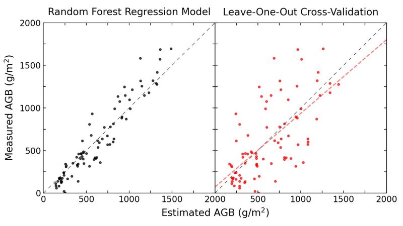
Figure 2. Error distributions of aboveground biomass (AGB) estimates for the overall Random Forest model (left) and for the leave-one-out cross-validation (right), with the associated line of best fit.
Data Acquisition, Materials, and Methods
During Spring and Fall 2021, NASA’s Airborne Visible Infrared Imaging Spectrometer-Next Generation (AVIRIS-NG) acquired data over regions of interest in the Atchafalaya and Terrebonne basins of coastal Louisiana. Delta-X was a joint airborne and field campaign in the Mississippi River Delta. This campaign conducted both airborne (remote sensing) and field (in situ) measurements to measure hydrology, water quality (e.g., total suspended solids (TSS)), and vegetation structure. These data serve to better understand rates of soil erosion, accretion, and creation in the delta system, with the goal of building better models of how river deltas will behave under relative sea level rise.
AVIRIS-NG is a pushbroom spectral mapping system with a high signal-to-noise ratio (SNR) designed for high performance spectroscopy. AVIRIS-NG was developed as a successor to the Classic Airborne Visible Infrared Imaging Spectrometer (AVIRIS-C) (Green et al., 1998). The instrument covers the entire solar reflected spectrum from 380-2510 nm with a single Focal Plane Array (FPA), at a spectral sampling of approximately 5 nm. The AVIRIS- NG sensor has a 1 milliradian instantaneous field of view, providing altitude-dependent ground sampling distance ranging from sub-meter to 20 m scales. Its detector has a 640×480-pixel array, from which standard products are generated using the sensor’s 600 cross-track spatial samples and 425 spectral samples. Each acquisition is a “flight line” forming a continuous strip of pushbroom data that typically takes 1-10 minutes to acquire. Multiple aircraft overflights cover the region of interest in these strips, accumulating a combined map of the target area. For this campaign, AVIRIS-NG was implemented on a Dynamic Aviation King Air B200. The instrument has four components: 1) a sensor with its mount and camera glass mounted at a nadir port; 2) an onboard calibrator (OBC), mounted in the cabin next to the sensor; 3) a forward operator electronics rack, and 4) an aft thermal-control electronics rack.
Each AVIRIS-NG flightline was atmospherically corrected to produce Hemispherical-Directional surface reflectance datasets (Thompson et al., 2018, 2019), followed by corrections BRDF-effects and sun-glint over land and water pixels, respectively (Queally et al., 2021; Greenberg et al., 2022).
The corrected pixel reflectance spectra coincident with herbaceous AGB field measurements of the aboveground biomass (AGB) of herbaceous vegetation (Castañeda-Moya and Solohin, 2022) from both Spring and Fall 2021 collections were used to generate a machine learning model to estimate AGB of herbaceous vegetation. This Random Forest regression model utilized the visible-shortwave infrared reflectance values as the independent variables to estimate AGB. Additional corrections were applied to the input spectra and mosaic imagery collected in August across the 880-1000 and 1080-1200 nm bands. These corrections interpolated the reflectances where there was excess noise from water vapor absorption using a conditional Gaussian interpolation algorithm trained on the EMIT vegetation spectral library (Jensen et al. in review).
To apply the AGB model to the AVIRIS-NG data, the Spring and Fall mosaics for both the Atchafalaya and Terrebonne Basins were classified to separate herbaceous vegetation from forest, floating aquatic vegetation, soil, water, clouds, and cloud shadows. The regression model was then applied to the image mosaics for the classified herbaceous wetland pixels, and the final products were converted to megagrams per hectare (Mg ha-1).
Data Access
These data are available through the Oak Ridge National Laboratory (ORNL) Distributed Active Archive Center (DAAC).
Delta-X: AVIRIS-NG L3 Derived Aboveground Biomass, MRD, Louisiana, USA, 2021, V2
Contact for Data Center Access Information:
- E-mail: uso@daac.ornl.gov
- Telephone: +1 (865) 241-3952
References
Castañeda-Moya, E., and E. Solohin. 2022. Delta-X: Aboveground Biomass and Necromass across Wetlands, MRD, Louisiana, 2021. ORNL DAAC, Oak Ridge, Tennessee, USA. https://doi.org/10.3334/ORNLDAAC/2000
Jensen, D., Thompson, D.R., Simard, M., Solohin, E., & Castañeda-Moya, E. (in review). Imaging spectroscopy-based aboveground biomass and carbon estimation in Louisiana’s coastal wetlands: Towards consistent spectroscopy for retrievals across atmospheric states. Submitted to Remote Sensing of Environment.
Green, R.O., M.L. Eastwood, C.M. Sarture, T.G. Chrien, M. Aronsson, B.J. Chippendale, J.A. Faust, B.E. Pavri, C.J. Chovit, M. Solis, M.R. Olah, and O. Williams. 1998. Imaging spectroscopy and the Airborne Visible/Infrared Imaging Spectrometer (AVIRIS). Remote Sensing of Environment 65:227–248. https://doi.org/10.1016/S0034-4257(98)00064-9
Greenberg, E., D. R. Thompson, D. Jensen, P. A. Townsend, N. Queally, A. Chlus, C. G. Fichot, J. P. Harringmeyer, and M. Simard. 2022. An improved scheme for correcting remote spectral surface reflectance simultaneously for terrestrial BRDF and water-surface sunglint in coastal environments. Journal of Geophysical Research: Biogeosciences 127:e2021JG006712. https://doi.org/10.1029/2021JG006712
Queally, N., Z. Ye, T. Zheng, A. Chlus, F. Schneider, R. Pavlick, and P.A. Townsend. 2021. FlexBRDF: A flexible BRDF correction for grouped processing of airborne imaging spectroscopy flightlines. Earth and Space Science Open Archive. Preprint. https://doi.org/10.1002/essoar.10506891.1
Thompson, D.R., D.J. Jensen, J. Chapman, E. Greenberg, and M. Simard. 2021. Delta-X AVIRIS-NG L2 Surface Reflectance Products across the MRD, LA, USA, 2021. ORNL DAAC, Oak Ridge, Tennessee, USA. https://doi.org/10.3334/ORNLDAAC/1988
Thompson, D.R., D.J. Jensen, J.W. Chapman, M. Simard, and E. Greenberg. 2022. Delta-X: AVIRIS-NG BRDF-Adjusted Surface Reflectance, MRD, LA, 2021. ORNL DAAC, Oak Ridge, Tennessee, USA. https://doi.org/10.3334/ORNLDAAC/2025
Thompson, D.R., K. Cawse-Nicholson, Z. Erickson, C.G. Fichot, C. Frankenberg, B.-C. Gao, M.M. Gierach, R.O. Green, D. Jensen, V. Natraj, and A. Thompson. 2019. A unified approach to estimate land and water reflectances with uncertainties for coastal imaging spectroscopy. Remote Sensing of Environment 231:111198. https://doi.org/10.1016/j.rse.2019.05.017
Thompson, D.R., V. Natraj, R.O. Green, M.C. Helmlinger, B.-C. Gao, and M.L. Eastwood. 2018. Optimal estimation for imaging spectrometer atmospheric correction. Remote Sensing of Environment 216:355–373. https://doi.org/10.1016/j.rse.2018.07.003
Dataset Revisions
| Version | Release Date | Revision Notes |
|---|---|---|
| 2.0 | 2023-03-15 | All four data files replaced with updated versions |
| 1.0 | 2022-11-11 | Original Version 1 release (https://doi.org/10.3334/ORNLDAAC/2107). Now superseded by Version 2. |