Documentation Revision Date: 2022-08-29
Dataset Version: 2
Summary
Delta-X conducted a joint airborne and field campaign in the Mississippi River Delta (MRD) during Spring and Fall 2021. The Delta-X campaign conducted airborne (remote sensing) and field (in situ) measurements to observe hydrology, water quality (e.g., total suspended solids (TSS)) and vegetation structure.
This dataset consists of one file in comma-separated values (CSV) format.
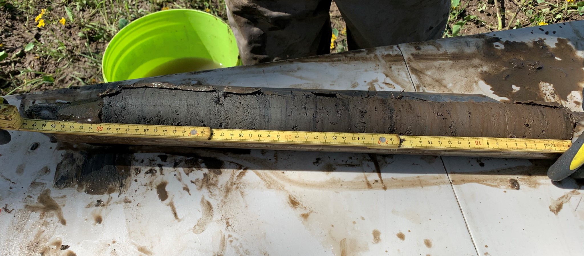
Figure 1. Typical soil core from herbaceous wetland collected during March 2021 in coastal Louisiana. This image shows the top 50 cm of soil collected using a Russian corer.
Citation
Castañeda-Moya, E., and E. Solohin. 2022. Delta-X: Soil Properties for Herbaceous Wetlands, MRD, Louisiana, 2021. ORNL DAAC, Oak Ridge, Tennessee, USA. https://doi.org/10.3334/ORNLDAAC/2078
Table of Contents
- Dataset Overview
- Data Characteristics
- Application and Derivation
- Quality Assessment
- Data Acquisition, Materials, and Methods
- Data Access
- References
- Dataset Revisions
Dataset Overview
This dataset contains properties of soil core samples for herbaceous wetlands collected in the Atchafalaya and Terrebonne basins in southeastern coastal Louisiana during 2021-03-19 to 2021-04-02 and on 2021-08-19. Field measurements were conducted at six sites in the Atchafalaya (N = 3) and Terrebonne (N = 3). Five of the sites were adjacent to sites from the Coastwide Reference Monitoring System (CRMS; Steyer et al. 2003). The other site is in the Wax Lake Delta (WLD) without appropriate adjacent CRMS sites. Herbaceous wetland sites in both basins were chosen to represent a salinity gradient including freshwater, brackish and saline ecosystems. Soil properties include bulk density, organic matter content, and total densities of carbon, nitrogen, and phosphorus.
Project: Delta-X
The Delta-X mission is a 5-year NASA Earth Venture Suborbital-3 mission to study the Mississippi River Delta in the United States, which is growing and sinking in different areas. River deltas and their wetlands are drowning as a result of sea level rise and reduced sediment inputs. The Delta-X mission will determine which parts will survive and continue to grow, and which parts will be lost. Delta-X begins with airborne and in situ data acquisition and carries through data analysis, model integration, and validation to predict the extent and spatial patterns of future deltaic land loss or gain.
Acknowledgments
This work was supported by NASA's Earth Venture Suborbital-3 (EVS-3) program (grant NNH17ZDA001N-EVS3).
Data Characteristics
Spatial Coverage: Atchafalaya and Terrebonne Basins, southern coast of Louisiana, USA
Spatial Resolution: Point samples, spaced 30 m apart along transects.
Temporal Coverage: 2021-03-19 to 2021-04-02 and on 2021-08-19
Temporal Resolution: One-time samples
Site Boundaries: Latitude and longitude are given in decimal degrees.
| Site | Westernmost Longitude | Easternmost Longitude | Northernmost Latitude | Southernmost Latitude |
|---|---|---|---|---|
| Atchafalaya and Terrebonne Basins | -91.4451 | -90.8219 | 29.5400 | 29.1714 |
Data File Information
This dataset consists of a single file in CSV format named DeltaX_Soil_Properties.csv.
The no data value is -9999.
Table 1. Variables in DeltaX_Soil_Properties.csv.
| Variable | Units | Description |
|---|---|---|
| basin | - | “Atchafalaya” or “Terrebonne” |
| campaign | - | "Spring_2021" or "Fall_2021" |
| date | YYYY-MM-DD | Date of sampling |
| latitude | degree_north | Latitude of sampling site |
| longitude | degree_east | Longitude of sampling site |
| site_id | - | Site name |
| hydrogeomorphic_zone | - | "Supratidal" or "Intertidal" |
| sampling_station | - | Sampling station ID |
| soil_core_id | - | Soil core ID (1, 2) |
| depth_interval | text | Depth interval of the soil sample for each core in cm (e.g., "10-20 cm") |
| soil_bulk_density | g cm-3 | Dry mass of soil divided by its wet volume |
| soil_organic_matter_content | percent | Percent of organic matter in known dry mass of soil |
| soil_total_carbon_density | mg cm-3 | Total carbon density in known wet volume of soil |
| soil_total_nitrogen_density | mg cm-3 | Total nitrogen density in known wet volume of soil |
| soil_total_phosphorus_density | mg cm-3 | Total phosphorus density in known wet volume of soil |
Application and Derivation
Soil properties data will be used to calibrate and validate the ecogeomorphic (NUMAR) and hydrodynamic models. Data will be used to characterize in situ soil properties across all Delta X sites and to explain changes in vegetation dynamics as a function of soil characteristics. This research will contribute to a better understanding of changes in soil carbon and nutrient (N, P) concentrations, bulk density, and organic matter content due to seasonality, vegetation growth, and river discharge.
Quality Assessment
Data quality for each soil property (e.g., bulk density, N, etc.) was initially assessed using standard error (SE) and coefficient of variation statistics. Carbon and nutrient analyses were determined on duplicate analytical replicates of each sample, and the run precision was determined based on relative percent difference between replicates at an acceptance limit of <5%. Accuracy and quality control were determined by the analysis of certified standard reference material during each run. Acceptable limits for accuracy were ±5%. Data outside these limits was not used, and samples were re-run to obtain new accurate values.
Data Acquisition, Materials, and Methods
Soil cores were collected at six herbaceous wetland sites (Fig. 2) during the Delta-X 2021 field efforts (2021-03-19 to 2021-04-02). Intertidal stations at the Mike Island site in the Wax Lake Delta (WLD) were sampled on 2021-08-19. Soil studies determine changes in soil carbon and nutrient (N, P) concentrations, bulk density, and organic matter content due to seasonality, vegetation growth, and river discharge regime (high vs. low).
Five out of the six selected sites for field measurements are part of the Coastal Reference Monitoring System (CRMS; Steyer et al., 2003), and they are labeled with ‘CRMS’ in the site_id variable. The WLD site did not have an adjacent CRMS site.

Figure 2. Vegetation sampling sites in Atchafalaya and Terrebonne Basins for the Delta-X 2021 field efforts. The Wax Lake Delta (WLD) location has the site_id "Mike Island" in the datafile. Data are not provided for the CRMS2568 site.
At each site, a transect was established perpendicular to the wetland edge to capture a range of hydrogeomorphic zones (HGM, supratidal and intertidal). In each HGM, two sampling stations were established 30 m apart (parallel to the wetland edge). At each sampling station, within each site, one 50-cm soil core was collected using a Russian peat corer (5 cm diameter). Soil cores were sectioned into 10-cm intervals and stored on ice in plastic bags for further analyses in the laboratory.
Soil cores were further processed in the lab to determine soil properties including carbon and nutrient (N, P) concentrations and ratios, bulk density, and organic matter content. Core samples were ground with a Wiley Mill to pass through a 250-μm-mesh screen and stored separately in glass scintillation vials. Organic matter content (% ash-free dry weight) was determined by loss-on-ignition (LOI) at 550ºC for 4 hours (Davies, 1974). Total carbon (C) and nitrogen (N) concentrations of soil samples were determined for each sample with a NA1500 elemental analyzer (Fisons, Instruments, Inc., Danvers, MA). Ashed samples were also analyzed for total inorganic C (TIC) and the percentage of organic carbon was calculated as the difference between TIC and total carbon (TC) (Dean, 1974; Fourqurean et al., 2012). Total P was extracted using an acid-digested (HCl) extraction and concentrations determined by colorimetric analysis (Methods 365.4 and 365.2; EPA, 1983). Carbon and nutrient content are expressed on a volume basis (mg cm-3) using bulk density values.
Data Access
These data are available through the Oak Ridge National Laboratory (ORNL) Distributed Active Archive Center (DAAC).
Delta-X: Soil Properties for Herbaceous Wetlands, MRD, Louisiana, 2021
Contact for Data Center Access Information:
- E-mail: uso@daac.ornl.gov
- Telephone: +1 (865) 241-3952
References
Davies, B.E. 1974. Loss-on-ignition as an estimate of soil organic matter. Soil Science Society of America Journal 38:150-151. https://doi.org/10.2136/sssaj1974.03615995003800010046x
Dean, W.E., Jr. 1974. Determination of carbonate and organic matter in calcareous sediments and sedimentary rocks by loss on ignition: comparison with other methods. SEPM Journal of Sedimentary Research Vol. 44. https://doi.org/10.1306/74D729D2-2B21-11D7-8648000102C1865D
EPA. 1983. Method 365.4: Total phosphorus (Colorimetric, automated, block digester AA II): US EPA Environmental Protection Agency Washington, DC. https://www.epa.gov/sites/default/files/2015-08/documents/method_365-4_1974.pdf
Fourqurean, J.W., G.A. Kendrick, L.S. Collins, R.M. Chambers, and M.A. Vanderklift. 2012. Carbon, nitrogen and phosphorus storage in subtropical seagrass meadows: examples from Florida Bay and Shark Bay. Marine and Freshwater Research 63:967-983. https://doi.org/10.1071/MF12101
Steyer, G.D., C.E. Sasser, J.M. Visser, E.M. Swenson, J.A. Nyman, and R.C. Raynie. 2003. A proposed coast-wide reference monitoring system for evaluating wetland restoration trajectories in Louisiana. Environmental Monitoring and Assessment 81:107-117. https://doi.org/10.1023/A:1021368722681
Dataset Revisions
| Version | Release Date | Revision Notes |
| 2.0 | 2022-08-29 | Data from August 2021 samples were added. Data from Spring 2021 were updated. Title was revised. |
| 1.0 | 2022-05-02 | Original release with Spring 2021 data. |