Documentation Revision Date: 2022-09-23
Dataset Version: 2
Summary
This dataset includes one file in comma-separated values (*.csv) format.
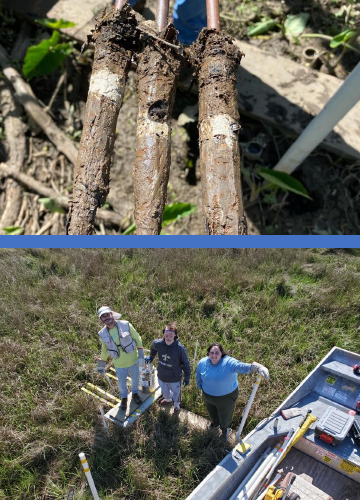
Figure 1. Top image: Cryocores showing sediment deposited on top of feldspar marker horizon; Bottom image: Feldspar station set up.
Citation
Twilley, R., A. Fontenot-Cassaway, and A. Rovai. 2022. Delta-X: Feldspar Sediment Accretion Measurements, MRD, LA, USA, 2019-2021, Version 2. ORNL DAAC, Oak Ridge, Tennessee, USA. https://doi.org/10.3334/ORNLDAAC/2079
Table of Contents
- Dataset Overview
- Data Characteristics
- Application and Derivation
- Quality Assessment
- Data Acquisition, Materials, and Methods
- Data Access
- References
- Dataset Revisions
Dataset Overview
This dataset provides elevation, hydrogeomorphic zone classification, soil carbon content, bulk density, organic matter content, and sediment accretion measurements collected at feldspar stations established near Louisiana's Coastwide Reference Monitoring Systems (CRMS) sites and on Mike Island in Wax Lake Delta (WLD). Feldspar Stations were established to capture recent sediment deposition rates across hydrogeomorphic zones defined as discrete surface elevation ranges relative to NAVD88 (e.g., subtidal < -0.04 m, intertidal -0.04 m to 0.30 m, and supratidal > 0.30 m; after Bevington & Twilley 2018). Hydrogeomorphic zones classification was based on marsh surface elevations extracted from the U.S. Geological Survey (USGS) Atchafalaya 2 project LiDAR Survey 2012 digital elevation model (https://www.sciencebase.gov/catalog/item/543e6b86e4b0fd76af69cf4c). Between two and three feldspar stations were deployed approximately 25 and 50 m from the main channel to represent existing hydrogeomorphic zones in tidal freshwater emergent marshes, and forested swamps. Cryocore technique was used to determine recent sediment deposition. Soil samples were collected to determine organic and inorganic fractions and organic carbon content.
Project: Delta-X
The Delta-X mission is a 5-year NASA Earth Venture Suborbital-3 mission to study the Mississippi River Delta in the United States, which is growing and sinking in different areas. River deltas and their wetlands are drowning as a result of sea level rise and reduced sediment inputs. The Delta-X mission will determine which parts will survive and continue to grow, and which parts will be lost. Delta-X begins with airborne and in-situ data acquisition and carries through data analysis, model integration, and validation to predict the extent and spatial patterns of future deltaic land loss or gain.
Related Datasets
Twilley, R., A. Fontenot-Cassaway, and A. Rovai. 2021. Delta-X: Feldspar Sediment Accretion Measurements for Coastal Wetlands, MRD, LA, USA. ORNL DAAC, Oak Ridge, Tennessee, USA. https://doi.org/10.3334/ORNLDAAC/1998
- Version 1 release of this dataset.
Acknowledgements
This research was funded by the NASA Earth Venture Suborbital-3 Program, grant number NNH17ZDA001N-EVS3.
Data Characteristics
Spatial Coverage: Louisiana's Coastwide Reference Monitoring Systems (CRMS) sites and on Mike Island in Wax Lake Delta (WLD), southern coast of Louisiana, USA
Spatial Resolution: Point
Temporal Coverage: Fall 2020 sampling: 2020-10-04 to 2020-11-10; Fall 2021 sampling: 2021-08-19 to 2021-10-06; Spring 2021 sampling: 2021-03-21-2021-03-31 and 2021-08-19
Temporal Resolution: One-time field measurements
Site Boundaries: Latitude and longitude are given in decimal degrees.
| Site | Westernmost Longitude | Easternmost Longitude | Northernmost Latitude | Southernmost Latitude |
|---|---|---|---|---|
| Louisiana's CRMS sites and on Mike Island in WLD, southern coast of Louisiana | -91.4449 | -90.8224 | 29.5643 | 29.1714 |
There is one data file in comma-separated values (.csv) format with this dataset: DeltaX_Soil_Properties_Fall2020_Spring2021_Fall2021.csv
Numeric data not included in the file are represented as -9999; missing text data are indicated by NA.
Table 1. Variables in the data file.
| Variable | Units | Description |
|---|---|---|
| basin | Basin: "Atchafalaya" or "Terrebonne" | |
| campaign | Sampling season: Fall_2020, Spring_2021, or Fall_2021 | |
| site_id | Site ID’s: CRMS_0294, CRMS_0322, CRMS_0399, CRMS_0396, CRMS_0421, CRMS_2568, WLD_T1, WLD_T3. | |
| hydrogeomorphic_zone | Hydrogeomorphic zone classification: subtidal, intertidal or supratidal | |
| elevation_navd88 | m | Elevation in meters relative to NAVD88 |
| latitude | degrees north | Latitude in decimal degrees |
| longitude | degrees east | Longitude in decimal degrees |
| station | Feldspar Stations ID’s: herbaceous marshes (V25 and V50), forested swamp (T25), Supratidal (SUP), Intertidal (INT) and Subtidal (SUB) | |
| plot | 50 x 50 cm feldspar marker horizons plots: X, Y and Z | |
| replicate | Replicate ID’s for measurements taken from each cryocore: A,B or C | |
| sample_id | Unique soil samples ID’s | |
| time_marker_deployed | YYYY-MM-DD hh:mm:ss | Date and time feldspar marker horizon plots were deployed |
| time_marker_sampled | YYYY-MM-DD hh:mm:ss | Date and time feldspar marker horizon plots were sampled |
| notes_time_marker_sampled | Notes regarding sampling. Corresponding time_marker_sampled values are -9999 | |
| sediment_accretion | mm | Height of sediment accreted on top of feldspar marker horizon plots since deployment date |
| days_between_sampling_and_deployment | days | Number of days between feldspar marker horizon plots deployment and sampling event |
| normalized_accretion | mm yr-1 | Yearly normalized sediment accretion (mm yr-1) obtained by multiplying sediment accretion (mm) by 365 days per year and then dividing the result by the number of days between feldspar marker horizon plots deployment and sampling event |
| soil_bulk_density | g cm-3 | Soil bulk density calculated from the sample's dry weight divided by its wet volume. Wet volume determined from the cross-sectional area of the core (cm2) multiplied by the length the soil column interval (cm) |
| soil_organic_matter_content | percentage | Organic matter content determined by loss on ignition (% of dry mass) |
| soil_organic_carbon | percentage | Percent organic carbon determined on acid-fumigated soil samples using elemental analyzer (% of dry mass) |
| soil_organic_carbon_density | g cm-3 | Soil organic density obtained by multiplying sample's bulk density (g cm-3) by its organic carbon fraction (g g-1). |
Application and Derivation
Sediment accretion data will be used to calibrate and validate the ecogeomorphic (NUMAR, modified from NUMAN model by Chen and Twilley 1998) and hydrodynamic models. Data will be used to characterize in situ sediment deposition patterns across all Delta X sites and to explain changes in sediment deposition across distinct hydrogeomorphic zones. This research will contribute to a better understanding of changes in sediment accretion, organic matter accumulation rates and soil carbon sequestration rates due to vegetation composition, salinity gradients and riverine sediment and nutrient loadings.
Quality Assessment
Data quality for each loss-on-ignition and carbon content of soil samples was obtained using duplicate analytical replicates of each sample. The run precision was determined based on relative percent difference between replicates at an acceptance limit of <5%. For carbon content, accuracy and quality control were determined by the analysis of certified standard reference material during each run. Acceptable limits for accuracy were ± 5%. Data outside these limits was not used and samples were re-run to obtain new accurate values.
Data Acquisition, Materials, and Methods
Feldspar Stations were established nearby Louisiana's Coastwide Reference Monitoring Systems (CRMS) sites and on Mike Island in Wax Lake Delta (WLD) to capture recent sediment deposition rates across hydrogeomorphic zones. These zones were defined as discrete surface elevation ranges relative to NAVD88 (e.g., subtidal < -0.04 m, intertidal -0.04 m to 0.30 m, and supratidal > 0.30 m; after Bevington & Twilley 2018). Hydrogeomorphic zones classification was based on marsh surface elevation measurements acquired in November and December 2020 using a RTK GPS (Trible R12, using Geoid 18).
For CRMS_0294, CRMS_0322, CRMS_0399, CRMS_0396, and CRMS_0421, two feldspar stations were deployed in vegetated areas approximately 25 and 50 m from a main channel (V25 & V50). For CRMS_2568, two feldspar stations were deployed: one station in herbaceous vegetation (V25) and one station in forested vegetation (T25), both approximately 25 m from a main channel. In Wax Lake Delta (WLD), six feldspar stations were deployed: three stations along a transect near the island’s apex (T1) at supratidal, Intertidal and subtidal (SUP, INT, and SUB) hydrogeomorphic zones, and three stations along a transect near delta front (T3) at intertidal and subtidal (SUP, INT, and SUB) hydrogeomorphic zones.
At each feldspar station, three 50 x 50 cm feldspar marker horizons plots (X, Y, and Z) were deployed on the soil surface. Each cryocore sample measured for accretion was given a replicate ID (A, B or C). Each cryocore showing a clear, white feldspar marker horizon was measured from the current soil surface to the top of the feldspar marker horizon. Each accretion measurement reported is the average of three individual measurements made with calipers.
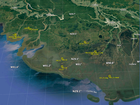
Figure 2. Map showing the distribution of feldspar sampling stations across Atchafalaya and Terrebonne coastal basins.
To assess organic and inorganic fractions of newly deposited material, soil cores corresponding to sediment accretion measurements (e.g., height of sediment above feldspar marker) were collected next to feldspar markers plots using cryocore technique. This strategy reduced disturbance to feldspar markers horizon plots, extending the makers’ longevity. Soil samples were dried at 60° C until constant weight. Bulk density was calculated as the sample's dry weight divided its wet volume (g cm-3). Wet volume is determined from the cross-sectional area (cm2) of the soil core multiplied by the depth of each soil section (cm, based on the height of sediment above feldspar marker). Samples were homogenized and ground using a Wiley Mill. Organic matter content was determined by loss on ignition after combusting samples of a known mass at 550°C for 2 hours (Davies, 1974). Soil samples were fumigated in a desiccator for 8 hours with 12M HCl to remove inorganic carbonates (Harris et. al. 2001). Percent organic carbon on fumigated samples was measured with a ECS 4010 elemental analyzer (Costech Analytical Technologies Inc., Valencia, California). Soil organic density was calculated by multiplying the sample's bulk density (g cm-3) by the sample' s organic carbon fraction (g g-1).
Data Access
These data are available through the Oak Ridge National Laboratory (ORNL) Distributed Active Archive Center (DAAC).
Delta-X: Feldspar Sediment Accretion Measurements, MRD, LA, USA, 2019-2021, Version 2
Contact for Data Center Access Information:
- E-mail: uso@daac.ornl.gov
- Telephone: +1 (865) 241-3952
References
Bevington A.E., and R.R. Twilley. 2018. Island edge morphodynamics along a chronosequence in a prograding deltaic floodplain wetland. Journal of Coastal Research 34:806-817. https://doi.org/10.2112/JCOASTRES-D-17-00074.1
Chen, R., and R.R. Twilley. 2019. A simulation model of organic matter and nutrient accumulation in mangrove wetland soils. Biogeochemistry 44:93–118. https://doi.org/10.1007/BF00993000
Davies, B. 1974. Loss-on-ignition as an estimate of soil organic matter. Soil Science Society of America Journal 38:150-151. https://doi.org/10.2136/sssaj1974.03615995003800010046x
Harris D., W.R. Horwáth, and C. van Kessel. 2001. Acid fumigation of soils to remove carbonates prior to total organic carbon or carbon-13 isotopic analysis. Soil Science Society of America Journal 65:1853–1856. https://doi.org/10.2136/sssaj2001.1853
Dataset Revisions
|
Version |
Release Date |
Description |
|
2.0 |
2022-09-23 |
Fall 2021 data were added to the dataset; Fall 2020 and Spring 2021 data were updated. |
|
1.0 |
2022-05-02 |
Initial release with Fall 2020 and Spring 2021 data. |