Documentation Revision Date: 2022-11-17
Dataset Version: 1
Summary
This dataset includes 12 files: three shapefiles in separate Zip archives that hold the ecogeomorphic polygons, three GeoTIFFs that provide a raster version of the shapefiles, and six multiband GeoTIFFs that hold the means and standard deviations of bathymetry, NIR, and NDVI values for each polygon.
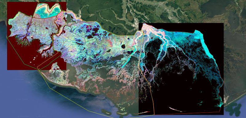
Figure 1. RGB composite image of the Atchafalaya and Terrebonne basins (R=Bathymetry, G=NIR of 1st quarter, B=NIR of 3rd quarter) highlighting the various ecological and geomorphological features of the landscape.
Citation
Simard, M., M.W. Denbina, E. Rodriguez, A.L. Christensen, K.A. Wright, and A. Rovai. 2022. Delta-X: Ecogeomorphic Cell Products across the MRD, LA, USA, 2021. ORNL DAAC, Oak Ridge, Tennessee, USA. https://doi.org/10.3334/ORNLDAAC/2108
Table of Contents
- Dataset Overview
- Data Characteristics
- Application and Derivation
- Quality Assessment
- Data Acquisition, Materials, and Methods
- Data Access
- References
Dataset Overview
This product delineates the Mississippi River Delta (MRD) landscape into distinct ecogeomorphic cells, which are small contiguous areas of land with similar ecological and geomorphological characteristics. The study area is the Atchafalaya and Terrebonne basins of the MRD in southern Louisiana, U.S., which was the focus of NASA's 2021 Delta-X campaign. Each ecogeomorphic cell is a small homogeneous area of similar vegetation and elevation (or bathymetry). A "cell" typically consists of a cluster of contiguous pixels in a raster image, although cells of single pixels are present. The elevation was derived from the USGS Digital Elevation Model, and the vegetation was characterized by its spectral signature as measured by near infrared (NIR) reflectance and normalized difference vegetation index (NDVI). NIR and NDVI were computed from Sentinel-2 images acquired January through September 2021. The data are provided in shapefile and GeoTIFF formats. The vector shapefiles contain the distinct ecogeomorphic cells as polygons with unique labels (i.e., ID number). A raster image of these ecogeomorphic cells is provided wherein the pixel values are the polygon labels from the shapefiles. The GeoTIFFs hold the mean and standard deviations of bathymetry, NIR, and NDVI spectral indices within each ecogeomorphic region (polygon). The raster data are provided with a spatial resolution of 0.000045 degrees (approximately 5 meters).
Project: Delta-X
The Delta-X mission is a 5-year NASA Earth Venture Suborbital-3 mission to study the Mississippi River Delta in the United States, which is growing and sinking in different areas. River deltas and their wetlands are drowning as a result of sea level rise and reduced sediment inputs. The Delta-X mission will determine which parts will survive and continue to grow, and which parts will be lost. Delta-X begins with airborne and in situ data acquisition and carries through data analysis, model integration, and validation to predict the extent and spatial patterns of future deltaic land loss or gain.
Related dataset
Denbina, M.W., M. Simard, T.M. Pavelsky, A.I. Christensen, K. Liu, and C. Lyon. 2020. Pre-Delta-X: Channel Bathymetry of the Atchafalaya Basin, LA, USA, 2016. ORNL DAAC, Oak Ridge, Tennessee, USA. https://doi.org/10.3334/ORNLDAAC/1807
Acknowledgements
This study was funded with the Earth Venture Suborbital (EVS-3) program, grant number NNH17ZDA001N-EVS3.
Data Characteristics
Spatial Coverage: Atchafalaya and Terrebonne Basins, southern coast of Louisiana, USA
Spatial Resolution: 0.000045 degrees (approximately 5 m)
Temporal Coverage: 2021-01-01 to 2021-09-30
Temporal Resolution: One time estimate
Site Boundaries: Latitude and longitude are given in decimal degrees.
| Site | Westernmost Longitude | Easternmost Longitude | Northernmost Latitude | Southernmost Latitude |
|---|---|---|---|---|
| Atchafalaya and Terrebonne Basins | -91.5502 | -90.1837 | 29.7447 | 29.3205 |
Data File Information
This dataset includes 12 files: three shapefiles in separate Zip archives that hold the ecogeomorphic polygons, three GeoTIFFs that provide a raster version of the shapefiles, and six multiband GeoTIFFs that hold the means and standard deviations of bathymetry, NIR, and NDIV values for each polygon.
An ecogeomorphic cell is a small homogeneous area of similar vegetation and elevation (or bathymetry). A "cell" typically consists of a cluster of contiguous pixels in a GeoTIFF, although cells of single pixels are present.
The file names include the names of the three study areas: Atchafalaya, Terrebonne East ("TerrebonneEast") and Terrebonne West ("TerrebonneWest").
Table 1. File names and descriptions.
| File name | Description |
|---|---|
| DeltaX_EcoGeoCells_2021_<study_area>.zip | Zip archive holding a shapefile (*.shp) of polygons of each ecogeomorphic cell. Ancillary files with extensions *.shx, *.dbf, *.prj, and *.cpg are included. Each polygon has a distinct numerical identifier (ID). |
| DeltaX_EcoGeoCells_2021_<study_area>.tif | Raster file in GeoTIFF format. The pixel values are the same as the polygon ID in the shapefile. Pixel values of 0 indicate the water mask used to mask out deep water and large channels. |
| DeltaX_EcoGeoCells_2021_<study_area>_mean_superpixels.tif | Raster file in GeoTIFF format with 5 bands. The bands hold the mean values for each ecogeomorphic cell. The bands are bathymetry, near infrared (NIR) reflectance of 1st quarter, NIR of 3rd quarter, normalized difference vegetation index (NDVI) of 1st quarter, and NDVI of 3rd quarter. |
| DeltaX_EcoGeoCells_2021_<study_area>_std_superpixels.tif | Raster file in GeoTIFF format with 5 bands. The bands hold the standard deviation of values for each ecogeomorphic cell. The bands are bathymetry, NIR of 1st quarter, NIR of 3rd quarter, NDVI of 1st quarter, and NDVI of 3rd quarter. |
Characteristics of GeoTIFFs:
- Projection: Geographic coordinates (longitude, latitude), WGS 84 datum, EPSG:4326
- Pixel size: 0.000045 degrees (approximately 5 meters)
- There are no pixels with missing data; however, deep water and large channels were masked out during analysis.
The masked pixels have value 0 in DeltaX_EcoGeoCells_2021_<study_area>.tif.
Table 2. Variables provided in the dataset.
| Variable | Units | Description |
| Ecogeomorphic cell polygons | - | Delineation of homogeneous regions with similar vegetation and elevation. |
| Bathymetry or elevation in wetlands | m | Elevation within wetlands with respect to NAVD 88 sampled at 10 meters. Large channels were masked out. |
| Near Infrared (NIR) reflectance | 1 | Reflectance from Sentinel-2 band 8, central wavelength 0.842 µm. |
| Normalized Vegetation Index (NDVI) | 1 | NDVI = (NIR-RED)/(NIR+RED). Values range from -1 to +1. |
Application and Derivation
This product is used to delineate homogeneous patches of the landscape, which is to help aggregate attributes from other products into objects rather than pixels. For example, single value of AGB or elevation derived in other product can be attributed to one cell rather than to each pixel.
Quality Assessment
Open water and main channels were masked during analysis. The water mask was based on National Agriculture Imagery Program (NAIP) data and some channels may have evolved. The USGS bathymetry has an uncertainty of about 10 to 20 cm in elevation in shallow marshes. However, the uncertainty in channels is very large and should not be trusted. Also, the elevation in heavily vegetated regions may have larger uncertainty. The remotely-sensed vegetation spectral characteristics partially capture variations in bathymetry that control vegetation type. The concept of ecogeomorphic cells assumes an homogeneous patch of vegetation has similar elevation.
Data Acquisition, Materials, and Methods
This product delineates the Mississippi River Delta (MRD) landscape into distinct ecogeomorphic regions, which are small contiguous areas of land with similar ecological and geomorphological characteristics. The study area is the Atchafalaya and Terrebonne basins of the MRD in southern Louisiana, U.S., which was the focus of NASA’s 2021 Delta-X campaign.
An ecogeomorphic cell is a small area of similar vegetation and elevation (or bathymetry). A "cell" typically consists of a cluster of contiguous pixels in a raster image, although cells of single pixels are present. An area of similar elevation is often termed a "hydrogeomorphic zone". This analysis extends that concept by adding similarity in vegetation as defined by spectral signatures. The ecogeomorphic cells are derived by identifying homogeneous areas from from five input data layers:
- Bathymetry
- Composite near-infrared (NIR) image generated from all cloud-free Sentinel-2 images of the first quarter (January-March) of 2021
- Composite near-infrared (NIR) image generated from all cloud-free Sentinel-2 images of the third quarter (July-September) of 2021
- Composite Normalized Vegetation Index (NDVI) generated from all cloud-free Sentinel-2 images of the first quarter (January-March) of 2021
- Composite Normalized Vegetation Index (NDVI) generated from all cloud-free Sentinel-2 images of the third quarter (July-September) of 2021
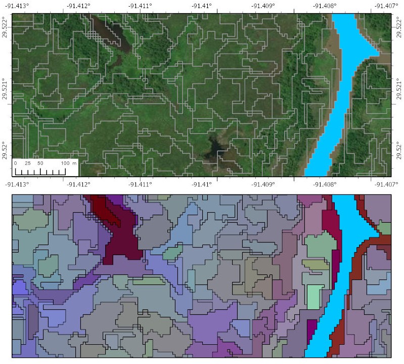
Figure 2. A true color satellite image from a portion of the Atchafalaya basin (top) and a RGB image of delineated ecogeomorphic cells in same region (bottom) illustrating spatial pattern of ecological and geomorphological features (R=Bathymetry, G=NIR of 1st quarter, B=NIR of 3rd quarter). The bright blue area on right side of each panel is a deep water channel excluded from analysis by the water mask.
The bathymetry/elevation map is also summarized in Debina et al. (2020). The USGS National Elevation Dataset (NED; Gesch et al., 2002) which was used as a DEM over land areas only; Shaw et. al (2016) bathymetry used in areas of the Wax Lake Delta without sonar data coverage from Delta-X surveys; bathymetry sourced from publicly available data was used for places where bathymetry was not available from other sources; and synthetic bathymetry calculated as a multiple of the river channel width. The fraction of total weights for each component of the merged product was determined by a mixture of parameters such as area, distance from land or water, distance from nearest bathymetry sample in the case of interpolated data, etc.
The use of first and third quarter imagery improved distinction between evergreen and seasonal deciduous plant types. The Sentinel-2 composite images were generated using the freely available Mosaic Hub tool with an original 10-m spatial resolution then oversampled to 5 m through bilinear interpolation. This resolution was an efficient compromise to preserve delineation of ecogeomorphic cells and better match features with the NAIP and the elevation datasets.
All data are provided with a coordinate reference system of EPSG:4326 and horizontal datum of WGS 84. The bathymetry is in the NAVD 88 vertical datum. Data not covered or considered open water are represented by 0 in the raster files DeltaX_EcoGeoCells_2021_<study_area>.tif.
Data Access
These data are available through the Oak Ridge National Laboratory (ORNL) Distributed Active Archive Center (DAAC).
Delta-X: Ecogeomorphic Cell Products across the MRD, LA, USA, 2021
Contact for Data Center Access Information:
- E-mail: uso@daac.ornl.gov
- Telephone: +1 (865) 241-3952
References
Denbina, M.W., M. Simard, T.M. Pavelsky, A.I. Christensen, K. Liu, and C. Lyon. 2020. Pre-Delta-X: Channel Bathymetry of the Atchafalaya Basin, LA, USA, 2016. ORNL DAAC, Oak Ridge, Tennessee, USA. https://doi.org/10.3334/ORNLDAAC/1807
Gesch, D., M.J. Oimoen, S.K. Greenlee, C.A. Nelson, M. Steuck, and D.J. Tyler. 2002. The National Elevation Dataset. Photogrammetric Engineering and Remote Sensing 68:5-11.
Shaw, J.B., D. Mohrig, and R.W. Wagner. 2016. Flow patterns and morphology of a prograding river delta. Journal of Geophysical Research: Earth Surface 121:372–-391. https://doi.org/10.1002/2015JF003570