Documentation Revision Date: 2024-02-01
Dataset Version: 1
Summary
There are 11 data files in netCDF (.nc4) format and two zip archives holding 42 set-up files required to run the simulations.

Figure 1. Terrebonne Basin Delft3D model domain and bathymetry.
Citation
Cortese, L., and S. Fagherazzi. 2023. Delta-X: Delft3D Broad-Scale Sediment Model, Terrebonne Basin, MRD, Louisiana, USA. ORNL DAAC, Oak Ridge, Tennessee, USA. https://doi.org/10.3334/ORNLDAAC/2301
Table of Contents
- Dataset Overview
- Data Characteristics
- Application and Derivation
- Quality Assessment
- Data Acquisition, Materials, and Methods
- Data Access
- References
Dataset Overview
This dataset contains the Delft3D model of the Terrebonne Basin along the Mississippi River Delta (MRD) in coastal Louisiana. Simulations cover the Delta-X Spring and Fall campaigns in 2021 and include hydrodynamics, waves, and sediment transport. Bottom friction was calibrated using AirSWOT water elevation data, while sediment parameters were calibrated using AVIRIS-NG Total Suspended Solids (TSS) data. All files required to run the simulations are included. The model's output of water levels, velocity, and depth-averaged sediment concentrations are provided for both campaigns as netCDF files. The dataset includes a netCDF file containing the annual inorganic mass accumulation rates derived through a storms analysis and modelling.
Project: Delta-X
The Delta-X mission is a 5-year NASA Earth Venture Suborbital-3 mission to study the Mississippi River Delta in the United States, which is growing and sinking in different areas. River deltas and their wetlands are drowning as a result of sea level rise and reduced sediment inputs. The Delta-X mission will determine which parts will survive and continue to grow, and which parts will be lost. Delta-X begins with airborne and in situ data acquisition and carries through data analysis, model integration, and validation to predict the extent and spatial patterns of future deltaic land loss or gain.
Related datasets
Cortese, L., X. Zhang, and S. Fagherazzi. 2023. Delta-X: Delft3D Broad-Scale Sediment Model, Atchafalaya Basin, MRD, Louisiana, USA. ORNL DAAC, Oak Ridge, Tennessee, USA. https://doi.org/10.3334/ORNLDAAC/2302
Denbina, M.W., M. Simard, and E. Rodriguez. 2023. Delta-X: AirSWOT L2 Geocoded Water Surface Elevation, MRD, Louisiana, 2021, Version 2. ORNL DAAC, Oak Ridge, Tennessee, USA. https://doi.org/10.3334/ORNLDAAC/2128
Fichot, C.G., and J. Harringmeyer. 2022. Delta-X: AVIRIS-NG L3-derived Water Quality, TSS, and Turbidity, MRD, LA 2021, V2. ORNL DAAC, Oak Ridge, Tennessee, USA. https://doi.org/10.3334/ORNLDAAC/2112
Christensen, A.L., J.M. Mallard, J. Nghiem, M. Simard, T.M. Pavelsky, and M.P. Lamb. 2022. Delta-X: Acoustic Doppler Current Profiler Chnnel Surveys, MRD, Louisiana, 2021, V2. ORNL DAAC, Oak Ridge, Tennessee, USA. https://doi.org/10.3334/ORNLDAAC/2081
Publications:
Cortese, L., X. Zhang, M. Simard, and S. Fagherazzi. 2023. Quantifying the impact of storm frequency and intensity on mineral mass accumulation rates of coastal marshes. Journal of Geophysical Research: Earth Surface. In review.
Cortese, L., C. Donatelli, X. Zhang, J.A. Nghiem, M. Simard, C.E. Jones, M. Denbina, C.G. Fichot, J.P. Harringmeyer, and S. Fagherazzi. 2023. Coupling numerical models of deltaic wetlands with AirSWOT, UAVSAR, and AVIRIS-NG remote sensing data, Biogeosciences. In review. https://doi.org/10.5194/bg-2023-108
Acknowledgements
This study was funded by the NASA Science Mission Directorate’s Earth Science Division through the Earth Venture Suborbital-3 Program (grant NNH17ZDA001N-EVS3) and the Future Investigators in NASA Earth and Space Science and Technology (FINNEST) award (grant 80NSSC21K1612).
Data Characteristics
Spatial Coverage: Terrebonne Basin, Mississippi River Delta (MRD) floodplain, southern coast of Louisiana, USA
Spatial Resolution: 90 m
Temporal Coverage: 2021-03-25 to 2021-04-19 (Spring 2021 campaign) and 2021-08-12 to 2021-08-28 (Fall 2021 campaign)
Temporal Resolution: 1-hour time steps for model output
Site Boundaries: Latitude and longitude are given in decimal degrees.
| Site | Westernmost Longitude | Easternmost Longitude | Northernmost Latitude | Southernmost Latitude |
|---|---|---|---|---|
| Terrebonne Basin | -91.106 | -90.156 | 29.552 | 28.979 |
Data File Information
There are 11 data files in netCDF (.nc4) format and two zip archives holding 42 set-up files required to run the simulations.
File naming convention for 10 model output files: Terrebonne_d3d_output_<var>_<campaign>.nc4, where
- <var> indicates the output variable. See Table 1.
- <campaign> is either "Fall2021" or "Spring2021"
Terrebonne_IMAR.nc4 holds estimates of annual inorganic mass accumulation rates (imar).
Fall2021_Delft3D_setup_Terreb.zip and Spring2021_Delft3D_setup_Terreb.zip each hold 21 files in text format needed to execute the Delft3D simulation model for the Terrebonne basin (Table 2).
Data File Details:
The netCDF files hold spatial data in an array georeferenced with geographic coordinates (longitude, latitude; WGS84 datum). The spatial resolution is 0.000833 degrees (~90 m).
The model output files hold simulation output for hourly time steps: Spring has 600 time steps. Fall has 408 time steps.
Table 1. Variables in netCDF files.
| Variable | Units | Description |
|---|---|---|
| ssc_mud | kg m-3 | Depth averaged concentration of mud (cohesive) |
| scc_sand | kg m-3 | Depth averaged concentration of sand(non-cohesive) |
| u | m s-1 | East-west component of water velocity |
| v | m s-1 | North-south component of water velocity |
| wl | m | Water surface elevation above the NAVD88 vertical datum |
| imar | g cm-2 y-1 | Annual inorganic mass accumulation rate (IMAR): annual rates of mineral mass deposited on wetlands, estimated from analysis of storm frequency and deposition. |
Table 2. Delft3D model input files included in Fall2021_Delft3D_setup_Terreb.zip and Spring2021_Delft3D_setup_Terreb.zip.
| Filename | Description |
|---|---|
| bnd_south.bnd | Boundary cells definition |
| bnd_west_east.bct | Boundary conditions |
| bottom_sediment.sed | Parameters of sand and mud fractions |
| chezy.rgh | Bottom roughness in every cell expressed as Chezy coefficient |
| critical_bed_shear_stress_for_erosion.tce | Critical shear stress for erosion defined in each cell |
| depth90m.dep | Elevation in meters of every cell (bathymetry) above and below NAVD88 |
| grid90m.grd | Computational grid definition |
| grid90m.enc | Grid enclosure |
| morphology.mor | Parameters defining the morphological model |
| mud_initial_layer.sdb | Thickness of the initial mud layer at the bottom |
| obs_points.obs | Monitoring points location |
| sand_initial_layer.sdb | Thickness of the initial sand layer at the bottom |
| sim2.mdf | Master file for running the FLOW simulation |
| swan.mdw | Master file for running the WAVE simulation |
| TPAR.bnd | Boundary conditions for the WAVE module |
| transport_bc.bcc | Boundary conditions of the sediment transport |
| wind_spd_dir.wnd | Wind speed and direction data |
| plants.pla | Plants parameters |
| alteniflora.dep | Spartina alterniflora density in each cell |
| patens.dep | Spartina patens density in each cell |
Application and Derivation
The broad-scale Terrebonne Bay Delft3D model considers both tidal currents and wind-generated waves to estimate the mineral sediment transport within the Terrebonne Bay domain. Data produced by the model can be used in water quality studies that need physical variables such as sediment concentration and water velocity.
Quality Assessment
Modelled water elevations were validated against AirSWOT imagery (Denbina et al., 2023) and water level gauges data provided by the Coastal Reference Monitoring System (CRMS, https://cims.coastal.la.gov/monitoring-data/). Water discharge in different cross section was compared with measured discharges (Christensen et al., 2022). Sediment concentration was compared to sediment concentration maps inferred from AVIRIS-NG imagery (Fichot and Harringmeyer, 2022).
Data Acquisition, Materials, and Methods
Study area
The Terrebonne Basin is an inactive basin of the Mississippi Delta, which has constantly lost marshland in the last century due to a combination of relative sea level rise and sediment starvation. The basin is microtidal and a direct riverine input of sediment is absent. As a result, storm surges and related sediment resuspension by waves represent the main mechanism of sediment transport (Cortese and Fagherazzi, 2022). Waves are also responsible for marsh edge erosion (Everett et al., 2017).
Methods
The Terrebonne Basin Delft3D model (Lesser et al, 2004; https://oss.deltares.nl/web/delft3d) is a 2D depth-averaged sediment transport model fully coupled with the SWAN (Simulating Waves Nearshore) model to account for waves. Model boundary conditions are water levels imposed at the Gulf of Mexico side, which were derived from the United States Geological Survey (USGS) station of Caillou Bay SW of Cocodrie (073813498). Wind is applied homogeneously on the bay, and data were taken from the same USGS station. There are three bottom friction classes: ocean, channels, and marsh. The calibration of the channel class was performed using AirSWOT data (Denbina et al., 2023). Two different sediment classes were considered: mud (cohesive fraction) and sand (non-cohesive fraction). Sediment parameters of settling velocity and critical bed shear stress for erosion were calibrated using maps of total suspended solids (TSS) derived from AVIRIS-NG data (Fichot and Harringmeyer, 2022). Water-level validation was performed by comparing water level time series recorded at different CRMS gauges. Discharge was validated with Acoustic Doppler Profiler (ACDP) measurements at several cross sections.
More details on the calibration and validation can be found in Cortese et al. (2023a) and Cortese et al. (2023b).
Derivation of inorganic mass accumulation rates
The inorganic mass accumulation rates (IMAR) were obtained through an analysis of storms frequency and sediment deposition (Figure 2). A total of 12 storms were selected and simulated, which covered a range of surge elevation and wind speed. Each simulation returned the inorganic mass deposition. Measurements of IMAR were retrieved from all the CRMS sites in the domain. By evaluating every possible combination of the 12 storms, the best linear model correlating the measured IMAR with the simulated imd at the CRMS sites was derived and applied to the entire domain.
More details can be found in Cortese et al. (2023a).
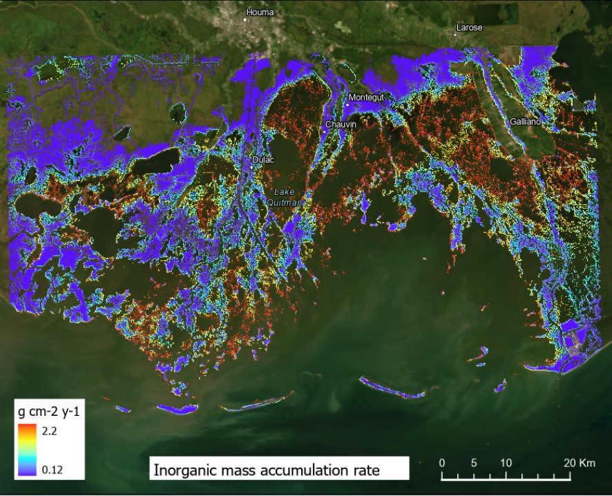
Figure 2. Inorganic mass accumulation rates (IMAR) in the Terrebonne Basin. Source: Terrebonne_IMAR.nc4
Data Access
These data are available through the Oak Ridge National Laboratory (ORNL) Distributed Active Archive Center (DAAC).
Delta-X: Delft3D Broad-Scale Sediment Model, Terrebonne Basin, MRD, Louisiana, USA
Contact for Data Center Access Information:
- E-mail: uso@daac.ornl.gov
- Telephone: +1 (865) 241-3952
References
Christensen, A.L., J.M. Mallard, J. Nghiem, M. Simard, T.M. Pavelsky, and M.P. Lamb. 2022. Delta-X: Acoustic Doppler Current Profiler Channel Surveys, MRD, Louisiana, 2021, V2. ORNL DAAC, Oak Ridge, Tennessee, USA. https://doi.org/10.3334/ORNLDAAC/2081
Cortese, L., and S. Fagherazzi. 2022. Fetch and distance from the bay control accretion and erosion patterns in Terrebonne marshes (Louisiana, USA). Earth Surface Processes and Landforms 47:1455–1465. https://doi.org/10.1002/esp.5327
Cortese, L., X. Zhang, and S. Fagherazzi. 2023. Delta-X: Delft3D Broad-Scale Sediment Model, Atchafalaya Basin, MRD, Louisiana, USA. ORNL DAAC, Oak Ridge, Tennessee, USA. https://doi.org/10.3334/ORNLDAAC/2302
Cortese, L., X. Zhang, M. Simard and S. Fagherazzi. 2023a. Quantifying the impact of storm frequency and intensity on mineral mass accumulation rates of coastal marshes. Journal of Geophysical Research: Earth Surface, in review.
Cortese, L., C. Donatelli, X. Zhang, J.A. Nghiem, M. Simard, C.E. Jones, M. Denbina, C.G. Fichot, J.P. Harringmeyer, and S. Fagherazzi. 2023b. Coupling numerical models of deltaic wetlands with AirSWOT, UAVSAR, and AVIRIS-NG remote sensing data. Biogeosciences, in review. https://doi.org/10.5194/bg-2023-108
Denbina, M.W., M. Simard, and E. Rodriguez. 2023. Delta-X: AirSWOT L2 Geocoded Water Surface Elevation, MRD, Louisiana, 2021, Version 2. ORNL DAAC, Oak Ridge, Tennessee, USA. https://doi.org/10.3334/ORNLDAAC/2128
Everett, T., Q. Chen, A. Karimpour, and R. Twilley. 2018. Quantification of Swell Energy and Its Impact on Wetlands in a Deltaic Estuary. Estuaries and Coasts 42:68–84. https://doi.org/10.1007/s12237-018-0454-z
Fichot, C.G., and J. Harringmeyer. 2022. Delta-X: AVIRIS-NG L3-derived Water Quality, TSS, and Turbidity, MRD, LA 2021, V2. ORNL DAAC, Oak Ridge, Tennessee, USA. https://doi.org/10.3334/ORNLDAAC/2112
Lesser, G.R., J.A. Roelvink, J.A. T.M. van Kester, and G.S. Stelling. 2004. Development and validation of a three-dimensional morphological model. Coastal Engineering 51:883–915. https://doi.org/10.1016/j.coastaleng.2004.07.014