Documentation Revision Date: 2025-12-03
Dataset Version: 1
Summary
There is one data file in netCDF format in this dataset.
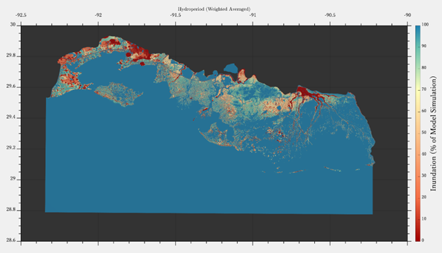
Figure 1. Weighted average hydroperiod derived from hydrodynamic model simulations for fall and spring 2021.
Citation
Payandeh, A.R., M. Simard, and C. Jones. 2025. Delta-X: Delft3D FM, Weighted Mean Hydroperiod, MRD, Louisiana, USA. ORNL DAAC, Oak Ridge, Tennessee, USA. https://doi.org/10.3334/ORNLDAAC/2421
Table of Contents
- Dataset Overview
- Data Characteristics
- Application and Derivation
- Quality Assessment
- Data Acquisition, Materials, and Methods
- Data Access
- References
Dataset Overview
This dataset provides the weighted average hydroperiod derived from two Delft3D Flexible Mesh (FM) model simulations representing the low discharge and high discharge seasons. A weighted averaging approach was applied to combine the outputs of two hydrodynamic models representing different river discharge conditions (Payendah et al., 2025a; high discharge for fall 2021 and low discharge for spring 2021) (Figure 1). The weights for each model were determined using the probability density function (PDF) of the Atchafalaya River discharge. Specifically, the weight coefficients were derived by comparing the PDFs of the mean discharge during the fall and spring simulations. This method allows the model results to be weighted according to the relative contribution of river discharge during each simulation, providing a more representative combined outcome based on historical discharge variability.
Project: Delta-X
The Delta-X mission is a 5-year NASA Earth Venture Suborbital-3 mission to study the Mississippi River Delta in the United States, which is growing and sinking in different areas. River deltas and their wetlands are drowning as a result of sea level rise and reduced sediment inputs. The Delta-X mission will determine which parts will survive and continue to grow, and which parts will be lost. Delta-X begins with airborne and in situ data acquisition and carries through data analysis, model integration, and validation to predict the extent and spatial patterns of future deltaic land loss or gain.
Related datasets
Payandeh, A.R., M. Simard, and C. Jones. 2025. Delta-X: Delft3D FM, Extended Domain Hydrodynamic Model. ORNL DAAC, Oak Ridge, Tennessee, USA. https://doi.org/10.3334/ORNLDAAC/2464
- This dataset provides the river discharge conditions.
Payandeh, A.R., M. Simard, and C. Jones. 2025. Delta-X: Delft3D FM, Weighted Mean Salinity, MRD, Louisiana, USA. ORNL DAAC, Oak Ridge, Tennessee, USA. https://doi.org/10.3334/ORNLDAAC/2420
- This dataset uses the same methods and is for the same time period and study area
Acknowledgements
This study was funded by the NASA Earth Venture Suborbital-3 Program (grant NH17ZDA001N-EVS3).
Data Characteristics
Spatial Coverage: Atchafalaya River and Terrebonne Basins in southern Louisiana, USA
Spatial Resolution: 25 m
Temporal Coverage: 2021-03-20 to 2021-09-14
Site Boundaries: Latitude and longitude are given in decimal degrees.
| Site | Westernmost Longitude | Easternmost Longitude | Northernmost Latitude | Southernmost Latitude |
|---|---|---|---|---|
| Atchafalaya River and Terrebonne Basins | -92.3434 | -90.2076 | 29.9336 | 28.7751 |
Data File Information
There is one file in netCDF format with this dataset: Delft3DFM_Weighted_Averaged_Hydroperiod.nc4
Table 1. Variables in the netCDF.
| Variable Name | Units | Description |
|---|---|---|
| wgs84 | - | WGS 84 coordinate system metadata |
| mesh2d | - | Topology data of 2D mesh |
| mesh2d_node_x | degrees east | x-coordinate (longitude) of mesh nodes |
| mesh2d_node_y | degrees north | y-coordinate (latitude) of mesh nodes |
| mesh2d_node_z | m | z-coordinate (altitude) of mesh nodes |
| mesh2d_edge_x | degrees east | Characteristic x-coordinate of the mesh edge (e.g., midpoint) |
| mesh2d_edge_y | degrees north | Characteristic y-coordinate of the mesh edge (e.g., midpoint) |
| mesh2d_edge_nodes | - | Start and end nodes of mesh edges |
| mesh2d_face_nodes | - | Vertex nodes of mesh faces (counterclockwise) |
| mesh2d_edge_faces | - | Neighboring faces of mesh edges |
| mesh2d_face_x | degrees east | Characteristic x-coordinate of mesh face |
| mesh2d_face_y | degrees north | Characteristic y-coordinate of mesh face |
| mesh2d_face_x_bnd | degrees east | x-coordinate bounds of mesh faces (corner coordinates) |
| mesh2d_face_y_bnd | degrees north | y-coordinate bounds of mesh faces (corner coordinates) |
| mesh2d_face_z | m | z-coordinate of mesh faces |
| mesh2d_Hydroperiod | percent | Frequency of inundation: weighted mean hydroperiod of the fall and spring simulations |
Application and Derivation
Delta-X begins with airborne and in situ data acquisition and carries through data analysis, model integration, and validation to predict the extent and spatial patterns of future deltaic land loss or gain. Hydrodynamic models such as the Delft3d FM (Deltares, 2025) are important to these processes in simulating river discharge conditions.
Quality Assessment
Not provided.
Data Acquisition, Materials, and Methods
Weighted Average of Model Results Based on River Discharge
To combine the outputs of two hydrodynamic models representing different river discharge conditions (Payendah et al., 2025a; high discharge for fall 2021 and low discharge for spring 2021), a weighted averaging approach was applied. The weights for each model were derived from the long-term probability density function (PDF) of the Atchafalaya River discharge (Figure 2). The PDF was calculated using hourly discharge data from 1996 to 2024, obtained from the USGS station at Morgan City (ID: 07381600). Specifically, the weight coefficients were derived by comparing the PDFs of the mean discharge during the fall and spring simulations. The density values were then evaluated at the mean discharge of the fall simulation (pdfmeanFall) and at the mean discharge of the spring simulation (pdfmeanSpring). The density values obtained were used to form the weights as follows:
This method allows the model results to be weighted according to the relative contribution of river discharge during each simulation, providing a more representative combined outcome based on historical discharge variability. Based on this method, the calculated weights for the fall and spring simulations were 0.74 and 0.26, respectively.
Refer to Payendah et al. (2025a) for additional model details.
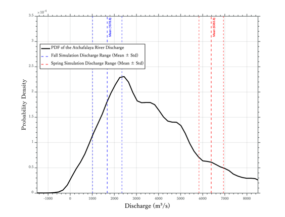
Figure 2. Probability density function (PDF) of Atchafalaya River discharge. Blue vertical lines represent the mean discharge ± standard deviation for the fall simulation, while red vertical lines indicate the mean discharge ± standard deviation for the spring simulation.
Data Access
These data are available through the Oak Ridge National Laboratory (ORNL) Distributed Active Archive Center (DAAC).
Delta-X: Delft3D FM, Weighted Mean Hydroperiod, MRD, Louisiana, USA
Contact for Data Center Access Information:
- E-mail: uso@daac.ornl.gov
- Telephone: +1 (865) 241-3952
References
Deltares. 2025. Delft3d FM user manual. Deltares; Delft, The Netherlands. https://content.oss.deltares.nl/delft3d/D-Flow_FM_User_Manual.pdf
Payandeh, A.R., M. Simard, and C. Jones. 2025a. Delta-X: Delft3D FM, Extended Domain Hydrodynamic Model. ORNL DAAC, Oak Ridge, Tennessee, USA. https://doi.org/10.3334/ORNLDAAC/2464
Payandeh, A.R., M. Simard, and C. Jones. 2025b. Delta-X: Delft3D FM, Weighted Mean Salinity, MRD, Louisiana, USA. ORNL DAAC, Oak Ridge, Tennessee, USA. https://doi.org/10.3334/ORNLDAAC/2420