Documentation Revision Date: 2023-09-29
Dataset Version: 1
Summary
This dataset includes 12 files in cloud-optimized GeoTIFF format.

Figure 1. Digital elevation model (DEM) for the Atchafalaya and Terrebonne Basins in Louisiana, USA.
Citation
Christensen, A.L., M.W. Denbina, and M. Simard. 2023. Delta-X: Digital Elevation Model, MRD, LA, USA, 2021. ORNL DAAC, Oak Ridge, Tennessee, USA. https://doi.org/10.3334/ORNLDAAC/2181
Table of Contents
- Dataset Overview
- Data Characteristics
- Application and Derivation
- Quality Assessment
- Data Acquisition, Materials, and Methods
- Data Access
- References
Dataset Overview
This dataset provides an updated digital elevation model (DEM) for the Atchafalaya and Terrebonne basins in coastal Louisiana, USA. The DEM is updated from the Pre-Delta-X DEM and extended to the full Delta-X study area. This DEM was developed from multiple data sources, including sonar data collected during Pre-Delta-X and Delta-X campaigns, bathymetric data from the Coastal Protection and Restoration Authority System-Wide Assessment and Monitoring System (CPRA SWAMP), and NOAA, and topography from the National Elevation Dataset and LiDAR from US Geological Survey (USGS). The provided data layers include the DEM, a binary water/land mask, data source flags, and eight layers with analysis weighting factors for each pixel. The weighting factors indicate how each data source contributed to this multisource DEM.
Project: Delta-X
The Delta-X mission is a 5-year NASA Earth Venture Suborbital-3 mission to study the Mississippi River Delta in the United States, which is growing and sinking in different areas. River deltas and their wetlands are drowning as a result of sea level rise and reduced sediment inputs. The Delta-X mission will determine which parts will survive and continue to grow, and which parts will be lost. Delta-X begins with airborne and in-situ data acquisition and carries through data analysis, model integration, and validation to predict the extent and spatial patterns of future deltaic land loss or gain.
Related dataset
Christensen, A.L., J.M. Mallard, J. Nghiem, J. Harringmeyer, M. Simard, T.M. Pavelsky, M.P. Lamb, and C.G. Fichot. 2022. Delta-X: Sonar Bathymetry Survey of Channels, MRD, Louisiana, 2021. ORNL DAAC, Oak Ridge, Tennessee, USA. https://doi.org/10.3334/ORNLDAAC/2085
Denbina, M.W., M. Simard, T.M. Pavelsky, A.I. Christensen, K. Liu, and C. Lyon. 2020. Pre-Delta-X: Channel Bathymetry of the Atchafalaya Basin, LA, USA, 2016. ORNL DAAC, Oak Ridge, Tennessee, USA. https://doi.org/10.3334/ORNLDAAC/1807
Acknowledgement
This project received funding from NASA Earth Venture Suborbital-3 Program (grant NNH17ZDA001N-EVS3).
Data Characteristics
Spatial Coverage: Achafalya and Terrebonne Basins of the Mississippi River Delta in coastal Louisiana, US
Spatial Resolution: 10 m
Temporal Coverage: 2021, using data sources from 2012 to 2021.
Temporal Resolution: One time estimate
Study Area: Latitudes and longitudes in decimal degrees
| Site | Westernmost Longitude | Easternmost Longitude | Northernmost Latitude | Southernmost Latitude |
|---|---|---|---|---|
| coastal Louisiana, US | -91.9078 | -90.150 | 29.958 | 28.973 |
Data File Information
This dataset includes 12 files in cloud-optimized GeoTIFF format (.tif).
Each GeoTIFF file has a single band holding data described in Table 1. The data are projected in UTM coordinates, zone 15 north (EPSG: 32615), in 10-m x 10-m pixels. The vertical datum for elevation values is NAVD88.
Table 1. Files with descriptions. Flag value cross-references analysis weight files with data sources in Table 2.
| Filename | Units | Description | Flag value |
|---|---|---|---|
| DeltaX_MultiSource_DEM_Atchafalaya-Terrebonne_Basin_2021_V1.tif | m | Interpolated elevation of bed (waterbodies) or land relative to the NAVD88 in meters. | - |
| DeltaX_MultiSource_DEM_Data_Source_Flag_V1.tif | - | Flags denoting data source for raster cells; see Table 2. | - |
| DeltaX_MultiSource_DEM_watermask_V1.tif | - | Binary mask denoting water (1) or land (0). | - |
| adh_weight_V1.tif | 1 | Analysis weight for ADH bathymetry. | 1 |
| atcha_weight_V1.tif | 1 | Analysis weight for lake bathymetry in Atchafalaya Basin | 9 |
| cpra_weight_V1.tif | 1 | Analysis weight for CPRA bathymetry. | 6 |
| deltax_sonar_weight_V1.tif | 1 | Analysis weight for Delta-X sonar data. | 3 |
| noaa_weight_V1.tif | 1 | Analysis weight for NOAA bathymetry data. | 5 |
| pre_deltax_sonar_weight_V1.tif | 1 | Analysis weight for Pre-Delta-X sonar data. | 2 |
| shaw_weight_V1.tif | 1 | Analysis weight for Shaw bathymetry data. | 4 |
| synthetic_carved_weight_V1.tif | 1 | Analysis weight for synthetic bathymetry for water bodies >1 ha. | 8 |
| topo_weight_V1.tif | 1 | Analysis weight for land topography data from USGS NED. | 0 |
Table 2. Data sources referenced by flag values in DeltaX_MultiSource_Data_Source_Flag_V1.tif.
| Data Source | General Area | Flag value | Citation |
|---|---|---|---|
| Land Topography | |||
| USGS 2012 | Atchafalaya Basin | 0 | USGS NED |
| USGS 2013 | Jean Lafitte | 0 | USGS NED |
| USGS 2015 | Terrebonne Basin | 0 | USGS NED |
| USGS 2017 | Upper Delta Plain, Chenier Plain | 0 | USGS NED |
| Shaw | Wax Lake Delta | 4 | Shaw et al. (2016) |
| NCALM Lidar | Wax Lake Delta | 1 | Nghiem (2022) |
| Lakes Bathymetry | |||
| CPRA SWAMP Terrebonne | Lake Salvador, Lake Cataouatche, Lac des Allemands, Bayou Perot, Lost Lake, Lake Mechant | 6 | Folse et al. (2020) |
| CPRA SWAMP Barataria | Caillou Lake, Bay Junop, Bay Long, King Lake, Bay Voisin, Hackberry Lake, Fiddlers Lake, and Lake Pagie | 6 | Folse et al. (2020) |
| Mean bed elevations of waterbodies on the Atchafalaya River floodplain | Multiple lakes in the Atchafalaya Basin | 9 | Kroes (2022) |
| Bay Bathymetry | |||
| NOAA 2012 | Entire coast | 5 | Love et al. (2012) |
| ADH | Atchafalaya Basin and west Terrebonne basin | 1 | Xing et al. (2017) |
| CPRA SWAMP Terrebonne | Terrebonne Bay | 6 | APTIM (2019, 2020) |
| CPRA SWAMP Atchafalaya | Atchafalaya and Vermillion Bay | 6 | APTIM (2019, 2020) |
| Channel Bathymetry | |||
| Pre Delta-X | Select channels in the Atchafalaya basin | 2 | Debina et al. (2020) |
| Delta-X | Select channels in the Atchafalaya and Terrebonne basins | 3 | Christensen et al. (2022) |
| CPRA SWAMP Channels | Select channels in the Terrebonne and Barataria basins | 6 | Folse et al. (2020) |
| Synthetic | Water bodies >1 hectare lacking bathymetry data were carved to -2 m NAVD88. | 8 | - |
| Mixed sources | Pixels where multiple sources were used to estimate elevation and no single source had an analysis weight >0.50 | -1 | - |
Application and Derivation
This multisource DEM is used as the input for hydrodynamic and sediment transport modeling.
Quality Assessment
None provided.
Data Acquisition, Materials, and Methods
A digital elevation model for the Atchafalaya and Terrebonne basins was developed by combining data from multiple sources.
Water Mask:
A binary water mask was developed to distinguish "land" from "water" pixels. The water mask was made using Normalized Difference Water Index (NDWI) values derived from the National Agriculture Imagery Program (NAIP) (Figure 2). NAIP data are available from 5 years: 2010, 2013, 2015, 2017, and 2019. For each year, NDWI was calculated using the green and near-infrared bands. A threshold value of 0.1 is used to delineate water and land. Pixels that were classified as water for at least 3 out of 5 NAIP years were considered to be permanent open water bodies.
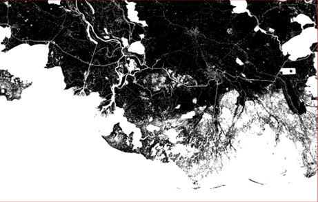
Figure 2. Initial water mask using a 0.1 NDWI threshold and a 3-year water classification threshold to determine permanent open water bodies (white) versus land (black).
A portion of the study area, near Wax Lake Delta (WLD), was not covered by NAIP. In addition, a large portion of the islands of WLD were classified as water. LiDAR data and Sentinel-2 data were used to reclassify portions of these islands as land and to improve the water mask in the WLD region.
 |
 |
| Figure 3. Corrected water mask for Wax Lake Delta. Left image shows initial mask derived from NAIP data. Right image shows corrected mask derived from Sentinel-1 data. Black = water, gray = land | |
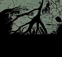
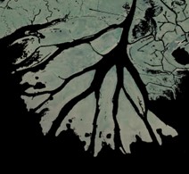
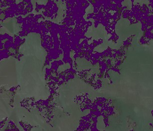
In the Terrebonne region, there are small marsh areas that are classified as water, but should be classified as land (Figure 4). LiDAR data from the USGS National Elevation Data were used to correct these marsh areas and reclassify some pixels from water to land in our final water mask (Figure 5).
 |
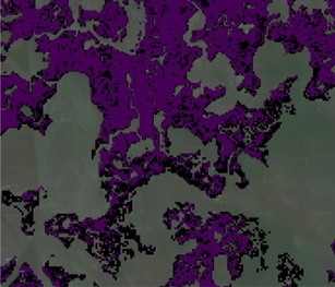 |
| Figure 4. Example of misclassified marsh pixels in Terrebonne basin. Left image shows initial classification (purple = land, gray = water) and right image shows LiDAR-corrected classification (black = pixels reclassifed as land) | |
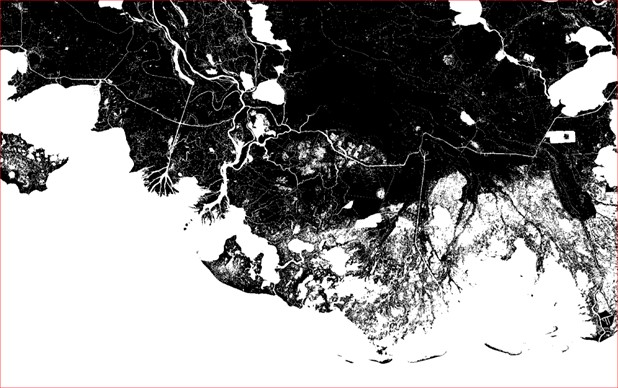
Figure 5. Final water mask for the Delta-X domain (DeltaX_MultiSource_DEM_watermask_V1.tif). White = water, black = land.
Land topography:
Elevations of land pixels were assigned using several topography datasets. The majority of data were derived from the USGS National Elevation Dataset. These data were collected in 2012, 2013, 2015, and 2017 (Figures 6-7). Over the WLD, aerial lidar data were collected by National Center for Airborne Laser Mapping (NCALM) in November 2020 (Nghiem 2022) (Figure 7). These lidar elevation values were averaged with the USGS NED data to obtain a final elevation values for WLD.
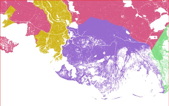
Figure 6. Available USGS LiDAR data from the National Elevation Dataset. Colors correspond to the year of data acquisition: 2012 = gold, 2013 = green, 2015 = purple, and 2017 = pink.
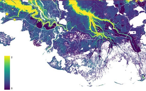
Figure 7. Land topography elevation from available USGS lidar data, scale is meters with respect to NAVD88
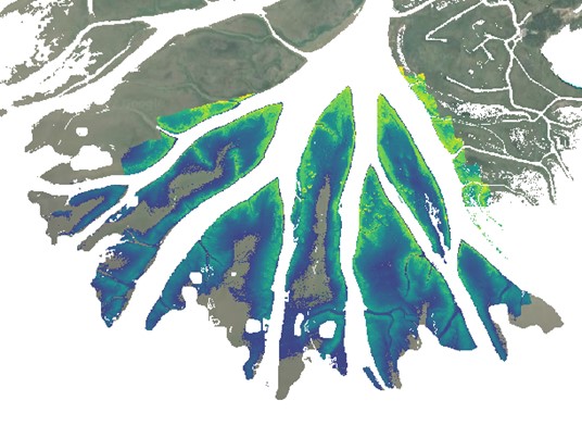
Figure 8. Land elevation for Wax Lake Delta derived from Nghiem (2022).
Water Bathymetry:
Bathymetric data from multiple sources were used for water pixels. For coastal areas including Vermillion Bay, Atchafalaya Bay, Terrebonne Bay, and a small portion of Barataria Bay, a combination of bathymetry data were used from Xing et al. (2017), NOAA National Centers for Environmental Information (Love et al. 2012), Shaw et al. (2016), and the CPRA System Wide Assessment and Monitoring Program (SWAMP, Folse et al., 2020).
Large lakes were surveyed in the CPRA SWAMP campaign, and bathymetry data were interpolated using an inverse difference weighting algorithm (Figure 9). These lakes include Lake Salvador, Lake Cataouatche, Lac des Allemands, Bayou Perot, Lost Lake, Lake Mechant, Caillou Lake, Bay Junop, Bay Long, King Lake, Bay Voisin, Hackberry Lake, Fiddlers Lake, and Lake Pagie.
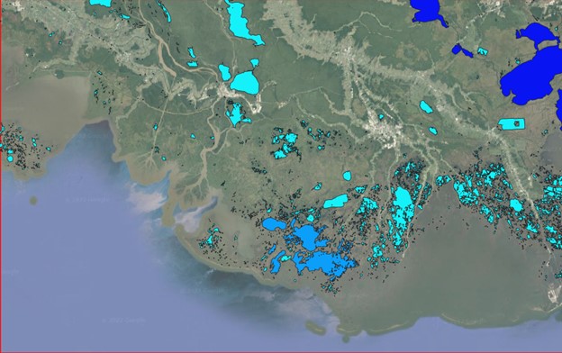
Figure 9. Large lakes in Delta-X study domain.
For channels, bayous, flooded wetlands, and other permanent water bodies in the water mask, the best available bathymetric dataset was used, including bathymetric survey data collected during the Pre-Delta-X campaign (Denbina et al., 2020), the Delta-X campaign (Christensen et al., 2021), and from CPRA SWAMP (APTIM 2019 and APTIM 2020). In those areas, sonar data were interpolated using inverse difference weighting. In the channels and delta front of Wax Lake Delta, data from Shaw et al. (2016) collected in 2010, 2011, 2012, and 2015, were used. In permanent water bodies of the Atchafalaya basin without sonar data, mean bed elevation from USGS (Kroes, 2022) was used.
In areas without reliable bathymetric data, synthetic data are created by carving water bodies greater than 1 hectare, and other selected areas, to at least -2 m NAVD88. Channel centerlines were also carved to improve connectivity between wetlands and the ocean.
Final DEM product:
Topography for land pixels and bathymetry for water pixels were merged to produce the final DEM (Figure 1). All elevation values were referenced to NAVD88. The dominant data source for each pixel can be found in DeltaX_MultiSource_Data_Source_Flag_V1.tif with reference to Table 2 (Figure 10). The weights files (Table 1), one for each of the nine data sources (Table 2), hold a value for each pixel that indicates the relative contribution of that data source to the pixel's elevation value in the final multisource DEM. Weight values range 0.0 to 1.0.
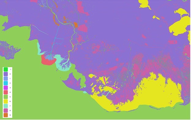
Figure 10. Sources of elevation data. Values in the map legend refer to files and data source listed in Tables 1-2 referenced by flag value.
Data Access
These data are available through the Oak Ridge National Laboratory (ORNL) Distributed Active Archive Center (DAAC).
Delta-X: Digital Elevation Model, MRD, LA, USA, 2021
Contact for Data Center Access Information:
- E-mail: uso@daac.ornl.gov
- Telephone: +1 (865) 241-3952
References
Aptim Environmental & Infrastructure, LLC (APTIM), 2020. System Wide Assessment and Monitoring Program (SWAMP): Phase IV-Geophysical Surveys from Four League Bay to Sabine Lake. Final Report prepared for Louisiana Coastal Protection and Restoration Authority. Contract 4400007082, Task 10: 409p. https://www.aptim.com/
Aptim Environmental & Infrastructure, LLC (APTIM), 2019. System Wide Assessment and Monitoring Program (SWAMP) Phase III Geophysical Surveys in Terrebonne Basin. Final Report prepared for Louisiana Coastal Protection and Restoration Authority. Contract 4400007082, Task 10: 421p. https://www.aptim.com/
Christensen, A.L., J.M. Mallard, J. Nghiem, J. Harringmeyer, M. Simard, T.M. Pavelsky, M.P. Lamb, and C.G. Fichot. 2022. Delta-X: Sonar Bathymetry Survey of Channels, MRD, Louisiana, 2021. ORNL DAAC, Oak Ridge, Tennessee, USA. https://doi.org/10.3334/ORNLDAAC/2085
Denbina, M.W., M. Simard, T.M. Pavelsky, A.I. Christensen, K. Liu, and C. Lyon. 2020. Pre-Delta-X: Channel Bathymetry of the Atchafalaya Basin, LA, USA, 2016. ORNL DAAC, Oak Ridge, Tennessee, USA. https://doi.org/10.3334/ORNLDAAC/1807
Folse, T.M., T.E. McGinnis, L.A. Sharp, J.L. West, M.K. Hymel, J.P. Troutman, D. Weifenbach, W.M. Boshart, L.B. Rodrigue, D.C. Richardi, W.B. Wood, C.M. Miller, E.M. Robinson, A.M. Freeman, C.L. Stagg, B.R. Couvillion, and H.J. Beck. 2020. A Standard Operating Procedures Manual for the Coastwide Reference Monitoring System-Wetlands and the System-Wide Assessment and Monitoring Program: Methods for Site Establishment, Data Collection, and Quality Assurance/Quality Control. Louisiana Coastal Protection and Restoration Authority. Baton Rouge, LA. https://cims.coastal.louisiana.gov/RecordDetail.aspx?Root=0&sid=24216
Kroes, D. E. 2022. Mean bed elevations of waterbodies on the Atchafalaya River floodplain. U.S. Geological Survey data release. https://doi.org/10.5066/P94GULXE
Love, M., C. Amante, L.A. Taylor, and K.S. Carignan. 2012. Digital Elevation Models of the Northern Gulf Coast: Procedures, Data Sources and Analysis. NOAA Technical Memorandum NESDIS NGDG-59. National Geophysical Data Center, Marine Geology and Geophysics Division; Boulder, Colorado. National Oceanic and Atmospheric Administration. https://ntrl.ntis.gov/NTRL/ (accession number PB2012108808, NTIS Issue 201226)
Nghiem, J. 2022. Sediment Accretion Rates and Spatial Patterns in the Wax Lake Delta, LA 2020. National Center for Airborne Laser Mapping (NCALM). Distributed by OpenTopography. https://doi.org/10.5069/G99W0CP6
Shaw, J.B., F. Ayoub, C.E. Jones, M.P. Lamb, B. Holt, R.W. Wagner, T.S. Coffey, J.A. Chadwick, and D. Mohrig. 2016. Airborne Radar Imaging of Subaqueous Channel Evolution in Wax Lake Delta, Louisiana, USA. Geophysical Research Letters 43:5035-5042. https://doi.org/10.1002/2016GL068770
USGS. 2021. National Elevation Dataset (NED). U.S. Geological Survey. https://apps.nationalmap.gov/
Xing, F., J.P.M. Syvitski, A.J. Kettner, E.A. Meselhe, J.H. Atkinson, and A.K. Khadka. 2017. Morphological responses of the Wax Lake Delta, Louisiana, to Hurricanes Rita. Elementa: Science of the Anthropocene 5:80. http://doi.org/10.1525/elementa.125