Documentation Revision Date: 2025-03-04
Dataset Version: 1
Summary
There is one data file in comma-separated values (.csv) format with this dataset.
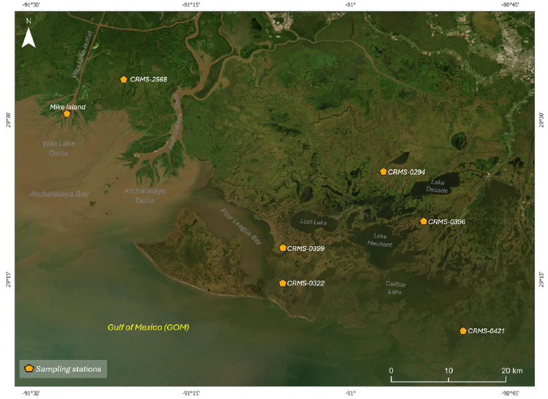
Figure 1. Delta-X sampling sites along a salinity gradient (freshwater, brackish, and saline marshes) in an active and inactive coastal basin in Louisiana. Site CRMS-0294 is a floating marsh in an inactive basin. Samples for 137Cs testing were not collected at that site.
Citation
Twilley, R., P. Biswas, A. Rovai, A.F. Cassaway, A.L. Christensen, I.A. Vargas-Lopez, and S. Kameshwar. 2025. Delta-X: Soil Accretion Rates from Cs-137 Activity and NUMAR Validation, MRD, LA. ORNL DAAC, Oak Ridge, Tennessee, USA. https://doi.org/10.3334/ORNLDAAC/2380
Table of Contents
- Dataset Overview
- Data Characteristics
- Application and Derivation
- Quality Assessment
- Data Acquisition, Materials, and Methods
- Data Access
- References
Dataset Overview
This dataset holds measurements of 137Cs activity sampled from sites in the Atchafalaya and Terrebonne Basins on the southern coast of Louisiana, USA. Sediment cores were taken to validate modeled estimates of soil accretion rates. The NUMAR model, developed by Twilley et al. (2024b), was designed to predict soil properties and corresponding accretion rates in marsh environments. This study explored whether the probabilistic outcomes generated by the model align with accretion rates determined through field-based measurements using 137Cs activity. The model's probabilistic simulations were conducted for active and inactive basins, encompassing fresh, brackish, and saline sites. Aliquots of approximately 5-9 g of finely ground dry sediment were placed into vials of known geometry for direct gamma counting of 137Cs using high-purity Germanium (Ge) well detectors. Additionally, several other soil properties had been compared with the field measures. The 137Cs dating technique is based on detecting the specific core section in which the radioactive isotope Cesium-137 peak activity occurs across a vertical soil profile. This peak corresponds to the peak fallout in 1963 deposited during the atmospheric nuclear testing (Pennington et al., 1973) and provides a timeline reference for estimating soil accumulation rates, sediment deposition, and marsh accretion (Ritchie and McHenry, 1990; Walling and He, 1997). Therefore, to validate the NUMAR accretion results, 137Cs activity was measured at different core sections across a vertical soil profile to determine the peak corresponding to the peak fallout in 1963 due to atmospheric nuclear testing and estimate soil accretion rates (Figures 2 and 3; Table 2). Since the results are reproducible using the algorithm discussed in Twilley et al. (2024b), this dataset does not include any additional data other than 137Cs activity for the selected sites.
Project: Delta-X
The Delta-X mission is a 5-year NASA Earth Venture Suborbital-3 mission to study the Mississippi River Delta in the United States, which is growing and sinking in different areas. River deltas and their wetlands are drowning as a result of sea level rise and reduced sediment inputs. The Delta-X mission will determine which parts will survive and continue to grow, and which parts will be lost. Delta-X begins with airborne and in situ data acquisition and carries through data analysis, model integration, and validation to predict the extent and spatial patterns of future deltaic land loss or gain.
Related Datasets
Castañeda-Moya, E., and E. Solohin. 2023. Delta-X: Soil Properties for Herbaceous Wetlands, MRD, Louisiana, 2021, V3. ORNL DAAC, Oak Ridge, Tennessee, USA. https://doi.org/10.3334/ORNLDAAC/2239
- Provides properties of soil core samples
Twilley, R., P. Biswas, A. Rovai, A.L. Christensen, A.F. Cassaway, and I.A. Vargas-Lopez. 2024a. Delta-X: NUMAR Soil Accretion Modeled to 2100, MRD, Louisiana, USA. ORNL DAAC, Oak Ridge, Tennessee, USA. https://doi.org/10.3334/ORNLDAAC/2368
- Provides modeled estimates of soil accretion for the Atchafalaya and Terrebonne basins for 2021-2100
Twilley, R., P. Biswas, A. Rovai, A.F. Cassaway, and I.A. Vargas-lopez. 2024b. Delta-X: NUMAR Predictive Model for Marsh Accretion Rates and Chemical Properties. ORNL DAAC, Oak Ridge, Tennessee, USA. https://doi.org/10.3334/ORNLDAAC/2354
- Provides input data and model code to run the NUMAR model
Twilley, R., A.F. Cassaway, A. Rovai, I.A. Vargas-Lopez, and J.A. Pineda-gomez. 2025. Delta-X: Feldspar Sediment Accretion Measurements, MRD, LA, USA, 2019-2023, Version 4. ORNL DAAC, Oak Ridge, Tennessee, USA. https://doi.org/10.3334/ORNLDAAC/2381
- Provides sediment accretion measurements collected from feldspar station
Twilley, R., A. Fontenot-Cassaway, and A. Rovai. 2022. Delta-X: Feldspar Sediment Accretion Measurements, MRD, LA, USA, 2019-2023, Version 3. ORNL DAAC, Oak Ridge, Tennessee, USA. https://doi.org/10.3334/ORNLDAAC/2290
- Provides sediment accretion measurements collected from feldspar station
Data Characteristics
Spatial Coverage: Atchafalaya and Terrebonne Basins, southern coast of Louisiana, USA
Temporal Coverage: Samples were collected for Active Fresh/Mike Island, CRMS 2568, Active Brackish (CRMS 0399), Active Saline (CRMS 0322) on 2021-09-23 and for Inactive Saline (CRMS 0421) on 2021-09-22. The sample Inactive Brackish CRMS (CRMS 0396) was collected in April 2023
Site Boundaries: Latitude and longitude are given in decimal degrees.
| Site | Westernmost Longitude | Easternmost Longitude | Northernmost Latitude | Southernmost Latitude |
|---|---|---|---|---|
| Atchafalaya and Terrebonne Basins | -91.4417 | -90.8225 | 29.5643 | 29.1714 |
There is one data file with this dataset: Soil_Cs137_Activity.csv. The variables are described below.
Table 1. Variables in the file Soil_Cs137_Activity.csv
| Column name | Unit | Description |
| Site | Sampling site | |
| Sample ID | ID assigned to the sample | |
| Sampling_Date | YYYY-MM-DD | Date of sampling |
| Latitude | degrees_north | Latitude of sampling site in decimal degrees |
| Longitude | degrees_east | Longitude of sampling site in decimal degrees |
| Depth_Range | cm | Represents the corresponding depth of the soil section in the soil column |
| Sample_Depth | cm | The deeper depth of the soil sample section was assigned as the sample depth |
| Cs137 | dpm g−1 | Represents the activity of Cesium-137 (137Cs) measured in disintegrations per minute per gram of soil |
| Error | dpm g−1 | Represents the uncertainty or instrumental error margin in measuring Cesium-137 activity (137Cs). This error accounts for potential variations in the measurement process and provides an estimate of the confidence in the reported 137Cs activity values. |
Data Notes:
| Cs branching ratio for 662 keV | 0.851 |
| detector 4 efficiency: | 0.0205 |
| detector 3 efficiency: | 0.05 |
Application and Derivation
Delta-X begins with airborne and in situ data acquisition and carries through data analysis, model integration, and validation to predict the extent and spatial patterns of future deltaic land loss or gain. Measured soil accretion rates from Cs-137 activity in soil cores were used to validate modeled estimates of soil accretion rates.
Quality Assessment
The methodology and QA conform to that of Maiti et al. (2010) as follows:
Aliquots of approximately 5–9 g of finely ground dry sediment were placed into vials of known geometry for direct gamma counting of 137Cs using high-purity Germanium (Ge) well detectors. Detector efficiency was determined using EPA standards sand spiked with a NIST (National Institute of Standards and Technology) traceable mixed gamma liquid standard from Analytics™, Inc. The gamma-ray spectra were analyzed using the Canberra gamma-analysis software, focusing on peak area and position. All measured activities were decay-corrected to the sample collection midpoint, with 137Cs identified by its 661 keV emission. Errors represent counting statistics, and the error associated with curve fitting routine.
Data Acquisition, Materials, and Methods
Long-term Soil Accretion (137Cs Activity Based Field Measurements)
The 137Cs dating technique, generally applied to date wetland sedimentary deposits, was used for sample analysis. This technique is based on detecting the specific core section in which the radioactive isotope Cesium-137 peak activity occurs across a vertical soil profile. This peak corresponds to the peak fallout in 1963 deposited during the atmospheric nuclear testing (Pennington et al., 1973) and provides a timeline reference for estimating soil accumulation rates, sediment deposition, and marsh accretion (Ritchie and McHenry, 1990; Walling and He, 1997). Therefore, to validate the NUMAR accretion results, 137Cs activity was measured at different core sections across a vertical soil profile to determine the peak corresponding to the 1963 nuclear testing and estimate soil accretion rates (Figures 2 and 3; Table 2).
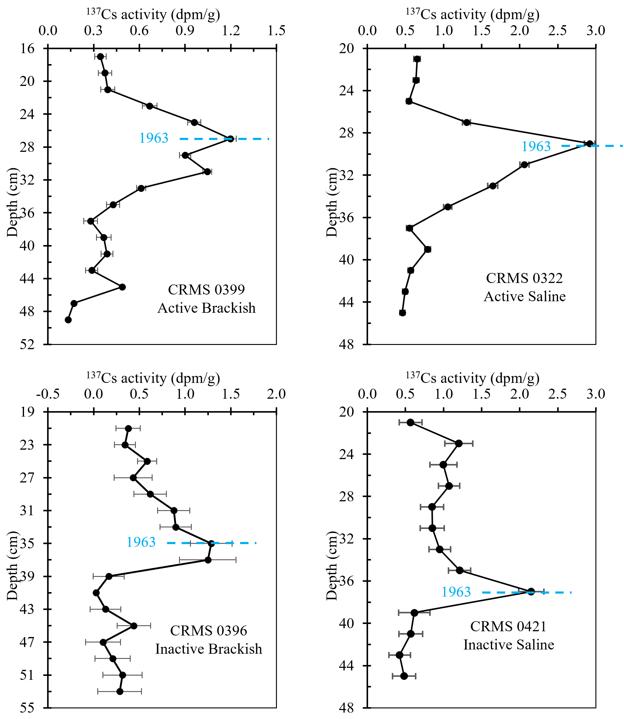
Figure 2. 137Cs activity (dpm/g) profile for active and inactive basin's brackish and saline sites.
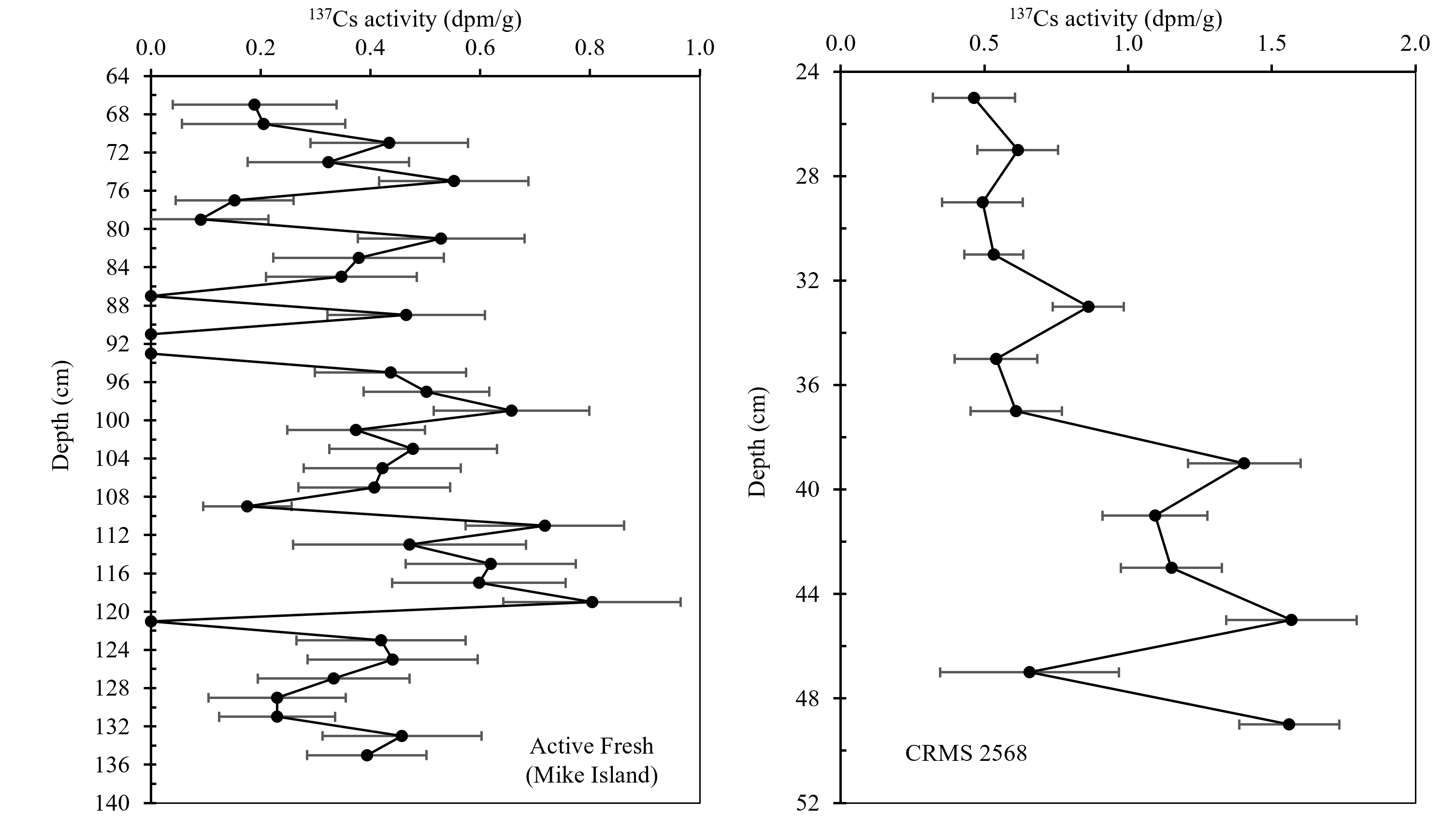
Figure 3. 137Cs activity profile for Mike Island (Active Fresh) and CRMS 2568.
Table 2. Soil accretion rate based on 137Cs activity measurements in the soil core samples. Asterisks (*) indicates samples collected using a Russian Peat Corer (RPC) to reduce the soil compaction during sampling. Sites included in the tables are active brackish (CRMS 0399), active saline (CRMS 0322), inactive brackish (CRMS 396), and inactive saline (CRMS 0421).
| Site | Years since 1963 | Compaction (cm) | Cs peak depth (cm) | Soil Accretion rate (cm y-1) |
Compaction corrected Soil Accretion Rate (cm y-1) |
|---|---|---|---|---|---|
| 399 | 58 | 3.81 | 27 | 0.47 | 0.53 |
| 322 | 58 | 1.27 | 29 | 0.50 | 0.52 |
| 0396* | 60 | 0.00 | 36 | 0.60 | 0.60 |
| 421 | 58 | 5.08 | 37 | 0.64 | 0.73 |
In Mike Island (Active Fresh) and CRMS 2568, no reliable 137Cs peak was obtained during sample analysis (Figure 3), while in CRMS 0294 (floating marsh), samples for 137Cs analysis were not collected. Delta evolution stages and biological activity can be used to explain the outcome:
- Mike Island (Active Fresh): The low 137Cs activity suggests the core maybe from a sandy area, where radionuclides like 137Cs and 210Pb don't adhere well, making dating difficult. The weak signal at 120 cm is unreliable due to low activity and large error bars, further indicating challenges in using this core for accurate sediment dating. Additionally, the Wax Lake Delta complex began to form sub-aqueously in 1950, and the sub-aerial part started to form in 1973 due to elevated sediment transport (Roberts, 1998; Twilley et al., 2019). This might be the reason for the absence of a distinguishable 137C peak in the active basin.
- CRMS 2568: The distinct layers of 137Cs activity above and below 38 cm suggest some stratification; however, the absence of a clear peak indicates potential disturbances in the sediment. This could be due to mixing processes such as bioturbation, which may have redistributed the 137Cs and obscured the expected peak, suggesting the core may be from a disturbed area.
- CRMS 0294: For the floating marsh in the inactive basin, no samples were collected for 137Cs testing. A similar fresh floating site (BA 3166) in the Barataria basin has a 0.32 cm yr-1 (210Pb) accretion rate (Baustian et al., 2021). Sites near Terrebonne parish, brackish/saline sites have soil accretion rates (137Cs activity based) ranging from 0.67 cm yr-1 to 1.33 cm yr-1 with a mean of 0.98 cm yr-1 (Nyman et al., 1993).
Comparison with Model Results
Twilley et al. (2024b) incorporated organic and inorganic loading rate as inputs in the model based on Delta-X campaign from Fall 2020 to Fall 2022 (Twilley et al., 2022) and Cassaway et al. (2024). In this study, for comparison, all feldspar Delta-X campaigns from Fall 2020 to 2023 (Twilley et al., 2025) were used to determine the input variables organic and inorganic matter loading rate, respectively. A probabilistic analysis NUMAR (Twilley et al., 2024b) was performed for the selected sites.
The same method as described in Cassaway et al. (2024) was used to determine the organic and inorganic loading rates in the intertidal zones for Delta-X feldspar campaign from Fall 2020 to Fall 2023. This involves data processing and linear regression to find the annual vertical accretion rates over feldspar marker (Figure 4). Using the information, the organic and inorganic loading rates were determined (Figure 5). A similar calibration to Twilley et al. (2024b) was required to find the root turnover rates. Since the loading rates were close to previous, no significant change in the result was observed. Organic and inorganic matter loading rates and calibrated root turnover rates are included in Table 3.
Since the results are reproducible using the algorithm discussed in Twilley et al. (2024b), this dataset does not include any additional data other than 137Cs activity for selected sites. Figure 6 compares the model’s probabilistic outcomes with field measurements and previous assessment.
Table 3. Annual vertical accretion rate over feldspar (VAR), organic matter loading rate (oms), inorganic matter loading rate (si), and respective calibrated root turnover rates (kr) for the campaign periods Fall 2020 to Fall 2022 (F'20-22) and Fall 2020 to Fall 2023 (F'20-23). For oms and si, mean is followed by standard deviation in parentheses. Asterisks (*) indicate values taken from Cassaway et al. (2024) and daggers (†) denote previously calibrated values from Twilley et al. (2024b).
| Site | VAR (cm y-1) | oms (g cm-2 y-1) | si (g cm-2 y-1) | kr (y-1) | ||||
|---|---|---|---|---|---|---|---|---|
| F’20-22 | F’20-23 | F’20-22 | F’20-23 | F’20-22 | F’20-23 | F’20-22 | F’20-23 | |
| Active Fresh | 2.14* | 2.87 | 0.0436 (0.0060)* | 0.0602 (0.0285) | 0.7248 (0.4290)* | 0.7093 (0.5129) | 0.65† | 0.53 |
| Active Brackish | 0.78* | 0.92 | 0.0336 (0.0115)* | 0.0404 (0.0184) | 0.0976 (0.0430)* | 0.1116 (0.074) | 0.95† | 1.04 |
| Active Saline | 1.12* | 1.21 | 0.0508 (0.0152)* | 0.0566 (0.0246) | 0.0961 (0.0492)* | 0.1048 (0.0557) | 0.58† | 0.6 |
| Inactive Fresh | 1.24* | 1.15 | 0.0298 (0.0096)* | 0.0279 (0.0104) | 0.0128 (0.0060)* | 0.0124 (0.0063) | 0.04† | 0.04 |
| Inactive Brackish | 1.41* | 1.34 | 0.0460 (0.0269)* | 0.044 (0.0229) | 0.0670 (0.0269)* | 0.0755 (0.0657) | 2.65† | 2.96 |
| Inactive Saline | 2.94* | 2.55 | 0.1028 (0.0366)* | 0.0923 (0.0242) | 0.4097 (0.1680)* | 0.3500 (0.1198) | 2.02† | 1.75 |
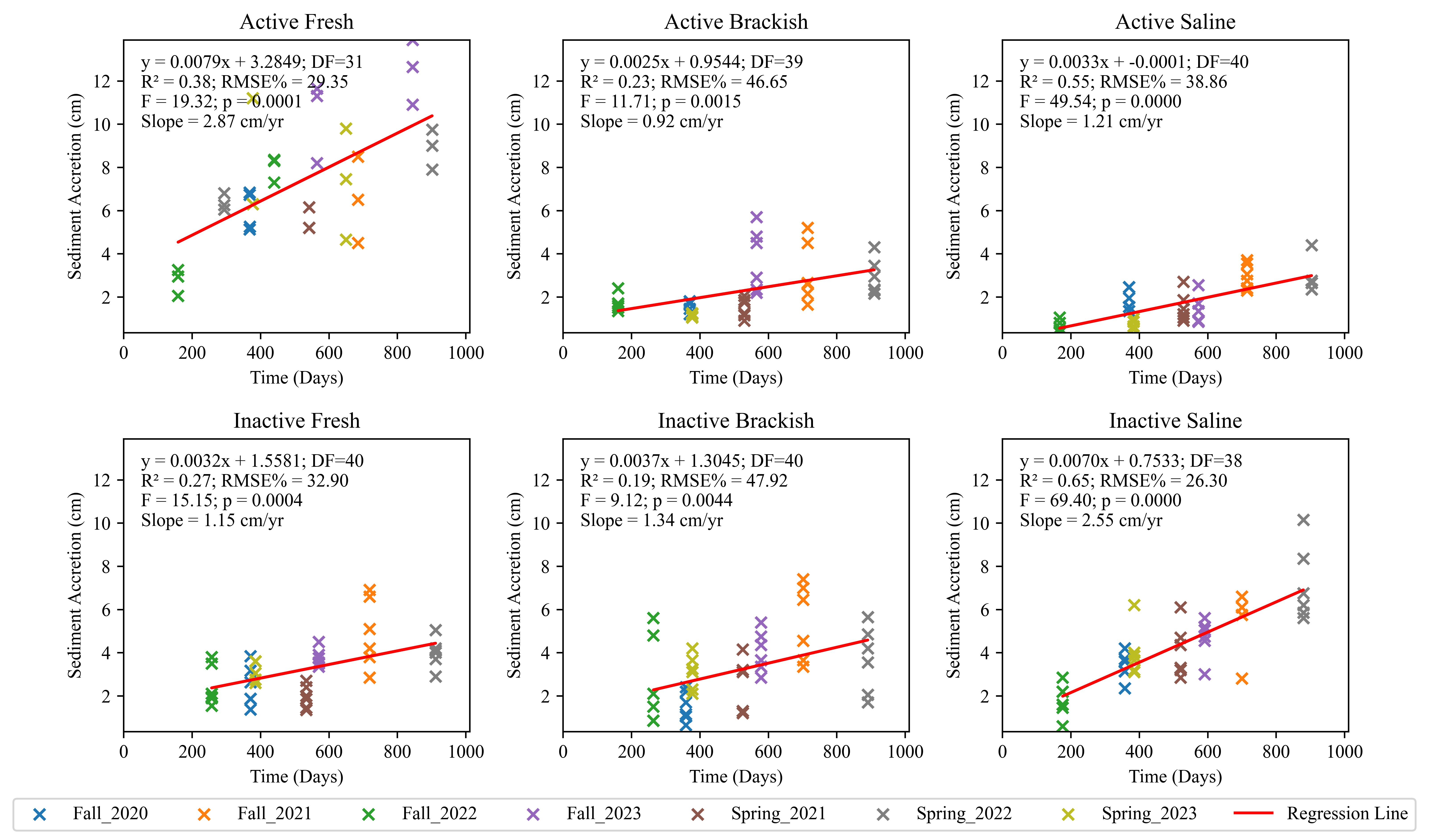
Figure 4. Vertical accretion rate measurement for Fall 2020 to Fall 2023 campaign periods. For details about regression method, please refer to Cassaway et al. (2024).
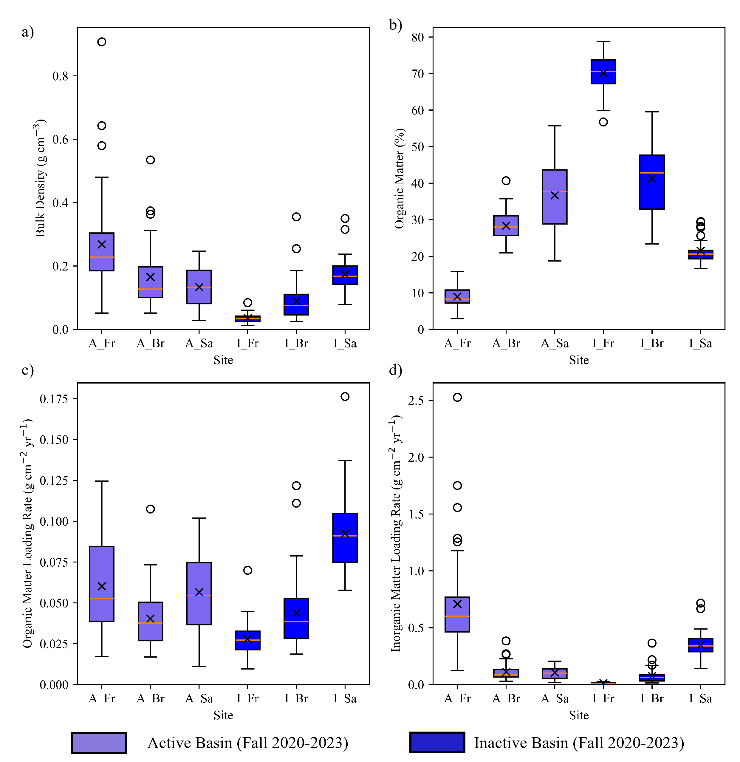
Figure 5. a) Bulk density (g cm-3), b) organic matter content (%) in the accreted soil over feldspar, c) organic matter loading rate (g cm-2 y-1), and d) inorganic matter loading rate (g cm-2 y-1), for Delta-X campaign (Fall 2020 - Fall 2023). (A- active basin, B- Inactive Basin, Fr – freshwater, Br – Brackish, and Sa – Saline sites).
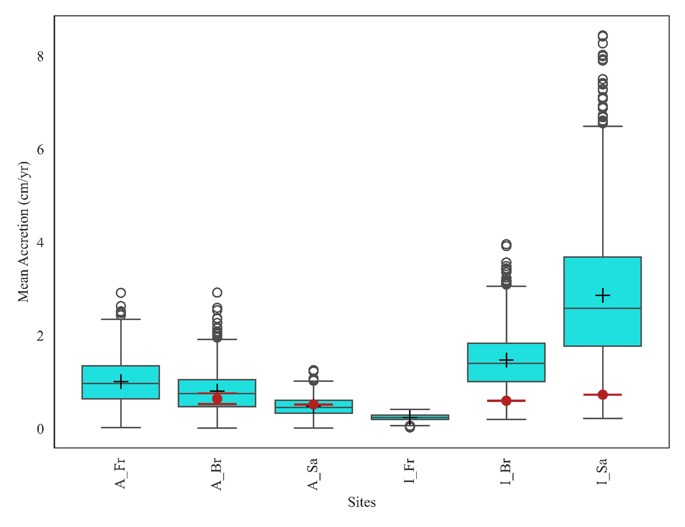
Figure 6. Accretion rates from NUMAR probabilistic outcomes for the study sites (A- active basin, B- Inactive Basin, Fr – freshwater, Br – Brackish & Sa – Saline sites). Solid red dot and whisker represent the field observations based on 137Cs activity field data by this study and For Active Brackish site, it included average soil accretion based on 137Cs from Baustian et al. (2021).
For detailed information on the formulation of the NUMAR model and its probabilistic Monte Carlo simulations, please refer to Twilley et al. (2024b) and Biswas (2024).
Data Access
These data are available through the Oak Ridge National Laboratory (ORNL) Distributed Active Archive Center (DAAC).
Delta-X: Soil Accretion Rates from Cs-137 Activity and NUMAR Validation, MRD, LA
Contact for Data Center Access Information:
- E-mail: uso@daac.ornl.gov
- Telephone: +1 (865) 241-3952
References
Baustian, M.M., C.L. Stagg, C.L. Perry, L.C. Moss, and T.J.B. Carruthers. 2021. Long-Term Carbon Sinks in Marsh Soils of Coastal Louisiana are at Risk to Wetland Loss. Journal of Geophysical Research: Biogeosciences, 126(3), e2020JG005832. https://doi.org/10.1029/2020JG005832
Biswas, P. 2024. Developing the Next Generation of Models for Predicting Soil Formation in Mangrove (NUMAN 2.0) and Marsh (NUMAR 2.0) Wetlands [Master of Science, Louisiana State University]. https://doi.org/10.31390/gradschool_theses.6008
Cassaway, A.F., R.R. Twilley, A.S. Rovai, and G.A. Snedden. 2024. Patterns of marsh surface accretion rates along salinity and hydroperiod gradients between active and inactive coastal deltaic floodplains. Estuarine, Coastal and Shelf Science, 301, 108757. https://doi.org/10.1016/j.ecss.2024.108757
Castañeda-Moya, E., and E. Solohin. 2023. Delta-X: Soil Properties for Herbaceous Wetlands, MRD, Louisiana, 2021, V3. ORNL DAAC, Oak Ridge, Tennessee, USA. https://doi.org/10.3334/ORNLDAAC/2239
Maiti, K., J. Carroll, and C.R. Benitez-Nelson. 2010. Sedimentation and particle dynamics in the seasonal ice zone of the Barents Sea. Journal of Marine Systems 79:185–198. https://doi.org/10.1016/j.jmarsys.2009.09.001
Nyman, J., R. DeLaune, H. Roberts, and W. Patrick. 1993. Relationship between vegetation and soil formation in a rapidly submerging coastal marsh. Marine Ecology Progress Series 96:269–279. https://doi.org/10.3354/meps096269
Pennington, W., T.G. Tutin, R.S. Cambray, and E.M. Fisher. 1973. Observations on Lake Sediments using Fallout 137Cs as a Tracer. Nature 242:324–326. https://doi.org/10.1038/242324a0
Ritchie, J.C., and J.R. McHenry. 1990. Application of Radioactive Fallout Cesium-137 for Measuring Soil Erosion and Sediment Accumulation Rates and Patterns: A Review. Journal of Environmental Quality 19:215–233. https://doi.org/10.2134/jeq1990.00472425001900020006x
Roberts, H.H. 1998. Delta switching: early responses to the Atchafalaya River diversion. Journal of Coastal Research 14:882-899. https://www.jstor.org/stable/4298842
Twilley, R., A.F. Cassaway, A. Rovai, I.A. Vargas-Lopez, and J.A. Pineda-gomez. 2025. Delta-X: Feldspar Sediment Accretion Measurements, MRD, LA, USA, 2019-2023, Version 4. ORNL DAAC, Oak Ridge, Tennessee, USA. https://doi.org/10.3334/ORNLDAAC/2381
Twilley, R., P. Biswas, A. Rovai, A.L. Christensen, A.F. Cassaway, and I.A. Vargas-Lopez. 2024a. Delta-X: NUMAR Soil Accretion Modeled to 2100, MRD, Louisiana, USA. ORNL DAAC, Oak Ridge, Tennessee, USA. https://doi.org/10.3334/ORNLDAAC/2368
Twilley, R., P. Biswas, A. Rovai, A.L. Christensen, A.F. Cassaway, I.A. Vargas-Lopez, and S. Kameshwar. 2024b. Delta-X: NUMAR Predictive Model for Marsh Accretion Rates and Chemical Properties. ORNL DAAC, Oak Ridge, Tennessee, USA. https://doi.org/10.3334/ORNLDAAC/2354
Twilley, R., A. Fontenot-Cassaway, and A. Rovai. 2022. Delta-X: Feldspar Sediment Accretion Measurements, MRD, LA, USA, 2019-2023, Version 3. ORNL DAAC, Oak Ridge, Tennessee, USA. https://doi.org/10.3334/ORNLDAAC/2290
Twilley, R.R., J.W. Day, A.E. Bevington, E. Castañeda-Moya, A. Christensen, G. Holm, L.R. Heffner, R. Lane, A. McCall, A. Aarons, S. Li, A. Freeman, and A.S. Rovai. 2019. Ecogeomorphology of coastal deltaic floodplains and estuaries in an active delta: Insights from the Atchafalaya Coastal Basin. Estuarine, Coastal and Shelf Science 227:106341. https://doi.org/10.1016/j.ecss.2019.106341
Walling, D.E., and Q. He. 1997. Use of fallout 137Cs in investigations of overbank sediment deposition on river floodplains. CATENA 29:263–282. https://doi.org/10.1016/S0341-8162(96)00072-0