Documentation Revision Date: 2023-09-15
Dataset Version: 1
Summary
There is one file in comma-separated values (CSV) format.
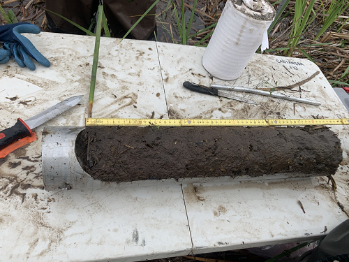
Figure 1. Root biomass sample (top 50 cm of soils) collected using a gouge soil auger.
Citation
Castañeda-Moya, E., and E. Solohin. 2023. Delta-X: Root Stable Isotopes from Herbaceous Wetlands, MRD, LA, USA, August 2021. ORNL DAAC, Oak Ridge, Tennessee, USA. https://doi.org/10.3334/ORNLDAAC/2193
Table of Contents
- Dataset Overview
- Data Characteristics
- Application and Derivation
- Quality Assessment
- Data Acquisition, Materials, and Methods
- Data Access
- References
Dataset Overview
This dataset contains carbon-13 (13C) and nitrogen-15 (15N) isotopic signatures of belowground root biomass samples from herbaceous wetlands in the Atchafalaya and Terrebonne basins of the Mississippi River Delta in coastal Louisiana, U.S., during August 2021. The data were collected during the Delta-X Fall deployment. Field measurements were conducted at three sites in the Atchafalaya basin and three sites in the Terrebonne basin. Five of the sites are adjacent to sites from the Coastwide Reference Monitoring System (CRMS). The other site is located in Wax Lake Delta (WLD) without appropriate adjacent CRMS sites. Herbaceous wetland sites in both basins were chosen to represent a salinity gradient including freshwater, brackish, and saline ecosystems. Root biomass samples were collected using a gouge soil auger. Bulk isotopic signatures in living fine roots were measured with a mass spectrometer coupled to an elemental analyzer.
Project: Delta-X
The Delta-X mission is a 5-year NASA Earth Venture Suborbital-3 mission to study the Mississippi River Delta in the United States, which is growing and sinking in different areas. River deltas and their wetlands are drowning as a result of sea level rise and reduced sediment inputs. The Delta-X mission will determine which parts will survive and continue to grow, and which parts will be lost. Delta-X begins with airborne and in-situ data acquisition and carries through data analysis, model integration, and validation to predict the extent and spatial patterns of future deltaic land loss or gain.
Related Dataset
Castañeda-Moya, E., and E. Solohin. 2022. Delta-X: Aboveground Biomass and Necromass across Wetlands, MRD, Louisiana, 2021, V2. ORNL DAAC, Oak Ridge, Tennessee, USA. https://doi.org/10.3334/ORNLDAAC/2237
Castañeda-Moya, E., and E. Solohin. 2022. Delta-X: Belowground Biomass and Necromass across Wetlands, MRD, LA, USA, 2021, V2. ORNL DAAC, Oak Ridge, Tennessee, USA. https://doi.org/10.3334/ORNLDAAC/2238
Acknowledgments
This study was funded by the NASA Science Mission Directorate’s Earth Science Division through the Earth Venture Suborbital-3 Program NNH17ZDA001N-EVS3 (grant 17-EVS3-17_1-0009).
Data Characteristics
Spatial Coverage: Atchafalaya and Terrebonne Basins and the Wax Lake Delta (WLD), Louisiana, U.S.
Spatial Resolution: Points
Temporal Coverage: 2021-08-19 to 2021-08-27
Temporal Resolution: One-time estimates
Study Area: Latitude and longitude are given in decimal degrees.
| Site | Westernmost Longitude | Easternmost Longitude | Northernmost Latitude | Southernmost Latitude |
|---|---|---|---|---|
| Atchafalaya and Terrebonne Basins | -91.8852 | -90.8219 | 29.5102 | 29.1714 |
Data File Information
There is one in comma-separated value (*.csv) format: DeltaX_Belowground_Roots_Stable_Isotopes_Fall2021.csv
Table 1. Variable names and descriptions in the data file.
| Variable | Units | Description |
|---|---|---|
| basin | “Atchafalaya” or “Terrebonne” | |
| campaign | "Fall_2021" | |
| date | YYYY-MM-DD | Date that sample was collected |
| latitude | degrees_north | Location (latitude) of sampling site in decimal degrees |
| longitude | degrees_east | Location (longitude) of sampling site in decimal degrees |
| site | Site name | |
| hydrogeomorphic_zone | "High Intertidal", "Intermediate Intertidal", or "Intertidal" | |
| sampling_station | Sampling station | |
| core_id | Core replicate | |
| depth_interval | Core depth interval in cm (e.g., "0-10", "10-20", "20-30", "30-40", "40-50"); text format. Note that roots were not found at each depth interval at every sampling_station | |
| 15N | ‰ (per mille) | δ15N, 15N isotopic signature, or Nitrogen-15 (15N) isotope content of live fine roots in per mille as relative to the international standards and atmospheric air |
| 13C | ‰ (per mille) | δ13C, 13C isotopic signature, or Carbon-13 (13C) isotope content of live fine roots in per mille as relative to the international standards and atmospheric air |
Application and Derivation
Belowground (roots) isotopic signatures estimates will be used to assess how the intrasystem nutrient cycling of plant roots changes in response to different environmental conditions.
Quality Assessment
Replicate cores were sampled at different soil intervals at all sites and used to compute an average. Root C and N bulk isotopic signatures (δ13C, δ15N) analyses were performed using duplicate analytical replicates of each sample and the run precision was determined based on the relative percent difference between replicates at an acceptance limit of <5%. Accuracy was determined by the analysis of certified standard reference material during each run. Acceptable limits for accuracy were ±5%. Data outside these limits was not used.
Data Acquisition, Materials, and Methods
This Fall 2021 field study was conducted across the Atchafalaya and Terrebonne basins of coastal Louisiana to assess changes in belowground root dynamics with seasonality along salinity and soil nutrient gradients. The study was conducted during the period of 19-27 August 2021; these date range corresponds to the period of peak vegetation biomass and a period of low river discharge.
At each herbaceous wetland site, duplicate sampling stations (30 m apart) were established parallel to the wetland edge at 25 and 50 m within the intertidal zone to capture within site variability in belowground biomass. Due to a variety of elevation ranges within the Mike Island wetland site in the Wax Lake Delta (WLD), duplicate stations were established in the high and intermediate intertidal zones. In each sampling station, duplicate (0-50 cm depth) root cores were collected adjacent to aboveground biomass plots using a modified soil gouge auger (11 cm diameter x 50 cm length). Root cores were gently extruded, divided into 10-cm intervals and stored on ice in plastic bags for further analyses.
All root core samples were processed separately and initially rinsed with water through a 1-mm synthetic mesh screen to remove soil particles. Roots were separated into live (biomass) and dead (necromass) fractions within 4-6 weeks after collection. Live roots were separated by hand picking those floating in freshwater and were easily distinguished from necromass because of their buoyancy, turgor, and color. Live roots were sorted into diameter size classes of fine (<2 mm) and coarse (>2 mm) roots.
Root C and N bulk isotopic signatures (δ13C, δ15N) were analyzed for live fine roots (<2 mm) only using a Thermo Scientific Delta V Plus CF-IRMS coupled to a Carlo-Erba 1108 elemental analyzer via a ConFlo IV interface (Thermo Fisher Scientific, Waltham, MA, USA). Stable isotope data are reported in δ13C (‰) and δ15N (‰) per-mille notation as relative to the international standards and atmospheric air (Sulzman 2007).
Study Sites
Five out of the six selected sites for field measurements were part of the Coastal Reference Monitoring System (CRMS; Steyer et al., 2003) and they are labeled with the prefix ‘CRMS’ in the site name. The other site ('Mike Island') was in the Wax Lake Delta (WLD) without an adjacent CRMS site (Figure 2).
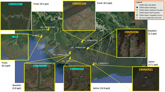
Figure 2. Study site locations in the Mississippi River Delta in coastal Louisiana, U.S. Sites with labels beginning "CRMS" are part of the Coastwide Reference Monitoring System (Steyer et al., 2003). "WLD"=Wax Lake Delta.
Data Access
These data are available through the Oak Ridge National Laboratory (ORNL) Distributed Active Archive Center (DAAC).
Delta-X: Root Stable Isotopes from Herbaceous Wetlands, MRD, LA, USA, August 2021
Contact for Data Center Access Information:
- E-mail: uso@daac.ornl.gov
- Telephone: +1 (865) 241-3952
References
Castañeda-Moya, E., and E. Solohin. 2022. Delta-X: Aboveground Biomass and Necromass across Wetlands, MRD, Louisiana, 2021, V2. ORNL DAAC, Oak Ridge, Tennessee, USA. https://doi.org/10.3334/ORNLDAAC/2237
Castañeda-Moya, E., and E. Solohin. 2022. Delta-X: Belowground Biomass and Necromass across Wetlands, MRD, LA, USA, 2021, V2. ORNL DAAC, Oak Ridge, Tennessee, USA. https://doi.org/10.3334/ORNLDAAC/2238
Steyer, G.D., C.E. Sasser, J.M. Visser, E.M. Swenson, J.A. Nyman, and R.C. Raynie. 2003. A proposed coast-wide reference monitoring system for evaluating wetland restoration trajectories in Louisiana. Coastal Monitoring through Partnerships. Environmental Monitoring and Assessment 81:107–117. https://doi.org/10.1023/A:1021368722681
Sulzman, E.W. 2007. Stable isotope chemistry and measurement: a primer. In R. Michener and K. Lajtha (eds). Stable Isotopes in Ecology and Environmental Science. Blackwell Publishing; Wiley Online Library. https://doi.org/10.1002/9780470691854.ch1