Documentation Revision Date: 2022-06-03
Dataset Version: 1.2
Summary
All roots were separated into live (biomass) and dead (necromass) fractions within 4–6 weeks after collection. Live roots were separated by handpicking those floating in freshwater and were easily distinguished from necromass because of their buoyancy, turgor, and color. Live roots were sorted into diameter size classes of fine (<2 mm) and coarse (>2 mm) roots. Each root sample was oven-dried at 60 degrees C to a constant mass and weighed using a standard laboratory semi-analytical balance (0.01 g precision). Root samples (BGB only) for duplicate cores for each depth interval within each hydrogeomorphic (HGM) zone were combined for carbon and nutrient analyses.
There are two data files in comma-separated value (*.csv) format included in this dataset.
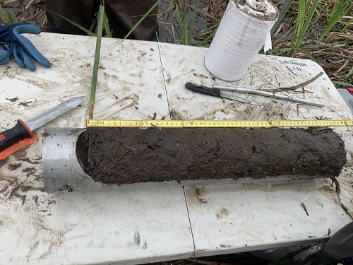
Figure 1. Root biomass sample (top 50 cm of soils) collected using a gouge soil auger.
Citation
Castañeda-Moya, E., and E. Solohin. 2022. Delta-X: Belowground Biomass and Necromass across Wetlands in the MRD, LA, USA, 2021. ORNL DAAC, Oak Ridge, Tennessee, USA. https://doi.org/10.3334/ORNLDAAC/1999
Table of Contents
- Dataset Overview
- Data Characteristics
- Application and Derivation
- Quality Assessment
- Data Acquisition, Materials, and Methods
- Data Access
- References
- Dataset Revisions
Dataset Overview
This dataset contains total carbon, total nitrogen, and total phosphorus content of belowground biomass (BGB) and necromass (BGN) samples collected from herbaceous wetlands in the Atchafalaya and Terrebonne basins of the Mississippi River Delta in southeastern coastal Louisiana, U.S., during March and August 2021. Field measurements were conducted at three sites in the Atchafalaya basin and three sites in the Terrebonne basin. Five of the sites are adjacent to sites from the Coastwide Reference Monitoring System (CRMS). The other site is in the Wax Lake Delta (WLD) without appropriate adjacent CRMS sites. Herbaceous wetland sites in both basins were chosen to represent a salinity gradient including freshwater, brackish, and saline ecosystems. Root biomass samples were collected using a gouge soil auger (Fig. 1).
All roots were separated into live (biomass) and dead (necromass) fractions within 4–6 weeks after collection. Live roots were separated by handpicking those floating in freshwater and were easily distinguished from necromass because of their buoyancy, turgor, and color. Live roots were sorted into diameter size classes of fine (<2 mm) and coarse (>2 mm) roots. Each root sample was oven-dried at 60 degrees C to a constant mass and weighed using a standard laboratory semi-analytical balance (0.01 g precision). Root samples (BGB only) for duplicate cores for each depth interval within each hydrogeomorphic (HGM) zone were combined for carbon and nutrient analyses.
Project: Delta-X
The Delta-X mission is a 5-year NASA Earth Venture Suborbital-3 mission to study the Mississippi River Delta in the United States, which is growing and sinking in different areas. River deltas and their wetlands are drowning as a result of sea level rise and reduced sediment inputs. The Delta-X mission will determine which parts will survive and continue to grow, and which parts will be lost. Delta-X begins with airborne and in-situ data acquisition and carries through data analysis, model integration, and validation to predict the extent and spatial patterns of future deltaic land loss or gain.
Related Dataset
Castañeda-Moya, E., and E. Solohin. 2022. Delta-X: Aboveground Biomass and Necromass across Wetlands, MRD, Louisiana, 2021. ORNL DAAC, Oak Ridge, Tennessee, USA. https://doi.org/10.3334/ORNLDAAC/2000
Acknowledgments
This work was supported by NASA Earth Venture Suborbital-3 Program (EVS-3; grant NNH17ZDA001N-EVS3).
Data Characteristics
Spatial Coverage: Atchafalaya and Terrebonne Basins and the Wax Lake Delta (WLD), Louisiana, U.S.
Spatial Resolution: Points.
Temporal Coverage: 2021-03-21 to 2021-08-27
Temporal Resolution: One-time estimates
Study Area: Latitude and longitude are given in decimal degrees.
| Site | Westernmost Longitude | Easternmost Longitude | Northernmost Latitude | Southernmost Latitude |
|---|---|---|---|---|
| Atchafalaya and Terrebonne Basins | -91.88524 | -90.8219 | 29.51016 | 29.17143 |
Data File Information
There are two data files in comma-separated value (*.csv) format included in this dataset: DeltaX_Belowground_Biomass_Necromass_Spring2021.csv and DeltaX_Belowground_Biomass_Necromass_Fall2021.csv.
Data File Details
Data not collected, analyzed, or recorded are represented by -9999 for numeric data and NA for text data.
Table 1. Variable names and descriptions in the data files.
| Variable | Units | Description |
|---|---|---|
| basin | “Atchafalaya” or “Terrebonne” | |
| campaign | Spring 2021 | |
| date | YYYY-MM-DD | Date collected: March 2021 |
| latitude | decimal degrees | Location (latitude) of sampling site |
| longitude | decimal degrees | Location (longitude) of sampling site |
| site | Site name | |
| hydrogeomorphic_zone | "Supratidal" or "Intertidal" | |
| sampling_station | Sampling station | |
| core_id | Core replicate | |
| depth_interval | cm | Core depth interval |
| root_class | Biomass (BGB) or necromass (BGN) | |
| root_biomass | g m-2 | Total dry mass of belowground root material per unit area |
| total_carbon | mg g-1 | Total carbon content per unit dried mass of root material |
| total_nitrogen | mg g-1 | Total nitrogen content per unit dried mass of root material |
| total_phosphorus | mg g-1 | Total phosphorus content per unit dried mass of root material |
| notes | Data note where applicable: For total_carbon, total_nitrogen, total_phosphorus, see C1 Value-composite sample |
Application and Derivation
Belowground root biomass and necromass data will be used to calibrate and validate an ecogeomorphic (NUMAR) model. Root data will also be used to generate in situ estimates of BGB, BGN, and root size class distribution with soil depth across all Delta-X sites. These data along with aboveground vegetation biomass will be used to generate root to shoot ratios to assess biomass and carbon partitioning between aboveground and belowground compartments across all sites in response to environmental conditions and seasonality.
Quality Assessment
Four replicate root cores (two cores in each sampling station) were collected at each HGM zone at all sites and used to compute an average. Carbon and nutrient analyses were determined using duplicate analytical replicates of each sample and the run precision was determined based on the relative percent difference between replicates at an acceptance limit of <5%. Accuracy and quality control were determined by the analysis of certified standard reference material during each run. Acceptable limits for accuracy were ±5%. Data outside these limits was not used and samples were re-run to obtain new accurate values.
Data Acquisition, Materials, and Methods
Study Sites
The Spring and Fall 2021 field deployments was conducted across the Atchafalaya and Terrebonne basins of the Mississippi River Delta in coastal Louisiana to assess belowground root dynamics in response to seasonality, soil properties, and river discharge regimes (low vs. high) across different hydrogeomorphic (HGM) zones. Field measurements were conducted at three sites in the Atchafalaya basin and three sites in the Terrebonne basin. Five of the sites are adjacent to sites from the Coastwide Reference Monitoring System (CRMS). The other site is in the Wax Lake Delta (WLD) without appropriate adjacent CRMS sites. The deployments were conducted during March and August as these periods correspond to the early phase of the vegetation growing season and the peak of the spring river flood season, and August-September is considered the period of peak biomass and a period of low river discharge.
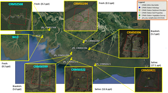
Figure 2. Study site locations in the Mississippi River Delta in coastal Louisiana, U.S. Sites with labels beginning "CRM" are part of the Coastwide Reference Monitoring System (Steyer et al., 2003). "WLD"=Wax Lake Delta.
Sample Collections & Analysis
Root biomass and necromass were evaluated at the same sites used to estimate aboveground biomass and vegetation structure using standard protocols published by Castañeda-Moya et al. (2011). In each sampling station, duplicate (0–50 cm depth) root cores were collected adjacent to aboveground biomass/necromass plots using a modified soil gouge auger (11 cm diameter x 50 cm length). Root cores were gently extruded, divided into 10 cm intervals and stored on ice in plastic bags for further analyses.
To estimate root biomass and necromass, all root core samples were processed separately and initially rinsed with water through a 1 mm synthetic mesh screen to remove soil particles. All roots were separated into live (biomass) and dead (necromass) fractions within 4–6 weeks after collection. Live roots were separated by hand picking those floating in freshwater and were easily distinguished from necromass because of their buoyancy, turgor, and color. Live roots were sorted into diameter size classes of fine (<2 mm) and coarse (>2 mm) roots. Each root sample was oven-dried at 60 degrees C to a constant mass and weighed using a standard laboratory semi-analytical balance (0.01 g precision). Total root biomass (fine and coarse combined) and necromass estimates were expressed in g m-2.
Root samples (BGB only) for duplicate cores for each depth interval within each HGM zone were combined for carbon and nutrient analyses. Samples were ground with a Wiley Mill to pass through a 40 µm mesh screen and stored separately in glass scintillation vials. Total carbon (TC) and total nitrogen (TN) concentrations of plant tissue were determined for each sample with a NA1500 elemental analyzer (Fisons, Instruments, Inc., Danvers, MA). Total P (TP) was extracted using an acid digested (HCl) extraction and concentrations determined by colorimetric analysis (EPA Methods 365.4 and 365.2; EPA 1983; see https://www.nemi.gov). Carbon and nutrient content (mg g-1) of fine roots accounted for 80-90% of the total root biomass for all sites.
Data Access
These data are available through the Oak Ridge National Laboratory (ORNL) Distributed Active Archive Center (DAAC).
Delta-X: Belowground Biomass and Necromass across Wetlands in the MRD, LA, USA, 2021
Contact for Data Center Access Information:
- E-mail: uso@daac.ornl.gov
- Telephone: +1 (865) 241-3952
References
EPA 1983. Method 365.4: Total phosphorous (Colorimetric, automated, block digester AA II): U.S. Environmental Protection Agency, Washington, DC. https://www.epa.gov/sites/default/files/2015-08/documents/method_365-4_1974.pdf
Castañeda-Moya, E., R.R. Twilley, V. Rivera-Monroy, B.D. Marx, C. Coronado-Molina, and S.M.L. Ewe. 2011. Patterns of root dynamics in mangrove forests along environmental gradients in the Florida Coastal Everglades, USA. Ecosystems 14:1178–1195. https://doi.org/10.1007/s10021-011-9473-3
Steyer, G.D., C.E. Sasser, J.M. Visser, E.M. Swenson, J.A. Nyman, and R.C. Raynie. 2003. A proposed coast-wide reference monitoring system for evaluating wetland restoration trajectories in Louisiana. Coastal Monitoring through Partnerships. Environmental Monitoring and Assessment 81:107–117. https://doi.org/10.1023/A:1021368722681
Dataset Revisions
| Version | Release Date | Description |
|---|---|---|
| 1.2 | 2022-06-03 | This release corrects a formatting issue for values within the depth_interval attribute. |
| 1.1 | 2022-05-12 | This release provides data from samples collected during the Delta-X Fall Campaign for the period August 19–August 27 as well as the spring data from Version 1.0. |
| 1.0 | 2022-04-17 | This release provided data for the Delta-X Spring Campaign conducted during the period of March 19 to April 2, 2021. |