Documentation Revision Date: 2024-05-28
Dataset Version: 1
Summary
This dataset contains 14 NetCDF (*.nc), four files in comma separated values format (*.csv), two GeoTIFFs (*.tif), and two MP4 videos (*.mp4) files.
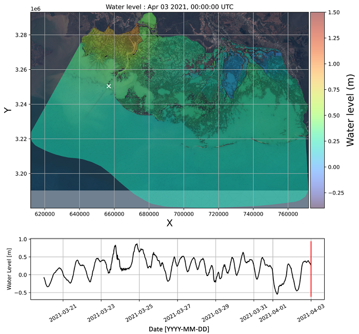
Figure 1: Snapshot of the water surface elevation in the model domain.
Citation
Soloy, A., A.L. Christensen, D.J. Jensen, M.W. Denbina, K.A. Wright, P. Passalacqua, and M. Simard. 2024. Delta-X: ANUGA Hydrodynamic Outputs, Atchafalaya and Terrebonne, MRD, USA. ORNL DAAC, Oak Ridge, Tennessee, USA. https://doi.org/10.3334/ORNLDAAC/2310
Table of Contents
- Dataset Overview
- Data Characteristics
- Application and Derivation
- Quality Assessment
- Data Acquisition, Materials, and Methods
- Data Access
- References
Dataset Overview
This dataset comprises the primary inputs and outputs from the ANUGA hydrodynamic model for spring 2021 (2021-03-20 to 2021-04-04). These dates align with the 2021 Delta-X Spring Campaign. Data cover the Atchafalaya and Terrebonne basins of the Mississippi River Delta in southern Louisiana, USA. ANUGA is a 2D depth-integrated hydrodynamic model which uses the Finite Volume Method (FVM) to numerically solve the shallow water momentum and continuity equations for fluid flow in broad-scale geophysical systems. The inputs consist of a modified digital elevation (DEM) model from Christensen et al. (2023a), a spatial classification of the friction coefficient modified after Jensen et al. (2023), and the model's unstructured grid with boundary condition locations. The model's outputs include two weeks of predictions of water levels and mean horizontal velocities at each mesh node at a 30-minute time step. Outputs are provided in NetCDF (*.nc) format and inputs are provided in GeoTIFF (*.tif) and comma separate (*.csv) format. Also included are MP4 videos (*.mp4) that provide visual summaries of the outputs.
Project: Delta-X
The Delta-X mission is a 5-year NASA Earth Venture Suborbital-3 mission to study the Mississippi River Delta in the United States, which is growing and sinking in different areas. River deltas and their wetlands are drowning as a result of sea level rise and reduced sediment inputs. The Delta-X mission will determine which parts will survive and continue to grow, and which parts will be lost. Delta-X begins with airborne and in situ data acquisition and carries through data analysis, model integration, and validation to predict the extent and spatial patterns of future deltaic land loss or gain.
Related Datasets
Wright, K.A., and P. Passalacqua. 2024. Delta-X: Calibrated ANUGA Hydrodynamic Outputs for the Atchafalaya Basin. ORNL DAAC, Oak Ridge, Tennessee, USA. https://doi.org/10.3334/ORNLDAAC/2306
Acknowledgments
This work was supported by NASA Earth Venture Suborbital-3 (EVS-3) program (grant NNH17ZDA001N-EVS3).
Data Characteristics
Spatial Coverage: Atchafalaya and Terrebonne basins, Mississippi River Delta, Louisiana, USA
Spatial Resolution: 30 m to 10 km
Temporal Coverage: 2021-03-20 to 2021-04-04
Temporal Resolution: 30 minutes
Site Boundaries: Latitude and longitude are given in decimal degrees.
| Site | Westernmost Longitude | Easternmost Longitude | Northernmost Latitude | Southernmost Latitude |
|---|---|---|---|---|
| Atchafalaya and Terrebonne basins | -91.86 | -90.19 | 29.76 | 28.72 |
Data File Information
The output files contained in this dataset are 14 NetCDF (*.nc) and two MP4 videos (*.mp4) files. Input files include four comma separated values (*.csv) files and two GeoTIFF (*.tif) files.
Results were derived using the ANUGA hydrodynamic model from Roberts et al. (2015).
Output files
The NetCDF files contain predictions of water levels and mean horizontal velocities at each mesh node at a 30-minute time step.
Files are named: anuga_outputs_atchafalaya-terrebonne_spring_YYYY-MM-DD_V1.0.nc, where YYYY-MM-DD is the date for the data being analyzed.
Files use the spatial reference system (SRS) for UTM zone 15N (EPSG: 32615, WGS84 datum).
Table 1. Data dictionary for anuga_outputs_atchafalaya-terrebonne_spring_YYYY-MM-DD_V1.0.nc files.
| Variable | Units | Description |
|---|---|---|
| projection_x_coordinate | m | X coordinate in WGS84 / UTM zone 15N |
| projection_y_coordinate | m | Y coordinate in WGS84 / UTM zone 15N |
| mesh_triangles | Triangle vertex coordinate indices. This parameter is called 'volumes' in ANUGA original outputs | |
| time | seconds | Seconds since 2021/03/02 00:00:00 |
| water_surface_height_above_reference_datum | m | Water Surface Height, (vertical, datum NAVD 88). This parameter is called 'stage' in ANUGA original outputs |
| bed_elevation | m | Bed elevation. This parameter is called 'elevation' in ANUGA original outputs |
| x_velocity | m s-1 | Eastward depth averaged water velocity. This variable was calculated from the parameters called “xmomentum”, “stage” and “elevation” in the ANUGA original outputs, using the following equation: x_velocity = xmomentum/(stage-elevation) |
| y_velocity | m s-1 | Northward depth averaged water velocity. This variable was calculated from the parameters called “ymomentum”, “stage” and “elevation” in the ANUGA original outputs, using the following equation: y_velocity = ymomentum/(stage-elevation) |
Also included are two MP4 videos (*.mp4) that summarize the outputs:
- anuga_outputs_atchafalaya-terrebonne_spring_water_velocity_video.mp4
- Contains the evolution of the depth averaged water velocity as predicted in the model over the course of the analysis. X and Y axes are in meters and based on WGS 84 / UTM zone 15N (EPSG: 32615).
- anuga_outputs_atchafalaya-terrebonne_spring_water_level_video.mp4
- Contains the evolution of the water surface elevation as predicted in the model over the course of the analysis. X and Y axes are in meters and based on WGS 84 / UTM zone 15N (EPSG: 32615).
Input Files
Input files document the data necessary to derive the output files. All files use the CRS UTM 15N (EPSG: 32615) with NAVD 88 vertical datum. Files include:
- anuga_input_atchafalaya-terrebonne_DEM.tif
- Contains a digital elevation model of the study area in meters.
- Data sources: Topo-Bathymetry from Christensen et al. (2023a), Topo-Bathymetry from NOAA (2012), and Mississippi River Centerlines from Christensen et al. (2023b)
- anuga_input_atchafalaya-terrebonne_friction_classification_map.tif
- Contains indices of the 9 classes of bed cover classes used for friction factor assignation into the model:
- 1: Offshore water
- 2: Large channel water
- 3: Narrow channel water
- 4: Lake water
- 5: Forest
- 6: Broadleaf herbaceous
- 7: Freshwater grasses
- 8: Saltmarsh grasses
- 9: Submerged/floating aquatic vegetation
- Sources: Vegetation cover map from Jensen et al.(2023), Watermask from Christensen et al. (2023a), and Mississippi River Centerlines from Christensen et al. (2023b)
- Contains indices of the 9 classes of bed cover classes used for friction factor assignation into the model:
- anuga_input_atchafalaya-terrebonne_mesh_nodes.csv
- Contains X and Y coordinates of the mesh nodes computed using OceanMesh2D
- Note: This file is headerless. The first column represents the X coordinate and the second the Y coordinates. The units are meters.
- Source: OceanMesh2D from Pringle et al (2021).
- anuga_input_atchafalaya-terrebonne_mesh_triangles.csv
- Contains the three indices of a triangle's vertices, from the mesh nodes table, computed using OceanMesh2D
- Note: This is a headerless file containing three columns.
- Source: OceanMesh2D from Pringle et al (2021).
- anuga_input_atchafalaya-terrebonne_tide_BC_mesh_indices.csv and anuga_input_atchafalaya-terrebonne_wall_BC_mesh_indices.csv
- Each row provides the index of the row and column from the mesh triangles table. The resulting points are used to identify the triangles where tide and wall boundary conditions are applied.
- Note: This file is headerless. This first column contains the row from the mesh triangles table (anuga_input_atchafalaya-terrebonne_mesh_triangles.csv) and the second column contains the column that was used from the mesh triangles table.
Application and Derivation
The hydrodynamic model predicts the variability of the water surface elevation and related water flow velocities given a set of boundary conditions, including river discharges and tidal oscillations. It is defined on a meshed domain of known elevation that includes both the Atchafalaya and Terrebonne basins, during the Spring season.
Quality Assessment
Model validation
Model validation was conducted by comparing the predicted water levels with those observed simultaneously through:
- 68 in situ gauges from the Coastwide Reference Monitoring System (CRMS) (CPRA, 2023) - as shown in Figures 2a and 3a.
- AirSWOT L3 datasets at three dates and times (Denbina et al., 2023) - as depicted in Figures 2b and 3b.
The results revealed a coefficient of determination R2 ranging between 0.6 and 0.77, an RMSE of 0.1 m to 0.28 m, and a bias ranging from -0.03 m to -0.1 m, depending on the means of observation.
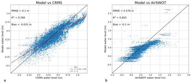
Figure 2. Model validation results calculated with CRMS in situ water level gauges (a) and AirSWOT remotely sensed water surface elevations at 3 different times (b)
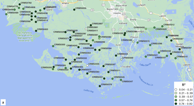
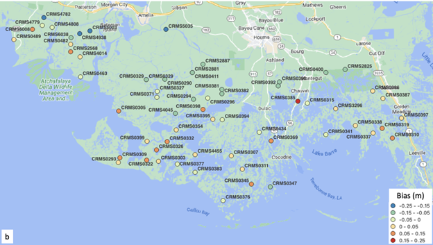
Figure 3. Spatial variability of the model validation metrics with respect to the CRMS water level gauges: R2 (a) and bias (b)
Data Acquisition, Materials, and Methods
DEM modifications
This model implementation employs a modified version of the DEM presented by Chirstensen et al. (2023a). The modifications were performed as follows:
- DEMs from both Chirstensen et al. (2023a) and NOAA (2012) were merged using a nearest-neighbor interpolation approach to extend coverage southward, where the DEM from Chirstensen et al. (2023a) lacked information (Figure 4).
- The Mississippi River Centerlines dataset from Christensen et al. (2023b) was utilized to ensure connectivity within the network of wetland channels. The DEM was carved to a -4 m (NAVD 88) elevation along the river centerlines wherever it was shallower.
- To correct for the overestimated elevation resulting from LIDAR measurements of the ground elevation through vegetation, the DEM was uniformly lowered by 30 cm.
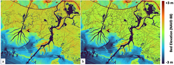
Figure 4. Sample of the DEM centered on the Atchafalaya region before (a) and after (b) modifications
Model implementation:
The model utilizes an unstructured grid comprising 3,117,413 points, forming 6,230,911 triangles. This grid was generated using the OceanMesh2D MATLAB package (Pringle et al., 2021) with the modified DEM as the primary input. A slope-wise approach was employed to optimally refine or relax the grid resolution within a range of 10 km to 30 m.
The hydrodynamic inputs are provided to the model as two-week-long time series, including:
- Discharge of the Wax Lake Outlet at Calumet (USGS, 2023b), imposed on the transect between points (657207.0, 3286377.0) and (657382.0, 3286322.0) (UTM zone 15N, EPSG:32615).
- Discharge of the Atchafalaya River at Morgan City (USGS, 2023b), imposed on the transect between points (672677.0, 3286188.0) and (673074.0, 3286358.0) (UTM zone 15N, EPSG:32615).
- Tidal water levels at Eugene Island (NOAA, 2023), applied along the southern domain boundary as defined in 'anuga_input_atchafalaya-terrebonne_tide_BC_mesh_indices.csv.'
The tidal input was adjusted downward by an empirically estimated elevation of 37 cm to align water levels with the NAVD 88 datum (K. Wright, personal communication, 2022). An additional -5 cm adjustment was made to account for tidal wave transformation between the actual gauge location and the boundary where it is applied in the model.
Friction calibration:
In the model, water dynamics are calibrated through empirical adjustments of the bed friction parameter. ANUGA employs a friction classification map to assign user-defined friction factor values to each class. In this model implementation, friction for non-vegetated classes is computed using the Manning formulation (Roberts et al., 2015). In vegetated areas, friction is calculated using the Baptist Equation (Baptist et al., 2007), as adapted for ANUGA by Wright (2022), to account for the heterogeneous vegetation drag within the domain.
The friction classification map (Figure 5) combines vegetation classes from Jensen et al. (2023), along with a segmentation of the water mask and river centerlines from Christensen et al. (2023a, 2023b), based on channel width and connectivity:
- Large rivers are channels wider than 150 m and directly connected to the sea.
- Lakes are bodies of water wider than 500 m but not directly connected to the sea.
- Small channels encompass all remaining water pixels not classified in any of the previous classes.
Friction factors, specifically Manning's N for non-vegetated regions and the Density Calibration Factor for vegetated regions, were empirically calibrated using a trial-and-error approach. The values presented in Table 2 yielded the highest coefficient of determination (R2) and the lowest Root Mean Square Error (RMSE) among all tested scenarios. Vegetation metrics (stem height, diameter, and density) were measured in situ by Castañeda-Moya and Solohin (2021). As no measurements were available for the aquatic vegetation species, this class was calibrated using the Manning N.
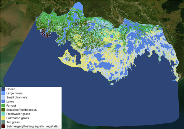
Figure 5. Friction classification map
Table 2. Calibrated friction values per class
| Class | Manning’s N (-) | Vegetation stem height (m) | Vegetation stem diameter (m) | Vegetation stem density (m^-2) | Density calibration factor (-) |
|---|---|---|---|---|---|
| Ocean | 0.012 | - | - | - | - |
| Large rivers | 0.022 | - | - | - | - |
| Small channels | 0.001 | - | - | - | - |
| Lakes | 0.001 | - | - | - | - |
| Forests | - | 12.91 | 0.191 | 0.3 | 0.011 |
| Broadleaf herbaceous | - | 0.22 | 0.007 | 53 | 0.004 |
| Freshwater grass | - | 0.4 | 0.002 | 1352 | 0.01 |
| Saltmarsh grass | - | 0.52 | 0.004 | 610 | 0.0025 |
| Tall grass | - | 1.05 | 0.011 | 208 | 0.01 |
| Aquatic vegetation | 0.001 | - | - | - | - |
Data Access
These data are available through the Oak Ridge National Laboratory (ORNL) Distributed Active Archive Center (DAAC).
Delta-X: ANUGA Hydrodynamic Outputs, Atchafalaya and Terrebonne, MRD, USA
Contact for Data Center Access Information:
- E-mail: uso@daac.ornl.gov
- Telephone: +1 (865) 241-3952
References
Baptist, M.J., V. Babovic, J. Rodríguez Uthurburu, M. Keijzer, R.E. Uittenbogaard, A. Mynett, and A. Verwey. 2007. On inducing equations for vegetation resistance. Journal of Hydraulic Research 45:435–450. https://doi.org/10.1080/00221686.2007.9521778
Castañeda-Moya, E., and E. Solohin. 2022, June 24. Delta-X: Aboveground Vegetation Structure for Herbaceous Wetlands across MRD, LA, USA. ORNL Distributed Active Archive Center. https://doi.org/10.3334/ORNLDAAC/1997
Christensen, A.L., M.W. Denbina, and M. Simard. 2023a. Delta-X: Digital Elevation Model, MRD, LA, USA, 2021. ORNL Distributed Active Archive Center. https://doi.org/10.3334/ORNLDAAC/2181
Christensen, A.L., A. Soloy, R. Savelli, J.M. Moritz, and M. Simard. 2023b. Centerlines of the Mississippi River (V1.0) [Data file]. Jet Propulsion Laboratory, California Insitute of Technology; Pasadena, California. https://landscape.jpl.nasa.gov/cgi-bin/data-search.pl
Coastal Protection and Restoration Authority of Louisiana (CPRA), 2023. Coastwide Reference Monitoring System-Wetlands Monitoring Data. Coastal Information Management System (CIMS) database. http://cims.coastal.louisiana.gov
Denbina, M.W., M. Simard, and E. Rodriguez. 2023. Delta-X: AirSWOT L3 Water Surface Elevations, MRD, Louisiana, 2021. ORNL Distributed Active Archive Center. https://doi.org/10.3334/ORNLDAAC/2133
Jensen, D.J., E. Castañeda-Moya, E. Solohin, and M. Simard. Delta-X: Vegetation Cover Map, MRD, LA, USA, 2021. ORNL DAAC, Oak Ridge, Tennessee, USA. In preparation.
NOAA. 2012. Southern Louisiana 1/3 arc-second NAVD 88 Coastal Digital Elevation Model [Data file], Retrieved from https://www.ncei.noaa.gov/access/metadata/landing-page/bin/iso?id=gov.noaa.ngdc.mgg.dem:1521
NOAA. 2023. Water levels at Eugene Island, North of, Atchafalaya Bay, LA - 8764314 [Data file], Retrieved from https://tidesandcurrents.noaa.gov/stationhome.html?id=8764314
Pringle, W., K. Roberts, C.P. Blakely, Z. Cobell, J. Qiu and S Bunya. 2021. CHLNDDEV/OceanMesh2D: OceanMesh2D V5.0 (V5.0) [Code]. Zenodo. https://doi.org/10.5281/zenodo.5152527https://tidesandcurrents.noaa.gov/stationhome.html?id=8764314
Roberts, S., O. Nielsen, D. Gray, J. Sexton, and G. Davies. 2015. ANUGA user manual, Release 2.0. https://doi.org/10.13140/RG.2.2.12401.99686
USGS. 2023a. Discharge of the Lower Atchafalaya River at Morgan City, LA - 07381600 [Data file]. https://waterdata.usgs.gov/monitoring-location/07381600/
USGS. 2023b. Discharge of the Wax Lake Outlet at Calumet, LA - 07381590 [Data file]. https://waterdata.usgs.gov/monitoring-location/07381590
Wright, K., 2022. Delta-X Applications Workshop (May 4-5, 2022) - Tutorial 5. ANUGA Model [Code]. https://github.com/ornldaac/deltax_workshop_2022
Wright, K.A., and P. Passalacqua. 2024. Delta-X: Calibrated ANUGA Hydrodynamic Outputs for the Atchafalaya Basin. ORNL DAAC, Oak Ridge, Tennessee, USA. https://doi.org/10.3334/ORNLDAAC/2306