Documentation Revision Date: 2022-06-03
Dataset Version: 1.2
Summary
There are two data files in comma-separated value (*.csv) format included in this dataset.
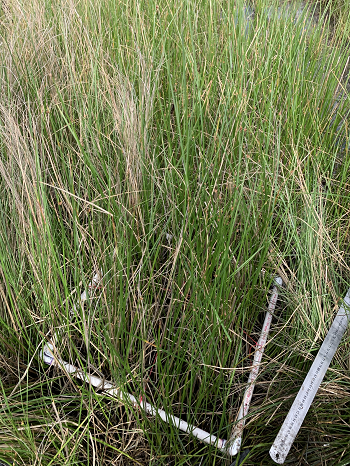
Figure 1. Sampling of aboveground biomass herbaceous vegetation using a 0.25 square meter quadrant.
Citation
Castañeda-Moya, E., and E. Solohin. 2022. Delta-X: Aboveground Biomass and Necromass across Wetlands, MRD, Louisiana, 2021. ORNL DAAC, Oak Ridge, Tennessee, USA. https://doi.org/10.3334/ORNLDAAC/2000
Table of Contents
- Dataset Overview
- Data Characteristics
- Application and Derivation
- Quality Assessment
- Data Acquisition, Materials, and Methods
- Data Access
- References
- Dataset Revisions
Dataset Overview
This dataset contains total carbon, total nitrogen, and total phosphorus content of aboveground biomass (AGB) and necromass (AGN) samples collected from herbaceous wetlands in the Atchafalaya and Terrebonne basins in southeastern coastal Louisiana in 2021. Field measurements were conducted at three sites in the Atchafalaya basin and three sites in the Terrebonne basin. Five of the sites are adjacent to sites from the Coastwide Reference Monitoring System (CRMS). The other site is in the Wax Lake Delta (WLD) without appropriate adjacent CRMS sites. All AGB and AGN plant material within each plot was clipped at soil level, stored in plastic bags, and transported to the laboratory for further analyses. Herbaceous wetland sites in both basins were chosen to represent a salinity gradient including freshwater, brackish, and saline ecosystems. Samples collected were for the Delta-X campaign conducted from 2021-03-19 to 2021-04-02 (spring) and 2021-08-19 to 2021-08-27 (fall).
Project: Delta-X
The Delta-X mission is a 5-year NASA Earth Venture Suborbital-3 mission to study the Mississippi River Delta in the United States, which is growing and sinking in different areas. River deltas and their wetlands are drowning as a result of sea level rise and reduced sediment inputs. The Delta-X mission will determine which parts will survive and continue to grow, and which parts will be lost. Delta-X begins with airborne and in-situ data acquisition and carries through data analysis, model integration, and validation to predict the extent and spatial patterns of future deltaic land loss or gain.
Related Dataset
Castañeda-Moya, E., and E. Solohin. 2022. Delta-X: Belowground Biomass and Necromass across Wetlands in the MRD, LA, USA, 2021. ORNL DAAC, Oak Ridge, Tennessee, USA. https://doi.org/10.3334/ORNLDAAC/1999
Acknowledgments
This work was supported by NASA Earth Venture Suborbital-3 Program (EVS-3; grant NNH17ZDA001N-EVS3).
Data Characteristics
Spatial Coverage: Atchafalaya and Terrebonne Basins and the Wax Lake Delta (WLD), Louisiana, U.S.
Spatial Resolution: Points. Samples were collected from plots (0.25 m-2) located 5 m apart.
Temporal Coverage: 2021-03-21 to 2021-08-27
Temporal Resolution: One-time estimate
Study Area: Latitude and longitude are given in decimal degrees.
| Site | Westernmost Longitude | Easternmost Longitude | Northernmost Latitude | Southernmost Latitude |
|---|---|---|---|---|
| Atchafalaya and Terrebonne Basins | -91.8852 | -90.8219 | 29.5102 | 29.1714 |
Data File Information
There are two data files in comma-separated value (*.csv) format included in this dataset: DeltaX_Aboveground_Biomass_Necromass_Spring2021.csv and DeltaX_Aboveground_Biomass_Necromass_Fall2021.csv.
Data File Details
Data not collected, analyzed, or recorded are represented by -9999 for numeric data and NA for text data.
Table 1. Variable names and descriptions
| Variable | Units | Description |
|---|---|---|
| basin | “Atchafalaya” or “Terrebonne” | |
| campaign | Spring 2021 and Fall 2021 | |
| date_collected | YYYY-MM-DD | Date collected |
| latitude | decimal degrees | Location (latitude) of sampling site |
| longitude | decimal degrees | Location (longitude) of sampling site |
| site_id | Site name | |
| hydrogeomorphic_zone | Supratidal and Intertidal | |
| sampling_station | Sampling station | |
| quadrat_id | Quadrat replicate | |
| species | Vegetation identified by species | |
| vegetation_class | Aboveground biomass (AGB) or necromass (AGN) | |
| total_dry_mass | g m-2 | Total dry mass of aboveground biomass (AGB) and necromass (AGN) plant material per unit area |
| total_carbon | mg g-1 | Total carbon content per unit dried mass of plant material (aboveground biomass (AGB) only) |
| total_nitrogen | mg g-1 | Total nitrogen content per unit dried mass of plant material (aboveground biomass (AGB) only) |
| total_phosphorus | mg g-1 | Total phosphorus content per unit dried mass of plant material (aboveground biomass (AGB) only) |
Application and Derivation
Aboveground vegetation data will be used to calibrate and validate airborne hyperspectral imagery (AVIRIS-NG) to generate landscape-level vegetation mapping and patterns. Data will also be used to generate in situ estimates of AGB, AGN, and species dominance and changes with seasonality in response to environmental conditions across both basins. Moreover, aboveground vegetation data will be used to calibrate and validate the ecogeomorphic (NUMAR) and hydrodynamic models. This research will contribute to a better understanding of how vegetation dynamics and zonation are likely to be influenced by changing ecosystems across deltaic basins. Additionally, the results of this study will be used to generate landscape-level vegetation mapping and patterns to identify indicators of ecosystem vulnerability across multiple coastal basins and environmental settings.
Quality Assessment
For vegetation estimates, four replicate plots (A and B for two stations; area=0.25 m2) were collected at each hydrogeomorphic zone at all sites and used to compute an average. Carbon and nutrient analyses were performed using duplicate analytical replicates of each sample and the run precision was determined based on the relative percent difference between replicates at an acceptance limit of <5%. Accuracy and quality control were determined by the analysis of certified standard reference material during each run. The acceptable limits for accuracy were ±5%. Data outside these limits was not used and samples were re-run to obtain new accurate values.
Data Acquisition, Materials, and Methods
The Spring and Fall 2021 field campaigns were conducted across the Atchafalaya and Terrebonne basins. These data were collected to assess above-ground vegetation dynamics in response to seasonality, soil properties, and river discharge regimes (i.e., low vs. high) across different hydrogeomorphic (HGM) zones.
The campaigns were conducted during the periods 2021-03-19 to 2021-04-02 (spring) and 2021-08-19 to 2021-08-27 (fall). The spring period corresponds to the early phase of the vegetation growing season and the peak of the spring river flood season, while August is considered the period of peak biomass and a period of low river discharge.
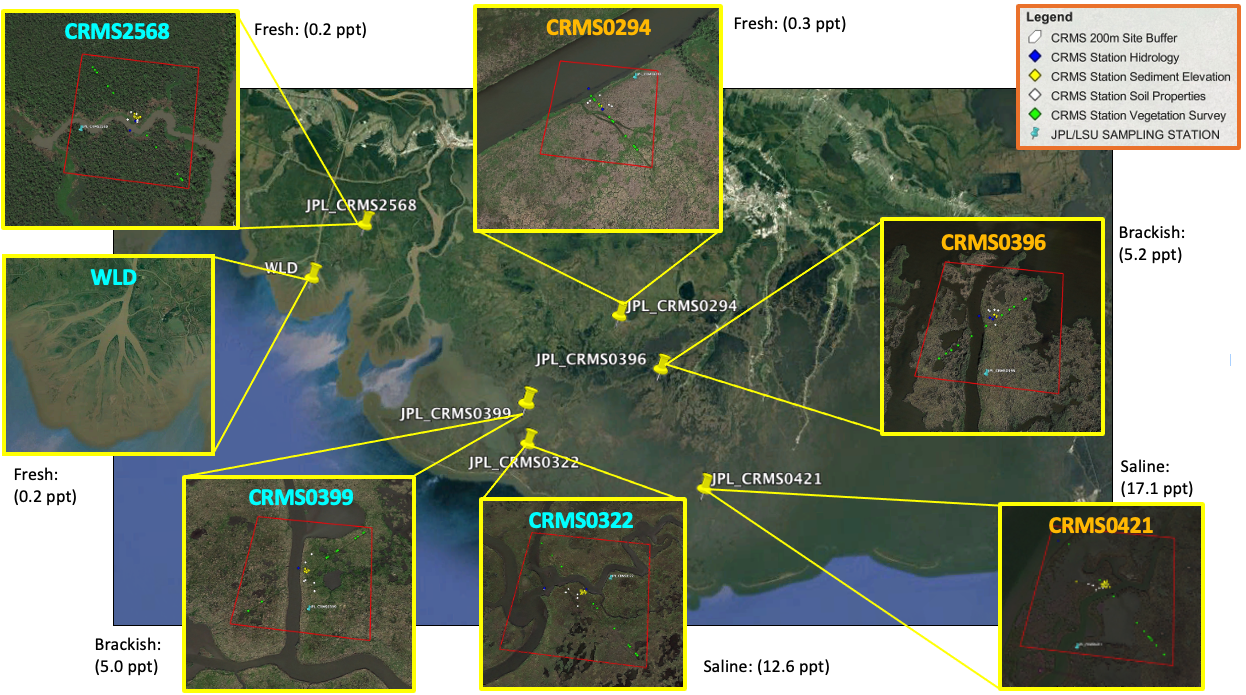
Figure 2. Study area location map.
At each herbaceous wetland site, a transect was established perpendicular to the wetland edge to capture a range of hydrogeomorphic zones (supratidal and intertidal). In each hydrogeomorphic zone (HGM), two sampling stations were established 30 m apart (parallel to the wetland edge). For the herbaceous wetland sites, vegetation structure was measured and aboveground biomass (AGB) and necromass (AGN) were harvested inside duplicate plots (0.25 m-2), located 5 m apart at each sampling station. All AGB and AGN plant material within each plot was clipped at soil level, stored in plastic bags, and transported to the laboratory for further analyses.

Figure 3. Researchers at one of the study areas in coastal Louisiana, U.S.
In the lab, the aboveground plant material collected at all plots was initially sorted by species using standard field protocols and subsequently oven-dried at 60ºC to a constant mass and weighed using a standard laboratory semi-analytical balance (0.01 g precision) (Thomas et al., 2019). Subsamples of aboveground (AGB only) material were ground with a Wiley Mill to pass through a 40 µm mesh screen and stored separately in glass scintillation vials. Total carbon (TC) and total nitrogen (TN) concentrations of plant tissue were determined for each sample with a NA1500 elemental analyzer (Fisons, Instruments, Inc., Danvers, MA). Total P (TP) was extracted using an acid-digested (HCl) extraction and concentrations were determined by colorimetric analysis (EPA Methods 365.4 and 365.2; EPA 1983). Carbon and nutrient content are expressed in mg g-1.
Data Access
These data are available through the Oak Ridge National Laboratory (ORNL) Distributed Active Archive Center (DAAC).
Delta-X: Aboveground Biomass and Necromass across Wetlands, MRD, Louisiana, 2021
Contact for Data Center Access Information:
- E-mail: uso@daac.ornl.gov
- Telephone: +1 (865) 241-3952
References
EPA. 1983. Method 365.4: Total phosphorus (Colorimetric, automated, block digester AA II): U.S. Environmental Protection Agency Washington, DC.
Steyer, G.D., C.E. Sasser, J.M. Visser, E.M. Swenson, J.A. Nyman, and R.C. Raynie. 2003. A proposed coast-wide reference monitoring system for evaluating wetland restoration trajectories in Louisiana. Coastal Monitoring through Partnerships (pp. 107–117). Dordrecht: Springer. https://doi.org/10.1023/A:1021368722681
Thomas, N., M. Simard, E. Castañeda-Moya, K. Byrd, L. Windham-Myers, A. Bevington, and R.R. Twilley. 2019. High-resolution mapping of biomass and distribution of marsh and forested wetlands in southeastern coastal Louisiana. International Journal of Applied Earth Observations and Geoinformation 80:257–267. https://doi.org/10.1016/j.jag.2019.03.013
Dataset Revisions
| Version | Release Date | Description |
|---|---|---|
| 1.2 | 2022-06-03 | This release was updated to replace abbreviations for vegetation species names in the species attribute with complete full vegetation species names. |
| 1.1 | 2022-05-11 | This release provides data from samples collected during the Delta-X Fall Campaign for the period August 19–August 27 as well as the spring data from Version 1.0. |
| 1.0 | 2022-04-17 | This release provided data for the Delta-X Spring Campaign conducted during the period of March 19 to April 2, 2021. |