Documentation Revision Date: 2023-07-06
Dataset Version: 1
Summary
There are 3,816 files in netCDF file format.
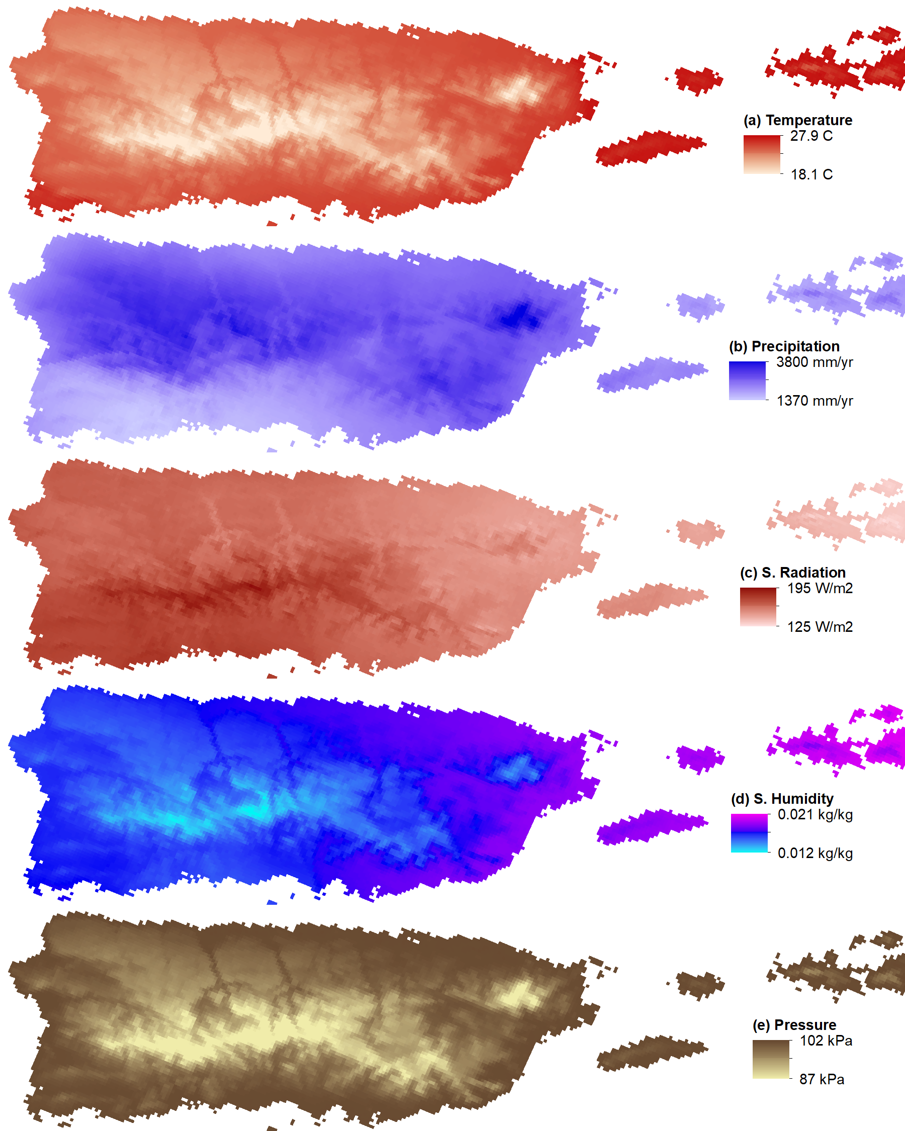
Figure 1. Images of annual climatologies derived from sub-daily variables of a) surface temperature, b) precipitation, c) shortwave radiation, d) specific humidity and e) surface pressure for Puerto Rico and surrounding islands.
Citation
Kao, S-C., M.M. Thornton, P.E. Thornton, R. Shrestha, and A.P. Walker. 2022. Sub-daily Climate Forcings for Puerto Rico. ORNL DAAC, Oak Ridge, Tennessee, USA. https://doi.org/10.3334/ORNLDAAC/1977
Table of Contents
- Dataset Overview
- Data Characteristics
- Application and Derivation
- Quality Assessment
- Data Acquisition, Materials, and Methods
- Data Access
- References
Dataset Overview
To support high spatial- and temporal-resolution land surface modeling, this dataset provides 3-hourly time step historic weather forcing at 1-km spatial resolution for Puerto Rico and surrounding islands. The latest DaymetV4 data (Thornton et al., 2021) provides gridded historic daily weather observation at 1-km spatial resolution from 1950 to present. Using sub-daily temporal information from two meteorological reanalysis datasets (Global Soil Wetness Project Version 3 [GSWP3, Yoshimura and Kanamitsu 2013] and North American Regional Reanalysis [NARR, Mesinger et al. 2006]), Daymet was further temporally downscaled to 3-hourly time steps and provided in the format required for land surface model simulations. The process of temporal downscaling preserves the relative magnitude in each sub-daily time step from GSWP3 and NARR while maintaining the total and average values from Daymet at each day. These result in two blended datasets: 1950–2014 Daymet-GSWP3 and 1979–2019 Daymet-NARR. Available variables include surface air temperature, precipitation, specific humidity, shortwave and longwave radiation, wind speed, and pressure. Among the variables, air temperature, precipitation, specific humidity, and shortwave radiation are the blended information using Daymet, GSWP3, and NARR. Wind speed is the spatially interpolated values from GSWP3 and NARR, and pressure is derived by adjusting GSWP3 and NARR sea level pressure to the Daymet grid elevation. The final datasets are in local time (same as Daymet). These data can be used as a high-resolution meteorological forcing dataset to support high-resolution land surface modeling where accurate meteorological forcing datasets built from historic observations and/or reanalysis datasets are desirable.
Project: Daymet
Daymet provides continuous, gridded estimates of daily weather and climatology variables by interpolating and extrapolating ground-based observations through statistical modeling techniques. The Daymet data products provide driver data for biogeochemical terrestrial modeling and have myriad applications in many Earth science, natural resource, biodiversity, and agricultural research areas. Daymet weather variables include daily minimum and maximum temperature, precipitation, vapor pressure, shortwave radiation, snow water equivalent, and day length produced on a 1 km x 1 km gridded surface over continental North America and Hawaii from 1980 and over Puerto Rico from 1950 through the end of the most recent full calendar year.
Daymet is a research product of the Environmental Sciences Division at Oak Ridge National Laboratory, Oak Ridge, TN. Daymet is supported by NASA through the Earth Science Data and Information System (ESDIS) and the Terrestrial Ecology Program. Daymet algorithm and processing development is also supported by the Office of Biological and Environmental Research within the U.S. Department of Energy's Office of Science.
Related Publication
Thornton, P. E., R. Shrestha, M. M. Thornton, S.-C. Kao, Y. Wei, and B. E. Wilson. 2021. Gridded daily weather data for North America with comprehensive uncertainty quantification: Daymet Version 4. Scientific Data 8:190. https://doi.org/10.1038/s41597-021-00973-0
Related Datasets
Thornton, M.M., R. Shrestha, Y. Wei, P.E. Thornton, S. Kao, and B.E. Wilson. 2020. Daymet: Daily Surface Weather Data on a 1-km Grid for North America, Version 4. ORNL DAAC, Oak Ridge, Tennessee, USA. https://doi.org/10.3334/ORNLDAAC/1840
Acknowledgments
The continued development of the Daymet algorithm and processing is supported in part by the Energy Exascale Earth System Model (E3SM) project, funded by the U.S. Department of Energy, Office of Science, Office of Biological and Environmental Research.
Daymet is supported by NASA through the Earth Science Data and Information System (ESDIS) and the Terrestrial Ecology Program.
Puerto Rico data for Daymet V4 is available for an extended temporal period starting in 1950. Support was provided by the DOE NGEE Tropics Phase 2 funding to extend the temporal period.
Data Characteristics
Spatial Coverage: Puerto Rico
Spatial Resolution: 1 km
Temporal Coverage: 1950-01-1 to 2014-12-31
Temporal Resolution: sub-daily, 3-hourly
Time Zone: Puerto Rico local time (UTC-4)
Data File Information: netCDF
Site Boundaries: Latitude and longitude are given in decimal degrees.
| Site | Westernmost Longitude | Easternmost Longitude | Northernmost Latitude | Southernmost Latitude |
|---|---|---|---|---|
| Puerto Rico and surrounding islands | -67.9927 | -64.1196 | 19.9382 | 16.8444 |
Data File Information
There are 3,816 files in netCDF file format (*.nc).
The file naming convention is clmforce.Daymet4_<reanalysis_ds>_PR.1km.<var>.<yyyy-mm>.nc, where
- <reanalysis_ds> = the meteorological reanalysis dataset 'GSWP3' or 'NARR'
- <var> = the file variable(s) desription abbreviation ('Prec', 'Solr', 'TPQWL')
- <yyyy-mm> = the year-month date range of the file
Example filename: clmforc.Daymet4_GSWP3_PR.1km.Prec.1950-01.nc
Table 1. Variable descriptions per file type for the temporal downscaling of Daymet with GSWP3 and NARR reanalysis datasets.
| Dataset groups | Variable | Description | unit |
|---|---|---|---|
| Daymet4_GSWP3_PR.1km.Prec, Daymet4_NARR_PR.1km.Prec |
PRECTmms | total precipitation | mm s-1 |
| Daymet4_GSWP3_PR.1km.Solr, Daymet4_GSWP3_PR.1km.Solr |
FSDS | total incident solar radiation | W m-2 |
| Daymet4_GSWP3_PR.1km.TPQWL, Daymet4_NARR_PR.1km.TPQWL |
TBOT QBOT PSRF FLDS WIND* |
temperature at the lowest atm level specific humidity at the lowest atm level surface pressure at the lowest atm level incident longwave radiation wind at the lowest atm level |
K kg kg-1 Pa W m-2 m s-1 |
*Wind speed is a GSWP3 and NARR interpolation only
Application and Derivation
These data can be used as a high-resolution meteorological forcing dataset to support high-resolution land surface modeling where accurate meteorological forcing datasets built from historic observations and/or reanalysis datasets are desirable.
Quality Assessment
The quality of this forcing dataset was independently evaluated by 21 hourly rain gauges from the DSI-3240 hourly precipitation dataset (NCEI, 2023) across the island. As shown in the comparison (Figure 2), the coefficients of determination (R2) are largely improved from the raw and interpolated GSWP3 and NARR values across all time scales. This enhancement is important for applications that require more accurate precipitation values. Further studies will be conducted to identify methods to enhance the accuracy of this high-resolution forcing dataset.
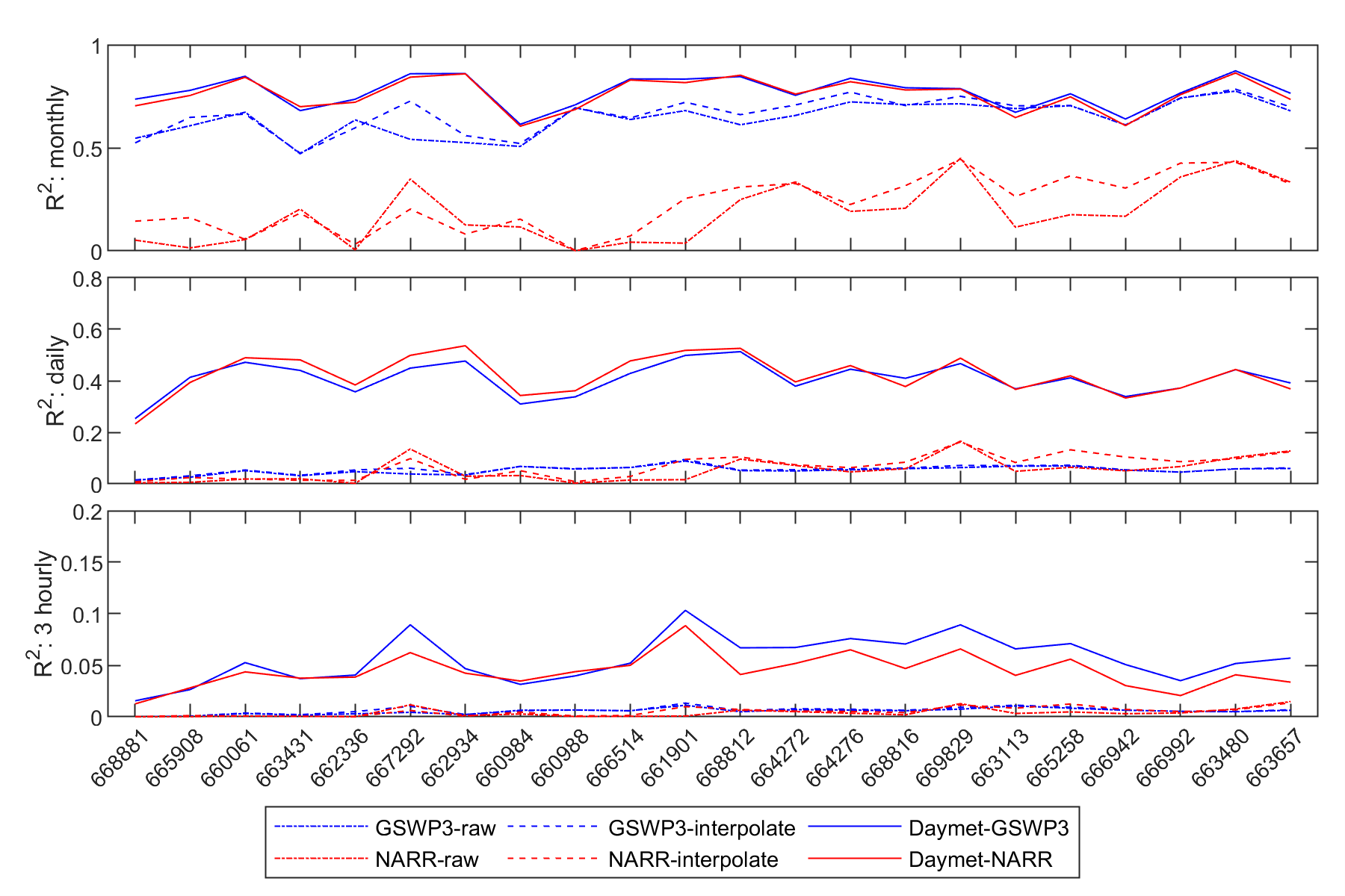
Figure 2. Evaluation of hourly rain gauges to the interpolated GSWP3 and NARR values.
Data Acquisition, Materials, and Methods
During the data blending process, Daymet data were used to spatially downscale GSWP3 and NARR data to match Daymet's fine spatial resolution. The final forcing datasets are available from 1950–2014 for Daymet-GSWP3 and from 1979–2019 for Daymet-NARR. Available variables include surface air temperature, precipitation, specific humidity, shortwave and longwave radiation, wind speed, and pressure. Among the variables, air temperature, precipitation, specific humidity, and shortwave radiation are the blended information using Daymet, GSWP3, and NARR. Wind speed is the spatially interpolated values from GSWP3 and NARR, and pressure is derived by adjusting GSWP3 and NARR sea level pressure to the Daymet grid elevation.
Data Access
These data are available through the Oak Ridge National Laboratory (ORNL) Distributed Active Archive Center (DAAC).
Sub-daily Climate Forcings for Puerto Rico
Contact for Data Center Access Information:
- E-mail: uso@daac.ornl.gov
- Telephone: +1 (865) 241-3952
References
Mesinger, F., G. DiMegoand, E. Kalnay, K. Mitchell, P. C. Shafran, W. Ebisuzaki, D. Jovic, J. Woollen, E. Rogers, E. H. Berbery, M. B. Ek, Y. Fan, R. Grumbine, W. Higgins, H. Li, Y. Lin, G. Manikin, D. Parrish, and W. Shi. 2006. North American Regional Reanalysis. Bulletin of the American Meteorological Society 87:343–360. https://doi.org/10.1175/BAMS-87-3-343
NCEI. 2023. DSI-3240 U.S. Hourly Precipitation Data. National Climatic Data Center, NESDIS, NOAA, U.S. Department of Commerce. https://www.ncei.noaa.gov/metadata/geoportal/rest/metadata/item/gov.noaa.ncdc:C00313/html#
Thornton, P. E., R. Shrestha, M. M. Thornton, S.-C. Kao, Y. Wei, and B. E. Wilson. 2021. Gridded daily weather data for North America with comprehensive uncertainty quantification: Daymet Version 4. Scientific Data 8:190. https://doi.org/10.1038/s41597-021-00973-0
Yoshimura, K., and M. Kanamitsu. 2013. Incremental correction for the dynamical downscaling of ensemble mean atmospheric fields, Monthly Weather Review 141:3087–3101. https://doi.org/10.1175/MWR-D-12-00271.1