Documentation Revision Date: 2024-06-14
Dataset Version: 1
Summary
The NASA AVIRIS-Classic is a pushbroom spectral mapping system with high signal-to-noise ratio (SNR), designed and toleranced for high performance spectroscopy. AVIRIS-Classic measures reflected radiance in 224 contiguous bands at approximately 10-nm intervals in the Visible to Shortwave Infrared (VSWIR) spectral range from 400-2500 nm. The AVIRIS-Classic sensor has a 1 milliradian instantaneous field of view, providing altitude dependent ground sampling distances from 20 m to sub meter range. AVIRIS-Classic supports NASA Science and applications in many areas including plant composition and function, geology and soils, greenhouse gas mapping, and calibration of orbital platforms. In the COMEX project, data from AVIRIS-Classic were combined with ground-based in situ measurements to study techniques for mapping methane plumes using airborne and satellite sensors.
The COMEX-related flights by AVIRIS-Classic occurred on 2014-06-04, 2014-06-12, 2014-06-13, 2014-08-26, and 2014-08-29.
There are 3 files associated with this dataset. One file holds information for COMEX-related flights that has been subsetted from the AVIRIS Facility Instrument collection archived at the ORNL DAAC including basic metadata for each flight line, such as date, site name, and comments about atmospheric conditions. A separate file lists the L1B and L2 data files for each flight available for download through the ORNL DAAC and NASA's Earthdata Search. Download links and Common Metadata Repository (CMR) query text are provided for these files. For convenience, a map of flight line footprints in Keyhole Markup Language (KML) is also included. These tabular data are provided in comma separated values (CSV) format.
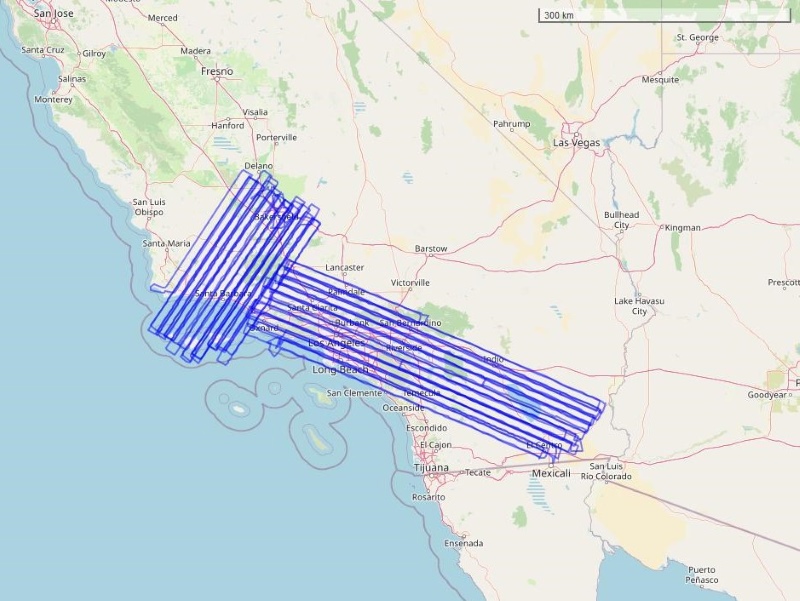
Figure 1. Footprints of COMEX-related flight lines for the AVIRIS-Classic instrument shown as blue rectangles. Area depicted is southern California, U.S.
Citation
Green, R.O., D.K. Thompson, J.W. Boardman, J.W. Chapman, M. Eastwood, M. Helmlinger, S.R. Lundeen, and W. Olson-Duvall. 2024. COMEX: AVIRIS-Classic Facility Instrument Associated Flights and Information, 2014. ORNL DAAC, Oak Ridge, Tennessee, USA. https://doi.org/10.3334/ORNLDAAC/2343
Table of Contents
- Dataset Overview
- Data Characteristics
- Application and Derivation
- Quality Assessment
- Data Acquisition, Materials, and Methods
- Data Access
- References
Dataset Overview
This dataset lists flight lines and provides data access links and contextual flight information for a subset of the Airborne Visible / Infrared Imaging Spectrometer (AVIRIS) also known as the AVIRIS-Classic Facility Instrument Collection that are associated with the CO2 and MEthane eXperiment (COMEX) Project. The COMEX Project was carried out May through September in 2014. AVIRIS-Classic Facility Instrument data are otherwise not replicated in this dataset. The COMEX Project utilized several measurement capabilities including the AVIRIS-Classic airborne facility instrument data to demonstrate that methane emissions associated with fossil fuel production activities in the Los Angeles, California area were of sufficient magnitude and size for space-based observations. These lists of the associated COMEX flights from the AVIRIS-Classic Facility Instrument provide flight lines and access information for the Level 1B Calibrated Radiance data and the Level 2 Calibrated Reflectance data.
This dataset holds information for COMEX-related flights that has been subsetted from the AVIRIS Facility Instrument collection archived at the ORNL DAAC.
Project: COMEX (CO2 and MEthane eXperiment)
The CO2 and MEthane eXperiment (COMEX) campaign, funded bilaterally by NASA and ESA, supported the mission definition of CarbonSat and HyspIRI by providing representative airborne remote sensing data as well as ground-based and airborne in situ data. The objectives were addressed by a unique combination of VIS/NIR/SWIR hyperspectral remote sensing airborne instrumentation (AVIRIS-C, AVIRIS-NG), TIR hyperspectral remote sensing airborne instrumentation (Mako), NIR/SWIR spectroscopic remote sensing airborne instrumentation (MAMAP) as well as in situ airborne (Picarro GHG sensor/analyzer and CIRPAS atmospheric measurements suite) and ground based (AMOG - AutoMObile greenhouse Gas surveyor) measurements for validation and interpretation support. COMEX demonstrated that methane emissions associated with fossil fuel production activities in the Los Angeles area were of sufficient magnitude and size for space-based observations. COMEX was executed between May and September 2014 around the Southern California, USA, area.
Related Publications
Gerilowski, K., S. Krautwurst, D.R. Thompson, A.K. Thorpe, R.W. Kolyer, H. Jonsson, T. Krings, C. Frankenberg, M. Horstjann, I. Leifer, M. Eastwood, R.O. Green, S. Vigil, M. Fladeland, D. Schüttemeyer, J.P. Burrows, and H. Bovensmann. 2016. Passive remote sensing of large-scale methane emissions from Oil Fields in California's San Joaquin Valley and validation by airborne in-situ measurements - Results from COMEX. EGU General Assembly 2016, 17-22 April 2016 in Vienna Austria. ID EPSC2016-15799. https://meetingorganizer.copernicus.org/EGU2016/EGU2016-15799-1.pdf
Krautwurst, S., K. Gerilowski, T. Krings, J. Borchard, and H. Bovensmann. 2016. COMEX - Final Report. University of Bremen; Germany. https://earth.esa.int/eogateway/documents/20142/37627/COMEX-Final-Report.pdf
Thompson, D.R., I. Leifer, H. Bovensmann, M. Eastwood, M. Fladeland, C. Frankenberg, K. Gerilowski, R.O. Green, S. Kratwurst, T. Krings, B. Luna, and A.K. Thorpe. 2015. Real-time remote detection and measurement for airborne imaging spectroscopy: a case study with methane. Atmospheric Measurement Techniques 8:4383–4397. https://doi.org/10.5194/amt-8-4383-2015
Tratt, D.M., K.N. Buckland, J.L. Hall, P.D. Johnson, E.R. Keim, I. Leifer, K. Westberg, and S.J. Young. 2014. Airborne visualization and quantification of discrete methane sources in the environment. Remote Sensing of Environment 154:74-88. https://doi.org/10.1016/j.rse.2014.08.011
Related Datasets
Green, R.O., P.G. Brodrick, J.W. Chapman, M. Eastwood, S. Geier, M. Helmlinger, S.R. Lundeen, W. Olson-Duvall, R. Pavlick, L.M. Rios, D.R. Thompson, and A.K. Thorpe. 2023a. AVIRIS Facility Instruments: Flight Line Geospatial and Contextual Data. ORNL DAAC, Oak Ridge, Tennessee, USA. https://doi.org/10.3334/ORNLDAAC/2140
Green, R.O., D.R. Thompson, J.W. Boardman, J.W. Chapman, M. Eastwood, M. Helmlinger, S.R. Lundeen, and W. Olson-Duvall. 2023b. AVIRIS-Classic: L1B Calibrated Radiance, Facility Instrument Collection, V1. ORNL DAAC, Oak Ridge, Tennessee, USA. https://doi.org/10.3334/ORNLDAAC/2155
Green, R.O., D.R. Thompson, J.W. Boardman, J.W. Chapman, M. Eastwood, M. Helmlinger, S.R. Lundeen, and W. Olson-Duvall. 2023c. AVIRIS-Classic: L2 Surface Reflectance, Facility Instrument Collection, V1. ORNL DAAC, Oak Ridge, Tennessee, USA. https://doi.org/10.3334/ORNLDAAC/2154
- These three collections provide information about additional AVIRIS-Classic flights and resulting data products. The tables in the current dataset refer to files in these collections.
Green, R.O., P.G. Brodrick, J.W. Chapman, M. Eastwood, S. Geier, M. Helmlinger, S.R. Lundeen, W. Olson-Duvall, R. Pavlick, L.M. Rios, D.R. Thompson, and A.K. Thorpe. 2024. COMEX: AVIRIS-NG Facility Instrument Associated Flights and Information, 2014. ORNL DAAC, Oak Ridge, Tennessee, USA. https://doi.org/10.3334/ORNLDAAC/2342
- This collection provides information about COMEX-related flights by a similar airborne spectrometer, AVIRIS-Next Generation.
Acknowledgement
The COMEX project received funding support from NASA (grants NNX13AM07G, NNX13AM21G) and from the European Space Agency.
Data Characteristics
Spatial Coverage: Portion of California east of Los Angeles, U.S.
Spatial Resolution: Flight lines of approximately 10 km in length
Temporal Coverage: 2014-06-04 to 2014-08-29
Temporal Resolution: One-time estimates
Study Area: Latitude and longitude are given in decimal degrees.
| Site | Northernmost Latitude | Southernmost Latitude | Easternmost Longitude | Westernmost Longitude |
|---|---|---|---|---|
| California | 35.793 | 32.665 | -120.670 | -114.777 |
Data File Information
This dataset holds two files in comma separated values (.csv) format and one map in compressed Keyhole Markup Language (.kmz).
- COMEX_AVIRIS-Classic_info.csv : A list of AVIRIS-Classic flight lines (scenes) associated with COMEX project (Table 1)
- COMEX_AVIRIS-Classic_files.csv : Level 1B and Level 2 data files available fore each flight line (Table 2).
- COMEX_AVIRIS-Classic.kmz : provides a map of the flight line footprints in compressed Keyhole Markup Language.
The AVIRIS-Classic flight line identifier is formated as f<YYMMDD>t01p00r<aa>, encoding the date and time by year (YY), month (MM), day (DD), and the airborne flight run number (aa) (e.g., f060426t01p00r03) Date-time is in UTC.
Table 1. Variables in COMEX_AVIRIS-Classic_info.csv.
| Variable | Description |
|---|---|
| Sensor | "AVIRIS-Classic" |
| Date | Date of flight in YYYY-MM-DD |
| Flight_line | Flight line (scene) identifier (e.g., "f140604t01p00r06") |
| Flight_scene | Flight line with suffix (e.g., "_sc01") to denote separate scenes (e.g., "f140604t01p00r06_sc01") |
| Site_name | Location name from NASA flight log |
| NASA_Log | NASA flight log ID |
| Investigator | Person/researcher/investigator associated with flight |
| Comments | Notes about flight such as aircraft altitude and haze/cloud cover. |
| KMZ_download | URL for downloading a polygon of imagery footprint from ORNL DAAC in compressed Keyhole Markup Language format. If NA, no KMZ file is available. |
Table 2. Variables in COMEX_AVIRIS-Classic_files.csv.
| Variable | Description |
|---|---|
| Sensor | "AVIRIS-Classic" |
| Product | Data product: "L1B_Radiance" or "L2_Reflectance" |
| Flight_line | Flight line (scene) identifier (e.g., "f140604t01p00r06") |
| Date | Date of flight in YYYY-MM-DD |
| Filename | Name of L1B or L2 file available from ORNL DAAC. |
| File_size_mb | File size in megabytes |
| Checksum_sha256 | SHA-256 checksum value for file. |
| Download_url | URL for downloading file from ORNL DAAC |
| CMR_query | URL for obtaining most up-to-date information about file from NASA Earthdata's Common Metadata Record (CMR) system. Information is returned in JSON format. |
User Notes:
- An active Earthdata login is required for accessing files and CMR information using the provided URLs. Earthdata accounts are available free of charge at https://urs.earthdata.nasa.gov/.
- L1B radiance data files are provided in ENVI format. There are multiple files per flight line, which includes quicklook images (JPEG). See the AVIRIS-Classic L1B Calibrated Radiance, Facility Instrument Collection for more details about these files.
- For L2 surface reflectance data, see the AVIRIS-Classic L2 Surface Reflectance, Facility Instrument Collection for more details about these files.
- Users should cite both this dataset and the corresponding Facility Instrument Collection datasets above when accessing and using the underlying Facility Instrument data in publications, in accordance with the NASA Earthdata Data Use Guidance. See our Data Use and Citation Guidelines for more information.
- Additional information about AVIRIS-Classic flights is available in the AVIRIS Facility Instruments: Flight Line Geospatial and Contextual Data collection.
Application and Derivation
These resources assist researchers in accessing AVIRIS-Classic imagery data associated with the COMEX project.
The objectives of the COMEX campaign activities include:
- Investigate spatial/spectral resolution trade-offs for CH4 anomaly detection and flux inversion by comparison of MAMAP-derived emission estimates with AVIRIS-Classic/AVIRIS-NG derived data.
- Evaluate sun-glint observation geometry on CH4 retrievals for marine sources.
- Characterise the effect of Surface Spectral Reflectance (SSR) heterogeneity on trace gas retrievals of CO2 and CH4 for medium and low-resolution spectrometry.
- Identify benefits from joint SWIR/TIR data for trace gas detection and retrieval by comparison of MAMAP and AVIRIS-Classic/AVIRIS-NG NIR/SWIR data with MAKO TIR data.
Further information about the COMEX project is available from Krautwurst, et al. (2016) and ESA (2024).
Results from COMEX research on methane source mapping are available from Bradley et al. (2011), Thompson et al. (2015), Tratt et al. (2014), and Zhang et al. (2017).
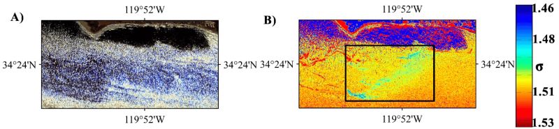
Figure 2. (A) True color imagery of Airborne Visual Infrared Imaging Spectrometer-Classic (AVIRIS-C) data acquired on 19 June 2008 over the Coal Oil Point marine seep field in the Santa Barbara Channel offshore from Goleta, California. (B) Band ratio (σ) of at-sensor reflectance (ρt) for the 2298 and 2058 nm bands, σ = ρt(2298)/ρt(2058) for AVIRIS-C data in (A), black rectangle outline shows clear methane plume structure. Source: Zhang et al. (2017).
Quality Assessment
None conducted.
Data Acquisition, Materials, and Methods
These resources assist researchers in accessing AVIRIS-Classic imagery data associated with the COMEX project. This project was conducted June to September in 2014 in southern California, U.S. (Figure 1). The flights by AVIRIS-Classic occurred on 2014-06-04, 2014-06-12, 2014-06-13, 2014-08-26, and 2014-08-29. The area covered by these flights extends beyond the sites that were the focus of the COMEX project.
The AVIRIS-Classic is a pushbroom spectral mapping system with high signal-to-noise ratio (SNR), designed and toleranced for high performance spectroscopy. AVIRIS-Classic measures reflected radiance in 224 contiguous bands at approximately 10-nm intervals in the Visible to Shortwave Infrared (VSWIR) spectral range from 400-2500 nm. The AVIRIS-Classic sensor has a 1 milliradian instantaneous field of view, providing altitude dependent ground sampling distances from 20 m to sub meter range. For COMEX, AVIRIS-Classic was flown on the NASA ER-2 aircraft.
A list of COMEX-related flights was compared to data available in the ORNL DAAC's AVIRIS Project collections. Flight information was compiled from Green et al. (2023a). The original sources of this information includes NASA flight logs and metadata provided by the AVIRIS team at NASA's Jet Propulsion Laboratory (see https://aviris.jpl.nasa.gov/).
A list of data files from the L1B (Green et al., 2023b) and L2 (Green et al., 2023c) was developed.
Further information about L1B and L2 files
For L1B radiance, there are multiple file types for each flight line: orthocorrected calibrated radiance image (img) files, geometric lookup table (glt) and orthocorrected observation geometry and illumination (obs_ort) files. Also included are unprojected files of input geometry (igm), and parameters relating to the geometry of observation and illumination (obs). Additional files provide information on spectral (spc) and radiometric calibration (rcc, gain), spatial resolution (geo), aircraft and sensor position (eph, nav), deployment notes (info), and data processing (plog). Quicklook images (jpeg) and polygon outlines of imagery footprints (kmz) are provided for each flight line. The AVIRIS-Classic L1B data are provided in ENVI binary format, which includes a flat binary file accompanied by a header (.hdr) file holding metadata in text format. The ancillary files include JPEG images, maps in Keyhole Markup Language (KML), and calibration files in binary and text formats.
For L2 surface reflectance, two types of data files may be included: (a) calibrated surface reflectance and (b) water vapor and optical absorption paths for liquid water and ice. The L2 data are also provided in ENVI format.
Data Access
These data are available through the Oak Ridge National Laboratory (ORNL) Distributed Active Archive Center (DAAC).
COMEX: AVIRIS-Classic Facility Instrument Associated Flights and Information, 2014
Contact for Data Center Access Information:
- E-mail: uso@daac.ornl.gov
- Telephone: +1 (865) 241-3952
References
Bradley, E.S., I. Leifer, D.A. Roberts, P.E. Dennison, and L. Washburn. 2011. Detection of marine methane emissions with AVIRIS band ratios. Geophysical Research Letters 38:L10702. https://doi.org/10.1029/2011GL046729
ESA. 2024. COMEX: Scientific and technical assistance for the deployment of a flexible airborne spectrometer system during C-MAPExp and COMEX. European Space Agency. https://doi.org/10.5270/esa-k85rkdq
Gerilowski, K., S. Krautwurst, D.R. Thompson, A.K. Thorpe, R.W. Kolyer, H. Jonsson, T. Krings, C. Frankenberg, M. Horstjann, I. Leifer, M. Eastwood, R.O. Green, S. Vigil, M. Fladeland, D. Schüttemeyer, J.P. Burrows, and H. Bovensmann. 2016. Passive remote sensing of large-scale methane emissions from Oil Fields in California's San Joaquin Valley and validation by airborne in-situ measurements - Results from COMEX. EGU General Assembly 2016, 17-22 April 2016 in Vienna Austria. ID EPSC2016-15799. https://meetingorganizer.copernicus.org/EGU2016/EGU2016-15799-1.pdf
Green, R.O., P.G. Brodrick, J.W. Chapman, M. Eastwood, S. Geier, M. Helmlinger, S.R. Lundeen, W. Olson-Duvall, R. Pavlick, L.M. Rios, D.R. Thompson, and A.K. Thorpe. 2023a. AVIRIS Facility Instruments: Flight Line Geospatial and Contextual Data. ORNL DAAC, Oak Ridge, Tennessee, USA. https://doi.org/10.3334/ORNLDAAC/2140
Green, R.O., D.R. Thompson, J.W. Boardman, J.W. Chapman, M. Eastwood, M. Helmlinger, S.R. Lundeen, and W. Olson-Duvall. 2023b. AVIRIS-Classic: L1B Calibrated Radiance, Facility Instrument Collection, V1. ORNL DAAC, Oak Ridge, Tennessee, USA. https://doi.org/10.3334/ORNLDAAC/2155
Green, R.O., D.R. Thompson, J.W. Boardman, J.W. Chapman, M. Eastwood, M. Helmlinger, S.R. Lundeen, and W. Olson-Duvall. 2023c. AVIRIS-Classic: L2 Surface Reflectance, Facility Instrument Collection, V1. ORNL DAAC, Oak Ridge, Tennessee, USA. https://doi.org/10.3334/ORNLDAAC/2154
Krautwurst, S., K. Gerilowski, T. Krings, J. Borchard, and H. Bovensmann. 2016. COMEX - Final Report. University of Bremen; Germany. https://earth.esa.int/eogateway/documents/20142/37627/COMEX-Final-Report.pdf
Green, R.O., P.G. Brodrick, J.W. Chapman, M. Eastwood, S. Geier, M. Helmlinger, S.R. Lundeen, W. Olson-Duvall, R. Pavlick, L.M. Rios, D.R. Thompson, and A.K. Thorpe. 2024. COMEX: AVIRIS-NG Facility Instrument Associated Flights and Information, 2014. ORNL DAAC, Oak Ridge, Tennessee, USA. https://doi.org/10.3334/ORNLDAAC/2342
Thompson, D.R., I. Leifer, H. Bovensmann, M. Eastwood, M. Fladeland, C. Frankenberg, K. Gerilowski, R.O. Green, S. Kratwurst, T. Krings, B. Luna, and A.K. Thorpe. 2015. Real-time remote detection and measurement for airborne imaging spectroscopy: a case study with methane. Atmospheric Measurement Techniques 8:4383–4397. https://doi.org/10.5194/amt-8-4383-2015
Tratt, D.M., K.N. Buckland, J.L. Hall, P.D. Johnson, E.R. Keim, I. Leifer, K. Westberg, and S.J. Young. 2014. Airborne visualization and quantification of discrete methane sources in the environment. Remote Sensing of Environment 154:74–88. https://doi.org/10.1016/j.rse.2014.08.011
Zhang, M., I. Leifer, and C. Hu. 2017. Challenges in methane column retrievals from AVIRIS-NG Imagery over Spectrally Cluttered Surfaces: A Sensitivity Analysis" Remote Sensing 9:835. https://doi.org/10.3390/rs9080835