Documentation Revision Date: 2024-06-14
Dataset Version: 1
Summary
This dataset holds one file in comma separated values (CSV) format. The file lists information for COMEX-related datasets that has been subsetted from AJAX collections archived through NASA's Atmospheric Science Data Center (https://asdc.larc.nasa.gov/project/AJAX).

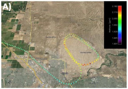
Figure 1. Methane concentrations from the Alpha Jet over Kern River oil field and environs in California on 10 June 2014. Source: Krautwurst et al. (2016).
Citation
Iraci, L., J.M. St.Clair, and T.P. Bui. 2024. COMEX: Flight Information for AJAX Airborne In Situ CO2 and CH4, 2014-2015, USA. ORNL DAAC, Oak Ridge, Tennessee, USA. https://doi.org/10.3334/ORNLDAAC/2347
Table of Contents
- Dataset Overview
- Data Characteristics
- Application and Derivation
- Quality Assessment
- Data Acquisition, Materials, and Methods
- Data Access
- References
Dataset Overview
This dataset provides information to access NASA Earthdata published flight data and flight information collected by the Alpha Jet Atmospheric eXperiment (AJAX) and associated with the COMEX project in 2014-2015. The file lists information for COMEX-related datasets that has been subsetted from AJAX collections archived through NASA's Atmospheric Science Data Center. AJAX data are not otherwise replicated in this dataset. AJAX is a partnership between NASA's Ames Research Center and H211, L.L.C., which conducted in-situ measurements over California, Nevada, and the coastal Pacific in support of satellite validation. During COMEX data collection, a Picarro greenhouse gas (GHG) sensor was mounted on an Alpha Jet, a tactical strike fighter developed by Dassault-Breguet and Dornier through a German-French NATO collaboration. The GHG sensor made repeat measurements in California and Nevada. In situ data included measurements of CO2, CH4, and H2O at 2 Hz or CH4 and H2O at 10 Hz with a strategy of characterizing atmospheric structure over ocean and land, and vertical profiles to at least 5000 m. Ancillary data, including O3, formaldehyde, and meteorological profiles, were also collected. This dataset provides filenames, spatiotemporal bounds, and download URLs for accessing these in situ data. This information is provided in comma separated values (CSV) format.
This dataset holds information for COMEX-related datasets that has been subsetted from AJAX collections archived at NASA's Atmospheric Science Data Center (https://asdc.larc.nasa.gov) (Iraci 2021a, 2021b, 2021c).
Project: COMEX (CO2 and MEthane eXperiment)
The CO2 and MEthane eXperiment (COMEX) campaign, funded bilaterally by NASA and ESA, supported the mission definition of CarbonSat and HyspIRI by providing representative airborne remote sensing data as well as ground-based and airborne in situ data. The objectives were addressed by a unique combination of VIS/NIR/SWIR hyperspectral remote sensing airborne instrumentation (AVIRIS-C, AVIRIS-NG), TIR hyperspectral remote sensing airborne instrumentation (Mako), NIR/SWIR spectroscopic remote sensing airborne instrumentation (MAMAP) as well as in situ airborne (Picarro GHG sensor/analyzer and CIRPAS atmospheric measurements suite) and ground based (AMOG - AutoMObile greenhouse Gas surveyor) measurements for validation and interpretation support. COMEX demonstrated that methane emissions associated with fossil fuel production activities in the Los Angeles area were of sufficient magnitude and size for space-based observations. COMEX was executed between May and September 2014 around the Southern California, USA, area.
Acknowledgement
The COMEX project received funding support from NASA (grants NNX13AM07G, NNX13AM21G) and from the European Space Agency.
Data Characteristics
Spatial Coverage: Portions of southern California, U.S.
Spatial Resolution: Flight lines of varying lengths
Temporal Coverage: 2014-05-19 to 2015-08-19
Temporal Resolution: One-time estimates
Study Area: Latitude and longitude are given in decimal degrees.
| Site | Northernmost Latitude | Southernmost Latitude | Easternmost Longitude | Westernmost Longitude |
|---|---|---|---|---|
| California | 38.894 | 34.130 | -116.259 | -122.057 |
Data File Information
This dataset holds one file in comma separated values (.csv) format: comex_ajax_download_table.csv
This CSV lists data files that are in ICARTT format, which is described in the ICARTT File Format Standards V1.1.
The file naming convention for these ICARTT files is AJAX-<metric>_ALPHA_<date>_<version>_F<flight>.ict, where
- <metric> - indicates primary type of measurements: "CO2CH4" (carbon dioxide and methane), "MMS" (meteorological profiles), "O3" (ozone)
- <date> - date of flight in YYYMMDD format
- <version> - revision number: "R0" or "R1"
- <flight> - three digit flight number for AJAX project
Table 1. Variables in comex_ajax_download_table.csv.
| Variable | Description |
|---|---|
| filename | Name of ICARTT data file. |
| flight _number | three digit flight number for AJAX project |
| category | type of data file: "mission data" or "related data" |
| start_time | starting time of data collection in UTC time (YYYY-MM-DD hh:mm) |
| end_time | ending time of data collection in UTC time (YYYY-MM-DD hh:mm) |
| max_lat | maximum latitude for data in decimal degrees |
| min_lat | minimum latitude for data in decimal degrees |
| max_lon | maximum longitude for data in decimal degrees |
| min_lon | minimum longitude for data in decimal degrees |
| file_type | "table" |
| file_format | "text/icartt" |
| download | URL for downloading the data file |
| file_size_mb | file size in megabytes |
User Note:
- An active Earthdata login is required for accessing files using the provided URLs. Earthdata accounts are available free of charge at https://urs.earthdata.nasa.gov/.
- Users should cite both this dataset and the corresponding AJAX collections (Iraci 2021a, 2021b, and 2021c) archived at NASA's Atmospheric Science Data Center when accessing and using the underlying data in publications, in accordance with the NASA Earthdata Data Use Guidance. See our Data Use and Citation Guidelines for more information.
Application and Derivation
These resources assist researchers in accessing AJAX data associated with the COMEX project.
During COMEX, an Alpha Jet from NASA's Ames Research Center carred a Picarro GHG sensor that was tasked for repeat GHG measurements in California and Nevada. In situ data that were collected including measurements of CO2, CH4, and H2O at 2 Hz or CH4 and H2O at 10 Hz with a strategy of characerizing the larger atmospheric structure over ocean and land, and vertical profiles to at least 5000 m.
Further information about the COMEX project is available from Krautwurst, et al. (2016) and ESA (2024).

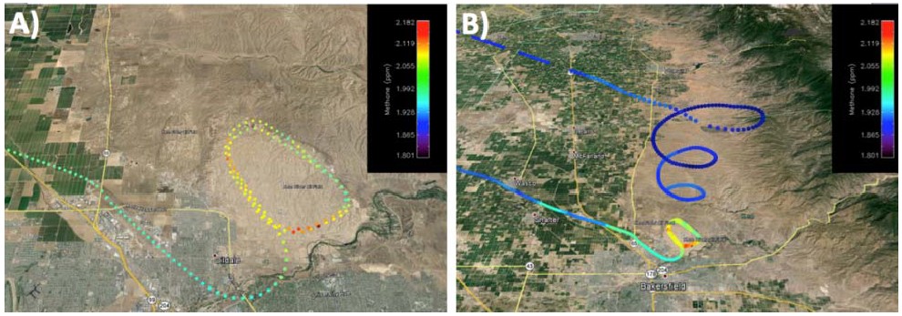
Figure 2. Methane concentrations from the Alpha Jet over Kern River oil field and environs in California on 10 June 2014. (A) Depiction of two-dimensional change in CH4 at low altitudes. (B) Three-dimensional depiction of CH4 concentrations from high to low altitudes. Source: Krautwurst et al. (2016).
Quality Assessment
Descriptive information can be found in Iraci (2021a, 2021b, 2021c) for each relevant chemical species collected.
Data Acquisition, Materials, and Methods
| During COMEX data collection, a Picarro greehouse gas (GHG) sensor was mounted on an Alpha Jet (Hamill et al., 2016) and was tasked for repeat GHG measurements in California and Nevada. These in situ data include measurements of CO2, CH4, and H2O at 2 Hz or CH4 and H2O at 10 Hz with a strategy of characterizing atmospheric structure over ocean and land, and vertical profiles to at least 5000 m. |  |
These Picarro in situ data have been used in estimating the emission rates of ground locations and to scale background atmospheric profiles for the radiative transfer model SCIATRAN used for the Methane Airborne MAPper (MAMAP) retrieval.
This dataset holds information for COMEX-related datasets that have been subsetted from the AJAX collections archived at NASA's Atmospheric Science Data Center (https://asdc.larc.nasa.gov) (Iraci 2021a, 2021b, 2021c).

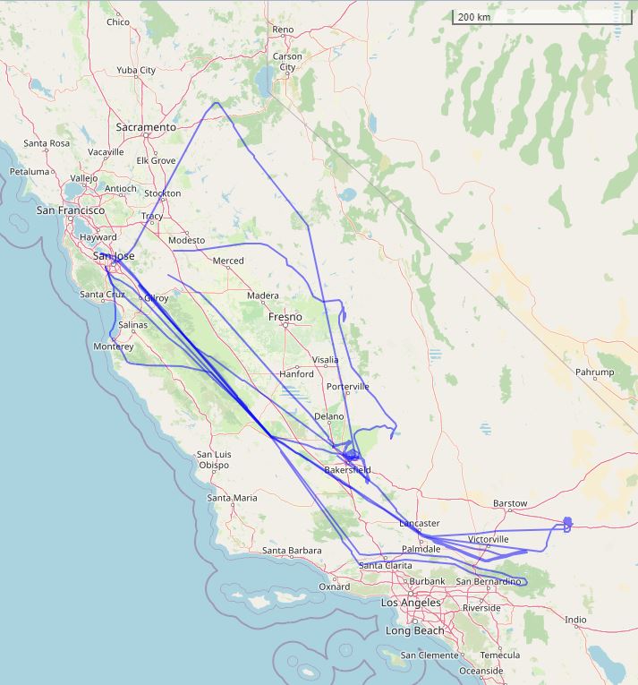
Figure 3. Flight paths of six AJAX flights related to the COMEX project shown as blue lines over southern California, U.S. Flights originated from NASA's Ames Research Center at Moffet Field, near San Jose, California. Basemap: © OpenStreetMap contributors.
Data Access
These data are available through the Oak Ridge National Laboratory (ORNL) Distributed Active Archive Center (DAAC).
COMEX: Flight Information for AJAX Airborne In Situ CO2 and CH4, 2014-2015, USA
Contact for Data Center Access Information:
- E-mail: uso@daac.ornl.gov
- Telephone: +1 (865) 241-3952
References
ESA. 2024. COMEX: Scientific and technical assistance for the deployment of a flexible airborne spectrometer system during C-MAPExp and COMEX. European Space Agency. https://doi.org/10.5270/esa-k85rkdq
Hamill, P., L.T. Iraci, E.L. Yates, W. Gore, T.P. Bui, T. Tanaka, and M. Loewenstein. 2016. A new instrumented airborne platform for atmospheric research. Bulletin of the American Meteorological Society 97:397–404. https://doi.org/10.1175/BAMS-D-14-00241.1
Iraci, L. 2021a. Alpha Jet Atmospheric eXperiment. NASA Langley Atmospheric Science Data Center Distributed Active Archive Center. https://doi.org/10.5067/ASDC/AJAX_CH2O
Iraci, L. 2021b. Alpha Jet Atmospheric eXperiment. NASA Langley Atmospheric Science Data Center Distributed Active Archive Center. https://doi.org/10.5067/ASDC/AJAX_CO2_CH4
Iraci, L. 2021c. Alpha Jet Atmospheric eXperiment. NASA Langley Atmospheric Science Data Center Distributed Active Archive Center. https://doi.org/10.5067/ASDC/AJAX_O3
Krautwurst, S., K. Gerilowski, T. Krings, J. Borchard, and H. Bovensmann. 2016. COMEX - Final Report. University of Bremen; Germany. https://earth.esa.int/eogateway/documents/20142/37627/COMEX-Final-Report.pdf