Documentation Revision Date: 2024-09-17
Dataset Version: 1
Summary
This dataset includes 264 files in LAS (*.las) format and one file in comma separated values (*.csv) format.
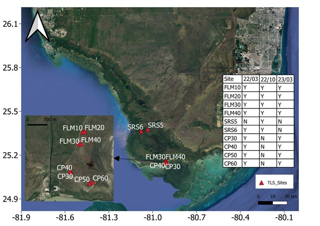
Figure 1. Terrestrial laser scanning (TLS) field sites in Everglades National Park, FL. FLM10, FLM20, FLM30, FLM40, CP30, CP40, CP50, CP60 are field sites in ghost forests. SRS5 and SRS6 are field sites along the Shark River Estuary.
Citation
Xiong, L., D. Lagomasino, and B. Poulter. 2024. Blueflux: Terrestrial Lidar Scans of Mangrove Forests, Everglades, FL, USA, 2022-2023. ORNL DAAC, Oak Ridge, Tennessee, USA. https://doi.org/10.3334/ORNLDAAC/2311
Table of Contents
- Dataset Overview
- Data Characteristics
- Application and Derivation
- Quality Assessment
- Data Acquisition, Materials, and Methods
- Data Access
- References
Dataset Overview
This dataset contains point clouds of three-dimensional (3D) mangrove forest structure and volume collected from 10 sites in Everglades National Park, Florida. Data were collected during NASA CMS “Blueflux” campaigns in March 2022, October 2022, and March 2023 (2022-03-20 to 2023-03-13). Products were acquired using a RIEGL VZ-400i terrestrial laser scanner (TLS). TLS is a non-destructive and quantitative method for in situ 3D forest structure measuring and monitoring.
Project: Carbon Monitoring System (CMS)
The NASA Carbon Monitoring System (CMS) program is designed to make significant contributions in characterizing, quantifying, understanding, and predicting the evolution of global carbon sources and sinks through improved monitoring of carbon stocks and fluxes. The System uses NASA satellite observations and modeling/analysis capabilities to establish the accuracy, quantitative uncertainties, and utility of products for supporting national and international policy, regulatory, and management activities. CMS data products are designed to inform near-term policy development and planning.
Related Publication:
Poulter, B., F. M. Adams-Metayer, C. Amaral, A. Barenblitt, A. Campbell, S. P. Charles, R. M. Roman-Cuesta, R. D’Ascanio, E. R. Delaria, C. Doughty, T. Fatoyinbo, J. Gewirtzman, T. F. Hanisco, M. Hull, S. R. Kawa, R. Hannun, D. Lagomasino, L. Lait, S. L. Malone, P. A. Newman, P. Raymond, J. A. Rosentreter, N. Thomas, D. Vaughn, G. M. Wolfe, L. Xiong, Q. Ying, and Z. Zhang. 2023. Multi-scale observations of mangrove blue carbon ecosystem fluxes: The NASA Carbon Monitoring System BlueFlux field campaign. Environmental Research Letters 18:075009. https://doi.org/10.1088/1748-9326/acdae6
Acknowledgements:
These data were produced as part of the Blue Carbon Prototype Products for Mangrove Methane and Carbon Dioxide Fluxes (BLUEFLUX) project supported by NASA grant 80NSSC21K1564.
Data Characteristics
Spatial Coverage: Everglades National Park, Florida, USA
Spatial Resolution: point clouds with <1 cm spacing
Temporal Coverage: March 2022, October 2022, and March 2023
Temporal Resolution: Periodic measurements over three campaigns
Study Areas: Latitude and longitude are given in decimal degrees.
| Site | Westernmost Longitude | Easternmost Longitude | Northernmost Latitude | Southernmost Latitude |
|---|---|---|---|---|
| Everglades National Park, Florida, USA | -81.08 | -80.91 | 25.38 | 25.14 |
Data File Information
This dataset includes 265 files. There are 264 files containing point cloud data in LAS files (*.las) format and one file in comma separated values (*.csv) format holding metadata about the LAS files.
The LAS files hold point clouds used for measuring three-dimensional (3D) mangrove forest structure and volume.
The coordinate reference system (CRS) for the LAS files is UTM zone 17N (EPSG: 32617).
LAS files are named Site_Day_ScanPos-SINGLESCANS-YYMMDD_TTTTTT.las where:
- Site is the sample site name
- Day indicates whether a measurement was taken on the first or second day of sampling at a given site during a given campaign. ‘Day1’ is not present for sites that only had one day of measurement during a campaign.
- ScanPos indicates the scan position within a given site.
- YYMMDD_TTTTTT is the data and time of the measurement (e.g. 221018_111526 for Oct. 18, 2022 at 11:15:26 am)
Table 1. Data dictionary for TLS_Mangrove_Forests_Everglades_File_Characteristics.csv. Easting and northing coordinates are in UTM zone 17N (EPSG: 32617).
| Variable | Units | Description |
|---|---|---|
| Filename | - | LAS filename |
| File_size_mb | mb | Size of LAS file in mb |
| Date | YYYY-MM-DD | Collection date |
| Number_of_records | 1 | Number of records (points) |
| Min_East | m | UTM easting for easternmost point |
| Max_East | m | UTM easting for westernnmost point |
| Min_North | m | UTM northing for southernnmost point |
| Max_north | m | UTM northing for northernmost point |
Companion File
This dataset has one companion file, TLS_Mangrove_Forests_Everglades_File_Characteristics.pdf, that contains metadata characteristics of each LAS file. Characteristics include: file name, file size, collection date, number of records (points), and the geographic bounding box. These values match those in TLS_Mangrove_Forests_Everglades_File_Characteristics.csv.
Application and Derivation
These 3D measurements from TLS scans provide information on stem density, vertical distributions of biomass, stand volume and surface area. The results can supplement field plot-based forest inventory data and provide surface area estimates for scaling chamber flux measurements (Calders et al., 2020). TLS data can also be used for calibration and validation of airborne and spaceborne lidar such as G-LiHT and GEDI.
Quality Assessment
The laser range accuracy for VZ-400i is 5 mm at 100 m distance. Co-registration accuracy is <2 cm. Georeferencing accuracy is dominated by accuracy of GNSS base stations, which is ~3 cm in ghost forest sites and ~10 cm in healthy forest sites (SRS5 and SRS6).
Data Acquisition, Materials, and Methods
Methods
A RIEGL VZ-400i terrestrial laser scanning (TLS) was used to collect point clouds for measuring forest structure at eight sites dominated by mangrove forest in Everglades National Park in Florida, USA. The sites cover a gradient of 'healthy' mangroves to recently disturbed and dying mangrove 'ghost forests'. The overall goal of the study was to investigate directional changes in carbon fluxes from forest losses and recovery (Poulter et al., 2023).
In ghost forest sites (FLM10, FLM20, FLM30, FLM40, CP30, and CP40), a Real-Time Kinematic based method was used for TLS data collection. The base station was setup at each field site and scan positions were measured using a rover GNSS unit mounted on top of the scanner. At sites with healthy forests (SRS5 and SRS6), two GNSS base stations were setup before scanning. All observations of GNSS base stations lasted more than 2 hours.
Laser wavelength of the TLS scanner was near infrared. Pulse repetition rate was set to 1200 kHz with a wide view of 100°x360° for scanning. At each site, TLS scans were collected at four corners, which were 10 m away from the plot center.
Co-registration and georeferencing were done in the software package RiSCAN PRO. Co-registration was used to align TLS scans to a local coordinate system. Automatic registration was first applied using the overlap point cloud between nearby scans. Multi station adjustment was later made to improve registration accuracy. For the TLS data in ghost forests, a freestation method was used that required at least four measured scan positions for georeferencing. For the TLS data in SRS5 and SRS6, the backsight registration method was used. This method only requires two measured positions of levelled scanners or reflectors (Xiong et al., 2017). For each scan, the georeferenced point cloud was exported in LAS format.
Additional details about methods and project results are available in Poulter et al. (2023).
Data Access
These data are available through the Oak Ridge National Laboratory (ORNL) Distributed Active Archive Center (DAAC).
Blueflux: Terrestrial Lidar Scans of Mangrove Forests, Everglades, FL, USA, 2022-2023
Contact for Data Center Access Information:
- E-mail: uso@daac.ornl.gov
- Telephone: +1 (865) 241-3952
References
Calders, K., J. Adams, J. Armston, H. Bartholomeus, S. Bauwens, L. P. Bentley, J. Chave, F. M. Danson, M. Demol, M. Disney, R. Gaulton, S. M. Krishna Moorthy, S. R. Levick, N. Saarinen, C. Schaaf, A. Stovall, L. Terryn, P. Wilkes, and H. Verbeeck. 2020. Terrestrial laser scanning in forest ecology: Expanding the horizon. Remote Sensing of Environment 251:112102. https://doi.org/10.1016/j.rse.2020.112102
Poulter, B., F. M. Adams-Metayer, C. Amaral, A. Barenblitt, A. Campbell, S. P. Charles, R. M. Roman-Cuesta, R. D’Ascanio, E. R. Delaria, C. Doughty, T. Fatoyinbo, J. Gewirtzman, T. F. Hanisco, M. Hull, S. R. Kawa, R. Hannun, D. Lagomasino, L. Lait, S. L. Malone, P. A. Newman, P. Raymond, J. A. Rosentreter, N. Thomas, D. Vaughn, G. M. Wolfe, L. Xiong, Q. Ying, and Z. Zhang. 2023. Multi-scale observations of mangrove blue carbon ecosystem fluxes: The NASA Carbon Monitoring System BlueFlux field campaign. Environmental Research Letters 18:075009. https://doi.org/10.1088/1748-9326/acdae6
Xiong, L., G. Wang, Y. Bao, X. Zhou, K. Wang, H. Liu, X. Sun, and R. Zhao. 2019. A rapid terrestrial laser scanning method for coastal erosion studies: a case study at Freeport, Texas, USA. Sensors 19:3252. https://doi.org/10.3390/s19153252