Documentation Revision Date: 2026-05-19
Dataset Version: 1
Summary
This dataset includes 39 files in comma separated values (CSV) format.
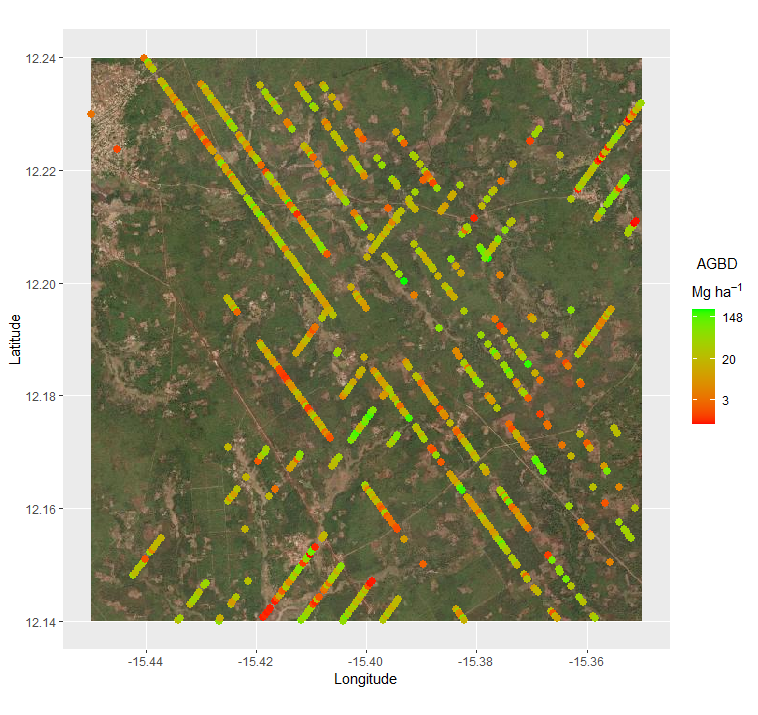
Figure 1. Example subset of aboveground biomass density (AGBD; Mg ha-1) predictions from the GEDI Level-4A footprint product specific to West Africa. The map shows an area centered 4.5 km southeast of Bissora, Guinea-Bissaour, with AGBD predictions spanning October to November 2021. GEDI footprints are spaced 60 m along track and 600 m across-track.
Citation
Duncanson, L., V. Leitold, D. Minor, S. Adu-Bredu, J. Armston, R. Dannunzio, J.G.P. Gamarra, J.A. Gutierrez, N. Hunka, J.R. Kellner, M. Ruiz Villar, R. Tavani, A. Duah-Gyamfi, K.K. Kusi, and R. Valbuena. 2026. West African Footprint-Level GEDI Aboveground Biomass Estimates. ORNL DAAC, Oak Ridge, Tennessee, USA. https://doi.org/10.3334/ORNLDAAC/2475
Table of Contents
- Dataset Overview
- Data Characteristics
- Application and Derivation
- Quality Assessment
- Data Acquisition, Materials, and Methods
- Data Access
- References
- Dataset Revisions
Dataset Overview
This dataset holds revised NASA's Global Ecosystem Dynamics Investigation (GEDI) footprint-level Aboveground Biomass Density estimates for West Africa based on training data only from the region. New field and uninhabited aerial vehicle (UAV) lidar data were collected across a latitudinal gradient in Ghana and used to produce new GEDI West African biomass models, which were applied to on-orbit quality-filtered GEDI data. GEDI mission has been collecting 3-D forest structure data from the International Space Station (ISS) since 2019, and provides global forest aboveground biomass products. One of GEDI's primary science objectives is to produce accurate forest structure and biomass products that are useful for policy applications, including national reporting. In theory, GEDI biomass data are very well suited to fill gaps in National Forest Inventories (NFIs), but only if they are accurate and regionally validated. No West African reference data were included in the generation of GEDI's global biomass products. These refined products should be more accurate in the region and suitable for national reporting and other desired activities in West African countries.
Project: Carbon Monitoring System
The NASA Carbon Monitoring System (CMS) program is designed to make significant contributions in characterizing, quantifying, understanding, and predicting the evolution of global carbon sources and sinks through improved monitoring of carbon stocks and fluxes. The System uses NASA satellite observations and modeling/analysis capabilities to establish the accuracy, quantitative uncertainties, and utility of products for supporting national and international policy, regulatory, and management activities. CMS data products are designed to inform near-term policy development and planning.
Related Publications
Duncanson, L., J.R. Kellner, J. Armston, R. Dubayah, D.M. Minor, S. Hancock, S.P. Healey, P.L. Patterson, S. Saarela, S. Marselis, C.E. Silva, J. Bruening, S.J. Goetz, H. Tang, M. Hofton, B. Blair, S. Luthcke, L. Fatoyinbo, K. Abernethy, A. Alonso, H.-E. Andersen, P. Aplin, T.R. Baker, N. Barbier, J.F. Bastin, P. Biber, P. Boeckx, J. Bogaert, L. Boschetti, P.B. Boucher, D.S. Boyd, D.F.R.P. Burslem, S. Calvo-Rodriguez, J. Chave, R. L. Chazdon, D. B. Clark, D. A. Clark, W. B. Cohen, D. A. Coomes, P. Corona, K.C. Cushman, M. E. J. Cutler, J.W. Dalling, M. Dalponte, J. Dash, S. de-Miguel, S. Deng, P.W. Ellis, B. Erasmus, P.A. Fekety, A. Fernandez-Landa, A. Ferraz, R. Fischer, A.G. Fisher, A. García-Abril, T. Gobakken, J.M. Hacker, M. Heurich, R.A. Hill, C. Hopkinson, H. Huang, S.P. Hubbell, A.T. Hudak, A. Huth, B. Imbach, K.J. Jeffery, M. Katoh, E. Kearsley, D. Kenfack, N. Kljun, N. Knapp, K. Král, M. Krucek, N. Labrière, S.L. Lewis, M. Longo, R.M. Lucas, R. Main, J.A. Manzanera, R.V. Martínez, R. Mathieu, H. Memiaghe, V. Meyer, A. M. Mendoza, A. Monerris, P. Montesano, F. Morsdorf, E. Næsset, L. Naidoo, R. Nilus, M. O’Brien, D.A. Orwig, K. Papathanassiou, G. Parker, C. Philipson, O. L. Phillips, J. Pisek, J.R. Poulsen, H. Pretzsch, C. Rüdiger, S. Saatchi, A. Sanchez-Azofeifa, N. Sanchez-Lopez, R. Scholes, C.A. Silva, M. Simard, A. Skidmore, K. Sterenczak, M. Tanase, C. Torresan, R. Valbuena, H. Verbeeck, T. Vrska, K. Wessels, J.C. White, L.J.T. White, E. Zahabu, and C. Zgraggen. 2022. Aboveground biomass density models for NASA’s Global Ecosystem Dynamics Investigation (GEDI) lidar mission. Remote Sensing of Environment 270:112845. https://doi.org/10.1016/j.rse.2021.112845
Hofton, M.A., and J.B. Blair. 2020. Algorithm Theoretical Basis Document (ATBD) for GEDI Transmit and Receive Waveform Processing for L1 and L2 Products. Goddard Space Flight Center, Greenbelt, MD. https://doi.org/10.5067/DOC/GEDI/GEDI_WF_ATBD.001
Kellner, J.R., J. Armston, and L. Duncanson. 2023. Algorithm theoretical basis document for GEDI footprint aboveground biomass density. Earth and Space Science 10:e2022EA002516. https://doi.org/10.1029/2022EA002516
Related Datasets
Dubayah, R.O., J. Armston, J.R. Kellner, L. Duncanson, S.P. Healey, P.L. Patterson, S. Hancock, H. Tang, J.M. Bruening, M.A. Hofton, J.B. Blair, and S.B. Luthcke. 2022. GEDI L4A Footprint Level Aboveground Biomass Density, Version 2.1. ORNL DAAC, Oak Ridge, Tennessee, USA. https://doi.org/10.3334/ORNLDAAC/2056
- These L4A data were used for filtering the L2A input dataset.
Dubayah, R., M. Hofton, J. Blair, J.,Armston, H.Tang, and S. Luthcke. 2021. GEDI L2A Elevation and Height Metrics Data Global Footprint Level V002. NASA Land Processes Distributed Active Archive Center. https://doi.org/10.5067/GEDI/GEDI02_A.002
- These L2A data were the basis for generating the new estimates for West Africa.
Acknowledgments
This work was supported by the NASA's Carbon Monitoring System’s Biomass Harmonization Activity (grant 80NSSC23K1255) and through an LoA with the Forestry Department at the Food and Agriculture Organization of the United Nations (FAO), funded through the Swedish International Development Agency’s “Global Transformation of Forests for People and Climate" project.
Data Characteristics
Spatial Coverage: 15 West African countries, including: Benin, Burkina Faso, Cabo Verde, Gambia, Ghana, Guinea, Guinea-Bissau, Ivory Coast, Liberia, Mali, Niger, Nigeria, Senegal, Sierra Leone, and Togo
Spatial Resolution: Footprints with ~25 m in diameter
Temporal Coverage: 2019-04-17 to 2023-03-17
Temporal Resolution: One-time estimates
Study Area: Latitude and longitude are given in decimal degrees.
| Site | Westernmost Longitude | Easternmost Longitude | Northernmost Latitude | Southernmost Latitude |
|---|---|---|---|---|
| West Africa | -25.3432 | 14.6531 | 21.7855 | 4.2758 |
Data File Information
This dataset includes 39 files in comma separated values (CSV) format.
The file naming convention is <country>_L4A_predicted_AGB_<PFT>.csv, where
- <country> = three-character ISO3 country code (Table 1)
- <PFT> = plant functional type: "DBT" (deciduous broadleaf forest), "EBT" (evergreen broadleaf forest), or "GSW" (grassland-shrubland-woodland)
Table 1. Country codes used in file names.
| Country | ISO3 Country Code |
|---|---|
| Benin | BEN |
| Burkina Faso | BFA |
| Cabo Verde | CPV |
| Gambia | GMB |
| Ghana | GHA |
| Guinea | GIN |
| Guinea-Bissau | GNB |
| Ivory Coast | CIV |
| Liberia | LBR |
| Mali | MLI |
| Niger | NER |
| Nigeria | NGA |
| Senegal | SEN |
| Sierra Leone | SLE |
| Togo | TGO |
Table 2. Variables in the CSV files.
| Variable | Unit | Description |
|---|---|---|
| filename | - | Original GEDI L4A data file name (HDF5) containing information for the GEDI footprint (see Kellner et al., 2023) |
| shot_number | - | The unique shot number for the GEDI footprint sample |
| lon_lowestmode | degrees east | Longitude center of lowest mode of GEDI sample (see Hofton and Blair, 2020) |
| lat_lowestmode | degrees north | Latitude center of lowest mode GEDI sample (see Hofton and Blair, 2020) |
| elev_lowestmode | m | Elevation of the bottom of the waveform (estimated ground elevation) |
| RH_10 … RH_90 | m | Relative Height metrics, the height below with some % of waveform energy has been returned, relative to the estimated ground elevation (Figure 2). |
| RH_98 | m | Maximum waveform height (the height below which 98% of waveform energy has been returned, relative to estimated ground elevation). This is the height used to predict AGBD. |
| agbd | Mg ha-1 | Aboveground Biomass Density (AGBD) from the original GEDI product |
| agbd_se | Mg ha-1 | Standard error of AGBD from the original GEDI product |
| pft_class | - | Plant functional type from MODIS Landcover Type 5 Classification (e.g. 2=EBT, 4=DBT, 5=Shrub, 6=Grass, etc.) |
| sensitivity | 1 | Signal detection performance metric for the ground detection capability for waveform (see Hofton and Blair, 2020) |
| AGBD | Mg ha-1 | Aboveground biomass density from GEDI revised for West Africa |
| SE | Mg ha-1 | Predicted standard error for West Africa AGBD |
Application and Derivation
NASA's Global Ecosystem Dynamics Investigation (GEDI) mission has been collecting 3-D forest structure data from the International Space Station (ISS) since 2019 and provides global forest aboveground biomass products. One of GEDI's primary science objectives is to produce accurate forest structure and biomass products that are useful for policy applications, including national reporting. In theory, GEDI biomass data are very well suited to fill gaps in National Forest Inventories (NFIs) but only if they are accurate and regionally validated. No West African reference data were included in the generation of GEDI's global biomass products. This revised set of GEDI-based biomass estimates for West Africa is based on training data only from the region. New field and UAV lidar data were collected across a latitudinal gradient in Ghana and used to produce new GEDI West African biomass models, which were applied to on-orbit quality-filtered GEDI. These products should be more accurate in the region and suitable for use in national reporting and other desired activities in West African countries.
Quality Assessment
Uncertainties are estimated for every GEDI footprint following the same statistical approach as the global GEDI L4A products, where Ordinary Least Squares (OLS) model uncertainty is applied to estimate a standard error per footprint. The standard error of each estimate is included in the datasets.
Data Acquisition, Materials, and Methods
The GEDI instrument is aboard the International Space Station (ISS) and its mission aims to characterize ecosystem structure and dynamics to enable improved quantification and understanding of the Earth’s carbon cycle and biodiversity. GEDI is led by the University of Maryland in collaboration with NASA Goddard Space Flight Center. GEDI science data algorithms and products are created by the GEDI Science Team.
The GEDI instrument produces high-resolution laser ranging observations of the 3-dimensional structure of the Earth. GEDI was launched on December 5, 2018, and is attached to the ISS. GEDI collects data globally at the highest resolution and densest sampling of any light detection and ranging (lidar) instrument in orbit to date. The GEDI instrument consists of 3 lasers producing a total of 8 beam ground transects, which consist of ~25 m footprint samples spaced approximately every 60 m along-track. The GEDI beam transects are spaced approximately 600 m apart on the Earth’s surface in the cross-track direction, for an across-track width of ~4.2 km.
Footprint Aboveground Biomass Density (AGBD) is derived from linear parametric models that relate GEDI L2A waveform relative height metrics to aboveground biomass estimates from colocated field plots. The GEDI approach to footprint model selection is data driven. Candidate models for West Africa are stratified by plant functional type (PFT), with square root transformations on the response and predictor variables. The West African GEDI footprint models represent the following combination of PFT’s—deciduous broadleaf trees (DBT), evergreen broadleaf trees (EBT), and combinations of woodlands, grasslands, and shrubs (GSW).
GEDI footprint AGBD is a L4A data product (GEDI04_A), and this product uses the same algorithm development and selection procedures as the global product, but with training data from Ghana, and only strata relevant to the region. Models to produce GEDI04_A were developed using field estimates of AGBD collocated with simulated GEDI waveforms derived from discrete-return airborne lidar (Blair and Hofton, 1999; Hancock et al., 2019). The justification for using simulated GEDI waveforms is that few locations on the land surface are associated with field estimates of AGBD that could be used to train GEDI models. Because GEDI is a sampling mission and most field plots are small, GEDI data will not intersect most of these locations during the mission life. Simulated GEDI waveforms are processed to GEDI02_A equivalent RH metrics, which are defined as the percentage of the received laser waveform intensity that is less than a given height, where height is computed relative to the elevation of the lowest mode in the waveform (Figure 2).
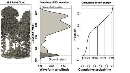
Figure 2. Relative height (RH) metrics were calculated as the height relative to ground elevation under which a certain percentage of waveform energy has been returned. RH50, for example, is the height relative to the ground elevation below which 50% of waveform energy has been returned.
The estimates in this dataset are specific to West Africa countries and were generated from models trained on data from that region. New field and UAV lidar data were collected across a latitudinal gradient in Ghana and used to produce new GEDI West African biomass models, which were applied to on-orbit quality-filtered GEDI. The approach used for estimating aboveground biomass from footprint-level GEDI data is described in Duncanson et al. (2022), and Kellner et al. (2023).
Code availability:
Four Jupyter notebooks have been prepared to provide code examples for training and reproducibility of the results. These notebooks were developed on the ESA-NASA Multimission Algorithm and Analysis Platform (MAAP), which was used for the production of the West Africa biomass data products in this delivery. These notebooks can be accessed here: https://github.com/sepal-contrib/biomass_gedi_west_africa
(1) Create_AGB_Training_Data_Ghana.ipynb: This notebook demonstrates how the field and airborne lidar data were curated once delivered to the University of Maryland. The output from this notebook is an RDS file including plot-level estimates of AGBD, and simulated RH metrics from the GEDI waveform simulator. Note that this step of the processing was not conducted on MAAP, but on a compute cluster at the University of Maryland using scripts developed for data curation for the NASA GEDI database. Therefore, this notebook is designed to enable transparency, and the code in the notebook can be used to do similar data curation. The GEDI simulator code is linked in this notebook and can be publicly accessed as well, and it is documented at the link supplied in the notebook. This notebook was prepared by David Minor under the direction of Laura Duncanson, and questions can be sent to either David or Laura.
(2) Fit_GEDI_agbd_Models_Example.ipynb: This notebook provides an example of a GEDI AGBD model fit. This is an illustrative example, using the outputs from the first notebook and providing models similar to those applied to on-orbit data in the two notebooks described below. Note that the actual model fits used non-public code from the GEDI mission team, and thus the code examples here are provided to assist in the interpretation of the models and as a guide for model fitting in general. The official GEDI mission product uses computationally intensive code to fit a suite of exhaustive OLS models (thousands and thousands of models) and assesses all of these models with available field data. This code is not publicly available (at present), but cumbersome to interpret and run. Therefore, a simplified code example is provided using the constraints that for West Africa models were based on maximum canopy height alone (RH98) and assessed only over Ghana due to data availability.
(3) GEDI_Subsetting_ALL_WA15.ipynb: This notebook shows a functioning example of subsetting GEDI data over an area or country of interest. This notebook can be re-run by anybody with a MAAP account but will not work outside of MAAP. For replication of this step, users should contact the UMD/NASA team (POC Laura Duncanson) to either request an account or request GEDI data subsetting. Generally, the UMD team will be able to process national subsetting of GEDI data quickly and at no cost pending continuation of the NASA MAAP program.
(4) GEDI_Predict_L4A_biomass.ipynb: This notebook takes new GEDI AGBD models (e.g., similar to those in the second notebook) and applies them to on-orbit GEDI data (curated and subset in the third notebook). This notebook produces the final CSV files for each West African country, as well as comparisons between the original (publicly available GEDI_04A) and updated West African products. While this notebook was run on MAAP, the code will work outside MAAP, provided an RDS model (notebook 2) and GEDI subset database (notebook 3) are available.
Note that the notebook examples have many paths to specific user folders on MAAP. If using these notebooks in MAAP, the locations of these folders will need to be changed to the new user. If these notebooks are to be run outside MAAP, these locations will need to be changed to the specific input/output paths in the compute environment used.
Data Access
These data are available through the Oak Ridge National Laboratory (ORNL) Distributed Active Archive Center (DAAC).
West African Footprint-Level GEDI Aboveground Biomass Estimates
Contact for Data Center Access Information:
- E-mail: uso@daac.ornl.gov
- Telephone: +1 (865) 241-3952
References
Blair, J.B., and M.A. Hofton. 1999. Modeling laser altimeter return waveforms over complex vegetation using high-resolution elevation data. Geophysical Research Letters 26:2509-2512. https://doi.org/10.1029/1999GL010484
Dubayah, R.O., J. Armston, J.R. Kellner, L. Duncanson, S.P. Healey, P.L. Patterson, S. Hancock, H. Tang, J.M. Bruening, M.A. Hofton, J.B. Blair, and S.B. Luthcke. 2022. GEDI L4A Footprint Level Aboveground Biomass Density, Version 2.1. ORNL DAAC, Oak Ridge, Tennessee, USA. https://doi.org/10.3334/ORNLDAAC/2056
Dubayah, R., M. Hofton, J. Blair, J.,Armston, H.Tang, and S. Luthcke. 2021. GEDI L2A Elevation and Height Metrics Data Global Footprint Level V002. NASA Land Processes Distributed Active Archive Center. https://doi.org/10.5067/GEDI/GEDI02_A.002
Duncanson, L., J.R. Kellner, J. Armston, R. Dubayah, D.M. Minor, S. Hancock, S.P. Healey, P.L. Patterson, S. Saarela, S. Marselis, C.E. Silva, J. Bruening, S.J. Goetz, H. Tang, M. Hofton, B. Blair, S. Luthcke, L. Fatoyinbo, K. Abernethy, A. Alonso, H.-E. Andersen, P. Aplin, T.R. Baker, N. Barbier, J.F. Bastin, P. Biber, P. Boeckx, J. Bogaert, L. Boschetti, P.B. Boucher, D.S. Boyd, D.F.R.P. Burslem, S. Calvo-Rodriguez, J. Chave, R. L. Chazdon, D. B. Clark, D. A. Clark, W. B. Cohen, D. A. Coomes, P. Corona, K.C. Cushman, M. E. J. Cutler, J.W. Dalling, M. Dalponte, J. Dash, S. de-Miguel, S. Deng, P.W. Ellis, B. Erasmus, P.A. Fekety, A. Fernandez-Landa, A. Ferraz, R. Fischer, A.G. Fisher, A. García-Abril, T. Gobakken, J.M. Hacker, M. Heurich, R.A. Hill, C. Hopkinson, H. Huang, S.P. Hubbell, A.T. Hudak, A. Huth, B. Imbach, K.J. Jeffery, M. Katoh, E. Kearsley, D. Kenfack, N. Kljun, N. Knapp, K. Král, M. Krucek, N. Labrière, S.L. Lewis, M. Longo, R.M. Lucas, R. Main, J.A. Manzanera, R.V. Martínez, R. Mathieu, H. Memiaghe, V. Meyer, A. M. Mendoza, A. Monerris, P. Montesano, F. Morsdorf, E. Næsset, L. Naidoo, R. Nilus, M. O’Brien, D.A. Orwig, K. Papathanassiou, G. Parker, C. Philipson, O. L. Phillips, J. Pisek, J.R. Poulsen, H. Pretzsch, C. Rüdiger, S. Saatchi, A. Sanchez-Azofeifa, N. Sanchez-Lopez, R. Scholes, C.A. Silva, M. Simard, A. Skidmore, K. Sterenczak, M. Tanase, C. Torresan, R. Valbuena, H. Verbeeck, T. Vrska, K. Wessels, J.C. White, L.J.T. White, E. Zahabu, and C. Zgraggen. 2022. Aboveground biomass density models for NASA’s Global Ecosystem Dynamics Investigation (GEDI) lidar mission. Remote Sensing of Environment 270:112845. https://doi.org/10.1016/j.rse.2021.112845
Hancock, S., J. Armston, M. Hofton, X. Sun, H. Tang, L.I. Duncanson, J.R. Kellner, and R. Dubayah. 2019. The GEDI Simulator: a large-footprint waveform lidar simulator for calibration and validation of spaceborne missions. Earth and Space Science 6:294-310. https://doi.org/10.1029/2018EA000506
Hofton, M.A., and J.B. Blair. 2020. Algorithm Theoretical Basis Document (ATBD) for GEDI Transmit and Receive Waveform Processing for L1 and L2 Products. Goddard Space Flight Center, Greenbelt, MD. https://doi.org/10.5067/DOC/GEDI/GEDI_WF_ATBD.001
Kellner, J.R., J. Armston, and L. Duncanson. 2023. Algorithm theoretical basis document for GEDI footprint aboveground biomass density. Earth and Space Science 10:e2022EA002516. https://doi.org/10.1029/2022EA002516
Dataset Revisions
| Version | Release Date | Revision Notes |
|---|---|---|
| 1 | 2026-05-19 | Predicted standard error (SE) values were updated in all files. |
| 1 | 2026-03-20 | First publication |