Documentation Revision Date: 2025-06-09
Dataset Version: 1
Summary
This dataset holds one file in cloud optimized GeoTIFF format.
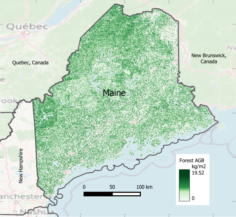
Figure 1. Forest aboveground biomass (AGB) for Maine in 2023. Source: Maine_Biomass_2023.tif
Citation
Ayrey, E., D.J. Hayes, X. Wei, G. Shao, A. Weiskittel, S. Fei, J. Zhao, and B. Zhang. 2025. Forest Aboveground Biomass for Maine, 2023. ORNL DAAC, Oak Ridge, Tennessee, USA. https://doi.org/10.3334/ORNLDAAC/2435
Table of Contents
- Dataset Overview
- Data Characteristics
- Application and Derivation
- Quality Assessment
- Data Acquisition, Materials, and Methods
- Data Access
- References
Dataset Overview
This dataset holds estimates of forest aboveground biomass (AGB) for Maine, USA, in 2023. AGB was estimated using airborne LiDAR data from the USGS 3DEP project and a deep learning convolutional neural network (CNN) model. The airborne LiDAR datasets used in this mapping were collected in different years. The CNN model was calibrated using plot-level forest inventory data with precise location measurements and spectral indices derived from multiple remote sensing products. Stand-level biomass succession models, developed from the USDA Forest Service Forest Inventory and Analysis (FIA) data, were applied to project biomass estimates to the year 2023 with 10-m spatial resolution.
Project: Carbon Monitoring System
The NASA Carbon Monitoring System (CMS) program is designed to make significant contributions in characterizing, quantifying, understanding, and predicting the evolution of global carbon sources and sinks through improved monitoring of carbon stocks and fluxes. The System uses NASA satellite observations and modeling/analysis capabilities to establish the accuracy, quantitative uncertainties, and utility of products for supporting national and international policy, regulatory, and management activities. CMS data products are designed to inform near-term policy development and planning.
Related Publication:
Ayrey, E., D.J. Hayes, J.B. Kilbride, S. Fraver, J.A. Kershaw, B.D. Cook, and A.R. Weiskittel. 2021. Synthesizing disparate LiDAR and satellite datasets through deep learning to generate wall-to-wall regional inventories for the complex, mixed-species forests of the eastern United States. Remote Sensing 13:5113. https://doi.org/10.3390/rs13245113
Acknowledgement:
This research was supported by funding from NASA's Carbon Monitoring System (grants 80NSSC21K0966, 80NSSC25K7219), USDA Forest Service Northeastern States Research Cooperative (grant 20-DG-11242307-025), and USDA NIFA Sustainable Agricultural Systems (grant 2023-68012-38992).
Data Characteristics
Spatial Coverage: Maine, USA
Spatial Resolution: 10 m
Temporal Coverage: 2023-01-01 to 2023-12-31
Temporal Resolution: One time estimate for year 2023
Site Boundaries: Latitude and longitude are given in decimal degrees.
| Site | Westernmost Longitude | Easternmost Longitude | Northernmost Latitude | Southernmost Latitude |
|---|---|---|---|---|
| Maine | -71.3390 | -66.6761 | 47.4611 | 42.9074 |
Data File Information
This dataset holds one file in cloud optimized GeoTIFF format: Maine_Biomass_2023.tif
GeoTIFF characteristics:
- Coordinate system: UTM projection, zone 19N, WGS-84 datum (EPSG 32619), units in meters
- Spatial resolution: 10 m
- Pixel values: aboveground biomass for forest in kg carbon per square meter (kg m-2), range 0 to 19.52 kg m-2
- Nodata value: -999
- Data type: Float32
Application and Derivation
These data are useful for studies of carbon cycling and storage in forest ecosystems.
Quality Assessment
Forest aboveground biomass estimates were compared to data from the Forest Inventory and Analysis database (Woudenberg et al., 2010). The statewide estimates of forest AGB were similar.
Data Acquisition, Materials, and Methods
Airborne LiDAR data from the USGS 3DEP program (https://www.usgs.gov/3d-elevation-program) and a deep learning method Convolutional Neural Network (CNN) were used to map the forest aboveground biomass (AGB) across Maine (Figure 2).
The airborne LiDAR datasets used in this mapping were collected in different years. The CNN model was calibrated using plot-level forest inventory data with precise location measurements and spectral indices derived from multiple remote sensing products. Stand-level biomass succession models (Wei et al., 2025), developed from the USDA Forest Service Forest Inventory and Analysis (FIA) data (Woudenberg et al., 2010), were applied to project biomass estimates to the year 2023 with 10-m spatial resolution.
The methodology is described in detail by Ayrey et al. (2021).
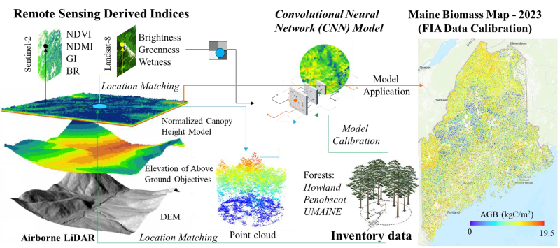
Figure 2. Overview of workflow for estimating forest aboveground biomass for Maine. Details of methodology are described in Ayrey et al. (2021).
Data Access
These data are available through the Oak Ridge National Laboratory (ORNL) Distributed Active Archive Center (DAAC).
Forest Aboveground Biomass for Maine, 2023
Contact for Data Center Access Information:
- E-mail: uso@daac.ornl.gov
- Telephone: +1 (865) 241-3952
References
Ayrey, E., D.J. Hayes, J.B. Kilbride, S. Fraver, J.A. Kershaw, B.D. Cook, and A.R. Weiskittel. 2021. Synthesizing disparate LiDAR and satellite datasets through deep learning to generate wall-to-wall regional inventories for the complex, mixed-species forests of the eastern United States. Remote Sensing 13:5113. https://doi.org/10.3390/rs13245113
Wei, X., D.J. Hayes, A. Weiskittel, and J. Zhao. 2025. Warming-driven shifts in dominant tree species potentially reduce aboveground biomass in northeastern United States forests. Forest Ecology and Management, 580:122536. https://doi.org/10.1016/j.foreco.2025.122536
Woudenberg, S.W., B.L. Conkling, B.M. O'Connell, E.B. LaPoint, J.A. Turner, and K.L. Waddell. 2010. The Forest Inventory and Analysis database: database description and users manual version 4.0 for Phase 2. Gen. Tech. Rep. RMRS-GTR-245. Fort Collins, CO: U.S. Department of Agriculture, Forest Service, Rocky Mountain Research Station. https://doi.org/10.2737/RMRS-GTR-245