Documentation Revision Date: 2023-03-16
Dataset Version: 1
Summary
There are 66 data files in comma-separated values (.csv) format with this dataset.
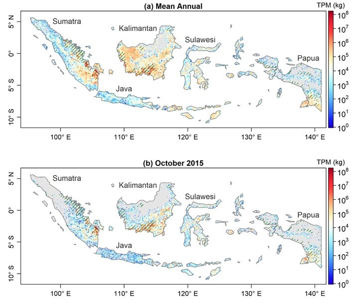
Figure 1. Spatial patterns of the (a) mean annual total particulate matter (TPM) from fire emissions during fire seasons from 2015 to 2020 and (b) TPM from fire emissions in October 2015 across Indonesia. Areas marked with green lines represent peatland areas. Source: Lu et al. (2022).
Citation
Lu, X., X. Zhang, F. Li, and M.A. Cochrane. 2023. Fire Particulate Emissions from Combined VIIRS and AHI Data for Indonesia, 2015-2020. ORNL DAAC, Oak Ridge, Tennessee, USA. https://doi.org/10.3334/ORNLDAAC/2118
Table of Contents
- Dataset Overview
- Data Characteristics
- Application and Derivation
- Quality Assessment
- Data Acquisition, Materials, and Methods
- Data Access
- References
Dataset Overview
This dataset provides 10-minute fire emissions within 0.1-degree regularly spaced intervals across Indonesia from July 2015 to December 2020. The dataset was produced with a top-down approach based on fire radiative energy (FRE) and smoke aerosol emission coefficients (Ce) derived from multiple new-generation satellite observations. Specifically, the Ce values of peatland, tropical forest, cropland, or savanna and grassland were derived from fire radiative power (FRP) and emission rates of smoke aerosols based on Visible Infrared Imaging Radiometer Suite (VIIRS) active fire and aerosol products. FRE for each 0.1-degree interval was calculated from the diurnal FRP cycle that was reconstructed by fusing cloud-corrected FRP retrievals from the high temporal-resolution (10 mins) Himawari-8 Advanced Himawari Imager (AHI) with those from high spatial-resolution (375 m) VIIRS. This new dataset was named the Fused AHI-VIIRS based fire Emissions (FAVE). Fire emissions data are provided in comma-separated values (CSV) format with one file per month from July 2015 to December 2020. Each file includes variables of fire observation time, fire geographic location, classification, fire radiative energy, various fire emissions and related standard deviations.
Project: Carbon Monitoring System (CMS)
The NASA Carbon Monitoring System (CMS) is designed to make significant contributions in characterizing, quantifying, understanding, and predicting the evolution of global carbon sources and sinks through improved monitoring of carbon stocks and fluxes. The System will use the full range of NASA satellite observations and modeling/analysis capabilities to establish the accuracy, quantitative uncertainties, and utility of products for supporting national and international policy, regulatory, and management activities. CMS will maintain a global emphasis while providing finer scale regional information, utilizing space-based and surface-based data and will rapidly initiate generation and distribution of products both for user evaluation and to inform near-term policy development and planning.
Related Publication:
Lu, X., X. Zhang, F. Li, and M.A. Cochrane. 2022. Improved estimation of fire particulate emissions using a combination of VIIRS and AHI data for Indonesia during 2015-2020. Remote Sensing of Environment 281:113238. https://doi.org/10.1016/j.rse.2022.113238
Related Datasets:
Vetrita, Y., and M.A. Cochrane. 2021. Land Use and Cover Maps from Landsat, Mawas, Central Kalimantan, Indonesia, 1994-2019. ORNL DAAC, Oak Ridge, Tennessee, USA. https://doi.org/10.3334/ORNLDAAC/1838
Vetrita, Y., and M.A. Cochrane. 2019. Annual Burned Area from Landsat, Mawas, Central Kalimantan, Indonesia, 1997-2015. ORNL DAAC, Oak Ridge, Tennessee, USA. https://doi.org/10.3334/ORNLDAAC/1708
Acknowledgments:
This work was funded by the NASA Carbon Monitoring System (grants: 80NSSC18K0235, 80NSSC20K0408, and 80NSSC19M0063).
Data Characteristics
Spatial Coverage: Indonesia
Spatial Resolution: Point locations based on satellite observations at 375-m (VIIRS) / 2-km (AHI) resolution, organized within 0.1-degree regular intervals
Temporal Coverage: 2015-07-04 to 2020-12-31
Temporal Resolution: 10 minutes
Study Area: (All latitudes and longitudes given in decimal degrees)
| Study area | Westernmost Longitude | Easternmost Longitude | Northernmost Latitude | Southernmost Latitude |
|---|---|---|---|---|
| Indonesia | 89.0 | 153.0 | 10.0 | -11.0 |
Data File Information:
There are 66 files in comma-separated values (*.csv) format. There is one file for each month from July 2015 to December 2020. In each file, there are 27 columns including variables of fire observation time, geographic location, classification, fire radiative energy, various fire emissions and related standard deviations (Table 1).
The file naming convention is Indonesia_FAVE_Point1deg_10mins_V001_YYYYMM.csv, where:
- Indonesia – is the study area
- FAVE – refers to the "Fused AHI-VIIRS based fire Emissions" model
- Point1deg – refers to the 0.1-degree spacing used to organize the fire observations
- 10mins – refers to the temporal resolution at 10-minute intervals
- V001 – is the version of the product
- YYYYMM – is the year (YYYY) and month (MM) of fire detections
Table 1. Variables in the data files.
| Variable | Units | Description |
|---|---|---|
| column | 1 | Column of 0.1 degree spatial interval (origin at -180.0 longitude, -90.0 latitude) |
| row | 1 | Row of 0.1 degree spatial interval (origin at -180.0 longitude, -90.0 latitude) |
| year | YYYY | Year |
| doy | day_of_year | Local day of year |
| month | month | UTC Month |
| day | day | UTC Day |
| hour | h | Local Hour |
| minute | min | Local Minute |
| longitude | degrees_east | Longitude of raw location of observed fire hotspots by AHI or VIIRS |
| latitude | degrees_north | Latitude of raw location of observed fire hotspots by AHI or VIIRS |
| frp | MW | Fire radiative power in megawatts |
| peat | binary_mask | Peatland: present (1), absent (0) |
| polyid | 1 | Polygon ID: Sumatra (1), Java (2), Kalimantan (3), Sulawesi (4), Papua islands (5) |
| lc | - | Land-cover-type-from-VIIRS (Huang et al., 2022), following-IGBP land-classification |
| fre | MJ | Fire radiative energy in megajoules |
| tpm | kg | Total particulate matter of smoke |
| tpm_sd | kg | Standard deviation of total particulate matter of smoke |
| drymass | kg | Dry mass of consumed biomass |
| carbon | kg | Carbon content of dry mass of consumed biomass |
| co2 | kg | Carbon dioxide emissions |
| co | kg | Carbon monoxide emissions |
| ch4 | kg | Methane emissions |
| pm25 | kg | Fine particulate matter (<=2.5 microns) in smoke aerosols |
| co2_sd | kg | Standard deviation of CO2 emissions |
| co_sd | kg | Standard deviation of CO emissions |
| ch4_sd | kg | Standard deviation of CH4 emissions |
| pm25_sd | kg | Standard deviation of fine particulate matter emissions in smoke aerosols |
Application and Derivation
Indonesia has the largest portion of tropical peatland area and peat carbon (Page et al., 2011). Due to large-scale land use conversion from peat-swamp forests to agricultural plantations, this country has experienced extensive fires and substantial fire emissions, which are severely affecting climate, weather, and human environmental conditions.The improved fire emissions through the combined use of multiple satellite observations are helpful to monitor air quality and visibility, to enhance the modeling of weather, and to quantify the climate and human health impacts at the regional and global scales.
Quality Assessment
Due to the lack of sufficient ground truth data for fire emissions validation, this dataset was evaluated using excess total particulate matter (TPM) derived from the MODIS deep blue aerosol optical depth (AOD) product during Terra and Aqua overpasses over a set of manually selected smoke plumes. The FAVE TPM was significantly correlated with the MODIS AOD-based TPM (r = 0.84; p < 0.001), and the FAVE TPM had an accuracy of 82% (or a difference of 18% from the MODIS AOD-based TPM).
Data Acquisition, Materials, and Methods
The FAVE product was generated using a top-down approach based on fire radiative energy (FRE) and smoke aerosol emission coefficients (Ce) derived from Visible Infrared Imaging Radiometer Suite (VIIRS) and Himawari-8 Advanced Himawari Imager (AHI) fire and aerosol observations between 2015-07-04 and 2020-12-31.
Specifically, Ce was calculated from the relationship between fire radiative power (FRP) and corresponding emission rates of smoke aerosols within a 3×3 pixel window based on 750-m VIIRS fire and AOD products. Calculations were based on the algorithm that was developed using 1-km MODIS FRP and 10-km MODIS AOD products (Ichoku et al., 2014). This algorithm was updated using the latest fire, aerosol, and wind vector products and using Ce values for peatland, tropical forest, cropland, savanna and grassland.
FRE was integrated from the diurnal FRP cycles reconstructed by fusing 10-minute AHI FRP and 375-m VIIRS FRP. First, FRP was recalculated for the AHI version 1.0 fire detections based on collocated radiances at 4-µm from the beta version (JAXA 2020) using a commonly used Mid-Infrared Radiance method (Wooster et al., 2005). Second, cloud corrections were applied to VIIRS FRP and AHI FRP, and further aggregated them into 0.1-degree grids separately. Third, to deal with the fires missed by AHI due to its coarse spatial resolution, the cloud-corrected AHI FRP were adjusted by referencing to the cloud-corrected VIIRS FRP at the time of VIIRS overpasses. Fourth, the fused FRP diurnal cycle was reconstructed from the cloud corrected VIIRS FRP and adjusted AHI FRP for each 0.1-degree grid cell and temporal gaps were filled. Finally, FRE was calculated from the temporal integral of diurnal FRP and the total particulate matter (TPM) of fire emissions was derived using fuel type-specific Ce values. Other fire emissions, such as CO2 and CO, were converted from FAVE TPM based on their emission factor ratios (Andreae 2019).
The fire detections were organized on a 0.1-degree spatial interval having an origin at -180.0 longitude, -90.0 latitude. The dataset includes column and row reference as well as the longitude, latitude coordinates of raw locations of observed fire hotspots (by AHI or VIIRS) for each detection. The raw resolution is 375 m for VIIRS coordinates and 2 km for AHI coordinates.
Refer to Lu et al. (2022) for additional details.
Data Access
These data are available through the Oak Ridge National Laboratory (ORNL) Distributed Active Archive Center (DAAC).
Fire Particulate Emissions from Combined VIIRS and AHI Data for Indonesia, 2015-2020
Contact for Data Center Access Information:
- E-mail: uso@daac.ornl.gov
- Telephone: +1 (865) 241-3952
References
Andreae, M.O. 2019. Emission of trace gases and aerosols from biomass burning–an updated assessment. Atmospheric Chemistry and Physics 19:8523-8546. https://doi.org/10.5194/acp-19-8523-2019
Huang, C., X. Zhan, and I. Csiszar. 2022. Algorithm Theoretical Basis Document For NOAA VIIRS Surface Type. Version 2.1. National Oceanic and Atmospheric Administration, U.S. Department of Commerce. https://www.star.nesdis.noaa.gov/data/pub0008/JPSS/VIIRS-AST/ATBD/ATBD_VIIRS-SurfaceType_V2022.pdf
Ichoku, C., and L. Ellison. 2014. Global top-down smoke-aerosol emissions estimation using satellite fire radiative power measurements. Atmospheric Chemistry and Physics 14:6643- 6667. https://doi.org/10.5194/acp-14-6643-2014
JAXA. 2020. User guide of Himawari-8 AHI active fire product. Japan Aerospace Exploration Agency (JAXA). https://www.eorc.jaxa.jp/ptree/documents/README_H08_L2WLF.txt
Lu, X., X. Zhang, F. Li, and M.A. Cochrane. 2022. Improved estimation of fire particulate emissions using a combination of VIIRS and AHI data for Indonesia during 2015-2020. Remote Sensing of Environment 281:113238. https://doi.org/10.1016/j.rse.2022.113238
Page, S.E., J.O. Rieley, and C.J. Banks. 2011. Global and regional importance of the tropical peatland carbon pool. Global Change Biology 17:798-818. https://doi.org/10.1111/j.1365-2486.2010.02279.x
Vetrita, Y., and M.A. Cochrane. 2021. Land Use and Cover Maps from Landsat, Mawas, Central Kalimantan, Indonesia, 1994-2019. ORNL DAAC, Oak Ridge, Tennessee, USA. https://doi.org/10.3334/ORNLDAAC/1838
Vetrita, Y., and M.A. Cochrane. 2019. Annual Burned Area from Landsat, Mawas, Central Kalimantan, Indonesia, 1997-2015. ORNL DAAC, Oak Ridge, Tennessee, USA. https://doi.org/10.3334/ORNLDAAC/1708
Wooster, M.J., G. Roberts, G. Perry, and Y. Kaufman. 2005. Retrieval of biomass combustion rates and totals from fire radiative power observations: FRP derivation and calibration relationships between biomass consumption and fire radiative energy release. Journal of Geophysical Research: Atmospheres 110:D24311. https://doi.org/10.1029/2005JD006318