Documentation Revision Date: 2021-09-23
Dataset Version: 1
Summary
This dataset includes one compressed shapefile bundle in archive (*.zip) format and a corresponding file in compressed Keyhole-Markup Language (*.kmz) format for convenient viewing using Google Earth.
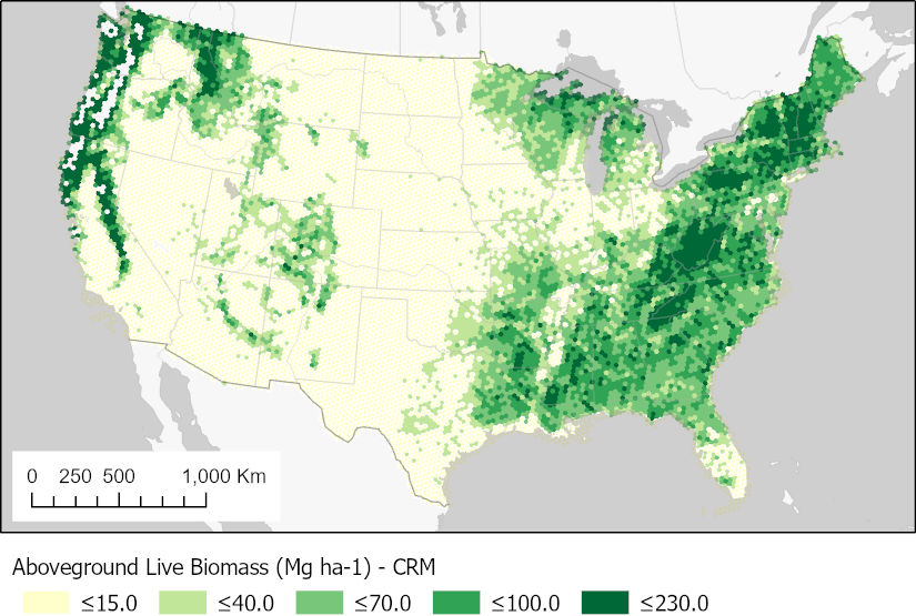
Figure 1. Estimates of aboveground biomass of live trees (diameter >2.54 cm) on forested lands in the conterminous U.S. Estimates were developed from the FIA component ratio method. Source: CONUSbiohex2020.shp
Citation
Menlove, J., and S.P. Healey. 2021. CMS: Forest Aboveground Biomass from FIA Plots across the Conterminous USA, 2009-2019. ORNL DAAC, Oak Ridge, Tennessee, USA. https://doi.org/10.3334/ORNLDAAC/1873
Table of Contents
- Dataset Overview
- Data Characteristics
- Application and Derivation
- Quality Assessment
- Data Acquisition, Materials, and Methods
- Data Access
- References
Dataset Overview
This dataset provides forest biomass estimates for the conterminous United States based on data from the USDA Forest Inventory and Analysis (FIA) program. FIA maintains uniformly measured field plots across the conterminous U.S. This dataset, derived from field survey data from 2009–2019, includes statistical estimates of biomass at the finest scale (64,000-hectare hexagons) allowed by FIA’s sample density. Estimates include the mean (and standard error of the mean) biomass for both live and dead trees, calculated using three sets of allometric equations. There is also an estimate of the area of forestland in each hexagon. These data can be useful for assessing the accuracy of remotely sensed biomass estimates.
Project: Carbon Monitoring System
The NASA Carbon Monitoring System (CMS) program is designed to make significant contributions in characterizing, quantifying, understanding, and predicting the evolution of global carbon sources and sinks through improved monitoring of carbon stocks and fluxes. The System uses NASA satellite observations and modeling/analysis capabilities to establish the accuracy, quantitative uncertainties, and utility of products for supporting national and international policy, regulatory, and management activities. CMS data products are designed to inform near-term policy development and planning.
Related Publication
Menlove, J. and S.P. Healy. 2020. A comprehensive forest biomass dataset for the USA allows customized validation of remotely sensed biomass estimates. Remote Sensing 12:4141. https://doi.org/10.3390/rs12244141
Related Datasets
Collatz, G.J., C. Williams, B. Ghimire, S. Goward, and J. Masek. 2014. CMS: Forest Biomass and Productivity, 1-degree and 5-km, Conterminous US, 2005. ORNL DAAC, Oak Ridge, Tennessee, USA. https://doi.org/10.3334/ORNLDAAC/1221
Fekety, P.A., and A.T. Hudak. 2020. LiDAR Derived Forest Aboveground Biomass Maps, Northwestern USA, 2002-2016. ORNL DAAC, Oak Ridge, Tennessee, USA. https://doi.org/10.3334/ORNLDAAC/1766
Filippelli, S.K., M.J. Falkowski, A.T. Hudak, and P.A. Fekety. 2020. CMS: Pinyon-Juniper Forest Live Aboveground Biomass, Great Basin, USA, 2000-2016. ORNL DAAC, Oak Ridge, Tennessee, USA. https://doi.org/10.3334/ORNLDAAC/1755
Acknowledgments
This work was supported by NASA's Carbon Monitoring System (grant 80HQTR18T0016).
Data Characteristics
Spatial Coverage: Conterminous United States
Spatial Resolution: 640 km2 hexagonal cells
Temporal Coverage: 2009-01-01 to 2019-12-31
Temporal Resolution: Single estimate
Site Boundaries: Latitude and longitude are given in decimal degrees.
| Site | Westernmost Longitude | Easternmost Longitude | Northernmost Latitude | Southernmost Latitude |
|---|---|---|---|---|
| Conterminous U.S. | -125.0094 | -66.6916 | 49.5076 | 24.3192 |
Data File Information
This dataset includes one compressed shapefile bundle in archive (*.zip) format and a corresponding file in compressed Keyhole-Markup Language (*.kmz) format for convenient viewing using Google Earth.
The shapefile CONUSbiohex2020.zip contains polygon features, hexagons 640 km2 in area, extending across the conterminous U.S. The attributes of each hexagon are listed in Table 1.
Data File Details
The Coordinate Reference System is EPSG:4008 (based on the Clarke 1866 ellipsoid).
Table 1. Feature attributes in the shapefile bundle CONUSbiohex2020.zip, and corresponding names and definitions provided in Menlove and Healey (2020).
| Attribute | Publication | Units | Description |
|---|---|---|---|
| USHEXES_ID | USHEXES_ID | Hexagon identifier for FIA database. | |
| EMAP_HEX | EMAP_HEX | FIADB EMAP hexagon identifier. The same as USHEXES_ID in the original EMAP GIS layer. | |
| PROP_FORES | PROP_FOREST | 1.0 | Proportion of the area that is forest land. Ratio of forest land area over sampled area. |
| SE_PROP_FO | SE_PROP_FOREST_PCT | percent | Sampling error of the forest land proportion as a percent of the estimate. |
| CRM_LIVE | CRM_LIVE | Mg ha-1 | Aboveground biomass of live trees (≥2.54 cm diameter) on forest land per hectare of sampled area using FIA component ratio method (CRM). |
| SE_CRM_LIV | SE_CRM_LIVE_PCT | percent | Sampling error of CRM live biomass as a percent of the estimate. |
| CRM_STND_D | CRM_STND_DEAD | Mg ha-1 | Aboveground biomass of standing dead trees (≥12.7 cm diameter) on forest land per hectare of sampled area using FIA component ratio method (CRM). |
| SE_CRM_STN | SE_CRM_STND_DEAD_PCT | percent | Sampling error of CRM standing dead biomass as a percent of the estimate. |
| CRM_LIVE_D | CRM_LIVE_DEAD | Mg ha-1 | Aboveground biomass of live trees (≥2.54 cm diameter) plus standing dead trees (≥5 inches diameter) on forest land per hectare of sampled area using FIA component ratio method (CRM). |
| SE_CRM_L_1 | SE_CRM_LIVE_DEAD_PCT | percent | Sampling error of CRM live plus standing dead biomass as a percent of the estimate. |
| DRYBIOT_LI | DRYBIOT_LIVE | Mg ha-1 | Aboveground biomass of live trees (≥2.54 cm diameter) on forest land per hectare of sampled area using retired FIA regional methods. |
| SE_DRYBIOT | SE_DRYBIOT_LIVE_PCT | percent | Sampling error of aboveground live biomass as a percent of the estimate. |
| DRYBIOT_ST | DRYBIOT_STND_DEAD | Mg ha-1 | Aboveground biomass of standing dead trees (≥12.7 cm diameter) on forest land per hectare of sampled area using retired FIA regional methods. |
| SE_DRYBI_1 | SE_DRYBIOT_STND_DEAD_PCT | percent | Sampling error of standing dead biomass as a percent of the estimate. |
| DRYBIOT__1 | DRYBIOT_LIVE_DEAD | Mg ha-1 | Aboveground biomass of live trees (≥2.54 cm diameter) plus standing dead trees (≥5 inches diameter) on forest land per hectare of sampled area using retired FIA regional methods. |
| SE_DRYBI_2 | SE_DRYBIOT_LIVE_DEAD_PCT | percent | Sampling error of live plus standing dead biomass as a percent of the estimate. |
| JENK_LIVE | JENK_LIVE | Mg ha-1 | Aboveground biomass of live trees (≥2.54 cm diameter) on forest land per hectare of sampled area using the Jenkins equations. |
| SE_JENK_LI | SE_JENK_LIVE_PCT | percent | Sampling error of Jenkins live biomass as a percent of the estimate. |
| JENK_STND_ | JENK_STND_DEAD | Mg ha-1 | Aboveground biomass of standing dead trees (≥12.7 cm diameter) on forest land per hectare of sampled area using the Jenkins equations. |
| SE_JENK_ST | SE_JENK_STND_DEAD_PCT | percent | Sampling error of Jenkins standing dead biomass as a percent of the estimate. |
| JENK_LIVE_ | JENK_LIVE_DEAD | Mg ha-1 | Aboveground biomass of live trees (≥2.54 cm diameter) plus standing dead trees (≥12.7 cm diameter) on forest land per hectare of sampled area using the Jenkins equations. |
| SE_JENK__1 | SE_JENK_LIVE_DEAD_PCT | percent | Sampling error of Jenkins live plus standing dead biomass as a percent of the estimate. |
| EST_SAMPLE | EST_SAMPLED_HA | ha | Sampled hectares in the hexagon. |
| SAMPLED_PL | SAMPLED_PLOTS | count | Number of sampled plots in the hexagon. |
| NON_SAMPLE | NON_SAMPLED_PLOTS | count | Number of non-sampled plots in the hexagon. |
| AVG_INVYR | AVG_INVYR | year | Average of year of field sampling |
Application and Derivation
Brown and Schroeder (1999) used FIA data to estimate forest biomass in the Eastern U.S. at the county level. This new dataset extends this approach to the entire conterminous U.S. and provides biomass estimates at the finest spatial grain supported by FIA’s standard sample intensity, a 640 km2 hexagon. Local-scale statistical estimates, based on ground measurements, may be used to evaluate remotely sensed biomass maps.
Quality Assessment
Each hexagon-level biomass estimate is accompanied by the standard error of that estimate. This formal uncertainty estimate is derived from FIA’s sample design and represents only sampling uncertainty within the hexagon (Woudenberg et al., 2010). Potential field measurement error is disregarded. A major source of uncertainty is the allometry (biometric equations) used to translate the diameter measurements made by FIA into tree-level biomass observations. While allometric error is not considered in the standard error estimates, the dataset allows scrutiny of this factor by presenting population estimates generated by applying different sets of allometry to exactly the same sample for each hex. Allometries considered include: the Component Ratio Method (CRM; Woodall et al., 2011); Jenkins (Jenkins et al., 2004); and an obsolete FIA biomass variable called DRYBIOT.
Data Acquisition, Materials, and Methods
Biomass estimates were derived from field data obtained through the USDA Forest Service’s Forest Inventory and Analysis (FIA) program (Bechtold and Patterson, 2005). FIA collects forest structure metrics across the conterminous United States. The sampling effort is organized by equal-area hexagons of 640 km2. The approximate distance between hexagon centers is 27 km. There are approximately 27 field plots within each hexagon, and each field plot is surveyed every 5–10 years using a standard protocol.
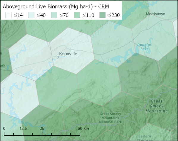
Figure 2. Selected hexagons in the vicinity of the Oak Ridge National Laboratory, Tennessee. Darker green hexagons have higher live biomass values. Source: CONUSbiohex2020.shp
Biomass estimates for each hexagon were derived from measurements pooled from plots with the respective hexagon. Biomass was estimated for living, dead, and both living+dead combined using allometric equations. Estimates were computed using standard FIA techniques (see Appendix J in Woudenberg et al., 2010) as well as two alternative methods: Jenkins allometry (Jenkins et al., 2004) and the Component Ratio Method (CRM; Woodall et al., 2011). The mean and standard error of each estimate is reported. See Table 1 for a list of estimated variables with definitions.
The variable EST_SAMPLED_HA communicates the estimated land area belonging to the U.S. within the hexagon. This number may be needed in some applications to, for example, calculate weighted biomass averages for particular regions. The number given is the FIA sample-based estimate, which is subject to sample error, especially given only ~27 plots per hex. A GIS process will likely return a more accurate number for this variable since both area of land area and administrative boundaries are generally mapped with fairly high accuracy.
See Menlove and Healey (2020) for additional information.
Data Access
These data are available through the Oak Ridge National Laboratory (ORNL) Distributed Active Archive Center (DAAC).
CMS: Forest Aboveground Biomass from FIA Plots across the Conterminous USA, 2009-2019
Contact for Data Center Access Information:
- E-mail: uso@daac.ornl.gov
- Telephone: +1 (865) 241-3952
References
Bechtold, W.A. and P.L. Patterson, (editors). 2005. The enhanced forest inventory and analysis program - national sampling design and estimation procedures. Gen. Tech. Rep. SRS-80. Asheville, NC: U.S. Department of Agriculture, Forest Service, Southern Research Station. https://doi.org/10.2737/SRS-GTR-80
Brown, S.L. and P.E. Schroeder. 1999. Spatial patterns of aboveground production and mortality of woody biomass for Eastern U.S. Forests. Ecological Applications 9:968–980. https://doi.org/10.1890/1051-0761(1999)009[0968:SPOAPA]2.0.CO;2
Jenkins, J.C., D.C. Chojnacky, L.S. Heath, and R.A. Birdsey. 2004. Comprehensive database of diameter-based biomass regressions for North American Tree Species. Gen. Tech. Rep. NE-319. Newtown Square, PA: U.S. Department of Agriculture, Forest Service, Northeastern Research Station. https://doi.org/10.2737/NE-GTR-319
Menlove, J. and S.P. Healy. 2020. A comprehensive forest biomass dataset for the USA allows customized validation of remotely sensed biomass estimates. Remote Sensing 12:4141. https://doi.org/10.3390/rs12244141
Woodall, C.W., L.S. Heath, G.M. Domke, and M.C. Nichols. 2011. Methods and equations for estimating aboveground volume, biomass, and carbon for trees in the US Forest Inventory. Gen. Tech. Rep. NRS-88. Newtown Square, PA: U.S. Department of Agriculture, Forest Service, Northern Research Station. 30 p. https://doi.org/10.2737/NRS-GTR-88
Woudenberg, S.W., B.L. Conkling, B.M. O'Connell, E.B. LaPoint, J.A. Turner, and K.L. Waddell. 2010. The Forest Inventory and Analysis database: database description and users manual version 4.0 for Phase 2. Gen. Tech. Rep. RMRS-GTR-245. Fort Collins, CO: U.S. Department of Agriculture, Forest Service, Rocky Mountain Research Station. https://doi.org/10.2737/RMRS-GTR-245