Documentation Revision Date: 2020-03-26
Dataset Version: 1
Summary
This dataset provides a reference framework on digital soil mapping useful for enabling state and municipal SOC monitoring programs with low computational cost.
There are three data files with this dataset including two GeoTIFF (*.tif) files (estimated SOC and SOC error) and one comma-separated value (*.csv) file with the state summaries.
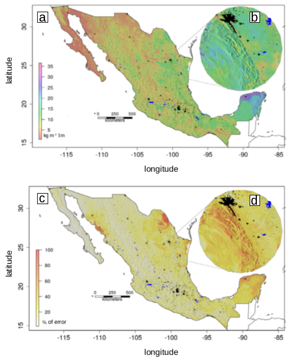
Figure 1. (a) Digital map of soil organic carbon (kg m2) at 1m depth and 90m spatial resolution, the black line represents country borders. The black and blue colored areas are urban areas and water bodies. (b) Zoom in, to an area in northern Mexico to visualize an example of the level of detail achieved by mapping across 90m grids. (c) Percentage of errors in the predictive model (uncertainty map). (d) Zoom in to the error map across an area in northern Mexico to visualize the prediction error with higher spatial detail.
Citation
Guevara, M., and R. Vargas. 2020. Soil Organic Carbon Estimates and Uncertainty at 1-m Depth across Mexico, 1999-2009. ORNL DAAC, Oak Ridge, Tennessee, USA. https://doi.org/10.3334/ORNLDAAC/1754
Table of Contents
- Dataset Overview
- Data Characteristics
- Application and Derivation
- Quality Assessment
- Data Acquisition, Materials, and Methods
- Data Access
- References
Dataset Overview
This dataset provides an estimate of soil organic carbon (SOC) in the top one meter of soil across Mexico at a 90-m resolution for the period 1999-2009. Carbon estimates (kg/m2) are based on a field data collection of 2852 soil profiles by the National Institute for Statistics and Geography (INEGI). The profile data were used for the development of a predictive model along with a set of environmental covariates that were harmonized in a regular grid of 90x90 m2 across all Mexican states. The base of reference was the digital elevation model (DEM) of the INEGI at 90-m spatial resolution (https://www.inegi.org.mx/temas/edafologia/). A model ensemble of regression trees with a recursive elimination of variables explained 54% of the total variability using a cross-validation technique of independent samples. The error associated with the predictive model estimates of SOC is provided. A summary of the total estimated SOC per state, statistical description of the modeled SOC data, and the number of pixels modeled for each state are also provided.
This dataset provides a reference framework on digital soil mapping useful for enabling state and municipal SOC monitoring programs with low computational cost.
Project: Carbon Monitoring System
The NASA Carbon Monitoring System (CMS) is designed to make significant contributions in characterizing, quantifying, understanding, and predicting the evolution of global carbon sources and sinks through improved monitoring of carbon stocks and fluxes. The system will use the full range of NASA satellite observations and modeling/analysis capabilities to establish the accuracy, quantitative uncertainties, and utility of products for supporting national and international policy, regulatory, and management activities. CMS will maintain a global emphasis while providing finer scale regional information, utilizing space-based and surface-based data.
Related Publication
Guevara, M. and R. Vargas. (2020). Soil Organic Carbon Predictions across Mexico at 1m of Soil Depth and 90m of Spatial Resolution (1999-2009). In review.
Referenced in the related publication is this link to GitHub and the R codes that can be used to reproduce these maps: https://github.com/vargaslab/MEXICO/tree/master/soc_map_mx_90m_inegi_s2_bdSaini
Related Dataset
Guevara, M., C.E. Arroyo-cruz, N. Brunsell, C.O. Cruz-gaistardo, G.M. Domke, J. Equihua, J. Etchevers, D.J. Hayes, T. Hengl, A. Ibelles, K. Johnson, B. de Jong, Z. Libohova, R. Llamas, L. Nave, J.L. Ornelas, F. Paz, R. Ressl, A. Schwartz, S. Wills, and R. Vargas. 2020. Soil Organic Carbon Estimates for 30 cm Depth, Mexico and Conterminous USA, 1991-2011. ORNL DAAC, Oak Ridge, Tennessee, USA. https://doi.org/10.3334/ORNLDAAC/1737
Guevara, M., G.F. Olmedo, E. Stell, Y. Yigini, C.A. Hernandez, G. Arevalo, C.E. Arroyo-cruz, A. Bolivar, S. Bunning, N.B. Canas, C.O. Cruz-gaistardo, F. Davila, M.D. Acqua, A. Encina, F. Fontes, J.A.H. Herrera, A.R.I. Navarro, V. Loayza, A.M. Manueles, F.M. Jara, C. Olivera, G. Pereira, P. Prieto, I.A. Ramos, J.C.R. Brina, R. Rivera, J. Rodriguez-Rodriguez, R. Roopnarine, A. Rosales, K.A.R. Rivero, G.A. Schulz, A. Spence, G.M. Vasques, R.R. Vargas, and R. Vargas. 2019. Soil Organic Carbon Stock Estimates with Uncertainty across Latin America. ORNL DAAC, Oak Ridge, Tennessee, USA. https://doi.org/10.3334/ORNLDAAC/1615
Acknowledgments
This research was funded by the Carbon Monitoring Systems (CMS) program, grant number 80NSSC18K017.
Data Characteristics
Spatial Coverage: Mexico
Spatial Resolution: 90 m
Temporal Coverage: 1999-01-01 to 2009-12-31
Temporal Resolution: One-time SOC model predictions
Study Areas (All latitude and longitude given in decimal degrees)
| Sites | Westernmost Longitude | Easternmost Longitude | Northernmost Latitude | Southernmost Latitude |
|---|---|---|---|---|
| Mexico | -117.1242694 | -86.74011389 | 32.71779167 | 14.5328 |
Data File Information
This dataset includes two data files in GeoTIFF (*.tif) format at 90-m resolution and one file of state summaries in comma-separated value (*.csv) format.
Table 1. File names and descriptions.
| File Names | Description |
|---|---|
| soil_organic_carbon_prediction.tif | mapped SOC estimates in kg/m2 |
| soil_organic_carbon_prediction_error.tif | mapped errors of SOC estimates in kg/m2 |
| soil_organic_carbon_per_state.csv | total SOC estimated for each state in Pg, statistical description of the modeled SOC data, and the number of pixels (npixels) modeled for each state |
Data File Details
Properties of the GeoTIFF (.tif) files
- Bands: 1
- No data value: -9999
- Scaling: 1
- Data units: kg/m2
- Map units: degree
- Datum: WGS 1984
- EPSG: 4326
Table 2. Variables in soil_organic_carbon_per_state.csv.
| Variable | Units | Description |
|---|---|---|
| state | State in Mexico | |
| soc | Pg | Total soil organic carbon estimates for each state |
| mean | kg/m2 | Average SOC for state |
| min | kg/m2 | Minimum estimated SOC |
| max | kg/m2 | Maximum estimated SOC |
| sd | kg/m2 | Standard deviation of SOC for state |
| npixels | Number of pixels at 90-m spatial resolution modeled for each state |
Application and Derivation
This study provides a reference framework on digital soil mapping useful for enabling state and municipal SOC monitoring programs with low computational cost. These maps are needed (prediction and prediction error) to support the (NASA-funded) development of soil carbon monitoring systems across Mexico.
Quality Assessment
The modeling approach (random forest) was bootstrapped in a recursive feature elimination framework. The Root Mean Square Error (RMSE) of cross-validated residuals (repeated 5-fold) was used for optimal variable and model parameters. The bootstrapping approach led to independent model residuals that were interpolated using the same validation strategy and the same prediction factors (elevation + enhanced vegetation index + mean precipitation + mean temperature + geology age + topographic position index).
Data Acquisition, Materials, and Methods
The data used for the predictive model of SOC in the states of Mexico were for the period 1999 to 2009 from 2852 profiles described across the national territory by INEGI.
For model development, a set of environmental covariates was harmonized in a regular grid of 90x90 m2 across the Mexican territory. The base of reference was the DEM of INEGI at 90-m spatial resolution. From this DEM, primary topographic attributes were calculated such as the terrain slope and the exposure. Secondary topographic attributes were also calculated such as terrain roughness index, topographic position index, terrain shadow analytic index, and surface flow darkening index.
WorldClim climate information (precipitation and temperature) was used for the period 1970-2000 (Fick and Hijmans, 2017). These precipitation caps and temperature are the input required to calculate the aridity index (evaporation/precipitation) based on the empirical water balance model proposed by Thornthwaite (1948). These climate data have a spatial resolution of 1-km and are harmonized on the 90-m base grid of the DEM while maintaining the same value on all 90-m pixels corresponding to each 1-km pixel. Additional data used included SoilGrids (Hengl et al., 2017) and a satellite product generated by the United States Geological Survey representing the approximate age (in millions of years) of the geology and associated lithological variability (Reuter and Hengl, 2012).
Refer to Guevara, M. and R. Vargas, 2020 (in process), for additional information. Referenced in the related publication is this link to GitHub and the R code that includes all the information required to reproduce these maps: https://github.com/vargaslab/MEXICO/tree/master/soc_map_mx_90m_inegi_s2_bdSaini
Data Access
These data are available through the Oak Ridge National Laboratory (ORNL) Distributed Active Archive Center (DAAC).
Soil Organic Carbon Estimates and Uncertainty at 1-m Depth across Mexico, 1999-2009
Contact for Data Center Access Information:
- E-mail: uso@daac.ornl.gov
- Telephone: +1 (865) 241-3952
References
Fick, S.E. and R.J. Hijmans, 2017. WorldClim 2: new 1-km spatial resolution climate surfaces for global land areas. Int. J. Climatol, 37: 4302-4315. https://doi.org/10.1002/joc.5086
Guevara, M., C.E. Arroyo-cruz, N. Brunsell, C.O. Cruz-gaistardo, G.M. Domke, J. Equihua, J. Etchevers, D.J. Hayes, T. Hengl, A. Ibelles, K. Johnson, B. de Jong, Z. Libohova, R. Llamas, L. Nave, J.L. Ornelas, F. Paz, R. Ressl, A. Schwartz, S. Wills, and R. Vargas. 2020. Soil Organic Carbon Estimates for 30 cm Depth, Mexico and Conterminous USA, 1991-2011. ORNL DAAC, Oak Ridge, Tennessee, USA. https://doi.org/10.3334/ORNLDAAC/1737
Guevara, M., G.F. Olmedo, E. Stell, Y. Yigini, C.A. Hernandez, G. Arevalo, C.E. Arroyo-cruz, A. Bolivar, S. Bunning, N.B. Canas, C.O. Cruz-gaistardo, F. Davila, M.D. Acqua, A. Encina, F. Fontes, J.A.H. Herrera, A.R.I. Navarro, V. Loayza, A.M. Manueles, F.M. Jara, C. Olivera, G. Pereira, P. Prieto, I.A. Ramos, J.C.R. Brina, R. Rivera, J. Rodriguez-Rodriguez, R. Roopnarine, A. Rosales, K.A.R. Rivero, G.A. Schulz, A. Spence, G.M. Vasques, R.R. Vargas, and R. Vargas. 2019. Soil Organic Carbon Stock Estimates with Uncertainty across Latin America. ORNL DAAC, Oak Ridge, Tennessee, USA. https://doi.org/10.3334/ORNLDAAC/1615
Guevara, M. and R. Vargas. 2020. Soil Organic Carbon Predictions across Mexico at 1m of Soil Depth and 90m of Spatial Resolution (1999-2009). In process.
Hengl, T., J.M. de Jesus, G.B.M. Heuvelink, M.R. Gonzalez, M. Kilibarda, A. Blagotic, W. Shangguan, M.N. Wright, X. Geng, B. Bauer-Marschallinger, M.A. Guevara, R. Vargas, R.A. MacMillan, N.H. Batjes, J.G.B. Leenaars, E. Ribeiro, I. Wheeler, S. Mantel, and B. Kempen. (2017). SoilGrids250m: Global gridded soil information based on machine learning. PLoS One, 12(2), e0169748. https://doi.org/10.1371/journal.pone.0169748
Reuter HI, Hengl T. 2012. Worldgrids—a public repository of global soil covariates. In: Miasny B, Malone BP, McBratney AB editors. Digital Soil Assessments and Beyond—Proceedings of the 5th Global Workshop on Digital Soil Mapping. Sydney: CRC Press. pp. 287–292. https://doi.org/10.1201/b12728-57
Thornthwaite, C.W. (1948). An Approach toward a Rational Classification of Climate. Geographical Review, 38(1): 55–94. https://doi.org/10.2307/210739