Documentation Revision Date: 2020-09-17
Dataset Version: 1.1
Summary
There are eight data files in GeoTIFF (.tif) format; one file for each of the eight countries. Each file provides categories of mangrove coverage. The Ganges Delta in Bangladesh and the Can Gio Mangrove Biosphere Reserve in the Mekong Delta, Vietnam, are new additions to this dataset.
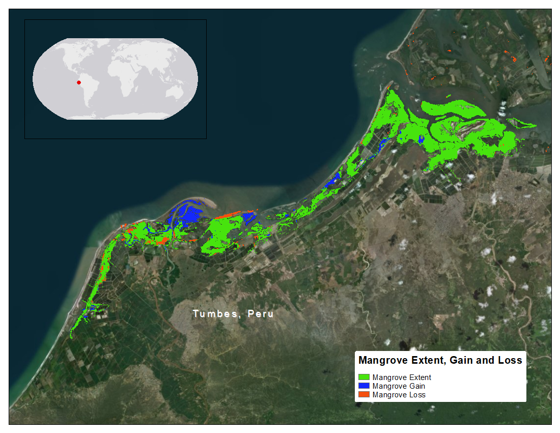
Figure 1. Map of a portion of Peruvian coast showing areas of mangrove extent, gain, and loss from the year 2000 to 2016. Source: mangrove_cover_2000-2016_peru.tif
Citation
Lagomasino, D., T. Fatoyinbo, S. Lee, E. Feliciano, C. Trettin, A. Shapiro, and M. Mwita. 2019. CMS: Mangrove Forest Cover Extent and Change across Major River Deltas, 2000-2016. ORNL DAAC, Oak Ridge, Tennessee, USA. https://doi.org/10.3334/ORNLDAAC/1670
Table of Contents
- Dataset Overview
- Data Characteristics
- Application and Derivation
- Quality Assessment
- Data Acquisition, Materials, and Methods
- Data Access
- References
- Dataset Revisions
Dataset Overview
This dataset provides estimates of mangrove extent for 2016, and mangrove change (gain or loss) from 2000 to 2016, in major river delta regions of eight countries: Bangladesh, Gabon, Jamaica, Mozambique, Peru, Senegal, Tanzania, and Vietnam. For mangrove extent, a combination of Landsat 8 OLI, Sentinel-1 C-SAR, and Shuttle Radar Topography Mission (SRTM) elevation data were used to create country-wide maps of mangrove landcover extent at a 30-m resolution. For mangrove change, the global mangrove map for 2000 (Giri et al., 2010) was used as the baseline. Normalized Difference Vegetation Indices (NDVI) were calculated for every cloud- and shadow-free pixel in the Landsat 5 TM, Landsat 7 ETM+, and Landsat 8 OLI collection and used to create an NDVI anomaly from 2000 to 2016. Areas of change (loss or gain) occurred at the extremes of the cumulative anomalies.
Project: Carbon Monitoring System
The NASA Carbon Monitoring System (CMS) is designed to make significant contributions in characterizing, quantifying, understanding, and predicting the evolution of global carbon sources and sinks through improved monitoring of carbon stocks and fluxes. The System will use the full range of NASA satellite observations and modeling/analysis capabilities to establish the accuracy, quantitative uncertainties, and utility of products for supporting national and international policy, regulatory, and management activities. CMS will maintain a global emphasis while providing finer scale regional information, utilizing space-based and surface-based data and will rapidly initiate generation and distribution of products both for user evaluation and to inform near-term policy development and planning.
Related Publication
Lagomasino, D., Fatoyinbo, T.L., Lee, S.K., Feliciano, E.A., Trettin, C., Shapiro, A.C. and Mangora, M.M., 2019. Measuring mangrove carbon loss and gain in deltas. Environmental Research Letters. https://doi.org/10.1088/1748-9326/aaf0de
Related Datasets
Lagomasino, D., and T. Fatoyinbo. 2016. CMS: Mangrove Canopy Height from High-resolution Stereo Image Pairs, Mozambique, 2012. ORNL DAAC, Oak Ridge, Tennessee, USA. https://doi.org/10.3334/ORNLDAAC/1327
Lagomasino, D., T. Fatoyinbo, S. Lee, E. Feliciano, M. Simard, and C. Trettin. 2016. CMS: Mangrove Canopy Height Estimates from Remote Imagery, Zambezi Delta, Mozambique. ORNL DAAC, Oak Ridge, Tennessee, USA. https://doi.org/10.3334/ORNLDAAC/1357
Lagomasino, D., T. Fatoyinbo, S. Lee, E. Feliciano, C. Trettin, and M.C. Hansen. 2017. CMS: Mangrove Canopy Characteristics and Land Cover Change, Tanzania, 1990-2014. ORNL DAAC, Oak Ridge, Tennessee, USA. https://doi.org/10.3334/ORNLDAAC/1377
Acknowledgments
This work was funded by the NASA Carbon Monitoring Systems project (N4-CMS14-0028), the NASA New Investigator Program (NNX16AK79G), and the USAID/USDA Forest Service SilvaCarbon Bangladesh Program.
Data Characteristics
Spatial Coverage: Gabon, Mozambique, Tanzania, Peru, Senegal, Jamaica, Bangladesh, and Vietnam
Spatial Resolution: 30 m
Temporal Coverage: 2000-01-01 to 2016-12-31
Temporal Resolution: One-time estimates
Study Area: Latitude and longitude are given in decimal degrees.
| Site | Westernmost Longitude | Easternmost Longitude | Northernmost Latitude | Southernmost Latitude |
|---|---|---|---|---|
| Full extent | -82.00023 | 107.0274 | 22.50414 | -28.00014 |
| Bangladesh | 89.89558 | 89.02134 | 22.50414 | 21.61913 |
| Gabon | 13.00014 | 7.99986 | 2.00014 | -5.00014 |
| Jamaica | -79.00014 | -75.99986 | 19.00014 | 16.99986 |
| Mozambique | 41.00014 | 31.99986 | -8.99986 | -28.00014 |
| Peru | -82.00023 | -69.99964 | -2.99978 | -19.00021 |
| Senegal | -18.00014 | -13.99986 | 17.00014 | 11.99986 |
| Tanzania | 41.00014 | 37.99986 | -2.99986 | -11.00014 |
| Vietnam | 107.0274 | 106.7382 | 10.67172 | 10.35668 |
Data File Information
There are eight data files in GeoTIFF (.tif) format; one file for each of the eight countries. Each file provides categories of mangrove coverage. The Ganges Delta in Bangladesh and the Can Gio Mangrove Biosphere Reserve in the Mekong Delta, Vietnam, are new additions to this dataset.
The files are named mangrove_cover_2000-2016_NAME.tif, where NAME is CanGio (Vietnam), Gabon, Ganges (Bangladesh), Jamaica, Mozambique, Peru, Senegal, or Tanzania.
Table 1. Mangrove categories in the GeoTIFF files.
| Category | Description |
|---|---|
| 0 | non-mangrove |
| 1 | mangrove extent |
| 2 | mangrove gain |
| 3 | mangrove loss |
Data File Details
For each file,
Datum: WGS 84
Offered CRS: EPSG 4326
Bands: 1
No data value: 255
Companion File
The file CMS_Mangrove_Cover_ErrorMatrix.pdf provides uncertainties in modeling mangrove land cover change and extent. Bangladesh and Vietnam areas not included.
Application and Derivation
There has been an increasing number of restoration projects in mangrove forests because of the ecosystem’s unique ability to sequester large amounts of carbon. Mangroves account for 2-3 percent of the global forested surface and mangrove deforestation has recently been estimated at between 0.16—0.39 percent per year at regional and global scales. Information on the decline and expansion of mangrove areas is extremely limited, and there is high uncertainty in estimates of total carbon stocks within mangroves owing to dynamic ecosystem changes. To address these uncertainties, a combination of remote sensing and unbiased field inventory datasets have been used.
Quality Assessment
The uncertainties in modeling mangrove land cover change and extent were addressed through a stratified random sampling of
the three class types—extent, loss, and gain. For each country, 200 point locations were selected at random of the extent class and 40—60 point locations for the loss and gain classes. The Accuracy Assessment QGIS plugin was used to quickly cycles through each of the random point locations.
An error matrix table was calculated for each country and is included as a companion file to this dataset. Bangladesh and Vietnam areas not included.
Data Acquisition, Materials, and Methods
Mangrove Extent
The data used to estimate 2016 mangrove landcover consisted of a 30-m resolution Landsat 8 Operational Land Imager (OLI), Sentinel-1 C-SAR, and Shuttle Radar Topography Mission (SRTM) elevation data. Landsat 8 OLI bands were used as inputs for the classification, as well as the normalized band ratios of Normalized Difference Vegetation Index (NDVI), normalized water index, normalized burn ratio, etc. Additionally, annual maximum ‘VV’ and ‘VH’ bands from Sentinel-1 C-SAR and elevation data from SRTM were resampled to the Landsat projection and included in the classification. Data from Landsat provide information on vegetation function and the radar imagery provides information on forest structure. The annual 2016 Landsat composite was classified into mangrove and non mangrove classes.
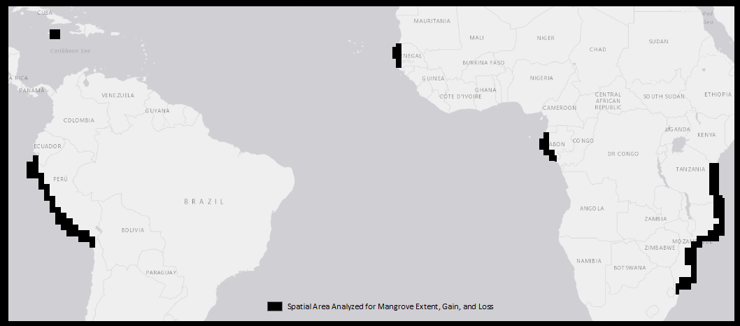
Figure 2. Map showing the areas analyzed for Mangrove Cover in six countries. Vietnam and Bangladesh areas not shown. Files within this dataset cover the shown spatial area, but mangrove cover is limited to the actual occurrence.
Mangrove Cover Change
For mangrove change, the global mangrove map for 2000 (Giri et al, 2010) was used as the baseline. Normalized Difference Vegetation Indices (NDVI) were calculated for every cloud- and shadow-free pixel in the Landsat 5 TM, Landsat 7 ETM+, and Landsat 8 OLI collection and used to create an NDVI anomaly from 2000 to 2016. An NDVI anomaly was calculated for each study region and the anomaly value from each overlapping pixel was then summed across all images in the collection to determine an overall cumulative anomaly. The cumulative anomaly values were also normalized for the total number of images with non-null values for individual pixels. Areas of change (loss or gain) occurred at the extremes of the cumulative anomalies. Change thresholds on the anomalous NDVI values were considered to be those which fell outside the 5th and 95th percentiles over the study region. Values greater than the 95th percentile were considered areas of forested gain, while values less than the 5th percentile were characterized as forested areas that were lost. See Lagomasino et al. (2019) for more information.
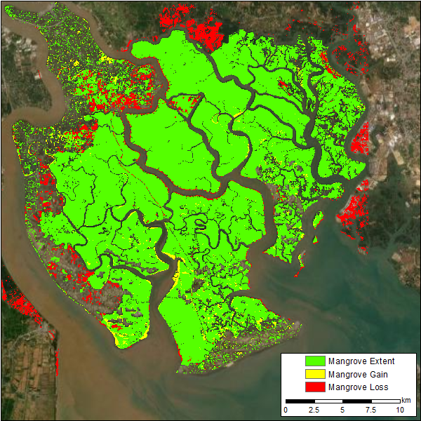
Figure 3. The Can Gio Mangrove Biosphere Reserve in the Mekong Delta, Vietnam, is added with Version 1.1 of this dataset.
Data Access
These data are available through the Oak Ridge National Laboratory (ORNL) Distributed Active Archive Center (DAAC).
CMS: Mangrove Forest Cover Extent and Change across Major River Deltas, 2000-2016
Contact for Data Center Access Information:
- E-mail: uso@daac.ornl.gov
- Telephone: +1 (865) 241-3952
References
Lagomasino, D., Fatoyinbo, T.L., Lee, S.K., Feliciano, E.A., Trettin, C., Shapiro, A.C., and Mangora, M.M. 2019. Measuring mangrove carbon loss and gain in deltas. Environmental Research Letters, 14(2). https://doi.org/10.1088/1748-9326/aaf0de
Giri, C., Ochieng, E., Tieszen, L.L., Zhu, Z., Singh, A., Loveland, T., Masek, J., and Duke, N. 2010. Status and distribution of mangrove forests of the world using earth observation satellite data. Global Ecology and Biogeography, 20(1):154—159. https://doi.org/10.1111/j.1466-8238.2010.00584.x
Dataset Revisions
| Version | Release Date | Revision Notes |
|---|---|---|
| 1.1 | 09/09/2020 | For Version 1.1, the Ganges Delta in Bangladesh and the Can Gio Mangrove Biosphere Reserve in the Mekong Delta, Vietnam, are new data file additions to this dataset. No change to the six previously released data files. |