Documentation Revision Date: 2020-05-15
Dataset Version: 1
Summary
There are 34 GeoTIFF (*.tif) format files provided with this dataset: 17 annual biomass maps and 17 maps of the standard deviation of annual biomass estimates.
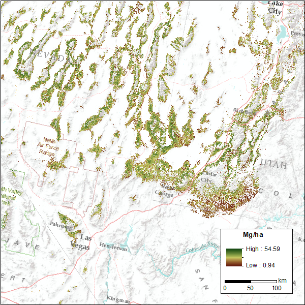
Figure 1: Annual map of live aboveground tree biomass (Mg/ha) for pinyon-juniper forests across a representative portion of the Great Basin of the Western USA for the year 2005 at a spatial resolution of 30 meters. (Source: greatbasin_biomass_2005.tif)
Citation
Filippelli, S.K., M.J. Falkowski, A.T. Hudak, and P.A. Fekety. 2020. CMS: Pinyon-Juniper Forest Live Aboveground Biomass, Great Basin, USA, 2000-2016. ORNL DAAC, Oak Ridge, Tennessee, USA. https://doi.org/10.3334/ORNLDAAC/1755
Table of Contents
- Dataset Overview
- Data Characteristics
- Application and Derivation
- Quality Assessment
- Data Acquisition, Materials, and Methods
- Data Access
- References
Dataset Overview
This dataset provides annual maps of live aboveground tree biomass (Mg/ha) for pinyon-juniper forests across the Great Basin of the Western USA for the years 2000-2016 at a spatial resolution of 30 meters. Biomass estimates are limited to areas of the Great Basin defined as a pinyon-juniper ecosystem type by the 2016 Landfire Existing Vegetation Type map. The estimates of biomass were based on a linear relationship with pinyon-juniper canopy cover and crown-based allometrics developed from field data in Nevada and Idaho. Canopy cover was estimated from remote sensing by using annual composites of Landsat imagery, which were temporally segmented with the LandTrendr algorithm, along with biologically-relevant climate variables, and topographic indices in a Random Forest regression model. Models of canopy cover were trained from semi-automatic extraction of tree crowns from 2011 - 2013 high resolution imagery (1 m) from the National Agriculture Imagery Program, which were validated with photo interpretation. Maps of the standard deviation of biomass estimates from decision trees in the Random Forest model are provided as an indicator of uncertainty. Biomass estimates were calibrated to estimates from the Forest Inventory and Analysis program (FIA) on an annual basis and corrections applied.
Project: Carbon Monitoring System (CMS)
The NASA Carbon Monitoring System (CMS) is designed to make significant contributions in characterizing, quantifying, understanding, and predicting the evolution of global carbon sources and sinks through improved monitoring of carbon stocks and fluxes. The System will use the full range of NASA satellite observations and modeling/analysis capabilities to establish the accuracy, quantitative uncertainties, and utility of products for supporting national and international policy, regulatory, and management activities. CMS will maintain a global emphasis while providing finer scale regional information, utilizing space-based and surface-based data and will rapidly initiate generation and distribution of products both for user evaluation and to inform near-term policy development and planning.
Related Publication:
Filippelli, S.K., Falkowski, M.J., Hudak, A.T., Fekety, P., Vogeler, J.C., Khalyani, A.H., Rau, B.M. and Strand, E.K., 2020. Monitoring pinyon-juniper cover and aboveground biomass across the Great Basin. Environmental Research Letters. https://doi.org/10.1088/1748-9326/ab6785
Related Datasets:
Fekety, P.A., and A.T. Hudak. 2019. Annual Aboveground Biomass Maps for Forests in the Northwestern USA, 2000-2016. ORNL DAAC, Oak Ridge, Tennessee, USA. https://doi.org/10.3334/ORNLDAAC/1719
Fekety, P.A., and A.T. Hudak. 2020. LiDAR Derived Forest Aboveground Biomass Maps, Northwestern USA, 2002-2016. ORNL DAAC, Oak Ridge, Tennessee, USA. https://doi.org/10.3334/ORNLDAAC/1766
Acknowledgement:
This study was supported by NASA’s Carbon Monitoring System Program under grant number NNH15AZ06I.
Data Characteristics
Spatial Coverage: Great Basin of the Western USA
Spatial Resolution: 30 m
Temporal Coverage: 2000-01-01 – 2016-12-31
Temporal Resolution: Annual
Study Area: (all latitudes and longitudes given in decimal degrees)
|
Site |
Westernmost Longitude |
Easternmost Longitude |
Northernmost Latitude |
Southernmost Latitude |
|---|---|---|---|---|
|
Great Basin of the Western USA |
-123.895681 |
-109.311625 |
47.117914 |
33.930909 |
Data File Information
There are 34 GeoTIFF (*.tif) format files provided with this dataset: 17 annual biomass maps and 17 maps of the standard deviation of annual biomass estimates.
|
Filename |
Units |
Description |
|---|---|---|
|
greatbasin_biomass_YYYY.tif |
Mg/ha |
Live aboveground tree biomass for year YYYY, where years are 2000-2016 |
|
greatbasin_biomass_stddev_YYYY.tif |
Mg/ha |
Standard deviation of biomass estimates from decision trees in the Random Forest model for year YYYY, where years are 2000-2016. |
Properties of the GeoTIFF files
Datum: EPSG:5070
Map units: meter
Native datatype: Float32
No data/missing data value: -9999
Scaling: 1
Application and Derivation
Through these maps Filippelli et al. (2020) illustrated trends in Pinyon-Juniper cover and biomass from 2000 to 2016 and compared rates of change between different regions.
Quality Assessment
Precision:
Maps representing the standard deviation of the terminal nodes from the Random Forest predictions are included to provide a measure of pixel-level model precision.
Accuracy:
Maps of estimated canopy cover (i.e. an intermediate product directly related to biomass) were compared to field measurements of canopy cover from the Sagebrush Steppe Treatment Evaluation Project (SageSTEP; McIver et al 2014).
Maps of estimated biomass were compared to FIA estimates at both a plot- and county-level. Mapped Aboveground Biomass (AGB) estimates at FIA plot locations were extracted from the annual map products for the year the plots were measured. Annual bias correction factors were calculated as the ratio of the mean plot-level FIA AGB estimates to the mean of the mapped AGB estimates. The relationship between year and annual bias correction factor was found using linear regression. This line of best fit was used to calculate the bias correction factors for the period 2000 - 2016 ([annual bias correction factor] = -0.004304*[year] + 9.46). Finally, the annual maps were multiplied by the calculated bias correction factor for each year from 2000 to 2016.
See Filippelli, et al. (2020) for additional details.
Data Acquisition, Materials, and Methods
Site Description
This dataset covers the Great Basin watershed of the western United States and extends slightly beyond the watershed to capture nearby areas which are dominated by western juniper, Utah juniper, and/or single-leaf pinyon pine. Although the maps cover the entire region, estimates of biomass are limited to areas classified as a pinyon-juniper type ecosystem by the 2016 Landfire existing vegetation type map.
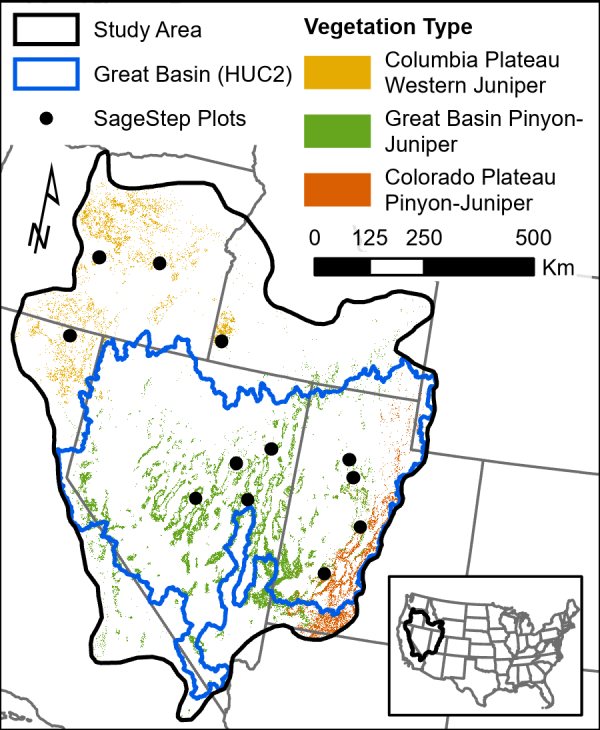
Figure 2. Study area (736,500 km2) and mask of woodlands used for cover and biomass mapping derived from Landfire Existing Vegetation Type (LF2.0.0), and clusters of SageSTEP plots used for validation of canopy cover estimates (Fillipelli et al., 2020). No SageSTEP data are provided.
Temporal extent was limited to 2000–2016 to match the availability of consistently measured USDA Forest Service Forest Inventory and Analysis (FIA) data which we use as a basis of comparison. In 1999 FIA began transitioning from periodic independent collections in each state to collecting a portion of plots annually with a consistent sampling design.
Data Processing
The primary goal of this research was to develop a carbon monitoring, reporting, and verification (MRV) system for Pinyon-Juniper ecosystems across the Great Basin. Following is a brief synopsis of the detailed methods provided in Filippelli, et al. (2020).
Tree Cover
Filippelli, et al. (2020) used a two-stage remote sensing approach using spatial wavelet analysis to identify tree crowns in aerial imagery (Falkowski et al., 2017) at sample locations. Along with topographic indices generated from the National Elevation Dataset (10-m resolution) and variables derived from contemporary climate surfaces (Rehfeldt 2006) which then served as training information for a Random Forest model which mapped tree cover across the region from 2000 to 2016 using temporally segmented Landsat spectral indices obtained from the LandTrendr algorithm in Google Earth Engine.
Applying the LandTrendr algorithm (Kennedy et al., 2010) to Landsat time series in Google Earth Engine then allows us to consistently map cover through time.
Biomass
Annual maps of biomass for the same time period were then mapped using a linear relationship with pinyon-juniper canopy cover and crown-based allometrics developed from previously collected field data in Nevada and Idaho.
Quality Assessment
Maps of cover were compared to field estimates from the SageSTEP project and biomass maps were compared to plot- and county-level biomass estimates from the FIA. Annual biomass maps were multiplied by the calculated bias correction factor for each year from 2000 to 2016. See Section 4 for more details.
Data Access
These data are available through the Oak Ridge National Laboratory (ORNL) Distributed Active Archive Center (DAAC).
CMS: Pinyon-Juniper Forest Live Aboveground Biomass, Great Basin, USA, 2000-2016
Contact for Data Center Access Information:
- E-mail: uso@daac.ornl.gov
- Telephone: +1 (865) 241-3952
References
Falkowski, M.J., Evans, J.S., Naugle, D.E., Hagen, C.A., Carleton, S.A., Maestas, J.D., Khalyani, A.H., Poznanovic, A.J., and Lawrence, A.J., 2017. Mapping tree canopy cover in support of proactive prairie grouse conservation in western North America. Rangeland Ecology and Management, 70(1), 15-24. https://doi.org/10.1016/j.rama.2016.08.002
Filippelli, S.K., Falkowski, M.J., Hudak, A.T., Fekety, P., Vogeler, J.C., Khalyani, A.H., Rau, B.M. and Strand, E.K., 2020. Monitoring pinyon-juniper cover and aboveground biomass across the Great Basin. Environmental Research Letters. https://doi.org/10.1088/1748-9326/ab6785
Kennedy, R.E., Yang, .Z and Cohen, W.B. 2010 Detecting trends in forest disturbance and recovery using yearly Landsat time series: I. LandTrendr—temporal segmentation algorithms Remote Sens. Environ. 114 2897–910. https://doi.org/10.1016/j.rse.2010.07.008
McIver, J., Brunson, M., Bunting, S., Chambers, J., Doescher, P., Grace, J., Hulet, A., Johnson, D., Knick, S., Miller, R., Pellant, M., Pierson, F., Pyke, D., Rau, B., Rollins, K., Roundy, B., Schupp, E., Tausch, R. and Williams J., 2014. A synopsis of short-term response to alternative restoration treatments in sagebrush-steppe: the sageSTEP project Rangel. Ecol. Manage. 67 584–98. https://doi.org/10.2111/REM-D-14-00084.1
Rehfeldt G.E., 2006. A spline model of climate for the Western United States Gen Technical Report RMRS-GTR-165 Fort Collins, CO, US Dep. Agric. For. Serv. Rocky Mt. Res. Stn. 21 p 165 (https://fs.usda.gov/treesearch/pubs/21485)