Documentation Revision Date: 2024-06-06
Dataset Version: 1
Summary
This dataset holds 261 files in cloud-optimized GeoTIFF format.

Figure 1. Status/condition of natural forests for 2020.
Citation
Hunka, N., L. Duncanson, J. Armston, R.O. Dubayah, S.P. Healey, M. Santoro, P. May, A. Araza, C. Bourgain, P.M. Montesano, C.S. Neigh, H. Grantham, V. Potapov, S. Turubanova, A. Tyukavina, J. Richter, N. Harris, M. Urbazaev, A. Pascual, D. Requena Suarez, M. Herold, B. Poulter, S.N. Wilson, G. Grassi, S. Federici, M.J. Sanz Sanchez, and J. Melo. 2024. Classification of Global Forests for IPCC Aboveground Biomass Tier 1 Estimates, 2020. ORNL DAAC, Oak Ridge, Tennessee, USA. https://doi.org/10.3334/ORNLDAAC/2345
Table of Contents
- Dataset Overview
- Data Characteristics
- Application and Derivation
- Quality Assessment
- Data Acquisition, Materials, and Methods
- Data Access
- References
Dataset Overview
This dataset provides classes of global forests delineated by status/condition in 2020 at approximately 30-m resolution. The data support generating Tier 1 estimates for Aboveground dry woody Biomass Density (AGBD) in natural forests in the 2019 Refinement to the 2006 IPCC Guidelines for National Greenhouse Gas Inventories. Forest classes include primary, young secondary (<=20 years), and old secondary forests (>20 years). Classification was based on a Boolean combination of a suite of existing Earth Observation (EO) products of forest tree cover, height, age, and land use classification layers representing years 2000 to 2020. This forest status/condition classification prioritizes the reduction of potential errors of commission in the delineations by minimizing the inclusion of ambiguous pixels. Hence, it provides a conservative estimate of global forest area, identifying approximately 3.26 billion ha of forests worldwide. The classification was created on the collaborative open-science cloud-computing system, the ESA-NASA Multi-mission Analysis and Algorithm Platform (MAAP).
Project: Carbon Monitoring System
The NASA Carbon Monitoring System (CMS) program is designed to make significant contributions in characterizing, quantifying, understanding, and predicting the evolution of global carbon sources and sinks through improved monitoring of carbon stocks and fluxes. The System uses NASA satellite observations and modeling/analysis capabilities to establish the accuracy, quantitative uncertainties, and utility of products for supporting national and international policy, regulatory, and management activities. CMS data products are designed to inform near-term policy development and planning.
Related Publication
Hunka, N., L. Duncanson, J. Armston, R. Dubayah, S.P. Healey, M. Santoro, P. May, A. Araza, C. Bourgoin, P. Montesano, C.S. R. Neigh, H. Grantham, P. Potapov, S. Turubanova, A. Tyukavina, J. Richter, N. Harris, M. Urbazaev, A. Pascual, D.R. Suarez, M. Herold, B. Poulter, S.N. Wilson, G. Grassi, S. Federici, M.J. S. Sanchez, and J. Melo. 2024. Intergovernmental Panel on Climate Change (IPCC) Tier 1 forest biomass estimates from Earth Observation (preprint). https://doi.org/10.22541/au.170958900.06861359/v1
Acknowledgments
This study was funded by the NASA-ESA Multi-mission analysis and algorithm development platform (MAAP), NASA Terrestrial Ecology programs (GEDI contract NNL15AA03C) and NASA Carbon Monitoring Systems 2022 (grant 80NSSC23K1255).
Data Characteristics
Spatial Coverage: Global land
Spatial Resolution: 1 arc-second (~30 m)
Temporal Coverage: data sources covering 2000-01-01 to 2020-12-31
Temporal Resolution: one time estimate for 2020
Study Area: Latitude and longitude are given in decimal degrees
| Site | Westernmost Longitude | Easternmost Longitude | Northernmost Latitude | Southernmost Latitude |
|---|---|---|---|---|
| Global | -180 | 180 | 90 | -90 |
Data File Information
This dataset holds 261 files in cloud optimized GeoTIFF format.
The GeoTIFFs provide global coverage in 10 degree x 10 degree tiles.
The file naming convention is <lat_lon>_Age_Classes.tif, where
- <lat_lon> = the latitude, longitude coordinate of the northwest corner of the tile.
Example file names: 10S_140E_Age_classes.tif, 30N_100E_Age_classes.tif, 50N_030E_Age_classes.tif
GeoTIFF characteristics:
- Coordinate system: geographic coordinates (longitude, latitude), WGS 84 datum, EPSG: 4326
- Spatial resolution: 1 arc-second (~30 m)
- Data type: 16-bit unsigned
- Pixel values: 0 - nodata, 1 - primary forests, 2 - young secondary forests, 3 - old secondary forest
Application and Derivation
Aboveground dry woody Biomass Density (AGBD) maps produced with Earth Observation (EO) data have a large potential to periodically provide a transparent, consistent and replicable picture of the state of the world’s forests. They can comply with the standards mandated by policy, but are yet to be formally adopted in international policy guidance.
The forest status/classification provided in this dataset attempts to replicate the categories for which the IPCC has provided default Tier 1 AGBD estimates, i.e. global natural forests categorized into either primary, young secondary or old secondary forests (see Table 4.7 in IPCC, 2019a). Using such a classification allows the communication of AGBD estimates to the IPCC in a manner comparable and consistent with those mandated by policy. It is recommended to use this dataset when a conservative classification of the world's forests status/condition is required to align with the terminology of the IPCC.
Quality Assessment
These data provide a comprehensive compilation of the latest published datasets on forest conditions, but the nonexistence of any independent sample of global data that would enable the validation of these delineations is a constraint. Hence, the global forest status/condition classification has not been validated.
Data Acquisition, Materials, and Methods
The forest status/condition classification is created by conducting a Boolean analysis of a suite of existing datasets (see Table 1, Hunka et al., 2024, in review), including satellite-derived forest tree cover, height, age, and land use classification layers (Figure 2). In this approach, layers that identify a potential forest status/condition class (e.g. primary forests) are merged, and layers that identify sources of disagreement (e.g. presence of plantations or deforestation detected in the delineated primary forests) are used to remove areas of potential commission errors.
The primary forest class is established using datasets identifying intact/primary forests, with a high forest integrity index, the presence of tree cover and forest heights ≥5 m and no known forest loss events, planted forests or plantations.
The young secondary forest class captures pixels that had changes in forest height or cover between 2000 and 2020, excluding planted forests and plantations. These forests were identified by heights ≥5 m in 2020 and either (a) heights <5 m in 2000 or (b) heights ≥5 m in 2000 but having experienced tree cover loss after 2000.
The old secondary forest class captures the remainder of pixels with forests after excluding the primary and young secondary forest classes. These pixels had forest heights ≥5 m in both 2000 and 2020 with no tree cover loss nor forest disturbances detected after 2000, nor any planted forests or plantations.
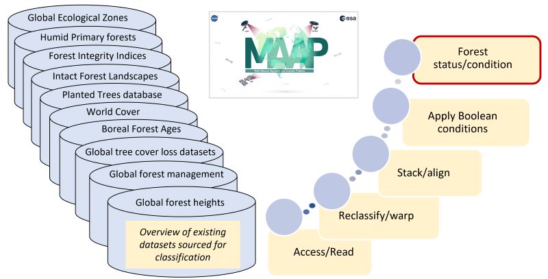
Figure 2. Schematic illustration of approach to forest status/condition classification. The exisiting datasets sourced are described in Hunka et al. (2024, in review).
Data Access
These data are available through the Oak Ridge National Laboratory (ORNL) Distributed Active Archive Center (DAAC).
Classification of Global Forests for IPCC Aboveground Biomass Tier 1 Estimates, 2020
Contact for Data Center Access Information:
- E-mail: uso@daac.ornl.gov
- Telephone: +1 (865) 241-3952
References
IPCC. 2006. IPCC Guidelines for National Greenhouse Gas Inventories, Volume 4: Agriculture, Forestry and Other Land Use. H.S. Eggleston, L. Buendia, K. Miwa, T. Ngara and K. Tanabe (eds). IPCC National Greenhouse Gas Inventories Programme Technical Support Unit; Japan. https://www.ipcc-nggip.iges.or.jp/public/2006gl/vol4.html
IPCC. 2019a. Chapter 4: Forest Land. In 2019 Refinement to the 2006 IPCC Guidelines For National Greenhouse Gas Inventories. E.C. Buendia, S. Guendehou, B. Limmeechokchai, R. Pipatti, Y. Rojas, R. Sturgiss, K. Tanabe, T. Wirth, D. Romano, J. Witi, A. Garg, M.M. Weitz, B. Cai, D.A. Ottinger, H. Dong, J.D. MacDonald, S.M. Ogle, M.T. Rocha, M.J. Sanz Sanchez, D.M. Bartram, and S. Towprayoon (eds). https://www.ipcc-nggip.iges.or.jp/public/2019rf/pdf/4_Volume4/19R_V4_Ch04_Forest%20Land.pdf
IPCC. 2019b. 2019 Refinement to the 2006 IPCC Guidelines for National Greenhouse Gas Inventories. E. Calvo Buendia, K.Tanabe, A. Kranjc, J. Baasansuren, M. Fukuda, S. Ngarize, A. Osako, Y. Pyrozhenko, P. Shermanau, and S. Federici, (eds). Intergovernmental Panel on Climate Change (IPCC); Switzerland. https://www.ipcc-nggip.iges.or.jp/public/2019rf/index.html
Hunka, N., L. Duncanson, J. Armston, R. Dubayah, S.P. Healey, M. Santoro, P. May, A. Araza, C. Bourgoin, P. Montesano, C.S. R. Neigh, H. Grantham, P. Potapov, S. Turubanova, A. Tyukavina, J. Richter, N. Harris, M. Urbazaev, A. Pascual, D.R. Suarez, M. Herold, B. Poulter, S.N. Wilson, G. Grassi, S. Federici, M.J. S. Sanchez, and J. Melo. 2024. Intergovernmental Panel on Climate Change (IPCC) Tier 1 forest biomass estimates from Earth Observation. (preprint). https://doi.org/10.22541/au.170958900.06861359/v1