Documentation Revision Date: 2023-08-23
Dataset Version: 1
Summary
This dataset includes six files in cloud-optimized GeoTIFF (.tif) format.
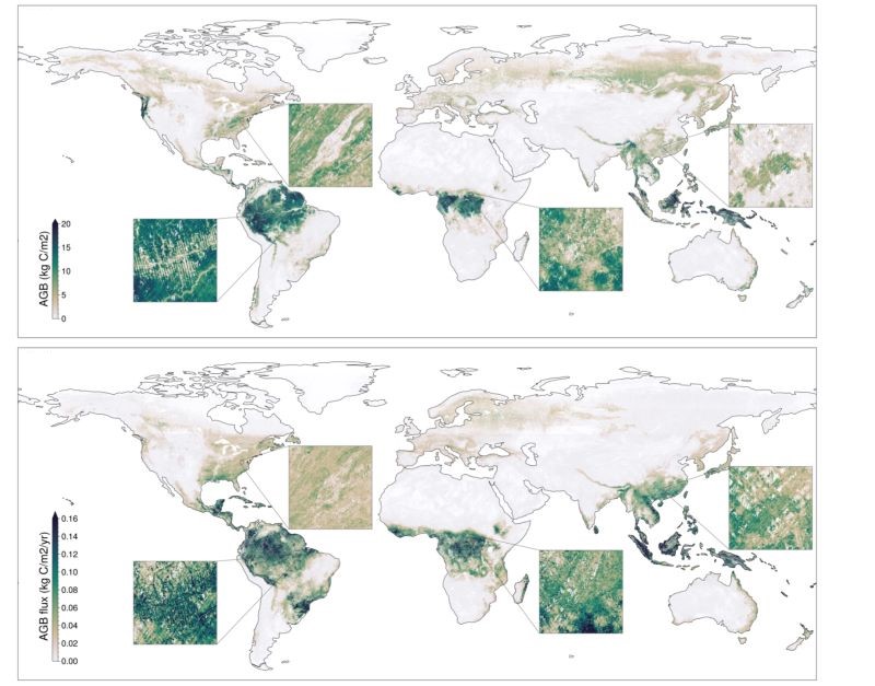
Figure 1. Estimated aboveground carbon stocks (top) and fluxes (bottom) from forest estimated by Ecosystem Demography model using inputs from both GEDI and ICESat-2.
Citation
Ma, L., G.C. Hurtt, H. Tang, R. Lamb, A.J. Lister, L.P. Chini, R.O. Dubayah, J. Armston, E. Campbell, L. Duncanson, S.P. Healey, J. O'Neil-Dunne, L. Ott, B. Poulter, and Q. Shen. 2023. Global Forest Aboveground Carbon Stocks and Fluxes from GEDI and ICESat-2, 2018-2021. ORNL DAAC, Oak Ridge, Tennessee, USA. https://doi.org/10.3334/ORNLDAAC/2180
Table of Contents
- Dataset Overview
- Data Characteristics
- Application and Derivation
- Quality Assessment
- Data Acquisition, Materials, and Methods
- Data Access
- References
Dataset Overview
This dataset provides global gridded estimates of forest aboveground carbon stocks and potential fluxes at a 0.01-degree resolution. It was derived by initializing a newly developed global Ecosystem Demography model (ED v3.0) with novel remote sensing observations of tree canopy height collected by GEDI and ICESat-2, two NASA spaceborne lidar missions. A total of 3.77 billion lidar samples were used to generate gridded canopy height histograms that were then linked to ED simulations of canopy height and carbon dynamics during ecosystem succession. This process constrained representation of contemporary forest conditions and associated carbon stocks and fluxes in the model. Inputs that drove these simulations included meteorology, carbon dioxide levels, and soil properties.
Project: Carbon Monitoring System
The NASA Carbon Monitoring System (CMS) program is designed to make significant contributions in characterizing, quantifying, understanding, and predicting the evolution of global carbon sources and sinks through improved monitoring of carbon stocks and fluxes. The System uses NASA satellite observations and modeling/analysis capabilities to establish the accuracy, quantitative uncertainties, and utility of products for supporting national and international policy, regulatory, and management activities. CMS data products are designed to inform near-term policy development and planning.
Related Publication
Ma, L., G. Hurtt, H. Tang, R. Lamb, A. Lister, L. Chini, R. Dubayah, J. Armston, E. Campbell, L. Duncanson, S. Healey, J. O’Neil-Dunne, L. Ott, B. Poulter, and Q. Shen. 2023. Spatial heterogeneity of global forest aboveground carbon stocks and fluxes constrained by spaceborne lidar data and mechanistic modeling. Global Change Biology, 29, 3378–3394. https://doi.org/10.1111/gcb.16682
Related Datasets
Hurtt, G.C., M. Zhao, R. Sahajpal, A. Armstrong, R. Birdsey, E. Campbell, K. Dolan, R.O. Dubayah, J.P. Fisk, S. Flanagan, C. Huang, W. Huang, K. Johnson, R. Lamb, L. Ma, R. Marks, D. O'Leary III, J. O'Neil-Dunne, A. Swatantran, and H. Tang. 2019. Forest Aboveground Biomass and Carbon Sequestration Potential for Maryland, USA. ORNL DAAC, Oak Ridge, Tennessee, USA. https://doi.org/10.3334/ORNLDAAC/1660
Ma, L., G.C. Hurtt, H. Tang, R. Lamb, E. Campbell, R.O. Dubayah, M. Guy, W. Huang, J. Lu, A. Rudee, Q. Shen, C.E. Silva, and A.J. Lister. 2022b. Forest Aboveground Biomass and Carbon Sequestration Potential, Northeastern USA. ORNL DAAC, Oak Ridge, Tennessee, USA. https://doi.org/10.3334/ORNLDAAC/1922
- Both datasets employ a similar methodology for estimating carbon stocks and fluxes but use different data inputs.
Acknowledgements
This work was supported by NASA's Carbon Monitoring System program (grant: 80NSSC21K1059), NASA contract (NNL15AA03C), and GEDI ST (80HQTR21T0013).
Data Characteristics
Spatial Coverage: Global
Spatial Resolution: 0.01 degree
Temporal Coverage: 2018-10-01 to 2021-10-01
Temporal Resolution: One-time estimate
Study Area: Latitude and longitude are given in decimal degrees
| Site | Westernmost Longitude | Easternmost Longitude | Northernmost Latitude | Southernmost Latitude |
|---|---|---|---|---|
| Global | -180.0 | 180.0 | 90.0 | -90.0 |
Data File Information
This dataset includes six files in cloud-optimized GeoTIFF (.tif) format.
These files hold estimates of aboveground carbon stock in forest in units of kg C per square meter (kg C m-2):
- forest_aboveground_carbon_stock_ED_GEDI.tif
- forest_aboveground_carbon_stock_ED_ICESat2.tif
- forest_aboveground_carbon_stock_ED_GEDI_ICESat2.tif
These files hold estimates of aboveground carbon fluxes in forest in units of kg C per square meter per year (kg C m-2 y-1):
- forest_aboveground_carbon_flux_ED_GEDI.tif
- forest_aboveground_carbon_flux_ED_ICESat2.tif
- forest_aboveground_carbon_flux_ED_GEDI_ICESat2.tif
For each file, the suffixes indicate the lidar data sources used to initiate the Ecosystem Demography (ED) model:
- "ED_GEDI" = Global Ecosystem Dynamics Investigation (GEDI) observations only
- "ED_ICESat2" = Ice, Cloud, and Land Elevation Satellite-2 (ICESat-2) observations only
- "ED_GEDI_ICESat2" = observations from both GEDI and ICESat-2
GeoTIFF properties:
- 1 band
- 18000 rows (10200 rows for GEDI only files) and 36000 columns, scale factor: 1, offset: 0
- Pixel size: 0.01 degree
- Projection: geographic coordinates (longitude, latitude), WGS 84 datum, EPSG: 4326
Application and Derivation
This dataset results from a novel approach that leveraged advances from ecosystem modeling and spaceborne lidar remote sensing. It demonstrates the value of lidar observations of tree structure for advancing carbon modeling at global scale. Multiple-scale evaluations suggested this approach produced favorable estimates relative to other reference data including field inventory, remote sensing-based products and national statistics. However, this approach utilized several orders of magnitude more data on vegetation structure than used previously and enabled a qualitative increase in the spatial resolution of model estimates achievable (from 0.25° to 0.01°). At this resolution, process-based ecosystem models are now able to capture detailed spatial patterns of forest structure previously unattainable, including patterns of natural and anthropogenic disturbance and recovery. This study bridges the gap between existing empirically-based remote sensing approaches and process based modeling approaches. This dataset can set a baseline to monitor forest carbon fluxes and project future forest carbon sequestration potential.
Quality Assessment
This dataset was evaluated by multiple reference datasets at various spatial scales and domains. These reference datasets were derived from different methods including a sample-based forest inventory, remote sensing empirical approaches and ecosystem modeling. For carbon stocks, the reference data included four major sources: 1) gridded remote sensing based AGB maps, 2) inventory data from US Forest Service Forest Inventory Analysis (FIA), and 3) national statistics from Global Forest Resources Assessment (FRA) in 2020 by the Food and Agriculture Organization (FAO), and 4) estimates from ED initialization with land use history dataset LUH2 (Hurtt et al., 2020; Chini et al., 2021). For carbon fluxes, the reference dataset was from ED initialization with LUH2. More details can be found in Ma et al. (2023).
Data Acquisition, Materials, and Methods
The dataset was derived from the height-based lookup table approach that initialized the global Ecosystem Demography model (ED v3.0) (Ma et al., 2022a) with lidar observations of canopy height from NASA's Global Ecosystem Dynamics Investigation (GEDI) and Ice, Cloud, and Land Elevation Satellite-2 (ICESat-2) instruments. The methodological framework includes three major components: model simulations using the ED model, generation of canopy height histogram from lidar data, and model initialization linking these products together (Figure 2).
Model simulations produced a look-up table that consisted of a time series of modeled potential vegetation structure (i.e., canopy height, aboveground biomass, gross primary production, etc.) for each grid cell from bare ground to old-growth indexed by canopy height. Billions of lidar samples from GEDI L2A (Dubayah et al., 2021) and ICESat-2 ATL08 (Neuenschwander et al., 2021) products were gridded into canopy height histograms at 0.01° resolution with bin values ranging from 5 m to 50 m with an equal bin size of 0.5 m. Filtering criteria were applied to exclude low quality data.
Model initialization was a height-based look-up table approach modified here for use of spaceborne lidar data. The initialization approach used tree canopy height in the model as an indicator of forest successional state under the assumption that trees grow taller in size as they develop. Here, considering the sample-based nature of GEDI and ICESat-2 data, a new initialization approach, using the canopy height histogram, was used that captured sub-grid cell variability of heights. Once carbon stocks were initialized, ED was then run forward for 10 years to generate corresponding carbon fluxes. This forward simulation took into account potential natural disturbance and fire but not changes in climate, CO2 concentrations, or land use. The resulting flux represents potential net aboveground carbon fluxes under these controlled conditions, accounting for forest successional state but without losses from land use change and impacts of climate and CO2 fertilization. More details can be found in Ma et al. (2023).
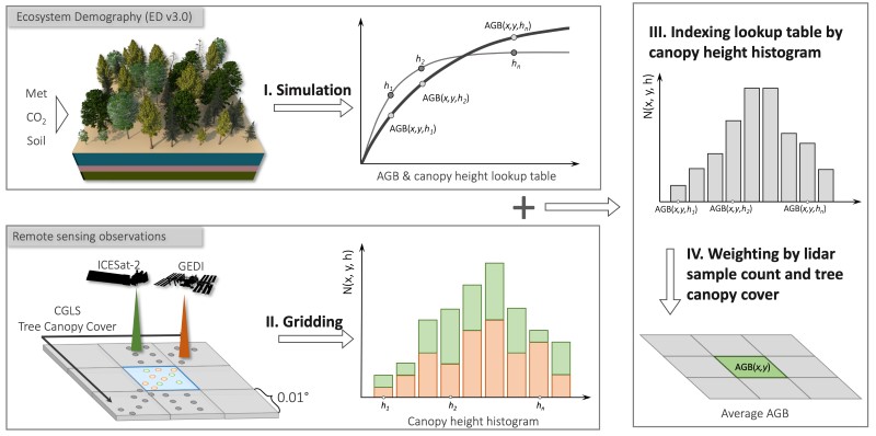
Figure 2. Schematic of the estimation process using the Ecosystem Demography (v3.0) model with input from GEDI and ICESat-2 lidar instruments.
Data Access
These data are available through the Oak Ridge National Laboratory (ORNL) Distributed Active Archive Center (DAAC).
Global Forest Aboveground Carbon Stocks and Fluxes from GEDI and ICESat-2, 2018-2021
Contact for Data Center Access Information:
- E-mail: uso@daac.ornl.gov
- Telephone: +1 (865) 241-3952
References
Chini, L., G. Hurtt, R. Sahajpal, S. Frolking, K. Klein Goldewijk, S. Sitch, R. Ganzenmüller, L. Ma, L. Ott, J. Pongratz, and B. Poulter. 2021. Land-use harmonization datasets for annual global carbon budgets. Earth System Science Data 13: 4175-4189. https://doi.org/10.5194/essd-13-4175-2021
Dubayah, R., M. Hofton, J. Blair, J. Armston, H. Tang, and S. Luthcke. 2021. GEDI L2A Elevation and Height Metrics Data Global Footprint Level V002. NASA EOSDIS Land Processes DAAC, Sioux Falls, South Dakota, USA. https://doi.org/10.5067/GEDI/GEDI02_A.002
Hurtt, G.C., L. Chini, R. Sahajpal, S. Frolking, B.L. Bodirsky, K. Calvin, J.C. Doelman, J. Fisk, S. Fujimori, K. Klein Goldewijk, T. Hasegawa, P. Havlik, A. Heinimann, F. Humpenöder, J. Jungclaus, J.O. Kaplan, J. Kennedy, T. Krisztin, D. Lawrence, P. Lawrence, L. Ma, O. Mertz, J. Pongratz, A. Popp, B. Poulter, K. Riahi, E. Shevliakova, E. Stehfest, P. Thornton, F.N. Tubiello, D.P. van Vuuren, and X. Zhang. 2020. Harmonization of global land use change and management for the period 850–2100 (LUH2) for CMIP6. Geoscientific Model Development 13: 5425-5464. https://doi.org/10.5194/gmd-13-5425-2020
Hurtt, G.C., M. Zhao, R. Sahajpal, A. Armstrong, R. Birdsey, E. Campbell, K. Dolan, R.O. Dubayah, J.P. Fisk, S. Flanagan, C. Huang, W. Huang, K. Johnson, R. Lamb, L. Ma, R. Marks, D. O'Leary III, J. O'Neil-Dunne, A. Swatantran, and H. Tang. 2019. Forest Aboveground Biomass and Carbon Sequestration Potential for Maryland, USA. ORNL DAAC, Oak Ridge, Tennessee, USA. https://doi.org/10.3334/ORNLDAAC/1660
Ma, L., G. Hurtt, H. Tang, R. Lamb, A. Lister, L. Chini, R. Dubayah, J. Armston, E. Campbell, L. Duncanson, S. Healey, J. O’Neil-Dunne, L. Ott, B. Poulter, and Q. Shen. 2023. Spatial heterogeneity of global forest aboveground carbon stocks and fluxes constrained by spaceborne lidar data and mechanistic modeling. Global Change Biology 29: 3378–3394. https://doi.org/10.1111/gcb.16682
Ma, L., G. Hurtt, L. Ott, R. Sahajpal, J. Fisk, R. Lamb, H. Tang, S. Flanagan, L. Chini, A. Chatterjee, and J. Sullivan. 2022a. Global evaluation of the Ecosystem Demography model (ED v3.0). Geoscientific Model Development 15: 1971–1994. https://doi.org/10.5194/gmd-15-1971-2022
Ma, L., G.C. Hurtt, H. Tang, R. Lamb, E. Campbell, R.O. Dubayah, M. Guy, W. Huang, J. Lu, A. Rudee, Q. Shen, C.E. Silva, and A.J. Lister. 2022b. Forest Aboveground Biomass and Carbon Sequestration Potential, Northeastern USA. ORNL DAAC, Oak Ridge, Tennessee, USA. https://doi.org/10.3334/ORNLDAAC/1922
Neuenschwander, A. L., K. L. Pitts, B. P. Jelley, J. Robbins, B. Klotz, S. C. Popescu, R. F. Nelson, D. Harding, D. Pederson, and R. Sheridan. 2021. ATLAS/ICESat-2 L3A Land and Vegetation Height, Version 5. NASA National Snow and Ice Data Center Distributed Active Archive Center, Boulder, Colorado, USA. https://doi.org/10.5067/ATLAS/ATL08.005