Documentation Revision Date: 2024-06-20
Dataset Version: 1
Summary
This dataset includes one file in netCDF format.
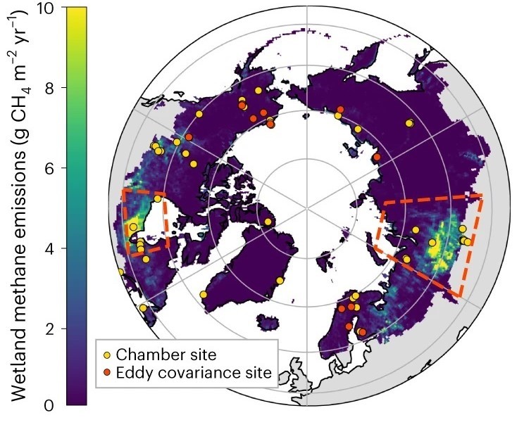
Figure 1. Spatial distribution of the long-term averaged wetland CH4 emissions in the Boreal-Arctic upscaled by combining chamber and eddy covariance datasets. Red dashed boxes indicate two wetland hotpots: Hudson Bay lowlands (50-60 deg N, 75-96 deg W) and Western Siberian lowlands (52-74 deg N, 60-94.5 deg E). Source: Yuan et al. (2024).
Citation
Yuan, K., F. Li, M. Chen, A. Hoyt, S.H. Knox, W. Riley, R. Jackson, and Q. Zhu. 2024. Boreal Arctic Wetland Methane Emissions, 2002-2021. ORNL DAAC, Oak Ridge, Tennessee, USA. https://doi.org/10.3334/ORNLDAAC/2351
Table of Contents
- Dataset Overview
- Data Characteristics
- Application and Derivation
- Quality Assessment
- Data Acquisition, Materials, and Methods
- Data Access
- References
Dataset Overview
This dataset provides an upscaled estimate of Boreal-Arctic wetland CH4 emissions at a weekly time scale from 2002 to 2021 at 0.5 by 0.5-degree spatial resolution. Ground truth data on wetland CH4 emissions from eddy covariance towers (139 site years) and chambers (168 site years) were used to train and validate a causality-guided machine learning model. The trained model was then used to estimate CH4 emissions at grid cells that have wetlands and located above 44 degrees north..
Project: Carbon Monitoring System (CMS)
The NASA Carbon Monitoring System (CMS) program is designed to make significant contributions in characterizing, quantifying, understanding, and predicting the evolution of global carbon sources and sinks through improved monitoring of carbon stocks and fluxes. The System uses NASA satellite observations and modeling/analysis capabilities to establish the accuracy, quantitative uncertainties, and utility of products for supporting national and international policy, regulatory, and management activities. CMS data products are designed to inform near-term policy development and planning.
Related Publication:
Yuan, K., F. Li, G. McNicol, M. Chen, A. Hoyt, S. Knox, W. J. Riley, R. Jackson, and Q. Zhu. 2024. Boreal–Arctic wetland methane emissions modulated by warming and vegetation activity. Nature Climate Change 14:282–288. https://doi.org/10.1038/s41558-024-01933-3
Acknowledgements:
This project received funding from NASA's Carbon Monitoring System (grant NNH20ZDA001N) and from the US Department of Energy's Office of Science through the Reducing Uncertainties in Biogeochemical Interactions through Synthesis and Computation (RUBISCO) Scientific Focus Area Project sponsored by the Earth and Environmental Systems Modeling (EESM) Program, Biological and Environmental Research.
Data Characteristics
Spatial Coverage: Circumpolar arctic above 44 degrees N
Spatial Resolution: 0.5-degree resolution
Temporal Resolution: Weekly
Temporal Coverage: 2002-01-01 to 2021-12-31
Site Boundaries: Latitude and longitude are given in decimal degrees.
| Site | Westernmost Longitude | Easternmost Longitude | Northernmost Latitude | Southernmost Latitude |
|---|---|---|---|---|
| Global | -179.75 | 179.75 | 89.75 | 44.87 |
Data File Information
This dataset includes one file in netCDF format: FCH4_upscale_BorealArctic_weekly_2002-2021.nc.
This netCDF holds gridded data in geographic coordinates (EPSG: 4326) at 0.5 x 0.5 degree resolution.
Grid cells with no data are indicated with a value of -9999.
Table 1. Variables in FCH4_upscale_BorealArctic_weekly_2002-2021.nc.
| Variable | Units | Description |
|---|---|---|
| FCH4_weekly_mean | nmol m-2 s-1 | Estimated mean methane emissions from wetlands for grid cell at a weekly time step covering 2002 to 2021 (52 weeks per year) in units of nmol CH4 m-2 s-1 |
| FCH4_weekly_std | nmol m-2 s-1 | Uncertainty of estimated methane emissions from wetlands for grid cell; standard deviation of mean estimate |
| Boreal_Arctic_mask | 1 | Binary mask. Value of 1 indicates a valid land grid cell in Boreal-Arctic region |
| time | d | Time measured in number of days since 2002-01-01. Value is middle day of each weekly time step. |
| time_bnds | d | Beginning and ending day of each weekly time step, measured in number of days since 2002-01-01. |
Application and Derivation
This dataset is upscaled from 139 and 168 site years of eddy covariance and chamber site measurements with a causality-guide machine learning model (Yuan et al., 2024). The scientific purpose of this dataset is to provide quantitative understanding of long-term dynamics of boreal arctic wetland CH4 emissions, including emission magnitude, inter-annual variability, spatial distribution, and their dominant drivers.
Quality Assessment
The upscaling model was trained and validated with random samples of the site observations. Observations at each site were randomly assigned to one of three groups for purposes of model training (80% of observations), model validation (10%), and model testing (10%).
This training-validation-testing process was repeated with 20 independent random samples of site observations to create trained 20 upscaling models and 20 upscaled datasets of Boreal-Arctic wetland CH4 emissions. The standard deviation of the 20 upscaled datasets was considered as the uncertainty and is included in this dataset.
Data Acquisition, Materials, and Methods
The inputs for the upscaling models included wetland properties, climate, and vegetation. Site observations of methane emissions measured by eddy covariance and chamber sites were used for model training and validation.
Wetland distribution and properties
Grid cells holding wetlands were determined using the Wetland Area and Dynamics for Methane Modeling (WAD2M) dataset for 2002 to 2021 (Zhang et al., 2021). WAD2M was derived from active and passive microwave remote sensing to prescribe wetland extent. The wetland types map from the Boreal-Arctic Wetland and Lake Dataset (BAWLD; Olefeldt et al., 2021) was used to separate wetlands into bogs, fens, marshes and wet tundra. All wetland grid cells in the BAWLD dataset that provided the wetland type information were considered for upscaling.
Climate and vegetation
Soil temperature, air temperature, air pressure, precipitation, wind speed, snow cover, soil water content, and gross primary production (GPP) were used as inputs to calculate wetland CH4 emissions. GPP was obtained from the GOSIF dataset (Li and Xiao, 2019), which was derived on the basis of solar-induced chlorophyll fluorescence (SIF) observed with the Orbiting Carbon Observatory-2 and its linear relationship with GPP. Other variables were obtained from the land component of the fifth generation of European Reanalysis (ERA5-Land) datasets (Munoz-Sabater et al., 2021).
Site observations of wetland CH4 emissions
A comprehensive dataset of CH4 emissions that broadly covered the Boreal–Arctic region was compiled by combining the FLUXNET-CH4 dataset (Knox et al., 2019), BAWLD-CH4 dataset (Kuhn et al., 2021), and the chamber dataset in Bao et al. (2021). All chamber sites that explicitly included the wetland types considered in this work were selected. Quality-assured observed wetland CH4 emissions at eddy covariance sites were used instead of gap-filled data. In total, this study included 139 and 168 site years of eddy covariance and chamber site measurements, respectively.
Additional details are available in Yuan et al. (2024).
Data Access
These data are available through the Oak Ridge National Laboratory (ORNL) Distributed Active Archive Center (DAAC).
Boreal Arctic Wetland Methane Emissions, 2002-2021
Contact for Data Center Access Information:
- E-mail: uso@daac.ornl.gov
- Telephone: +1 (865) 241-3952
References
Bao, T., G. Jia, and X. Xu. 2021. Wetland Heterogeneity Determines Methane Emissions: A Pan-Arctic Synthesis. Environmental Science & Technology 55:10152–10163. https://doi.org/10.1021/acs.est.1c01616
Knox, S., R. Jackson, B. Poulter, G. McNicol, E. Fluet-Chouinard, Z. Zhang, G. Hugelius, P. Bousquet, J. Canadell, M. Saunois, D. Papale, H. Chu, T. Keenan, D. Baldocchi, M. Torn, I. Mammarella, C.Trotta, M. Aurela, G. Bohrer, D. Campbell, A. Cescatti, S. Chamberlain, J. Chen, W. Chen, S. Dengel, A. Desai, E. Euskirchen, T. Friborg, D. Gasbarra, I. Goded, M. Goeckede, M. Heimann, M. Helbig, T. Hirano, D. Hollinger, H. Iwata, M. Kang, J. Klatt, K. Krauss, L. Kutzbach, A. Lohila, B. Mitra, T. Morin, M. Nilsson, S. Niu, A. Noormets, W. Oechel, M. Peichl, O. Peltola, M. Reba, A. Richardson, B. Runkle, Y. Ryu, T. Sachs, K. Schäfer, H. Schmid, N. Shurpali, O. Sonnentag, A. Tang, M. Ueyama, R. Vargas, T. Vesala, E. Ward, L. Windham-Myers, G. Wohlfahrt, and D. Zona. 2019. FLUXNET-CH4 Synthesis Activity: objectives, observations, and future directions. Bulletin of the American Meteorological Society 100:2607-2632. https://doi.org/10.1175/BAMS-D-18-0268.1
Kuhn, M.A., R.K. Varner, D. Bastviken, P. Crill, S. MacIntyre, M. Turetsky, K. Walter Anthony, A.D. McGuire, and D. Olefeldt. 2021. BAWLD-CH4: a comprehensive dataset of methane fluxes from boreal and arctic ecosystems. Earth System Science Data 13:5151–5189. https://doi.org/10.5194/essd-13-5151-2021
Li, X., and J. Xiao. 2019. A Global, 0.05-Degree Product of Solar-Induced Chlorophyll Fluorescence Derived from OCO-2, MODIS, and Reanalysis Data. Remote Sensing 11:517. https://doi.org/10.3390/rs11050517
Muñoz-Sabater, J., E. Dutra, A. Agustí-Panareda, C. Albergel, G. Arduini, G. Balsamo, S. Boussetta, M. Choulga, S. Harrigan, H. Hersbach, B. Martens, D.G. Miralles, M. Piles, N.J. Rodríguez-Fernández, E. Zsoter, C. Buontempo, and J.-N. Thépaut. 2021. ERA5-Land: a state-of-the-art global reanalysis dataset for land applications. Earth System Science Data 13:4349–4383. https://doi.org/10.5194/essd-13-4349-2021
Olefeldt, D., M. Hovemyr, M.A. Kuhn, D. Bastviken, T.J. Bohn, J. Connolly, P. Crill, E.S. Euskirchen, S.A. Finkelstein, H. Genet, G. Grosse, L.I. Harris, L. Heffernan, M. Helbig, G. Hugelius, R. Hutchins, S. Juutinen, M.J. Lara, A. Malhotra, K. Manies, A.D. McGuire, S.M. Natali, J.A. O’Donnell, F.-J.W. Parmentier, A. Räsänen, C. Schädel, O. Sonnentag, M. Strack, S.E. Tank, C. Treat, R.K. Varner, T. Virtanen, R.K. Warren, and J.D. Watts. 2021. The Boreal–Arctic Wetland and Lake Dataset (BAWLD). Earth System Science Data 13:5127–5149. https://doi.org/10.5194/essd-13-5127-2021
Yuan, K., F. Li, G. McNicol, M. Chen, A. Hoyt, S. Knox, W. J. Riley, R. Jackson, and Q. Zhu. 2024. Boreal–Arctic wetland methane emissions modulated by warming and vegetation activity. Nature Climate Change 14:282–288. https://doi.org/10.1038/s41558-024-01933-3
Zhang, Z., E. Fluet-Chouinard, K. Jensen, K. McDonald, G. Hugelius, T. Gumbricht, M. Carroll, C. Prigent, A. Bartsch, and B. Poulter. 2021. Development of the global dataset of Wetland Area and Dynamics for Methane Modeling (WAD2M). Earth System Science Data 13:2001–2023. https://doi.org/10.5194/essd-13-2001-2021