Documentation Revision Date: 2022-03-21
Dataset Version: 1
Summary
The RGGI domain includes the U.S. states of Connecticut, Delaware, Maine, Maryland, Massachusetts, New Hampshire, New Jersey, New York, Pennsylvania, Rhode Island, and Vermont.
There are four data files in GeoTIFF (*.tif) format included in this dataset.
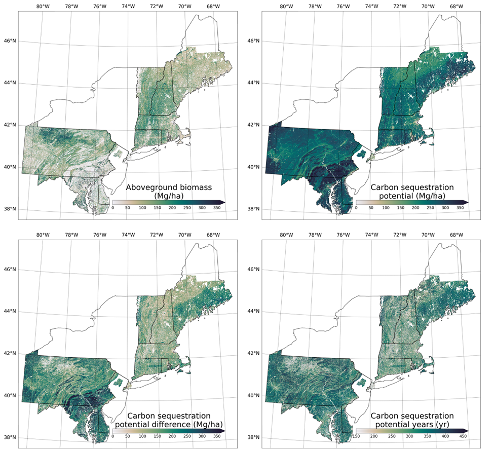
Figure 1. Spatial patterns of forest carbon stores and carbon sequestration potential for the Regional Greenhouse Gas Initiative domain. Maps show aboveground biomass initialized from Ecosystem Demography model (ABG, top left), carbon sequestration potential (CSP, top right), carbon sequestration potential difference (CSP, bottom left), and carbon sequestration potential time gap (time to reach CSP from initialized AGB, bottom right). Source: Ma et al. (2021)
Citation
Ma, L., G.C. Hurtt, H. Tang, R. Lamb, E. Campbell, R.O. Dubayah, M. Guy, W. Huang, J. Lu, A. Rudee, Q. Shen, C.E. Silva, and A.J. Lister. 2022. Forest Aboveground Biomass and Carbon Sequestration Potential, Northeastern USA. ORNL DAAC, Oak Ridge, Tennessee, USA. https://doi.org/10.3334/ORNLDAAC/1922
Table of Contents
- Dataset Overview
- Data Characteristics
- Application and Derivation
- Quality Assessment
- Data Acquisition, Materials, and Methods
- Data Access
- References
Dataset Overview
This dataset provides 90 m estimates of forest aboveground biomass (Mg/ha) for nominal 2011 and projections of carbon sequestration potential for 11 states in the Regional Greenhouse Gas Initiative (RGGI) domain. The RGGI is a cooperative, market-based effort among States in the eastern United States. Estimated biomass and sequestration potential were computed using the Ecosystem Demography (ED) model. The ED Model integrates several key data including climate variables from Daymet and MERRA2 products; physical soil and hydraulic properties from Probabilistic Remapping of SSURGO (POLARIS) and CONUS-SOIL; land cover characteristics from airborne lidar, the National Agriculture Imagery Program (NAIP), and the National Land Cover Database (NLCD); and vegetation parameters from the Forest Inventory and Analysis (FIA) Program.
The RGGI domain includes the U.S. states of Connecticut, Delaware, Maine, Maryland, Massachusetts, New Hampshire, New Jersey, New York, Pennsylvania, Rhode Island, and Vermont.
Project: Carbon Monitoring System
The NASA Carbon Monitoring System (CMS) program is designed to make significant contributions in characterizing, quantifying, understanding, and predicting the evolution of global carbon sources and sinks through improved monitoring of carbon stocks and fluxes. The System uses NASA satellite observations and modeling/analysis capabilities to establish the accuracy, quantitative uncertainties, and utility of products for supporting national and international policy, regulatory, and management activities. CMS data products are designed to inform near-term policy development and planning.
Related Publications
Lamb, R.L., G.C. Hurtt, T.J. Boudreau, E. Campbell, E.A. Sepúlveda Carlo, H.-H. Chu, J. de Mooy, R.O. Dubayah, D. Gonsalves, M. Guy, N.E. Hultman, S. Lehman, B. Leon, A.J. Lister, C. Lynch, L. Ma, C. Martin, N. Robbins, A. Rudee, C.E. Silva, C. Skoglund, and H. Tang. 2021. Context and future directions for integrating forest carbon into sub-national climate mitigation planning in the RGGI region of the U.S. Environmental Research Letters 16:063001. https://doi.org/10.1088/1748-9326/abe6c2
Ma, L., G. Hurtt, H. Tang, R. Lamb, E. Campbell, R. Dubayah, M. Guy, W. Huang, A. Lister, J. Lu, J. O’Neil-Dunne, A. Rudee, Q. Shen, and C. Silva. 2021. High-resolution forest carbon modelling for climate mitigation planning over the RGGI region, USA. Environmental Research Letters 16:045014. https://doi.org/10.1088/1748-9326/abe4f4
Tang, H., L. Ma, A. Lister, J. O’Neill-Dunne, J. Lu, R.L. Lamb, R. Dubayah, and G. Hurtt. 2021. High-resolution forest carbon mapping for climate mitigation baselines over the RGGI region, USA. Environmental Research Letters 16:035011. https://doi.org/10.1088/1748-9326/abd2ef
Related Datasets
Dubayah, R.O., Swatantran A., Huang W., Duncanson L., Johnson K., Tang H., O'Neil-Dunne J., and Hurtt G.C. 2018. LiDAR Derived Biomass, Canopy Height and Cover for Tri-State (MD, PA, DE) Region, V2. ORNL DAAC, Oak Ridge, Tennessee, USA.https://doi.org/10.3334/ORNLDAAC/1538
Kellndorfer, J., W. Walker, K. Kirsch, G. Fiske, J. Bishop, L. LaPoint, M. Hoppus, and J. Westfall. 2013. NACP Aboveground Biomass and Carbon Baseline Data, V. 2 (NBCD 2000), U.S.A., 2000. ORNL DAAC, Oak Ridge, Tennessee, U.S.A.http://dx.doi.org/10.3334/ORNLDAAC/1161
Tang, H., L. Ma, A.J. Lister, J. O'Neil-Dunne, J. Lu, R. Lamb, R.O. Dubayah, and G.C. Hurtt. 2021. LiDAR Derived Biomass, Canopy Height, and Cover for New England Region, USA, 2015. ORNL DAAC, Oak Ridge, Tennessee, USA. https://doi.org/10.3334/ORNLDAAC/1854
Acknowledgments
This work received funding from NASA’s Carbon Monitoring System (CMS) project (grant 80NSSC17K0710) and New Investigator Program (80NSSC18K0708).
Data Characteristics
Spatial Coverage: Northeastern U.S., from Maryland to Maine
Spatial Resolution: 90 m
Temporal Resolution: One-time estimate for year 2011
Temporal Coverage: 2011-01-01 to 2011-12-31
Study Area: All latitude and longitude are given in decimal degrees.
| Site | Westernmost Longitude | Easternmost Longitude | Northernmost Latitude | Southernmost Latitude |
|---|---|---|---|---|
| Northeastern U.S. | -81.2257 | -66.0583 | 49.0223 | 36.8037 |
Data File Information
There are four data files in GeoTIFF (*.tif) format included in this dataset. These raster files hold estimates of aboveground biomass in forest and biomass for carbon sequestration potential for the Regional Greenhouse Gas Initiative (RGGI) domain, including portions of Connecticut, Delaware, Maine, Maryland, Massachusetts, New Hampshire, New Jersey, New York, Pennsylvania, Rhode Island, and Vermont.
Table 1. File information and descriptions.
| File Name | Units | Description |
|---|---|---|
| above_ground_biomass.tif | Mg ha-1 | Estimated aboveground biomass in forests |
| carbon_sequestration_potential.tif | Mg ha-1 | Estimated potential for carbon sequestration in forest biomass. 95% of maximum forest aboveground biomass after 500 years of succession |
| carbon_sequestration_potential_difference.tif | Mg ha-1 | Difference between aboveground biomass in 2011 and potential for carbon sequestration |
| carbon_sequestration_potential_years.tif | y | Estimated time, in years from 2011, to reach carbon sequestration potential |
Data File Details
For all files, the spatial resolution is 90 m, and the no data value is represented as -9999. The coordinate reference system is "Albers Conic Equal Area-North America," datum NAD83 (EPSG:42303). Each file has 10,980 columns and 12,982 rows.
The units for biomass estimates are megagrams biomass per hectare (Mg ha-1). To convert biomass to carbon units (Mg C ha-1), multiply map values by 0.5.
Application and Derivation
Planning for climate change mitigation requires models able to project potential future carbon stocks, and forests play a critical role in carbon sequestration. This dataset results from an updated and expanded high-resolution forest carbon modelling approach previously developed for the state of Maryland (Hurtt et al., 2019). The model was expanded to 11 states in the Regional Greenhouse Gas Initiative (RGGI) domain, which includes Connecticut, Delaware, Maine, Maryland, Massachusetts, New Hampshire, New Jersey, New York, Pennsylvania, Rhode Island, and Vermont. For the eight states with complete data, an area of 228,552 km2, the contemporary forest aboveground carbon stock was estimated to be 1,134 Tg C, and the difference between 2011 C stocks and the forest aboveground carbon sequestration potential was estimated to be >1,770 Tg C (Ma et al., 2021).
Quality Assessment
Uncertainties associated with aboveground biomass estimates were quantified by 4,540 plots from US Forest Service Forest Inventory and Analysis (FIA). Uncertainties associated with projections of carbon sequestration potential and carbon sequestration potential difference were quantified by a sensitivity analysis which assessed how changes in net primary productivity (NPP) and disturbance rate alter estimates of future carbon dynamics.
Aboveground biomass estimates show moderate agreement with fine-scale biomass variation in FIA plots and stronger agreement with empirical estimates from lidar. Estimates were similar to other existing biomass products at the broader state-level scale.
See Ma et al. (2021) for details.
Data Acquisition, Materials, and Methods
This project used a high-resolution forest carbon modelling approach to estimate aboveground biomass forest and assess the potential for carbon sequestration in forest ecosystems. The approach was applied to portions of 11 U.S. states in the Regional Greenhouse Gas Initiative (RGGI) domain, which includes Connecticut, Delaware, Maine, Maryland, Massachusetts, New Hampshire, New Jersey, New York, Pennsylvania, Rhode Island, and Vermont.
The study employed an updated version of the Ecosystem Demography (ED) model version 3.0 (Ma et al., 2022), an improved lidar initialization strategy, and an expanded calibration/validation approach. The ED model integrates submodules of plant demography, hydrology, carbon cycle, and soil biogeochemistry. ED can track plant dynamics including growth, mortality, and reproduction; carbon dynamics within the simulated plants; and dynamics of carbon pools in forest ecosystems. The effects of disturbance, such fire and timber harvest, can be included. ED explicitly tracks vegetation structure and scales fine-scale physiological processes to large-scale ecosystem dynamics (Hurtt et al., 1998; Fisher et al., 2018; Ma et al., 2022).
In this study, model inputs included meteorological data from NASA Daymet and Modern-Era Retrospective analysis for Research and Applications, Version 2 (MERRA2); soil properties from Probabilistic Remapping of SSURGO (POLARIS) (Chaney et al., 2016) and CONUS-SOIL (Miller and White 1998); forest structure from lidar-derived canopy height (O'Neil-Dunne et al., 2014) and canopy fractional coverage from imagery from National Agricultural Imagery Program (NAIP); and 2011 landcover from the National Landcover Dataset. These datasets were harmonized to the resolution of 90 m.
Model initialization linked forest canopy height and canopy fraction with ED simulations to estimate contemporary forest AGB and future carbon sequestration potential. Canopy height was linked to the ED model through a lookup table, whereby canopy height metrics were used to index associated state variables in the model. To establish the look-up table, ED was run for each grid cell from initial seedlings for 500 years of succession, which produced a time series of AGB and canopy height metrics.
The ED model was initialized with aboveground biomass (ABG) estimated from lidar data for the year 2011, and the resulting aboveground biomass estimates set a baseline for future carbon sequestration. These initial estimates were validated by comparison to Forest Inventory and Analysis (FIA) plot data from the USDA Forest Service. They were also compared to aboveground biomass maps from lidar-informed empirical models (Huang et al., 2019; Tang et al., 2021), and other existing biomass products (Blackard et al., 2008; Saatchi et al., 2012; Kellndorfer et al., 2013; Wilson et al., 2013; Santoro 2018).
Future carbon sequestration was calculated from both the continued growth of existing trees and newly reforested lands. Following Hurtt et al. (2019), projection-related metrics were derived: carbon sequestration potential (CSP) was defined as 95% of the future maximum ABG supported by the land after 500 years of succession, the carbon sequestration potential gap (CSPG) was defined as the difference between CSP and 2011 AGB, and the carbon sequestration potential time gap was defined as the time in years required to reach CSP from 2011 AGB (Ma et al., 2011).
Future projections were computed using the ED model under contemporary climate conditions. Land cover of wetland, inland water, and the impervious surface was excluded from future carbon sequestration potential estimates. To assess the model sensitivity to future changes in climate, CSP and CSPG for Maryland, Delaware, and Pennsylvania were analyzed for all combinations of alternative plant growth and disturbance rates. Specifically, net primary productivity and disturbance rates were altered by the factors of 50%, 70%, 90%, 100%, 130%, and 150%, respectively.
See Ma et al. (2021) for details of this project.
Data Access
These data are available through the Oak Ridge National Laboratory (ORNL) Distributed Active Archive Center (DAAC).
Forest Aboveground Biomass and Carbon Sequestration Potential, Northeastern USA
Contact for Data Center Access Information:
- E-mail: uso@daac.ornl.gov
- Telephone: +1 (865) 241-3952
References
Blackard, J.A., M.V. Finco, E.H. Helmer, G.R. Holden, M.L. Hoppus, D.M. Jacobs, A. Lister, G.G. Moisen, M.D. Nelson, R. Riemann, B. Ruefenacht, D. Salajanu, D.L. Weyermann, K.C. Winterberger, T.J. Brandeis, R.L. Czaplewski, R.E. McRoberts, P.L. Patterson, and R.P. Tymcio. 2008. Mapping U.S. forest biomass using nationwide forest inventory data and moderate resolution information. Remote Sensing of Environment 113:1658-1677. https://doi.org/10.1016/j.rse.2007.08.021
Chaney, N.W., E.F. Wood, A.B. McBratney, J.W. Hempel, T.W. Nauman, C.W. Brungard, and N.P. Odgers. 2016. POLARIS: a 30-meter probabilistic soil series map of the contiguous United States. Geoderma 274:54-67. https://doi.org/10.1016/j.geoderma.2016.03.025
Fisher, R.A., C.D. Koven, W.R.L. Anderegg, B.O. Christoffersen, M.C. Dietze, C.E. Farrior, J.A. Holm, G.C. Hurtt, R.G. Knox, P.J. Lawrence, J.W. Lichstein, M. Longo, A.M. Matheny, D. Medvigy, H.C. Muller-Landau, T.L. Powell, S.P. Serbin, H. Sato, J.K. Shuman, B. Smith, A.T. Trugman, T. Viskari, H. Verbeeck, E. Weng, C. Xu, X. Xu, T. Zhang, and P.R. Moorcroft. 2018. Vegetation demographics in Earth System Models: A review of progress and priorities. Global Change Biology 24:35-54. https://doi.org/10.1111/gcb.13910
Huang, W., K. Dolan, A. Swatantran, K. Johnson, H. Tang, J. O'Neil-Dunne, and G. Hurtt. 2019. High-resolution mapping of aboveground biomass for forest carbon monitoring system in the Tri-State region of Maryland, Pennsylvania and Delaware, USA. Environmental Research Letters 14:095002. https://doi.org/10.1088/1748-9326/ab2917
Hurtt, G.C., P.R. Moorcroft, S.W. Pacala, and S.A. Levin. 1998 Terrestrial models and global change: challenges for the future. Global Change Biology 4:581-590. https://doi.org/10.1046/j.1365-2486.1998.t01-1-00203.x
Hurtt, G. M. Zhao, R. Sahajpal, A. Armstrong, R. Birdsey, E. Campbell, K. Dolan, R. Dubayah, J.P. Fisk, S. Flanagan, C. Huang, W. Huang, K. Johnson, R. Lamb, L. Ma, R. Marks, D. O'Leary, J. O'Neil-Dunne, A. Swatantran, and H. Tang. 2019. Beyond MRV: high-resolution forest carbon modeling for climate mitigation planning over Maryland, USA. Environmental Research Letters 14:045013. https://doi.org/10.1088/1748-9326/ab0bbe
Kellndorfer, J., W. Walker, K. Kirsch, G. Fiske, J. Bishop, L. Lapoint, M. Hoppus, and J. Westfall. 2013. NACP Aboveground Biomass and Carbon Baseline Data, V.2 (NBCD 2000), U.S.A., 2000. ORNL DAAC, Oak Ridge, Tennessee, USA. https://doi.org/10.3334/ORNLDAAC/1161
Ma, L., G. Hurtt, H. Tang, R. Lamb, E. Campbell, R. Dubayah, M. Guy, W. Huang, A. Lister, J. Lu, J. O’Neil-Dunne, A. Rudee, Q. Shen, and C. Silva. 2021. High-resolution forest carbon modelling for climate mitigation planning over the RGGI region, USA. Environmental Research Letters 16:045014. https://doi.org/10.1088/1748-9326/abe4f4
Ma, L., G. Hurtt, L. Ott, R. Sahajpal, J. Fisk, R. Lamb, H. Tang, S. Flanagan, L. Chini, A. Chatterjee, and J. Sullivan. 2022. Global evaluation of the Ecosystem Demography model (ED v3.0). Geoscientific Model Development 15:1971–1994. https://doi.org/10.5194/gmd-15-1971-2022
Miller, D.A. and R.A. White. 1998. A conterminous United States multilayer soil characteristics dataset for regional climate and hydrology modeling. Earth Interactions 2:1-26. https://doi.org/10.1175/1087-3562(1998)002%3C0001:ACUSMS%3E2.3.CO;2
O'Neil-Dunne J., S. MacFaden, and A. Royar. 2014. A versatile, production-oriented approach to high-resolution tree-canopy mapping in urban and suburban landscapes using GEOBIA and data fusion. Remote Sensing 6:12837-12865. https://doi.org/10.3390/rs61212837
Saatchi, S., Y. Yu, A. Fore, M. Nuemann, B. Chapman, Nguyen, R. Nemani, S. Ganguly, G. Zhang, P. Votava, J. Masek, C. Tucker, F. Hall, R. Nelson, B. Cook, R. Birdsey, S. Healey, K. Johnson, R. Dubayah, and M. Lefsky, 2012. CMS-Multi-scale forest biomass maps based on multiple remote sensing inputs. CMS Biomass Pilot Project. https://nacp-files.nacarbon.org/biomass_pilot/JPL_ARC_Maps/Continental_US/
Santoro, M. 2018. GlobBiomass - Global datasets of forest biomass. PANGAEA. https://doi.org/10.1594/PANGAEA.894711
Tang, H., L. Ma, A. Lister, J. O'Neil-Dunne, J. Lu, R. Lamb, R. Dubayah, and G. Hurtt. 2021. High-resolution forest carbon mapping for climate mitigation baselines over the RGGI region, USA. Environmental Research Letters 16:035011. https://doi.org/10.1088/1748-9326/abd2ef
Wilson, B.T., C.W. Woodall, and D.M. Griffith. 2013. Imputing forest carbon stock estimates from inventory plots to a nationally continuous coverage. Carbon Balance and Management 8:1. https://doi.org/10.1186/1750-0680-8-1