Documentation Revision Date: 2021-06-16
Dataset Version: 1
Summary
There are 5 data files in GeoTIFF (*.tif) format included in this dataset.

Figure 1. 30 m resolution maps of aboveground biomass density (AGBD) over the New England region in 2015. a) The mean of the posterior distribution sampled from a Markov chain Monte Carlo (MCMC) model. b) The AGBD estimate over an entire pixel adjusted by canopy cover (i.e., AGBD multiplied by canopy cover percentage). Despite similar forest carbon density values between forests and suburban areas, their total carbon stock per unit area can differ by one order of magnitude, highlighting the requirement for high-resolution mapping of both forest density and extent in a carbon accounting framework. Source: Tang et al., 2021
Citation
Tang, H., L. Ma, A.J. Lister, J. O'Neil-Dunne, J. Lu, R. Lamb, R.O. Dubayah, and G.C. Hurtt. 2021. LiDAR Derived Biomass, Canopy Height, and Cover for New England Region, USA, 2015. ORNL DAAC, Oak Ridge, Tennessee, USA. https://doi.org/10.3334/ORNLDAAC/1854
Table of Contents
- Dataset Overview
- Data Characteristics
- Application and Derivation
- Quality Assessment
- Data Acquisition, Materials, and Methods
- Data Access
- References
Dataset Overview
This dataset provides 30 m gridded estimates of aboveground biomass density (AGBD), forest canopy height, and tree canopy coverage for the New England Region of the U.S., including the state of Maine, Vermont, New Hampshire, Massachusetts, Connecticut, and Rhode Island, for the nominal year 2015. It is based on inputs from 1 m resolution Leaf-off LiDAR data collected from 2010 through 2015, high-resolution leaf-on agricultural imagery, and FIA plot-level measurements. Canopy height and tree cover were derived directly from LiDAR data while AGBD was estimated by statistical models that link remote sensing data and FIA plots at the pixel level. Error in AGBD was calculated at the 90% confidence interval. This approach can directly contribute to the formation of a cohesive forest carbon accounting system at national and even international levels, especially via future integrations with NASA's spaceborne LiDAR missions.
Project: Carbon Monitoring System
The NASA Carbon Monitoring System (CMS) program is designed to make significant contributions in characterizing, quantifying, understanding, and predicting the evolution of global carbon sources and sinks through improved monitoring of carbon stocks and fluxes. The System uses NASA satellite observations and modeling/analysis capabilities to establish the accuracy, quantitative uncertainties, and utility of products for supporting national and international policy, regulatory, and management activities. CMS data products are designed to inform near-term policy development and planning.
Related Publications
Lamb, R.L., G.C. Hurtt, T.J. Boudreau, E. Campbell, E.A. Sepúlveda Carlo, H.-H. Chu, J. de Mooy, R.O. Dubayah, D. Gonsalves, M. Guy, N.E. Hultman, S. Lehman, B. Leon, A.J. Lister, C. Lynch, L. Ma, C. Martin, N. Robbins, A. Rudee, C.E. Silva, C. Skoglund, and H. Tang. 2021. Context and future directions for integrating forest carbon into sub-national climate mitigation planning in the RGGI region of the U.S. Environmental Research Letters 16:063001. https://doi.org/10.1088/1748-9326/abe6c2
Ma, L., G. Hurtt, H. Tang, R. Lamb, E. Campbell, R. Dubayah, M. Guy, W. Huang, A. Lister, J. Lu, J. O’Neil-Dunne, A. Rudee, Q. Shen, and C. Silva. 2021. High-resolution forest carbon modelling for climate mitigation planning over the RGGI region, USA. Environmental Research Letters 16:045014. https://doi.org/10.1088/1748-9326/abe4f4
Tang, H., L. Ma, A. Lister, J. O’Neill-Dunne, J. Lu, R.L. Lamb, R. Dubayah, and G. Hurtt. 2021. High-resolution forest carbon mapping for climate mitigation baselines over the RGGI region, USA. Environmental Research Letters 16:035011. https://doi.org/10.1088/1748-9326/abd2ef
Related Datasets
Cook, B., A. Swatantran, L. Duncanson, A. Armstrong, N. Pinto, R. Nelson. 2014. CMS: LiDAR-derived Estimates of Aboveground Biomass at Four Forested Sites, USA. ORNL DAAC, Oak Ridge, Tennessee, USA. http://dx.doi.org/10.3334/ORNLDAAC/1257
Dubayah, R.O., Swatantran A., Huang W., Duncanson L., Johnson K., Tang H., O'Neil-Dunne J., and Hurtt G.C. 2018. LiDAR Derived Biomass, Canopy Height and Cover for Tri-State (MD, PA, DE) Region, V2. ORNL DAAC, Oak Ridge, Tennessee, USA.https://doi.org/10.3334/ORNLDAAC/1538
- The current dataset is similar to this tri-state (MD-PA-DE) dataset but does not replicate the exact layers.
Kellndorfer, J., W. Walker, K. Kirsch, G. Fiske, J. Bishop, L. LaPoint, M. Hoppus, and J. Westfall. 2013. NACP Aboveground Biomass and Carbon Baseline Data, V. 2 (NBCD 2000), U.S.A., 2000. ORNL DAAC, Oak Ridge, Tennessee, U.S.A.http://dx.doi.org/10.3334/ORNLDAAC/1161
Acknowledgments
Funding for this work came from the NASA Carbon Monitoring System (CMS) project (grants 80NSSC17K0710, NNX12AN07G, NNX14AP12G).
Data Characteristics
Spatial Coverage: Connecticut, New Hampshire, Massachusetts, Maine, Rhode Island, Vermont, U.S.
Spatial Resolution: 30 m
Temporal Resolution: Annual and for the nominal year 2015
Temporal Coverage: 2010-01-01 to 2015-12-31
Study Area: These coordinates are the approximate locations of the study sites and may not match the extent of the data files. All latitude and longitude are given in decimal degrees.
| Site | Northern Extent | Southern Extent | Eastern Extent | Western Extent |
|---|---|---|---|---|
| New England Region, U.S. | 46.76 | 39.96 | -66.36 | -74.80 |
Data File Information
There are five data files in GeoTIFF (*.tif) format included in this dataset. The 30 m resolution maps depict aboveground biomass, canopy height, and percent tree cover for the states of Connecticut, New Hampshire, Massachusetts, Maine, Rhode Island, and Vermont. Also included are spatial representations of estimated uncertainty.
Table 2. File names and descriptions.
| File Name | Description | Units | No Data Value |
|---|---|---|---|
| AGBD_avg_New_England.tif | Aboveground Biomass Density (AGBD) prediction | Mg/ha | -9999 |
| AGBD_q10_New_England.tif | 10th confidence limit of AGBD prediction | Mg/ha | -9999 |
| AGBD_q90_New_England.tif | 90th confidence limit of AGBD prediction | Mg/ha | -9999 |
| canopy_height_New_England.tif | Maximum canopy height | meter | -9999 |
| tree_cover_New_England.tif | Tree cover percentage (0-100) | percent | 255 |
Data File Details
All biomass data are given in units of megagrams (Mg) per hectare (ha) and the canopy height data is in meters (m).
The Coordinate Reference System is Albers Conical Equal Area with North_American_Datum_1983 (NAD83), EPSG:42303.
Application and Derivation
The approach uses high-resolution (1 m) LiDAR data paired with National Agricultural Imagery Program (NAIP) imagery and USDA Forest Service Forest Inventory and Analysis (FIA) plot measurements of aboveground biomass to model high-resolution (30-m) forest aboveground biomass (AGBD) estimates. The methods follow Huang et al. (2019), who modeled AGBD in a tri-state area (i.e., the state of Delaware, Maryland, and Pennsylvania) and were expanded upon as described in the related publications by Ma et al. (2021) and Tang et al. (2021). Canopy height was derived from LiDAR and tree cover was derived from a combination of LiDAR and NAIP data. These two variables served as inputs into our empirical biomass modelling framework along with allometric equations derived from FIA plot data. The model was calibrated and validated using AGB measurements from FIA plots.
Quality Assessment
Uncertainties pertaining to the estimation of AGBD in this dataset include, but not limited to, errors in field measurements and uneven spatial distribution of FIA data, errors in remote sensing NAIP data, pixel size limitations, and model error. To provide error bounds, a quantile Random Forest approach was utilized allowing for error bounds to be predicted as in datasets previously archived at the ORNL DAAC (Cook et al., 2014, Dubayah et al., 2018). In this product, we have further improved quality assessment process by directly modelling measurement error within a Bayesian framework. This new approach aims to mitigate issues related to overfitting, model stability and geographic transferability, and accounts for possible biases in leaf-off lidar data (e.g., underestimation of canopy height). More technical details about the pixel-level estimation of AGBD and its uncertainty can be found in Tang et al. (2021).
Spatially gridded estimates of the upper and lower bounds of the 90% confidence interval of AGB mean are provided at 30-m spatial resolution as part of this data set.
Data Acquisition, Materials, and Methods
AGBD estimates for the New England Region (including the state of Maine, Vermont, New Hampshire, Massachusetts, Connecticut, and Rhode Island) were made using a combination of LiDAR and existing NAIP and FIA datasets as described in recent publications by Ma et al. (2021) and Tang et al. (2021). Canopy height was derived from 1 m resolution LiDAR and tree cover was derived from a combination of LiDAR and NAIP data. Our reference dataset was derived from FIA plot data, using data collection cycle that straddled the nominal year of lidar acquisitions. Allometric equations follow those used by Health et al. (2008) and Woodall et al. (2011). AGBD measurements from FIA plots were used to calibrate (1986 plots) and validate (851 plots) the model. Note we only used FIA plots that were labeled as 100% accessible forest, as plots that were partially inaccessible or contained non-forest land might have trees that are not measured and therefore not serve as suitable training or validation data. The overall methods are shown in Figure 2. These data are part of a larger effort to map biomass nationwide (see Related Datasets for details).
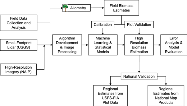
Figure 2. Method workflow for integrating local-scale field and remote sensing measurements to produce AGBD estimates and their relationship to national mapping efforts. Source: Huang et al., 2019
Data Access
These data are available through the Oak Ridge National Laboratory (ORNL) Distributed Active Archive Center (DAAC).
LiDAR Derived Biomass, Canopy Height, and Cover for New England Region, USA, 2015
Contact for Data Center Access Information:
- E-mail: uso@daac.ornl.gov
- Telephone: +1 (865) 241-3952
References
Cook, B., A. Swatantran, L. Duncanson, A. Armstrong, N. Pinto, R. Nelson. 2014. CMS: LiDAR-derived Estimates of Aboveground Biomass at Four Forested Sites, USA. ORNL DAAC, Oak Ridge, Tennessee, USA. http://dx.doi.org/10.3334/ORNLDAAC/1257
Dubayah, R.O., Swatantran A., Huang W., Duncanson L., Johnson K., Tang H., O'Neil-Dunne J., and Hurtt G.C. 2018. LiDAR Derived Biomass, Canopy Height and Cover for Tri-State (MD, PA, DE) Region, V2. ORNL DAAC, Oak Ridge, Tennessee, USA. https://doi.org/10.3334/ORNLDAAC/1538
Heath, L.S., M. Hansen, J.E. Smith, P.D. Miles, and B.W. Smith. 2008. Investigation into calculating tree biomass and carbon in the FIADB using a biomass expansion factor approach. In W. McWilliams, G.G. Moisen, andR.L. Czaplewski (Eds.), USDA Forest Service Proceedings–RMRS-P-56. USDA Forest Service.
Huang, W., K. Dolan, A. Swatantran, K. Johnson, H. Tang, J. O’Neil-Dunne, R. Dubayah, and G. Hurtt. 2019. High-resolution mapping of aboveground biomass for forest carbon monitoring system in the Tri-State region of Maryland, Pennsylvania and Delaware, USA. Environmental Research Letters 14:095002. https://doi.org/10.1088/1748-9326/ab2917
Huang, W., A. Swatantran, K. Johnson, L. Duncanson, H. Tang, J. O’Neil Dunne, G. Hurtt, and R. Dubayah. 2015. Local discrepancies in continental scale biomass maps: a case study over forested and non-forested landscapes in Maryland, USA. Carbon Balance and Management 10. https://doi.org/10.1186/s13021-015-0030-9
Kellndorfer, J., W. Walker, K. Kirsch, G. Fiske, J. Bishop, L. LaPoint, M. Hoppus, and J. Westfall. 2013. NACP Aboveground Biomass and Carbon Baseline Data, V. 2 (NBCD 2000), U.S.A., 2000. ORNL DAAC, Oak Ridge, Tennessee, U.S.A. http://dx.doi.org/10.3334/ORNLDAAC/1161
Lamb, R.L., G.C. Hurtt, T.J. Boudreau, E. Campbell, E.A. Sepúlveda Carlo, H.-H. Chu, J. de Mooy, R.O. Dubayah, D. Gonsalves, M. Guy, N.E. Hultman, S. Lehman, B. Leon, A.J. Lister, C. Lynch, L. Ma, C. Martin, N. Robbins, A. Rudee, C.E. Silva, C. Skoglund, and H. Tang. 2021. Context and future directions for integrating forest carbon into sub-national climate mitigation planning in the RGGI region of the U.S. Environmental Research Letters 16:063001. https://doi.org/10.1088/1748-9326/abe6c2
Ma, L., G. Hurtt, H. Tang, R. Lamb, E. Campbell, R. Dubayah, M. Guy, W. Huang, A. Lister, J. Lu, J. O’Neil-Dunne, A. Rudee, Q. Shen, and C. Silva. 2021. High-resolution forest carbon modelling for climate mitigation planning over the RGGI region, USA. Environmental Research Letters 16:045014. https://doi.org/10.1088/1748-9326/abe4f4
Tang, H., L. Ma, A. Lister, J. O’Neill-Dunne, J. Lu, R.L. Lamb, R. Dubayah, and G. Hurtt. 2021. High-resolution forest carbon mapping for climate mitigation baselines over the RGGI region, USA. Environmental Research Letters 16:035011. https://doi.org/10.1088/1748-9326/abd2ef
Woodall, C., L.S. Heath, G.M. Domke, and M.C. Nichols. 2011. Methods and equations for estimating aboveground volume, biomass, and carbon for trees in the US forest inventory, 2010. U.S. Department of Agriculture, Forest Service, Northern Research Station.