Documentation Revision Date: 2017-02-02
Data Set Version: V1
Summary
There are 172 files in NetCDF file format (*.nc) included in this data set. There are also 172 *.zip files included as supporting information. These zip files contain quick-look plots (48 *.png files per zip) corresponding to each netcdf file.
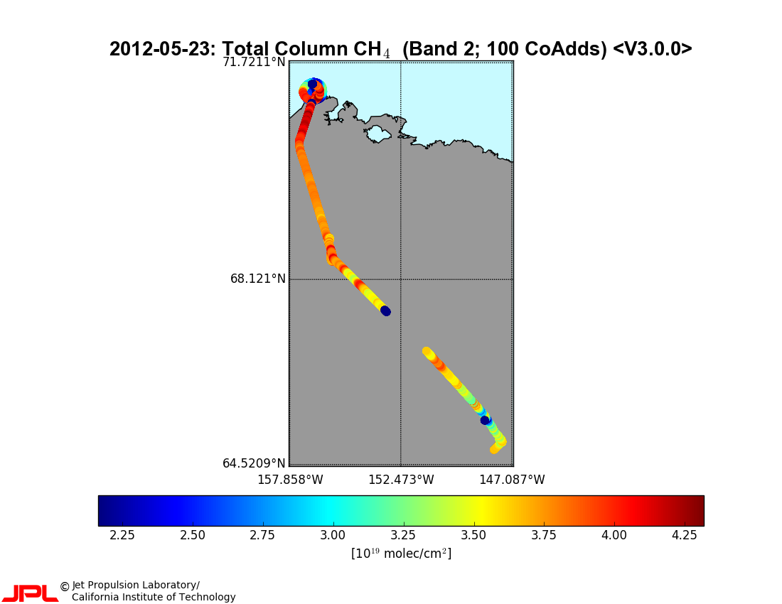
Figure 1. Total column CH4 retrievals from a CARVE flight on May 23, 2012, flying north from Fairbanks over the North Slope to Barrow.
Citation
Dupont, F., F. Tanguay, M. Li, G. Perron, C.E. Miller, S.J. Dinardo, and T.P. Kurosu. 2017. CARVE: L2 Column Gas and Uncertainty from Airborne FTS, Alaska, 2012-2015. ORNL DAAC, Oak Ridge, Tennessee, USA. http://dx.doi.org/10.3334/ORNLDAAC/1429
Table of Contents
- Data Set Overview
- Data Characteristics
- Application and Derivation
- Quality Assessment
- Data Acquisition, Materials, and Methods
- Data Access
- References
Data Set Overview
Project: Carbon in Arctic Reservoirs Vulnerability Experiment (CARVE)
The Carbon in Arctic Reservoirs Vulnerability Experiment (CARVE) is a NASA Earth Ventures (EV-1) investigation designed to quantify correlations between atmospheric and surface state variables for Alaskan terrestrial ecosystems through intensive seasonal aircraft campaigns, ground-based observations, and analysis sustained over a 5-year mission. CARVE collected detailed measurements of greenhouse gases on local to regional scales in the Alaskan Arctic and demonstrated new remote sensing and improved modeling capabilities to quantify Arctic carbon fluxes and carbon cycle-climate processes. CARVE science fills a critical gap in Earth science knowledge and satisfies high priority objectives across NASA’s Carbon Cycle and Ecosystems, Atmospheric Composition, and Climate Variability & Change focus areas as well as the Air Quality and Ecosystems elements of the Applied Sciences program. CARVE data also complements and enhances the science return from current NASA and non-NASA sensors.
Related Data:
A full list of CARVE data products is available at: https://carve.ornl.gov/dataproducts.html
Data Characteristics
Spatial Coverage: CARVE flights over the Alaskan and Canadian Arctic
Spatial Resolution: Point measurements
Temporal Coverage: 20120523 - 20151112
Temporal Resolution: The instruments were deployed on periodic flights during the growing season (approx. March - November)
Study Area (coordinates in decimal degrees)
|
Site |
Westernmost Longitude |
Easternmost Longitude |
Northernmost Latitude |
Southernmost Latitude |
|
Alaska and Canadian Arctic |
-167.646 |
-131.768 |
71.4259 |
58.8879 |
Data File Information
There are 172 files in NetCDF file format (*.nc) included in this data set. There are also 172 *.zip files included as supporting or companion files. These zip files contain quick-look plots (48 *.png per zip) corresponding to each netcdf file.
All science data are stored in NetCDF (*.nc) version 4 file format. Each file provides total vertical column measurements of CO2, CO, CH4, H2O, and O2 as well as dry air column measurements of CO2, CO, CH4, and H2O acquired during a single flight. Total vertical column is defined as vertical molecular column density integrated between surface and top-of-atmosphere at the location of the aircraft. The data product also includes geolocation information, retrieval diagnostics, and auxiliary data for improved quality control. The reported total and dry-air column values for all gases are still preliminary. They are as yet unvalidated and should be used with extreme caution in science investigations.
Missing values are set to -9.9E30.
Table 1. CARVE file naming convention. Example file name: carve_FTS_L2QR_b23_20120523_20150410124144.nc
| Name element | Example value | Units |
| Project name | carve | |
| Instrument | FTS | |
| Processing level | L2QR | |
| Build ID | b23 | |
| Flight date | 20120523 | yyyymmdd |
| Processing date and time | 20150410124144 | yyyymmddhhmmss |
Data Variables
Each file contains 5 variable groups: geolocation, science_products, retrieval_diagnostic, dads, and auxiliary_data. Each variable contains data formatted to fit one of 11 dimensions listed in Table 2. The variables contained within each variable group are described in Tables 3 to 7.
Table 2. Variable dimensions in the NetCDF files
| Dimension name | Description |
| num_times | Number of co-added observations |
| num_times_1s | Number of 1-second observations |
| num_coadd | Number of 1s spectra in each co-added observation |
| num_bands | Number of CARVE FTS bands |
| num_polarization | Number of polarization observations |
| num_vertex | Number of vertices in ground-pixel specification |
| num_instrument | Number of instruments |
| num_dads | Number of entries in DADS records |
| num_ch24 | Dimension for UTC string time fields ("24") |
| num_ch08 | Dimension for DADS time string ("8") |
| num_two | Dimension of fitting_window field ("2") |
Table 3. geolocation group variables in the NetCDF files
| Variable name | Dimension | Units | Description |
| year | num_times | n/a | Year of co-added observation |
| julian_day | num_times | n/a | Julian day of co-added observation |
| fractional_hour_of_day | num_times | n/a | Average fractional hour of day of co-added observation |
| flight_altitude | num_times | meters | Average aircraft altitude of co-added observation |
| center_latitude | num_times | degrees | Average latitude of ground pixel center of co-added observation |
| center_longitude | num_times | degrees | Average longitude of ground pixel center of co-added observation |
| solar_zenith_angle | num_times | degrees | Average solar zenith angle of co-added observation |
| solar_azimuth_angle | num_times | degrees | Average solar azimuth angle of co-added observation |
| viewing_zenith_angle | num_times | degrees | Average viewing zenith angle of co-added observation |
| viewing_azimuth_angle | num_times | degrees | Average viewing zenith angle of co-added observation |
| surface_elevation | num_times | meters | Average terrain height of co-added observation |
| time_tai93 | num_times | seconds | Average TAI93 time of co-added observation |
| time_utc | num_times*num_ch24 | n/a | UTC value of the co-added TAI93 time stamp |
| year_1s | num_times_1s | yyyy | Year of 1s observation |
| julian_day_1s | num_times_1s | n/a | Julian day of 1s observation |
| fractional_hour_of_day_1s | num_times_1s | n/a | Fractional hour of day of 1s observation |
| flight_altitude_1s | num_times_1s | meters | Aircraft altitude of 1s observation |
| center_latitude_1s | num_times_1s | degrees | Latitude of ground pixel center of 1s observation |
| center_longitude_1s | num_times_1s | degrees | Longitude of ground pixel center of 1s observation |
| solar_zenith_angle_1s | num_times_1s | degrees | Solar zenith angle of 1s observation |
| solar_azimuth_angle_1s | num_times_1s | degrees | Solar azimuth angle of 1s observation |
| viewing_zenith_angle_1s | num_times_1s | degrees | Viewing zenith angle of 1s observation |
| viewing_azimuth_angle_1s | num_times_1s | degrees | Viewing azimuth angle of 1s observation |
| surface_elevation_1s | num_times_1s | meters | Terrain height of 1s observation |
| time_tai93_1s | num_times_1s | seconds | TAI93 time of 1s observation |
| time_utc_1s | num_times_1s*num_ch24 | n/a | UTC value of the 1s TAI93 time stamp |
Table 4. science_products group variables in the NetCDF files
Note: Quality flag variables (qfl_*) indicate whether a value is missing (-1), good (0), suspect (1), or bad (2). See Table 8 for additional information.
| Variable name | Dimension | Units | Description |
| col_o2_abo2 | num_times | molec/cm2 | O2 total column (Band 1) |
| err_col_o2_abo2 | num_times | molec/cm2 | O2 total column uncertainty (Band 1) |
| qfl_col_o2_abo2 | num_times | n/a | O2 total column quality flag (Band 1) |
| col_co2_wco2 | num_times | molec/cm2 | CO2 total column (Band 2) |
| dac_co2_wco2 | num_times | ppm | XCO2 column (Band 2) |
| err_col_co2_wco2 | num_times | molec/cm2 | CO2 total column uncertainty (Band 2) |
| err_dac_co2_wco2 | num_times | ppm | XCO2 column uncertainty (Band 2) |
| qfl_col_co2_wco2 | num_times | n/a | CO2 total column quality flag (Band 2) |
| qfl_dac_co2_wco2 | num_times | n/a | XCO2 column quality flag (Band 2) |
| col_ch4_wco2 | num_times | molec/cm2 | CH4 total column (Band 2) |
| dac_ch4_wco2 | num_times | ppb | XCH4 column (Band 2) |
| err_col_ch4_wco2 | num_times | molec/cm2 | CH4 total column uncertainty (Band 2) |
| err_dac_ch4_wco2 | num_times | ppb | XCH4 column uncertainty (Band 2) |
| qfl_col_ch4_wco2 | num_times | n/a | CH4 total column quality flag (Band 2) |
| qfl_dac_ch4_wco2 | num_times | n/a | XCH4 column quality flag (Band 2) |
| col_h2o_wco2 | num_times | molec/cm2 | H2O total column (Band 2) |
| dac_h2o_wco2 | num_times | ppm | XH2O column (Band 2) |
| err_col_h2o_wco2 | num_times | molec/cm2 | H2O total column uncertainty (Band 2) |
| err_dac_h2o_wco2 | num_times | ppm | XH2O column uncertainty (Band 2) |
| qfl_col_h2o_wco2 | num_times | n/a | H2O total column quality flag (Band 2) |
| qfl_dac_h2o_wco2 | num_times | n/a | XH2O column quality flag (Band 2) |
| col_co2_sco2 | num_times | molec/cm2 | CO2 total column (Band 3) |
| dac_co2_sco2 | num_times | ppm | XCO2 column (Band 3) |
| err_col_co2_sco2 | num_times | molec/cm2 | CO2 total column uncertainty (Band 3) |
| err_dac_co2_sco2 | num_times | ppm | XCO2 column uncertainty (Band 3) |
| qfl_col_co2_sco2 | num_times | n/a | CO2 total column quality flag (Band 3) |
| qfl_dac_co2_sco2 | num_times | n/a | XCO2 column quality flag (Band 3) |
| col_ch4_sco2 | num_times | molec/cm2 | CH4 total column (Band 3) |
| dac_ch4_sco2 | num_times | ppb | XCH4 column (Band 3) |
| err_col_ch4_sco2 | num_times | molec/cm2 | CH4 total column uncertainty (Band 3) |
| err_dac_ch4_sco2 | num_times | ppb | XCH4 column uncertainty (Band 3) |
| qfl_col_ch4_sco2 | num_times | n/a | CH4 total column quality flag (Band 3) |
| qfl_dac_ch4_sco2 | num_times | n/a | XCH4 column quality flag (Band 3) |
| col_h2o_sco2 | num_times | molec/cm2 | H2O total column (Band 3) |
| dac_h2o_sco2 | num_times | ppm | XH2O column (Band 3) |
| err_col_h2o_sco2 | num_times | molec/cm2 | H2O total column uncertainty (Band 3) |
| err_dac_h2o_sco2 | num_times | ppm | XH2O column uncertainty (Band 3) |
| qfl_col_h2o_sco2 | num_times | n/a | H2O total column quality flag (Band 3) |
| qfl_dac_h2o_sco2 | num_times | n/a | XH2O column quality flag (Band 3) |
| col_co_sco2 | num_times | molec/cm2 | CO total column (Band 3) |
| dac_co_sco2 | num_times | ppb | XCO column (Band 3) |
| err_col_co_sco2 | num_times | molec/cm2 | CO total column uncertainty (Band 3) |
| err_dac_co_sco2 | num_times | ppb | XCO column uncertainty (Band 3) |
| qfl_col_co_sco2 | num_times | n/a | CO total column quality flag (Band 3) |
| qfl_dac_co_sco2 | num_times | n/a | XCO column quality flag (Band 3) |
Tables 5a & 5b. retrieval_diagnostic group sub-groups and variables in the NetCDF files
Table 5a. Sub-groups
Note: Retrieval diagnostics layers are provided for multiple gases and derivation bands. CO2 and CH4 are being derived independently from two different bands of the CARVE FTS- Band 2, the weak CO2 band (wco2) around 1.6 μm, and Band 3, the strong CO2 band (sco2) around 2.3 μm. For symmetry, data fields related to O2, which is observed oxygen A band, have been appended with “abo2”.
| Sub-group name | Description |
| o2_abo2 | Retrieval parameters for O2 fitting (Band 1) |
| co2_wco2 | Retrieval parameters for CO2 fitting (Band 2) |
| ch4_wco2 | Retrieval parameters for CH4 fitting (Band 2) |
| h2o_wco2 | Retrieval parameters for H2O fitting (Band 2) |
| co2_sco2 | Retrieval parameters for CO2 fitting (Band 3) |
| ch4_sco2 | Retrieval parameters for CH4 fitting (Band 3) |
| h2o_sco2 | Retrieval parameters for H2O fitting (Band 3) |
| co_sco2 | Retrieval parameters for CO fitting (Band 3) |
Table 5b. Variables
Note: “<gas>” indicates any gaseous absorber considered during the retrieval. While retrievals in the O2 A band include only O2 as an absorber, the other gas retrievals include multiple absorbers for the following list: CO2, CH4, H2O, HDO, and CO. For details consult the variable entries in the particular sub-groups.
| Variable name | Dimension | Units | Description |
| fitting_window | num_two | cm-1 | Fitting window limits |
| baseline_polynomial | scalar | n/a | Order of fitted baseline Legendre polynomial |
| nit | num_times | n/a | Number of iterations |
| cl | num_times | native | Continuum level |
| ct | num_times | n/a | Continuum tilt |
| cc | num_times | 0.075% p/p | Continuum curvature |
| fs | num_times | mK | Frequency shift |
| s_m_g | num_times | ppm | “Solar minus gas” shift |
| zo | num_times | % | Zero-level offset of continuum |
| zpres | num_times | Km | Surface pressure altitude |
| rms_o_cl | num_times | n/a | RMS nose / cl |
| am_<gas> | num_times | n/a | Air mass factor for <gas> |
| ovc_<gas> | num_times | molec/cm2 | Original vertical column for <gas> |
| vsf_<gas> | num_times | n/a | Vertical scale factor for <gas> |
| vsf_<gas>_error | num_times | n/a | VSF total error for <gas> |
Table 6. dads group variables in the NetCDF files
| Variable name | Dimension | Units | Description |
| gps_alt | num_dads | m | Aircraft GPS altitude |
| gps_lat | num_dads | deg | Aircraft GPS latitude |
| gps_lon | num_dads | deg | Aircraft GPS longitude |
| gps_time | num_dads×num_ch08 | n/a | GPS time (8 character UTC time string) |
| heading | num_dads | deg | Aircraft heading |
| pitch | num_dads | deg | Aircraft pitch |
| roll | num_dads | deg | Aircraft roll |
Table 7. auxiliary_data group variables in NetCDF files
| Variable name | Dimension | Units | Description |
| spectrum_signal | num_times×num_bands | n/a | Spectral signal of co-added data, by band |
| spectrum_noise | num_times×num_bands | n/a | Spectral noise of co-added data, by band |
| spectrum_snr | num_times×num_bands | n/a | SNR of co-added data, by band |
| spectrum_signal_1s | num_times_1s×num_bands | n/a | Spectral signal of 1s data, by band |
| spectrum_noise_1s | num_times_1s×num_bands | n/a | Spectral noise of 1s data, by band |
| spectrum_snr_1s | num_times_1s×num_bands | n/a | SNR of 1s data, by band |
| num_coadded_spectra | num_times | n/a | Number of 1s spectra in each co-added observation |
| idx_coadded_spectra | num_times×num_coadd | n/a | Index values of the num_coadded_spectra 1s spectra used in each co-added observation |
Companion files:
There are 172 *.zip files, with one file corresponding to each netcdf file, included with this data set as supporting information. These zip files follow the same file-naming convention as the netcdf data. The zip files contain quick-look plots (48 *.png per zip) plus a readme file explaining the png data plots. The image in Figure 1 is an example of a quick-look plot for the flight on 20120523.
Application and Derivation
The carbon budget of Arctic ecosystems is not known with confidence because fundamental elements of this complex system are poorly quantified. The CARVE project was designed to collect detailed measurements of important greenhouse gases on local to regional scales in the Alaskan Arctic and demonstrate new remote sensing and improved modeling capabilities to quantify Arctic carbon fluxes and carbon cycle-climate processes. The CARVE data provide insights into carbon cycling that may be useful in numerous applications.
Quality Assessment
Each NetCDF file contains a global attribute MasterQualityFlag that provides a summary indication of the data quality level of the whole file. Its values are set to either good or suspect. Error estimates for total column and dry-air column computations are detailed further in Section 5 below. Global attributes PercentBadObservations, PercentGoodObservations, PercentMissingObservations, and PercentSuspectObservations indicate the percentage of data for which each quality flag is assigned.
In addition, each data product – either total or dry-air column – has a quality flag associated with it. This flag consists of an integer number for each reported observation (Table 8). The assessment of quality status is currently based on instrument signal-to-noise-ratio (SNR), absolute column value, relative fitting uncertainty of the retrieved total columns, and absolute values of the CO2 and CH4 dry-air columns:
i. Spectra with low SNR generally produce noisy, i.e., highly uncertain retrievals. Thus, FTS SNR values are used to screen for low-signal values. Any measurement below the minimum threshold - currently set to 20 - is flagged as bad. Since the FTS is not yet radiometrically calibrated, the SNR are used as proxy for scene illumination and overall radiometric information content.
ii. Negative values for total columns are bad. Thresholds for relative fitting uncertainty are listed in Table 9.
iii. Relative fitting uncertainty is used to distinguish suspect from good retrievals. For each product, relative fitting uncertainty is checked against a pre-set maximum. If the threshold is exceeded, the corresponding total column value is flagged suspect.
iv. For quality assurance purposes, the physically acceptable range of XCO2 is considered 370-430 ppm, and that of XCH4 1700-2200 ppb. Values outside those ranges are considered suspect. Similar assessments are not performed for XCO and XH2O, due to the highly variable nature of those species.
Dry-air column products inherit the lowest-quality flag from the total column values that go into their computation. If at least one of the total columns is flagged suspect or bad, the resulting dry-air column will be flagged suspect or bad by default.
Table 8. Summary of quality assessment and product quality flags
| QC Flag | Flag Meaning | Description |
| -1 | missing | No column values have been computed; entries are missing |
| 0 | good | Total or dry-air column value present and passes all quality checks |
| 1 | suspect | Caution advised because one or more of the following conditions are present:
Total columns:
|
| 2 | bad | Avoid using data because one or more of the following conditions are present:
|
Table 9. Relative fitting uncertainties for total column products
| Product | O2 (Band 1) | CO2 (Band 2) | CH4 (Band 2) | H2O (Band 2) | CO2 (Band 3) | CH4 (Band 3) | H2O (Band 3) | CO (Band 3) |
| Threshold | 6% | 2% | 2% | 2% | 5% | 5% | 5% | 30% |
Data Acquisition, Materials, and Methods
CARVE Flights
These data represent one part of the data collected by the Carbon in Arctic Reservoirs Vulnerability Experiment. A C-23 Sherpa aircraft made frequent flights out of Fairbanks, Alaska between March and November over multiple years, observing the spring thaw, summer draw-down, and fall refreeze of the Arctic growing season. Flights concentrate observations on three study domains: the North Slope, the interior, and the Yukon River valley. North Slope flights cover regions of tundra and continuous permafrost and were anchored by flux towers in Barrow, Atqasuk, and Ivotuk. Flights to Prudhoe Bay characterize the CO2 and CH4 emissions from oil and natural gas processing plants. Flights over interior Alaska sample discontinuous permafrost, boreal forests, and wetlands. A complete list of CARVE flights can be found at: https://carve.ornl.gov/flights.html. Flight paths and atmospheric gas concentrations for CARVE surveys can be visualized through the CARVE Flight Data Visualization Tool (http://carve.ornl.gov/visualize) and are illustrated in Figure 2.
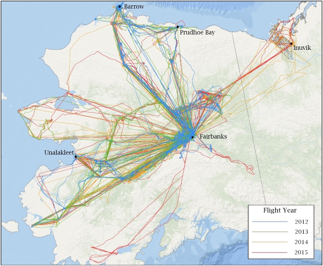
Figure 2. CARVE flights during 2012-2015 delivered measurements over continuous and discontinuous permafrost regimes.
The CARVE aircraft carried a remote sensing and atmospheric sampling payload consisting of the following instruments: a Fourier transform spectrometer (FTS), and an in situ gas analyzer suite (ISGA) with a gas analyzer and PFP sampling system (see https://carve.ornl.gov/documentation.html). All instruments were controlled by a master computer system (Data Acquisition and Distribution System, DADS). Data were logged and UTC time stamped at 1 second intervals. DADS also recorded GPS data (Lat, Lon, elevation), aircraft pitch, roll, and yaw, as well as basic meteorological data from onboard instruments.
Fourier Transform Spectrometer
The CARVE Fourier Transform Spectrometer (FTS; Figure 2) consists of three near-IR channels with spectral ranges of 12,920 – 13,180 cm-1 (Band 1), 5,820 – 6,380 cm-1 (Band 2), and 4,200 – 4,322 cm-1 (Band 3). Each band has a spectral resolution of 0.2 cm-1. The instrument can be operated in polarization mode, where each band records the S- and P-polarization components separately, or un-polarized. During 2012, the first year of operations, the FTS observed in polarization mode. In 2013, prompted by the challenging observation conditions in the Alaskan Arctic, the instrument configuration was changed to un-polarized in order to improve signal-to-noise ratios.
The FTS Level 2 products are derived from all three bands: Band 1 provides the O2 observations that are used in the computation of dry-air columns, as well as fluorescence (not part of the current release); Band 2 is used for retrievals of CO2, CH4, and H2O; and Band 3 is used for observations of CO, as well as a second set of products for CO2 and CH4.
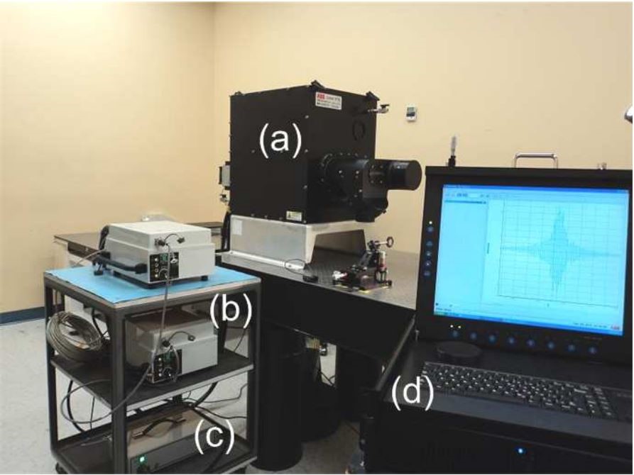
Figure 3. CARVE-FTS system: (a) instrument, (b) control electronic boxes, (c) power supply, and (d) interface control computer. Figure from Dupont et al., 2012.
The CARVE aircraft takes FTS nadir measurements in 1-second intervals along the flight track, corresponding roughly to a displacement of 100 m on the ground. For the retrievals, up to 100 of these 1-second observations are co-added to a single spectrum, corresponding to roughly 10 km along flight track. Pre-retrieval co-adding improves signal-to-noise ratio (SNR) of the observations and provides greatly improved uncertainties in the retrieved column values. Not necessarily all 100 spectra (per FTS band) with the 100-second co-adding interval are being used in the final, co-added spectrum. Rather, the selection is based on whether the specific set of three spectra – one from each of the three FTS bands – improves overall SNRs across the bands. If one or more of the three spectra significantly degrades the over SNR, the whole set is rejected. This ensures that (a) low SNR observations are discarded, and that (b) exactly the same set of 1-second observations is used in the 100-second co-added spectra for each band. The latter is important because dry-air columns are derived from ratios of retrievals performed in different bands, using different sets of 1 second spectra in each band for the same co-added observation would introduce a random source of error.
The CARVE FTS has a 10 degree field of view, which makes across-track coverage dependent on flight altitude. The current release of the FTS Level 2 data products do not contain information on ground footprint. A data field with this information will be added to future releases.
Both CO2 and CH4 are being derived independently from two different bands of the CARVE FTS – Band 2, also referred to as the weak CO2 band (wco2) around 1.6 μm, and Band 3, the strong CO2 band (sco2) around 2.3 μm. The field names in the data file have been appended with “wco2” and “sco2” in order to distinguish the same molecule product derived from bands 2 and 3. This has been done even in the cases of CO and H2O, where no ambiguity exists. For symmetry, data fields related to O2, which is observed in the oxygen A band, have been appended with “abo2”.
Several fields in the geolocation and auxiliary_data groups come in two sets, one of which contains “1s” at the end of the field names. These are the 1-second interval data mentioned above. They have been included in the data product for diagnostic purposes. Particularly the information on surface elevation at 1s temporal resolution (in geolocation), together with the list of 1s observations that went into each co-added retrieval (idx_coadded_spectra in the auxiliary_data group) may be helpful for enhanced quality assessment. The dads group contains latitude, longitude, and flight altitude information for the entire time the CARVE computer system on-board the aircraft was switched on. This includes the taxiing periods prior to take-off and after touch-down. While the variables in the geolocation group only provide information for periods when the FTS was in operation, the dads variables cover the full extent of the flight.
Retrieval and Total Column/Dry-Air Column Computations
Column retrievals are based on the TCCON GGG/GFit algorithm (TCCON, CalTech). GFit was developed to evaluate ground-based FTS direct sun observations. The algorithm was modified to include the atmospheric column below the aircraft in order to work with the CARVE flight measurements. GFIT uses a single atmospheric vertical profile scaled to match the absorbed radiances for each target gas. The algorithm returns a scaling factor as well as its error estimate for each trace gas profile included in the retrieval, plus values for spectral shift, continuum offset and curvature, and other auxiliary parameters fitted to the observed radiances.
Total column computation
Total column values for each gas are the product of the original column value reported by GFit and the retrieved scaling factor. Total column uncertainties are the product of the total column value and the algorithm error estimate.
Dry-air column computation
The computation of dry-air columns (XCO2, XCH4, XCO, XH2O) makes use of the constant volume mixing ratio of O2 throughout most of the atmosphere. The dry-air column for gas G (XG) is computed from the observed total columns of the gas (TG) and that of O2 (TO2) as follows:
XG = ( TG / TO2 ) * 0.2095
which is then scaled by an additional factor depending on whether XG is reported in ppm or ppb.
The uncertainty of the dry-air columns dXG is computed from the relative root-sum-square total column errors of TG and TO2:
dXG = XG * [ ( dTG / TG )2 + ( dTO2 / TO2 )2 ]1/2
Note: Error estimates reported in the product for total and dry air columns are solely based on the algorithm retrieval error. They underestimate the true error, since error sources like scene inhomogeneity and line spectroscopy have not been considered.
Data Access
These data are available through the Oak Ridge National Laboratory (ORNL) Distributed Active Archive Center (DAAC).
CARVE: L2 Column Gas and Uncertainty from Airborne FTS, Alaska, 2012-2015
Contact for Data Center Access Information:
- E-mail: uso@daac.ornl.gov
- Telephone: +1 (865) 241-3952
References
Dupont, F., F. Tanguay, M. Li, G. Perron, C.E. Miller, S.J. Dinardo, and T.P. Kurosu (2012). CARVE-FTS Observations of Arctic CO2, CH4, and CO - Overview of the Instrument, Proc. Of SPIE, 8532, 853204. http:dx.doi.org/10.1117/12.979826
TCCON, Caltech. TCCON GGG/GFit algorithm. https://tccon-wiki.caltech.edu/Software/GGG. An account and password is required to access the information on the TCCON Wiki. Please consult the Wiki home page for contact information: https://tccon-wiki.caltech.edu/
Wunch, D., G.C. Toon, V. Sherlock, N.M. Deutscher, X. Liu, D.G. Feist, and P.O. Wennberg. The Total Carbon Column Observing Network's GGG2014 Data Version. 2015. Carbon Dioxide Information Analysis Center, Oak Ridge National Laboratory, Oak Ridge, Tennessee, U.S.A. http://dx.doi.org/10.14291/tccon.ggg2014.documentation.R0/1221662