Documentation Revision Date: 2022-01-27
Dataset Version: 1.1
Summary
There are 139 data files included in this dataset, including 120 files in ICARTT (*.ict) format and 19 files in *.rtso format. There are also five companion files, including four files in Portable Document Format (*.pdf) format and one file in Interactive Data Language (IDL) named program file (*.pro) format.
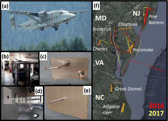
Figure 1. The CARAFE payload. (a) The NASA C-23 Sherpa. (b) A view inside the cabin with all instruments installed. (c) The angle-of-attack (upper) and total air temperature (lower) probes. (d) The DLH window plate (upper left) and fairing-mounted target (lower right). (e) GHG inlet. (f) Flux leg flight tracks for both campaigns.
Citation
Wolfe, G.M., S.R. Kawa, T.F. Hanisco, R.A. Hannun, P.A. Newman, A.K. Swanson, S.A. Bailey, J.D. Barrick, K.L. Thornhill, G.S. Diskin, J.P. DiGangi, J.B. Nowak, C.E. Sorensen, G.L. Bland, J.K. Yungel, and C.A. Swenson. 2021. CARAFE: Regional Airborne Greenhouse Gases Eddy Covariance Measurements, 2016-2017. ORNL DAAC, Oak Ridge, Tennessee, USA. https://doi.org/10.3334/ORNLDAAC/2002
Table of Contents
- Dataset Overview
- Data Characteristics
- Application and Derivation
- Quality Assessment
- Data Acquisition, Materials, and Methods
- Data Access
- References
- Dataset Revisions
Dataset Overview
This dataset provides airborne eddy covariance (EC) fluxes of carbon dioxide, methane, sensible heat, and latent heat at high spatial resolution collected during the NASA Carbon Airborne Flux Experiment (CARAFE) airborne 2016 and 2017 campaigns. CARAFE utilized the NASA C-23 Sherpa aircraft with a suite of commercial and custom instrumentation. Deployment occurred across the Mid-Atlantic Region for the period 2016-09-07 through 2016-09-26 and 2017-05-03 through 2017-05-26. The data also include downwelling radiation, water vapor, pressure, temperature, wind, and aircraft navigation data. Airborne EC can quantify surface fluxes at local to regional scales, potentially helping to bridge gaps between top-down and bottom-up flux estimates and offering novel insights into biophysical and biogeochemical processes.
Project: CARbon Airborne Flux Experiment
The NASA CARbon Airborne Flux Experiment (CARAFE) utilized the NASA C-23 Sherpa aircraft with a suite of commercial and custom instrumentation to acquire fluxes of carbon dioxide, methane, sensible heat, and latent heat at high spatial resolution. Continuous wavelet transforms deliver spatially resolved fluxes along aircraft flight tracks. Typical uncertainties in derived surface fluxes are 40–90% for a nominal resolution of 2 km or 16–35% when averaged over a full leg (typically 30–40 km). CARAFE had successfully flown two campaigns in the eastern US in 2016 and 2017, quantifying fluxes over forest, cropland, wetlands, and water.
Related Datasets
Wolfe, G.M., S.R. Kawa, T.F. Hanisco, R.A. Hannun, P.A. Newman, A.K. Swanson, S.A. Bailey, J.D. Barrick, K.L. Thornhill, G.S. Diskin, J.P. DiGangi, J.B. Nowak, C.E. Sorensen, G.L. Bland, J.K. Yungel, and C.A. Swenson. 2021. CARAFE: Regional Airborne Greenhouse Gases Eddy Covariance Measurements, 2016-2017. ORNL DAAC, Oak Ridge, Tennessee, USA. https://doi.org/10.3334/ORNLDAAC/1886
- Initial release of the dataset, which includes all files available at the NASA LaRC mission page for CARAFE (https://www-air.larc.nasa.gov/missions/carafe/). Now superseded by version 1.1 (current dataset) and available only upon request.
Related Publication
Wolfe, G.M., S.R. Kawa, T.F. Hanisco, R.A. Hannun, P.A. Newman, A. Swanson, S. Bailey, J. Barrick, K.L. Thornhill, G. Diskin, J. DiGangi, J.B. Nowak, C. Sorenson, G. Bland, J.K. Yungel, and C.A. Swenson. 2018. The NASA Carbon Airborne Flux Experiment (CARAFE): instrumentation and methodology. Atmospheric Measurement Techniques 11:1757–1776. https://doi.org/10.5194/amt-11-1757-2018
Acknowledgments
The CARAFE 2016 and 2017 missions were supported by NASA Goddard Space Flight Center's Internal Research and Development, the NASA Carbon Monitoring System Program (NNH15ZDA001N-CMS), and the NASA HQ Earth Science Division.
Data Characteristics
Spatial Coverage: Mid-Atlantic U.S.
Spatial Resolution: Points
Temporal Coverage: 9 days (07, 09, 12, 14, 16, 22, 23, 24, and 26) in September 2016 and 10 days (03, 04, 08, 09, 10, 15, 16, 18, 19, and 26) in May 2017
Temporal Resolution: Seconds
Study Area: Latitude and longitude are given in decimal degrees.
| Site | Northernmost Latitude | Southernmost Latitude | Easternmost Longitude | Westernmost Longitude |
|---|---|---|---|---|
| Mid-Atlantic U.S. | 41.11453923 | 35.17605461 | -73.564453 | -79.89257812 |
Data File Information
There are 139 data files included in this dataset, including 120 files in ICARTT (*.ict) format and 19 files in *.rtso format. There are also five companion files, including four files in Portable Document Format (*.pdf) format and one file in IDL named program file (*.pro) format.
Generally, the data files are named CARAFE-<dataID>_SHERPA_<date>_<revision>_<launch>_<comments>.<extension>, where
- <dataID> = short description of measured parameter/species, instrument, or model preceded by the mission name "CARAFE-" (DLH, FLUX, GHG-1Hz, GHG-10Hz, MET, or WINDS)
- <locationID> = short description of site, station, platform, laboratory, or institute (SHERPA or SONDES)
- <date> = four-digit year (2016 or 2017), two-digit month (05 or 09), two-digit day; the date always refers to the UTC date of launch
- <revision> = revision number of data (e.g., R0, R1)
- <launch> = optional launch number (L1, L2)
- <comments> = optional additional information (10Hz, or 20Hz)
- <extension> = file extension (*.ict or *.rtso)
Table 1. File names and descriptions.
| File Names | Number of Files | Description |
|---|---|---|
| Data Files | ||
| CARAFE-DLH_SHERPA_<date>_<revision>_<launch>_<comments>.ict | 40 | Water vapor mixing ratio and relative humidity data collected with a Diode Laser Hygrometer (DLH). There are two files for each date, one sampled at 1 Hz and another sampled at 20 Hz (includes "20Hz" in the filename). |
| CARAFE-FLUX_SHERPA_<date>_<revision>_<launch>.ict | 20 | CO2 flux, CH4 flux, and flux error data. |
| CARAFE-GHG-1Hz_SHERPA_<date>_<revision>_<launch>.ict | 20 | Greenhouse gas suite including CO2, CH4, H2O dry mole fractions sampled at 1 Hz. |
| CARAFE-GHG-10Hz_SHERPA_<date>_<revision>_<launch>.ict | 20 | Greenhouse gas suite including CO2, CH4, H2O dry mole fractions sampled at 10 Hz. |
| CARAFE-MET_SONDES_<date>_R0.rtso | 19 | Raw radiosonde data. There is one file for each of the dates for 2016 (9 files) and 2017 (10 files). The companion file IDL_reader_for_sondes_rtso_files.pro is provided for data access using IDL software. These files can also be opened in generic text software. |
| CARAFE-WINDS_SHERPA_<date>_<revision>_<launch>.ict | 20 | Fast, in-situ 3-D wind data. Note that the WINDS data files also contain important navigational and environmental variables, including aircraft position (latitude, longitude, and altitude), aircraft attitude (pitch, roll, and heading), speed, static pressure, and temperature. |
| Companion Files | ||
| CARAFE_2016_2017_v1.1_variables.pdf | 1 | Variable names and descriptions for all data files. |
| CARAFE_Flight_Reports_2016.pdf | 1 | Flight details for the 2016 campaign. |
| CARAFE_Flight_Reports_2017.pdf | 1 | Flight details for the 2017 campaign. |
| IDL_reader_for_sondes_rtso_files.pro | 1 | An Interactive Data Language (IDL) file for visualization of the sondes data. |
Data File Details
The Coordinate Reference System is “WGS 84” (EPSG:4326).
Variable names and descriptions for all data files are available in the companion file CARAFE_2016_2017_v1.1_variables.pdf.
Application and Derivation
Measurements acquired from this mission were designed to help answer several science questions:
- How does land-air exchange of CO2 and CH4 respond to climate-induced stresses (e.g., heat, drought, pests)?
- How do energy production (e.g., oil/gas, corn ethanol) and agricultural activities impact greenhouse gas inventories?
These data could be useful to climate change studies (Hannun et al., 2020). The exchange of trace gases between the Earth’s surface and atmosphere strongly influences atmospheric composition. Airborne eddy covariance (EC) can quantify surface fluxes at local to regional scales (1–1000 km), potentially helping to bridge gaps between top-down and bottom-up flux estimates and offering novel insights into biophysical and biogeochemical processes.
Quality Assessment
All uncertainties are provided as explicit variables or in the headers and are reported for each sampling interval. Uncertainty in EC fluxes arises from measurement limitations, sampling strategies, and the fundamental nature of turbulence. When extrapolating airborne fluxes to the surface, uncertainties in vertical flux divergence must also be considered. Fluxes of CH4 were negligibly small for most of the mission, thus the fractional errors are biased high. When flying over methane source regions (e.g., wetlands), CH4 flux errors are comparable to those in CO2 flux.
The quality of the 3-D wind measurement hinges on the performance of the differential pressure measurements. Uncertainty information is also provided as notes in the companion file CARAFE_Fall_2016_2017_v1.1_variables.pdf.
Water vapor data are averaged to 20 Hz with a typical precision (1σ) of 0.3% or better. Overall measurement accuracy was within 5%, based on field inter-comparisons on other airborne platforms (Jensen et al., 2017; Rollins et al., 2014).
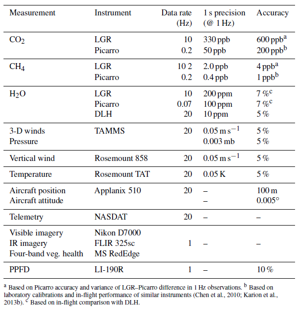
Table 2. Instrument specifications for the CARAFE payload. Source: Wolfe et al. (2018)
Data Acquisition, Materials, and Methods
Overview
The NASA CARAFE mission utilized the NASA C-23 Sherpa aircraft with a suite of commercial and custom instrumentation to acquire fluxes of carbon dioxide, methane, sensible heat, and latent heat at high spatial resolution. Key components of the CARAFE payload (Table 2) include meteorological, greenhouse gas, water vapor, and surface imaging systems. Continuous wavelet transforms delivered spatially resolved fluxes along aircraft flight tracks.
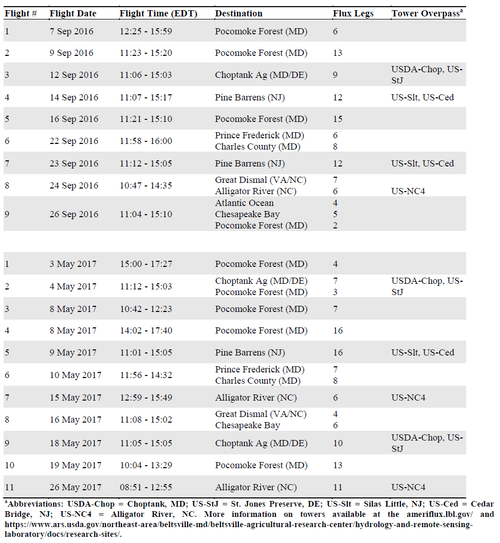
Deployment occurred across the Mid-Atlantic Region for the period 2016-09-07 through 2016-09-26 and 2017-05-03 through 2017-05-26 (Table 3). In particular, flights occurred over the Pocomoke Forest area on the Eastern Shore of Maryland; agricultural areas and tidal marshlands from the Eastern Shore of Virginia to southern Delaware; southern Maryland; the Chesapeake Bay and the Atlantic Ocean; the New Jersey Pine Barrens in the southern portion of the state; and the Alligator River and the Great Dismal Swamp in eastern North Carolina and southeastern Virginia.
Table 3. Dates and locations of CARAFE deployments
The scientific objectives of CARAFE were to:
- Observe and quantify fluxes of carbon dioxide, methane, sensible heat, and latent heat at a high spatial resolution over a spectrum of ecosystems,
- Assemble a versatile, economical system for measuring airborne fluxes,
- Evaluate biophysical process models and parameterizations, and
- Validate satellite flux products from OCO-2 and other missions.
Meteorology & Telemetry
Meteorology and telemetry measurements were made using the Sherpa Turbulent Air Motion and Meteorology System (TAMMS), a suite of sensors for high-frequency measurement of horizontal and vertical wind vectors, pressure, and temperature. Winds were derived from five pitot static-pressure ports mounted on the radome (nose) of the aircraft (Brown et al., 1983; Thornhill et al., 2003). In essence, these sensors provide the velocity of air with respect to the aircraft. Combining this information with a high-quality GPS and Inertial Navigation System (Applanix 510) yielded the velocity of air with respect to the Earth’s surface. A hatch on the forward left side supported a Rosemount model 858 angle-of-attack probe for redundant vertical wind measurements and a Rosemount model 102 non-deiced total air temperature sensor housing coupled with a platinum sensing element (E102E4AL; Stickney et al., 1990) for fast (8 Hz) air temperature measurement. A NASA Airborne Science Data and Telemetry (NASDAT) system recorded data from the sensors at 20 Hz.
Water Vapor
The NASA Langley Diode Laser Hygrometer (DLH; Diskin et al., 2002), is an open-path infrared absorption spectrometer that uses a variation of wavelength modulation spectroscopy (Silver, 1992) to measure water vapor mole fraction. Data were processed at the instrument’s native 100 Hz acquisition rate.
Greenhouse Gas Suite
The greenhouse gas (GHG) suite consisted of several modified commercial analyzers coupled with custom hardware for fast gas flow and centralized data acquisition. Two Los Gatos Research (LGR) analyzers, one for CO2 (model no. 907-0020-1000) and the other for CH4 and water vapor (model no. 913-0014-0001), acquired mixing ratios at 10 Hz. A Picarro G1301-m analyzer supplies an additional set of CO2/CH4/H2O mixing ratios. Compared to the LGR analyzers, the Picarro provided reduced-duty precision and stability. Thus, the LGR systems provided fast measurements needed for EC flux calculations while the Picarro served as an accuracy standard. For the 2016 deployment, a Picarro G2401-m replaced the G1301-m for the last four flights following a power supply failure on the latter. Data streams from all analyzers, along with a GPS feed, were recorded via RS232 using a National Instruments Compact RIO controller.
Refer to Wolfe et al. (2018) for additional information.
Data Access
These data are available through the Oak Ridge National Laboratory (ORNL) Distributed Active Archive Center (DAAC).
CARAFE: Regional Airborne Greenhouse Gases Eddy Covariance Measurements, 2016-2017
Contact for Data Center Access Information:
- E-mail: uso@daac.ornl.gov
- Telephone: +1 (865) 241-3952
References
Brown, E.N., C.A. Friehe, and D.H. Lenschow. 1983. The use of pressure fluctuations on the nose of an aircraft for measuring air motion. Journal of Climate and Applied Meteorology 22:171–180. https://doi.org/10.1175/1520-0450(1983)022<0171:TUOPFO>2.0.CO;2
Diskin, G.S., J.R. Podolske, G.W. Sachse, and T.A. Slate. 2002. Open-path airborne tunable diode laser hygrometer. Proc. SPIE 4817, Diode Lasers and Applications in Atmospheric Sensing, (23 September 2002). https://doi.org/10.1117/12.453736
Hannun, R.A., G.M. Wolfe, S.R. Kawa, T.F. Hanisco, P.A. Newman, J.G. Alfieri, J. Barrick, K.L. Clark, J.P. DiGangi, G.S. Diskin, J. King, W.P. Kustas, B. Mitra, A. Noormets, J.B. Nowak, K.L. Thornhill, and R. Varga. 2020. Spatial heterogeneity in CO2, CH4, and energy fluxes: insights from airborne eddy covariance measurements over the Mid-Atlantic region. Environmental Research Letters 15:035008. https://doi.org/10.1088/1748-9326/ab7391
Jensen, E.J., L. Pfister, D.E. Jordan, T.V. Bui, R. Ueyama, H.B. Singh, T.D. Thornberry, A.W. Rollins, R.-S. Gao, D.W. Fahey, K.H. Rosenlof, J.W. Elkins, G.S. Diskin, J.P. DiGangi, R.P. Lawson, S. Woods, E.L. Atlas, M.A. Navarro Rodriguez, S.C. Wofsy, J. Pittman, C.G. Bardeen, O.B. Toon, B.C. Kindel, P.A. Newman, M.J. McGill, D.L. Hlavka, L.R. Lait, M.R. Schoeberl, J.W. Bergman, H.B. Selkirk, M.J. Alexander, J.-E. Kim, B.H. Lim, J. Stutz, and K. Pfeilsticker. 2017. The NASA Airborne Tropical Tropopause Experiment: High-Altitude Aircraft Measurements in the Tropical Western Pacific. Bulletin of the American Meteorological Society 98:129–143. https://doi.org/10.1175/BAMS-D-14-00263.1
Rollins, A.W., T.D. Thornberry, R.S. Gao, J.B. Smith, D.S. Sayres, M.R. Sargent, C. Schiller, M. Krämer, N. Spelten, D.F. Hurst, A.F. Jordan, E.G. Hall, H. Vömel, G.S. Diskin, J.R. Podolske, L.E. Christensen, K.H. Rosenlof, E.J. Jensen, and D.W. Fahey. 2014. Evaluation of UT/LS hygrometer accuracy by intercomparison during the NASA MACPEX mission. Journal of Geophysical Research: Atmospheres 119:1915–1935. https://doi.org/10.1002/2013JD020817
Silver, J.A. 1992. Frequency-modulation spectroscopy for trace species detection: theory and comparison among experimental methods. Applied Optics 31:707. https://doi.org/10.1364/AO.31.000707
Stickney, T.M., M.W. Shedlov, and D.I. Thompson. 1990. Rosemount Total Temperature Sensors, Tech. Rep. 5755, Rev. B., Rosemount, Inc., Burnsville, MN, USA.
Thornhill, K.L., B.E. Anderson, J.D.W. Barrick, D.R. Bagwell, R. Friesen, and D.H. Lenschow. 2003. Air motion intercomparison flights during transport and chemical evolution in the Pacific (TRACE-P)/ACE-ASIA. Journal of Geophysical Research 108:9001. https://doi.org/10.1029/2002jd003108
Wolfe, G.M., S.R. Kawa, T.F. Hanisco, R.A. Hannun, P.A. Newman, A. Swanson, S. Bailey, J. Barrick, K.L. Thornhill, G. Diskin, J. DiGangi, J.B. Nowak, C. Sorenson, G. Bland, J.K. Yungel, and C.A. Swenson. 2018. The NASA Carbon Airborne Flux Experiment (CARAFE): instrumentation and methodology. Atmospheric Measurement Techniques 11:1757–1776. https://doi.org/10.5194/amt-11-1757-2018
Dataset Revisions
| Version | Release Date | Revision Notes |
|---|---|---|
| 1.1 | 2021-01-28 | Excludes data that were considered preliminary (i.e., revision number "RA" or "RB"): CO-N2O, VWINDS, Hskping, mrg01-SHERPA, and mrg60-SHERPA. Other data remain the same as in Version 1.0. |
| 1.0 | 2021-09-20 | Initial release of the dataset. Includes all files available at the NASA LaRC mission page fo CARAFE (https://www-air.larc.nasa.gov/missions/carafe/). Superseded by Version 1.1 and available only upon request. |