Documentation Revision Date: 2018-09-18
Data Set Version: 1
Summary
This dataset contains one data file in csv format.
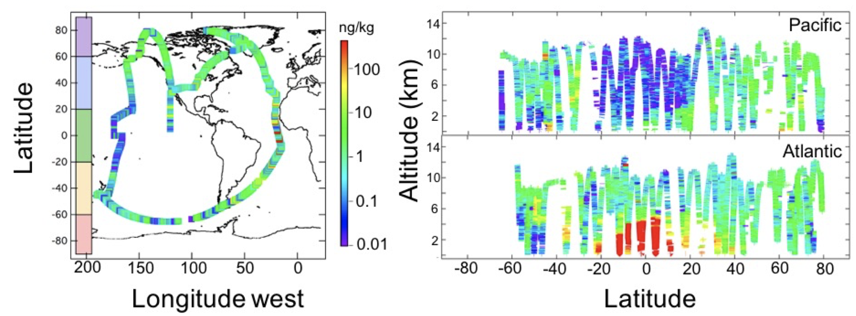
Figure 1: Left: Flight tracks (colored line) of the NASA DC-8 during the ATom-1 deployment. Right: Altitude vs latitude for the Pacific (top) and Atlantic (bottom) basins. Color in both figures represents black carbon mass-mixing ratio in units of ng rBC/kg of air.
Citation
Katich, J.M., J.P. Schwarz, K. Froyd, B. Weinzierl, M. Dollner, T.P. Bui, C.S. Chang, and J.M. Dean-Day. 2018. ATom: Black Carbon Mass Mixing Ratios from ATom-1 Flights. ORNL DAAC, Oak Ridge, Tennessee, USA. https://doi.org/10.3334/ORNLDAAC/1618
Table of Contents
- Data Set Overview
- Data Characteristics
- Application and Derivation
- Quality Assessment
- Data Acquisition, Materials, and Methods
- Data Access
- References
Data Set Overview
This dataset provides black carbon (BC) mass mixing ratios (in units of ng BC / kg air) measured during NASA's Atmospheric Tomography (ATom)-1 flight campaign during July and August 2016. The BC-core masses of BC-containing aerosol particles were measured using a Single Particle Soot Photometer (SP2). Conversion to mass mixing ratio (MMR) is achieved by monitoring sample flow. Influences in air mass composition were determined using the Particle Analysis by Laser Mass Spectrometry (PALMS) instruments. Also included here are data from the Cloud, Aerosol and Precipitation Spectrometer (CAPS) instrument which are used to identify measurements taken while in clouds. Finally, the associated latitude, longitude, altitude, and the timestamp of each measurement are included. All data are at ten seconds resolution. ATom-1 flights originated from the Armstrong Flight Research Center in Palmdale, California, fly north to the western Arctic, south to the South Pacific, east to the Atlantic, north to Greenland, and return to California across central North America.
Project: Atmospheric Tomography Mission (ATom)
The Atmospheric Tomography Mission (ATom) is a NASA Earth Venture Suborbital-2 mission. It will study the impact of human-produced air pollution on greenhouse gases and on chemically reactive gases in the atmosphere. ATom deploys an extensive gas and aerosol payload on the NASA DC-8 aircraft for systematic, global-scale sampling of the atmosphere, profiling continuously from 0.2 to 12 km altitude. Flights will occur in each of 4 seasons over a 4-year period.
Related Publication:
Katich, J.M., B.H. Samset, T.P. Bui, M. Dollner, K. Froyd, P. Campuzano-Jost, B.A. Nault, J.C. Schroder, B. Weinzierl, and J.P. Schwarz. In review. Strong contrast in remote black carbon aerosol loadings between the Atlantic and Pacific basins. Journal of Geophysical Research- Atmospheres.
Related Dataset:
Wofsy, S.C., et al. 2018. ATom: Merged Atmospheric Chemistry, Trace Gases, and Aerosols. ORNL DAAC, Oak Ridge, Tennessee, USA. https://doi.org/10.3334/ORNLDAAC/1581
Wofsy, S.C., and ATom Science Team. 2018. ATom: Aircraft Flight Track and Navigational Data. ORNL DAAC, Oak Ridge, Tennessee, USA. https://doi.org/10.3334/ORNLDAAC/1613
Acknowledgement: This work was supported by NASA (Grant Number NNX15AJ23G).
Data Characteristics
Spatial Coverage: ATom-1 flights with near-global coverage
Spatial Resolution: Point measurements along Atom-1 flight paths
Temporal Coverage: 2016-07-29 to 2016-08-23
Temporal Resolution: 10 seconds. PALMS data are at 3 minute resolution.
Study Area (Coordinates in decimal degrees).
|
Site |
Northern Extent |
Southern Extent |
Western Extent |
Eastern Extent |
|---|---|---|---|---|
|
ATom-1 flights |
80.00 |
-65.33 |
178.99 |
-180.00 |
Data File Information:
This dataset contains one data file in csv format: black_carbon_mass_mix_ratios.csv
| Variable Name | Units | Description |
|---|---|---|
| latitude | decimal degrees | Aircraft location measured by the onboard Meteorological Measurement System (MMS) instrument. |
| longitude | decimal degrees | Aircraft location measured by the onboard Meteorological Measurement System (MMS) instrument. |
| altitude | meters above mean sea level | Altitude measured by the onboard Meteorological Measurement System (MMS) instrument. |
| bc_mass_90_500_nm | ng BC / kg air | BC in the detectable range of 90-550nm measured by SP2 instrument |
| CAS_Ncoa1 | number of particles / cm3 | number of particles / cm3 in the 1-10 um size range as measured by the CAS instrument |
| CAS_Ncoa2 | number of particles / cm3 | number of particles / cm3 in the 10 - 30 um size range as measured by the CAS instrument |
| CAS_Ncoa3 | number of particles / cm3 | number of particles / cm3 in the 30 - 50 um size range as measured by the CAS instrument |
| bio_burn_frac_PALMS | number fraction | Biomass burning particles measured by the Particle Analysis by Laser Mass Spectrometry (PALMS) instrument. |
| soot_frac_PALMS | number fraction | Elemental carbon particles measured by the Particle Analysis by Laser Mass Spectrometry (PALMS) instrument. |
| UTC_mean | seconds | Seconds since midnight (00:00:00 UTC) on the flight day. Information on flight dates for ATom-1 can be accessed from the ORNL DAAC dataset ATom: Aircraft Flight Track and Navigational Data (at https://doi.org/10.3334/ORNLDAAC/1613). |
User Note:
Please note that these data represent the ATom-1 black carbon data initially released in June 2017 and used in Katich et al. (2018) study. The ATom-1 data have since been updated and revised. The latest version of the data are available in the following dataset:
Wofsy, S.C., et al. 2018. ATom: Merged Atmospheric Chemistry, Trace Gases, and Aerosols. ORNL DAAC, Oak Ridge, Tennessee, USA. https://doi.org/10.3334/ORNLDAAC/1581
Application and Derivation
These data support the publication:
Katich, J.M., B.H. Samset, T.P. Bui, M. Dollner, K. Froyd, P. Campuzano-Jost, B.A. Nault, J.C. Schroder, B. Weinzierl, and J.P. Schwarz. In review. Strong contrast in remote black carbon aerosol loadings between the Atlantic and Pacific basins. Journal of Geophysical Research- Atmospheres.
Quality Assessment
Data uncertainty for each instrument is defined in the Wofsy et al. (2018) ATom Merge dataset (https://doi.org/10.3334/ORNLDAAC/1581).
Data Acquisition, Materials, and Methods
For details see the Wofsy et al. (2018) ATom Merge dataset (https://doi.org/10.3334/ORNLDAAC/1581).
Data Access
These data are available through the Oak Ridge National Laboratory (ORNL) Distributed Active Archive Center (DAAC).
ATom: Black Carbon Mass Mixing Ratios from ATom-1 Flights
Contact for Data Center Access Information:
- E-mail: uso@daac.ornl.gov
- Telephone: +1 (865) 241-3952
References
Katich, J.M., B.H. Samset, T.P. Bui, M. Dollner, K. Froyd, P. Campuzano-Jost, B.A. Nault, J.C. Schroder, B. Weinzierl, and J.P. Schwarz. In review. Strong contrast in remote black carbon aerosol loadings between the Atlantic and Pacific basins. Journal of Geophysical Research- Atmospheres.
Wofsy, S.C., et al. 2018. ATom: Merged Atmospheric Chemistry, Trace Gases, and Aerosols. ORNL DAAC, Oak Ridge, Tennessee, USA. https://doi.org/10.3334/ORNLDAAC/1581
Wofsy, S.C., and ATom Science Team. 2018. ATom: Aircraft Flight Track and Navigational Data. ORNL DAAC, Oak Ridge, Tennessee, USA. https://doi.org/10.3334/ORNLDAAC/1613