Documentation Revision Date: 2023-03-16
Dataset Version: 1
Summary
There are four data files in HDF-5 format (*.h5) included in this dataset.
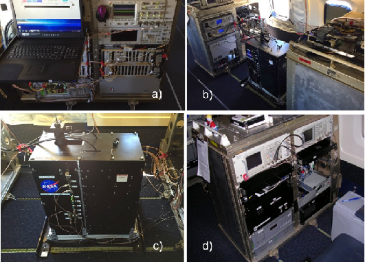
Figure 1. CO2 Sounder instrument photographs. a) The aircraft rack with the new seed laser subsystem. b) The aircraft racks containing the laser power amplifiers and the lidar's detector subsystem. c) The lidar's transmitter and receiver telescope assembly, which is positioned over the nadir window assembly in the aircraft fuselage. The optical pulses from the fiber amplifiers, and the received optical signals are coupled via fiber optics. d) The instrument operator's console, with the control computer screens folded away (Abshire et al., 2018).
Citation
Abshire, J.B. 2023. ASCENDS: Airborne CO2 LAS Retrieval, Indianapolis, IN, USA, 2014. ORNL DAAC, Oak Ridge, Tennessee, USA. https://doi.org/10.3334/ORNLDAAC/2116
Table of Contents
- Dataset Overview
- Data Characteristics
- Application and Derivation
- Quality Assessment
- Data Acquisition, Materials, and Methods
- Data Access
- References
Dataset Overview
This dataset provides in situ airborne measurements of atmospheric carbon dioxide (CO2) over Indianapolis, Indiana (IN) on September 3, 2014 during the morning commuter period with heavy traffic emissions. Stationary source emissions are also included. The observed CO2 plume downwind of the urban area, along with the prevailing wind speed and direction, enabled estimations of emission rates. CO2 was measured with an airborne CO2 Laser Absorption Spectrometer (JPL CO2LAS) developed at NASA's Jet Propulsion Laboratory (JPL) to demonstrate the airborne Integrated Path Differential-Absorption (IPDA) lidar technique as a stepping stone to a capability for global measurements of CO2 concentrations from space. The CO2LAS measures the weighted, column averaged carbon dioxide between the aircraft and the ground using a continuous-wave heterodyne technique. The instrument operates at a 2.05 micron wavelength optimized for enhancing sensitivity to boundary layer carbon dioxide. Measurements were taken onboard a DC-8 aircraft during this Active Sensing of CO2 Emissions over Nights, Days and Seasons (ASCENDS) airborne deployment. The data are provided in HDF-5 format.
Project: ASCENDS-Airborne
The ASCENDS Airborne Campaign was a multi-year effort conducted between 2011 and 2017 to support the science definition study of the Active Sensing of CO2 Emissions over Nights, Days, and Seasons (ASCENDS) mission, whose objective was to make global atmospheric column carbon dioxide (CO2) measurements without a seasonal, latitudinal, or diurnal bias. Through the airborne campaign, several NASA lidar teams made substantial advances in developing suitable lidar techniques and instruments, demonstrating lidar capabilities from aircraft, improving the understanding of the characteristics needed in the measurements, and advancing the technologies needed for the space lidar. The 2017 ASCENDS airborne deployment was flown on the NASA DC-8 in late July and early August 2017 and was planned in coordination with the NASA Arctic-Boreal Vulnerability Experiment (ABoVE) 2017 field campaign.
Related Datasets
Abshire, J.B., J. Mao, H. Riris, S.R. Kawa, and X. Sun. 2022. ASCENDS: Active Sensing of CO2 With AVOCET, California and Nevada, 2016. ORNL DAAC, Oak Ridge, Tennessee, USA. https://doi.org/10.3334/ORNLDAAC/2115
Abshire, J.B., J. Mao, H. Riris, S.R. Kawa, and X. Sun. 2022. ABoVE/ASCENDS: Active Sensing of CO2, CH4, and Water Vapor, Alaska and Canada, 2017. ORNL DAAC, Oak Ridge, Tennessee, USA. https://doi.org/10.3334/ORNLDAAC/2050
Sun, X., P.T. Kolbeck, J.B. Abshire, S.R. Kawa, and J. Mao. 2022. ABoVE/ASCENDS: Atmospheric Backscattering Coefficient Profiles from CO2 Sounder, 2017. ORNL DAAC, Oak Ridge, Tennessee, USA. https://doi.org/10.3334/ORNLDAAC/2051
Related Publications
Abshire, J. B., A.K. Ramanathan, H. Riris, G.R. Allan, X. Sun, W.E. Hasselbrack, J. Mao, S. Wu, J. Chen, K. Numata, S.R. Kawa, M.Y.M. Yang, and J. DiGangi. 2018. Airborne measurements of CO2 column concentrations made with a pulsed IPDA lidar using multiple-wavelength-locked laser and HgCdTe APD detector. Atmospheric Measurement Techniques (AMT) 11:2001-2025. https://doi.org/10.5194/amt-11-2001-2018
Allan, G.R., J.B. Abshire, H. Riris, J. Mao, W.E. Hasselbrack, K. Numata, J. Chen, R. Kawa, M. Rodriguez, and M. Stephen. 2018. Lidar measurements of CO2 column concentrations in the Arctic region of North America from the ASCENDS 2017 airborne campaign. SPIE Proceedings volume 10779, Lidar Remote Sensing for Environmental Monitoring XVI, 1077906 (24 October 2018). https://doi.org/10.1117/12.2325908
Sun, X., J.B. Abshire, A. Ramanathan, S.R. Kawa, and J. Mao. 2021. Retrieval algorithm for the column CO2 mixing ratio from pulsed multi-wavelength lidar measurements. Atmospheric Measurement Techniques 14:3909–3922. https://doi.org/10.5194/amt-14-3909-2021
Acknowledgement
This research was funded by the NASA's ASCENDS Terrestrial Ecology program. The data were produced at the Jet Propulsion Laboratory, California Institute of Technology, under contract with NASA. The CO2LAS flights were supported by ASCENDS Pre-Formulation. NASA's Earth Science Technology Office (ESTO) supported development of the CO2LAS instrument. The JPL Earth Science and Technology Directorate supported this work.
Data Characteristics
Spatial Coverage: Indianapolis, Indiana, U.S.
Spatial Resolution: Point locations
Temporal Coverage: 2014-09-03
Temporal Resolution: Varied
Study Areas: Latitude and longitude are given in decimal degrees.
| Site | Westernmost Longitude | Easternmost Longitude | Northernmost Latitude | Southernmost Latitude |
|---|---|---|---|---|
| Indianapolis, IN, US | -86.52137 | -85.75817 | 40.15296 | 39.47066 |
Data File Information
There are four data files in HDF-5 (*.h5) format with this dataset.
The files are named ASCENDS-JPL-CO2LAS_DC8_20140903_indybox_16kft_legX_R0.h5,
where X is 1, 2, 3, or 4. R0 is the revision number.
Table 1. Variables in the data files.
| Variable | Units | Description |
| alt | m | Aircraft GPS altitude |
| ang | degrees | Laser angle off nadir. Source: Aircraft telemetry (REVEAL) for the aircraft pitch angle; the laser angle relative to the aircraft frame of reference was computed from the Doppler return |
| co2 | 1e-6 | CO2 weighted column mixing ratio below aircraft-retrieved from DAOD using a forward model |
| daod | 1 | Differential absorption optical depth single pass offline-online. Computed from CO2LAS return signal power as ln(Poff/Pon) |
| elev | m | Surface elevation above mean sea from SRTM_v2 |
| range | m | Laser slant range to ground calculated from aircraft altitude and attitude. Source: REVEAL and surface elevation from SRTM |
Application and Derivation
CO2LAS was developed at JPL to demonstrate the airborne Integrated Path Differential-Absorption (IPDA) lidar technique as a stepping stone to a capability for global measurements of CO2 concentrations from space.
Quality Assessment
Not provided.
Data Acquisition, Materials, and Methods
The 2014 mission flown over Indianapolis, Indiana, gathered the CO2 weighted column mixing ratio retrieved for a box pattern flown at an altitude of about 16,000 m during the morning commuter period with heavy traffic emissions as well as stationary source emissions. The observed CO2 plume downwind of the urban area, along with the prevailing wind speed and direction, enabled determination of emission rate. CO2 was measured with the JPL CO2LAS which measures the weighted, column averaged carbon dioxide between the aircraft and the ground using a continuous-wave heterodyne technique. The instrument operates at a 2.05 micron wavelength optimized for enhancing sensitivity to boundary layer carbon dioxide.
CO2LAS was developed at JPL to demonstrate the airborne IPDA lidar technique as a stepping stone to a capability for global measurements of CO2 concentrations from space. Measurements were taken onboard a DC-8 aircraft during this Active Sensing of CO2 Emissions over Nights, Days and Seasons (ASCENDS) airborne deployment.
Data Access
These data are available through the Oak Ridge National Laboratory (ORNL) Distributed Active Archive Center (DAAC).
ASCENDS: Airborne CO2 LAS Retrieval, Indianapolis, IN, USA, 2014
Contact for Data Center Access Information:
- E-mail: uso@daac.ornl.gov
- Telephone: +1 (865) 241-3952
References
Abshire, J.B., J. Mao, H. Riris, S.R. Kawa, and X. Sun. 2022. ASCENDS: Active Sensing of CO2 With AVOCET, California and Nevada, 2016. ORNL DAAC, Oak Ridge, Tennessee, USA. https://doi.org/10.3334/ORNLDAAC/2115
Abshire, J.B., J. Mao, H. Riris, S.R. Kawa, and X. Sun. 2022. ABoVE/ASCENDS: Active Sensing of CO2, CH4, and Water Vapor, Alaska and Canada, 2017. ORNL DAAC, Oak Ridge, Tennessee, USA. https://doi.org/10.3334/ORNLDAAC/2050
Abshire, J. B., A.K. Ramanathan, H. Riris, G.R. Allan, X. Sun, W.E. Hasselbrack, J. Mao, S. Wu, J. Chen, K. Numata, S.R. Kawa, M.Y.M. Yang, and J. DiGangi. 2018. Airborne measurements of CO2 column concentrations made with a pulsed IPDA lidar using multiple-wavelength-locked laser and HgCdTe APD detector. Atmospheric Measurement Techniques (AMT) 11:2001-2025. https://doi.org/10.5194/amt-11-2001-2018
Allan, G.R., J.B. Abshire, H. Riris, J. Mao, W.E. Hasselbrack, K. Numata, J. Chen, R. Kawa, M. Rodriguez, and M. Stephen. 2018. Lidar measurements of CO2 column concentrations in the Arctic region of North America from the ASCENDS 2017 airborne campaign. SPIE Proceedings volume 10779, Lidar Remote Sensing for Environmental Monitoring XVI, 1077906 (24 October 2018). https://doi.org/10.1117/12.2325908
Sun, X., P.T. Kolbeck, J.B. Abshire, S.R. Kawa, and J. Mao. 2022. ABoVE/ASCENDS: Atmospheric Backscattering Coefficient Profiles from CO2 Sounder, 2017. ORNL DAAC, Oak Ridge, Tennessee, USA. https://doi.org/10.3334/ORNLDAAC/2051
Sun, X., J.B. Abshire, A. Ramanathan, S.R. Kawa, and J. Mao. 2021. Retrieval algorithm for the column CO2 mixing ratio from pulsed multi-wavelength lidar measurements. Atmospheric Measurement Techniques 14:3909–3922. https://doi.org/10.5194/amt-14-3909-2021