Documentation Revision Date: 2022-12-29
Dataset Version: 1
Summary
There are two data files in ICARTT format (*.ict) and two files in comma-separated values (.csv) format included in this dataset.
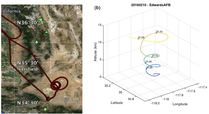
Figure 1. (a) Flight track for 10 February 2016 flight over Edwards AFB, California. (b) Time-tagged location and altitude plot for the spiral-down maneuver over Edwards AFB for the same flight (Abshire et al., 2018).
Citation
Abshire, J.B., J. Mao, H. Riris, S.R. Kawa, and X. Sun. 2022. ASCENDS: Active Sensing of CO2 With AVOCET, California and Nevada, 2016. ORNL DAAC, Oak Ridge, Tennessee, USA. https://doi.org/10.3334/ORNLDAAC/2115
Table of Contents
- Dataset Overview
- Data Characteristics
- Application and Derivation
- Quality Assessment
- Data Acquisition, Materials, and Methods
- Data Access
- References
Dataset Overview
This dataset provides in situ airborne measurements of atmospheric carbon dioxide (CO2) over California and Nevada on February 10-11, 2016. Measurements were taken onboard a DC-8 aircraft during this Active Sensing of CO2 Emissions over Nights, Days and Seasons (ASCENDS) airborne deployment. CO2 was measured with NASA's Atmospheric Vertical Observations of CO2 in the Earth's Troposphere (AVOCET) instrument while over California and Nevada. The objective of this deployment was to assess the performance of the 2016 version of the CO2 Sounder LiDAR. The two flights were flown to compare results from an experimental LiDAR sensor with the AVOCET instrument. Aircraft navigation and flight meteorological data are also provided. The data are provided in ICARTT and comma-separated values (CSV) formats.
Related Datasets
Abshire, J.B., J. Mao, H. Riris, S.R. Kawa, and X. Sun. 2022. ABoVE/ASCENDS: Active Sensing of CO2, CH4, and Water Vapor, Alaska and Canada, 2017. ORNL DAAC, Oak Ridge, Tennessee, USA. https://doi.org/10.3334/ORNLDAAC/2050
Sun, X., P.T. Kolbeck, J.B. Abshire, S.R. Kawa, and J. Mao. 2022. ABoVE/ASCENDS: Atmospheric Backscattering Coefficient Profiles from CO2 Sounder, 2017. ORNL DAAC, Oak Ridge, Tennessee, USA. https://doi.org/10.3334/ORNLDAAC/2051
Related Publications
Abshire, J. B., A.K. Ramanathan, H. Riris, G.R. Allan, X. Sun, W.E. Hasselbrack, J. Mao, S. Wu, J. Chen, K. Numata, S.R. Kawa, M.Y.M. Yang, and J. DiGangi. 2018. Airborne measurements of CO2 column concentrations made with a pulsed IPDA lidar using multiple-wavelength-locked laser and HgCdTe APD detector. Atmospheric Measurement Techniques (AMT) 11:2001-2025. https://doi.org/10.5194/amt-11-2001-2018
Allan, G.R., J.B. Abshire, H. Riris, J. Mao, W.E. Hasselbrack, K. Numata, J. Chen, R. Kawa, M. Rodriguez, and M. Stephen. 2018. Lidar measurements of CO2 column concentrations in the Arctic region of North America from the ASCENDS 2017 airborne campaign. SPIE Proceedings volume 10779, Lidar Remote Sensing for Environmental Monitoring XVI, 1077906 (24 October 2018). https://doi.org/10.1117/12.2325908
Sun, X., J.B. Abshire, A. Ramanathan, S.R. Kawa, and J. Mao. 2021. Retrieval algorithm for the column CO2 mixing ratio from pulsed multi-wavelength lidar measurements. Atmospheric Measurement Techniques 14:3909–3922. https://doi.org/10.5194/amt-14-3909-2021
Acknowledgement
This research was funded by the NASA Terrestrial Ecology program: ASCENDS.
Data Characteristics
Spatial Coverage: California and Nevada, US
Spatial Resolution: Point locations
Temporal Coverage: 2016-02-10 to 2016-02-12 with two single-day flights during the period.
Temporal Resolution: Every minute
Study Areas: Latitude and longitude are given in decimal degrees.
| Site | Westernmost Longitude | Easternmost Longitude | Northernmost Latitude | Southernmost Latitude |
|---|---|---|---|---|
| California and Nevada, US | -122.100 | -113.530 | 41.615 | 34.553 |
Data File Information
There are two data files in ICARTT format (*.ict) and two files in comma-separated values (.csv) format included in this dataset.
The .ict files are named ASCENDS-AVOCET_DC8_20160210_R0.ict and ASCENDS-AVOCET_DC8_20160211_R0.ict. These files provide CO2 observations collected from AVOCET.
The .csv files are named ASCENDS-AVOCET_DC8_20160210_R0_navigation.csv and ASCENDS-AVOCET_DC8_20160211_R0_navigation.csv. These files provide navigation and meteorological data. Refer to Table 1.
Table 1. Variables in the .csv files.
| Variable | Units | Description |
|---|---|---|
| TimeStamp | YYYY-MM-_DDThh:mm:ss.sss | Date and time as year-month-day (YYYY-MM-DD)and time as hour:minute:seconds.fraction of second |
| Latitude | degrees_north | Latitude |
| Longitude | degrees_east | Longitude |
| GPS_Alt_MSL | m | Aircraft GPS altitude above mean sea level |
| GPS_Altitude | m | Aircraft GPS altitude above WGS84 ellipsoid |
| Pressure_Altitude | ft | Aircraft altitude from air pressure |
| Radar_Altitude | ft | Aircraft radar altitude |
| Ground_Speed | m s-1 | Aircraft ground speed |
| True_Air_Speed | kts | Aircraft true air speed |
| Indicated_Air_Speed | kts | Aircraft indicated air speed |
| Mach_Number | mach | Aircraft speed in mach number |
| Vertical_Speed | m s-1 | Aircraft vertical speed |
| True_Heading | degrees | Aircraft true heading, 0-360 degrees, clockwise from +y |
| Track_Angle | degrees | Aircraft track angle, 0-360 degrees, clockwise from +y |
| Drift_Angle | degrees | Aircraft drift angle, +/-180 degrees, clockwise from +y |
| Pitch_Angle | degrees | Aircraft pitch angle, +/-180 degrees, up+ |
| Roll_Angle | degrees | Aircraft roll angle, +/-180 degrees, right+ |
| Slip_Angle | degrees | Slip angle (values not provided) |
| Attack_Angle | degrees | Angle of attack (values not provided) |
| Static_Air_Temp | degrees Celsius | Static air temperature |
| Dew_Point | degrees Celsius | Dew point temperature |
| Total_Air_Temp | degrees Celsius | An intermediate product of air temperature measurement, not corrected for air motion |
| Static_Pressure | mb | Static air pressure |
| Dynamic_Pressure | mb | Dynamic pressure (values not provided) |
| Cabin_Pressure | mb | Aircraft cabin pressure |
| Wind_Speed | m s-1 | Wind speed, limited to where Roll_Angle <= 5 degrees |
| Wind_Direction | degrees | Wind direction, 0-360 degrees, clockwise from +y |
| Vertical_Wind_Speed | m s-1 | Vertical wind speed (values not provided) |
| Solar_Zenith_Angle | degrees | Solar zenith angle |
| Aircraft_Sun_Elevation | degrees | Sun elevation angle with respect to aircraft |
| Sun_Azimuth | degrees | Sun azimuth angle |
| Aircraft_Sun_Azimuth | degrees | Sun azimuth angle with respect to aircraft |
Companion File Information
There are four companion files in .pdf format included in this dataset. The ASCENDS_AVOCET_CA_NV_Feb_2016.pdf is the dataset guide document. The NASA_TP_2018-219034_ASCENDS_ID1.pdf is the final report of the ASCENDS Ad Hoc Science Definition Team. The Co2LidarBackscatProfiles_1-19-2021_ID4.pdf summarizes the algorithm and data processing used to obtain the attenuated atmospheric backscatter profiles measured by the pulsed CO2 Sounder lidar developed by the NASA Goddard Space Flight Center (GSFC) and deployed during the 2017 ASCENDS/ABoVE airborne campaign. The ASCENDSFinalDraft81915_ID0.pdf is the draft of the ASCENDS Science Mission Definition Study.
Application and Derivation
These data contribute to our understanding and predictive capabilities for modeling the land-atmospheric exchange of CO2.
Quality Assessment
The results from both campaigns showed that the mean values of XCO2 retrieved from the lidar consistently agreed with those based on the in situ sensor to within 1 ppm (Abshire et al., 2018).
Data Acquisition, Materials, and Methods
The 2016 campaign was a short (two flight) campaign flown over the Mojave Desert and Edwards AFB, California, and a snow flight over northeast Nevada. Measurements were taken onboard a DC-8 aircraft during this ASCENDS airborne deployment. The objective was to assess the performance of the 2016 version of the CO2 Sounder lidar (Abhsire et al., 2018). Data were collected with the infrared absorption spectrometer on NASA's Atmospheric Vertical Observations of CO2 in the Earth's Troposphere (AVOCET) instrument. The two flights were flown to compare results from an experimental lidar sensor with the AVOCET instrument. Lidar data are not available and are not included with this dataset.
The 2016 desert flight was made over the Mojave Desert and Edwards AFB, which was used for the spiral down location (refer to Figure 1). The spiral-down altitudes were between 7-10 km. The 2016 snow flight targeted a long series of measurements over fresh cold snow. Snow had recently fallen in northeast Nevada and the surface temperatures had stayed below 0°C, so the flight repeated a north–south route just south of Elko, Nevada. The Elko airport was the nearest location available for the spiral-down maneuvers (Figure 2). The flight altitudes of the north–south legs of this flight were between 6.6 and 9.5 km.
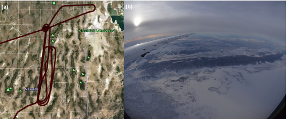
Figure 2. (a) Map of the ground track for the 2016 snow flight made over northeastern Nevada. The spiral-down location was centered on the airport at Elko NV and all subsequent measurements were made during the north–south tracks south of Elko. (b) Photograph of the snow-covered hills and desert floor made during the 2016 snow flight.
Refer to Abshire et al. (2018) for additional details.
Data Access
These data are available through the Oak Ridge National Laboratory (ORNL) Distributed Active Archive Center (DAAC).
ASCENDS: Active Sensing of CO2 With AVOCET, California and Nevada, 2016
Contact for Data Center Access Information:
- E-mail: uso@daac.ornl.gov
- Telephone: +1 (865) 241-3952
References
Abshire, J.B., J. Mao, H. Riris, S.R. Kawa, and X. Sun. 2022. ABoVE/ASCENDS: Active Sensing of CO2, CH4, and Water Vapor, Alaska and Canada, 2017. ORNL DAAC, Oak Ridge, Tennessee, USA. https://doi.org/10.3334/ORNLDAAC/2050
Abshire, J. B., A.K. Ramanathan, H. Riris, G.R. Allan, X. Sun, W.E. Hasselbrack, J. Mao, S. Wu, J. Chen, K. Numata, S.R. Kawa, M.Y.M. Yang, and J. DiGangi. 2018. Airborne measurements of CO2 column concentrations made with a pulsed IPDA lidar using multiple-wavelength-locked laser and HgCdTe APD detector. Atmospheric Measurement Techniques (AMT) 11:2001-2025. https://doi.org/10.5194/amt-11-2001-2018
Allan, G.R., J.B. Abshire, H. Riris, J. Mao, W.E. Hasselbrack, K. Numata, J. Chen, R. Kawa, M. Rodriguez, and M. Stephen. 2018. Lidar measurements of CO2 column concentrations in the Arctic region of North America from the ASCENDS 2017 airborne campaign. SPIE Proceedings volume 10779, Lidar Remote Sensing for Environmental Monitoring XVI, 1077906 (24 October 2018). https://doi.org/10.1117/12.2325908
Sun, X., P.T. Kolbeck, J.B. Abshire, S.R. Kawa, and J. Mao. 2022. ABoVE/ASCENDS: Atmospheric Backscattering Coefficient Profiles from CO2 Sounder, 2017. ORNL DAAC, Oak Ridge, Tennessee, USA. https://doi.org/10.3334/ORNLDAAC/2051
Sun, X., J.B. Abshire, A. Ramanathan, S.R. Kawa, and J. Mao. 2021. Retrieval algorithm for the column CO2 mixing ratio from pulsed multi-wavelength lidar measurements. Atmospheric Measurement Techniques 14:3909–3922. https://doi.org/10.5194/amt-14-3909-2021