Documentation Revision Date: 2019-05-10
Dataset Version: 1
Summary
The data provided here will be used for algorithm training and validation for ongoing global biomass retrieval missions and will provide standardized ground datasets across ecologically important regions for spaceborne missions including European Space Agency (ESA) Biomass, Global Ecosystem Dynamics Investigation (GEDI), and NASA-ISRO Synthetic Aperture Radar (NISAR).
There are four total data files in GeoTIFF (.tif) format: one aboveground biomass map for each site.

Figure 1. Aboveground biomass (AGB) map at 0.25-ha resolution for the Mondah study site. Source: Mabounie_AGB_50m.tif
Citation
Saatchi, S.S., J. Chave, N. Labriere, N. Barbier, M. Maxime-Rejou, A. Ferraz, and S. Tao. 2019. AfriSAR: Aboveground Biomass for Lope, Mabounie, Mondah, and Rabi Sites, Gabon. ORNL DAAC, Oak Ridge, Tennessee, USA. https://doi.org/10.3334/ORNLDAAC/1681
Table of Contents
- Dataset Overview
- Data Characteristics
- Application and Derivation
- Quality Assessment
- Data Acquisition, Materials, and Methods
- Data Access
- References
Dataset Overview
This dataset provides gridded estimates of aboveground biomass (AGB) for four sites in Gabon at 0.25 ha (50 m) resolution derived with field measurements and airborne LiDAR data collected from 2010 to 2016. The sites represent a mix of forested, savannah, and some agricultural and disturbed landcover types: Lopé site, within Lopé National Park; Mabounié, mostly forested site; Mondah Forest, protected area; and the Rabi forest site, part of the Smithsonian Institution of Global Earth Observatories world-wide network of forest plots. Plot-level biophysical measurements of tree diameter and tree height (or estimated by allometry) were performed at 1 ha and 0.25 ha scales on multiple plots at each site and used to derive AGB for each tree and then summed for each plot. Aerial LiDAR scans were used to construct digital elevation models (DEM) and digital surface models (DSM), and then the DEM and DSM were used to construct a canopy height model (CHM) at a 1 m resolution. After checking site-plot locations against the CHM, mean canopy height (MCH) was computed over 0.25 ha. A single regression model relating MCH and AGB estimates, incorporating local height based on the trunk DBH (HD) relationships, was produced for all sites and combined with the CHM layer to construct biomass maps at 0.25 ha resolution.
The data provided here will be used for algorithm training and validation for ongoing global biomass retrieval missions and will provide standardized ground datasets across ecologically important regions for spaceborne missions including ESA Biomass, Global Ecosystem Dynamics Investigation (GEDI), and NASA-ISRO Synthetic Aperture Radar (NISAR).
Project: AfriSAR
The AfriSAR mission was an airborne campaign that collected radar and field measurements of forests in Gabon, West Africa. The mission was a NASA collaboration with the European Space Agency (ESA) and the Gabonese Space Agency. During the 2016 AfriSAR campaign, NASA UAVSAR and LVIS instruments collected data that will be used to derive forest canopy height, structure, and topography. The AfriSAR data will help prepare for and calibrate current and upcoming spaceborne missions that aim to gauge the role of forests in Earth's carbon cycle.
Related Datasets:
Fatoyinbo, T., S.S. Saatchi, J. Armston, J. Poulsen, S. Marselis, N. Pinto, L. Duncanson, L.J.T. White, and K. Jeffery. 2018. AfriSAR: Mondah Forest Tree Species, Biophysical, and Biomass Data, Gabon, 2016. ORNL DAAC, Oak Ridge, Tennessee, USA. https://doi.org/10.3334/ORNLDAAC/1580
Acknowledgements:
This work was funded by the NASA AfriSAR project.
Data Characteristics
Spatial Coverage: Gabon, Africa
Spatial Resolution: 50 m
Temporal Coverage: 2016-02-21 to 2016-03-31
Temporal Resolution: once
Study Area: (All coordinates in decimal degrees.)
| Site | Westernmost Longitude | Easternmost Longitude | Northernmost Latitude | Southernmost Latitude |
|---|---|---|---|---|
| Entire extent | 9.303080556 | 11.64364444 | 0.611119444 | -1.946022222 |
| Lope | 11.64364444 | 11.55295833 | -0.1558 | -0.237155556 |
| Mabounie | 10.61801389 | 10.48231111 | -0.713997222 | -0.823480556 |
| Mondah | 9.467547222 | 9.303080556 | 0.611119444 | 0.519733333 |
| Rabi | 9.859138889 | 9.906363889 | -1.900313889 | -1.946022222 |
Data File Information:
There are 4 data files in GeoTIFF (.tif) format: 1 file for each site. Each file provides aboveground biomass estimates in units of megagrams per hectare (Mg/ha). For each file, there is one data band, the no data value is -9999, and the projection is EPSG 32732.
Data File Details
| File | Minimum Value | Maximum Value | Columns | Rows |
|---|---|---|---|---|
| Lope_AGB_50m.tif | 0.8627 | 602.4 | 202 | 180 |
| Mabounie_AGB_50m.tif | 0.00017995 | 597 | 302 | 242 |
| Mondah_AGB_50m.tif | 0.00022569 | 599.5 | 366 | 202 |
| Rabi_AGB_50m.tif | 0.087339 | 516.4 | 105 | 101 |
Companion Files
AfriSAR_AGB_Maps_PlotDetails.csv -- Vegetation structure of plot for each site. Plot sizes are provided in hectares. Aboveground biomass (Megagrams per hectare) estimated using the HD relationship.
Application and Derivation
About 85 percent of the country of Gabon is forested. Together, Gabon's forests are the second largest rainforest in the world after the Amazon. The forests are largely undisturbed by human activity; however, close proximity to oil fields and commercial logging activity has raised concern. Algorithm training and validation (i.e., cal/val algorithms) are key aspects of the ongoing global biomass retrieval missions and will help provide standardized ground datasets across regions. The data provided here will be used in cal/val algorithms for spaceborne missions including including ESA Biomass, Global Ecosystem Dynamics Investigation (GEDI), and NASA-ISRO Synthetic Aperture Radar (NISAR).
Quality Assessment
Reviews of forest imagery resulted in some plot data that were not used during model fitting because of clear visual evidence of tree loss when comparing CHM from LiDAR data acquired in 2011, and more recent optical images acquired in late 2015. The fact some data had to be discarded underlines the importance to have the best temporal concordance between ground and LiDAR data acquisition, which is not necessarily the case for all the AfriSAR campaign sites.
Data Acquisition, Materials, and Methods
Site Sampling and Data Processing
Lopé
The Lopé site, within Lopé National Park near the geographical center of Gabon, has been protected since 2007 and is a designated UNESCO World Heritage site. The land is a mosaic of high (up to 50 m) closed-canopy forest and open savannas maintained, in part, by annual grass burning.
Twelve plots (9-1 ha each, and 3-0.5 ha each) were surveyed from February to July 2016. Plots were consistently set-up following a 320° bearing (over increasing y-axis). Relative tree coordinates at the subplot level were standardized at the plot scale and then converted to absolute coordinates (UTM coordinate system) after plot bearings were corrected for magnetism (-2° declination between true and magnetic north).
Overall, 3140 trees were considered for Lopé plots. Out of the 12 Lopé plots, nine and 42 calibration points were obtained at 1 ha and 0.25 ha scale, respectively. A savanna species HD relationship was developed from height measurements of individuals belonging to either Crossopteryx febrifuga or Sarcocephalus latifolius species, and was applied to trees from both Lopé and Mabounié sites. Airborne lidar scanning had an average point density of 2.42 m2 for all points and 0.095 m2 for ground points.
Mabounié
The Mabounié site is part of a project called Maboumine, initiated in 2005, and located approximately 40 km from the city of Lambaréné. The area is mostly forested, but has local degradation (esp. owing to road building).
Twelve plots of 1 ha each were surveyed from May to October 2012. Plot bearings were obtained from GPS coordinates (20 GPS points per plot) and 20 m by 20 m subplot coordinates. AGB was estimated both at 1 ha and 0.16 ha (i.e., 40 m2, encompassing the four subplots closest to each of the 1 ha plot corners).
Overall, 4424 trees were considered for Mabounié plots. Out of the 12 Mabounié plots, 12 and 48 calibration points were obtained at 1 ha and 0.16 ha scale, respectively. Airborne lidar scanning had an average point density was 4.31 m2 for all points and 0.084 m2 for ground points. Some small regions in Mabounie site did not have LiDAR data, thus the CHM values at these regions are invalid.
Mondah
Mondah Forest, in northwest Gabon, is a partially flooded area containing mangrove and mahogany woodlands. Its proximity to Gabon's capital of Libreville has placed the forest under environmental pressure, and some areas have been cleared for agriculture.
Fifteen plots of 1 ha each were surveyed in February 2016. Relative tree coordinates at the subplot level were standardized at the plot scale and then converted to absolute coordinates (using the UTM coordinate system) after plot bearings were obtained from GPS coordinates (25 GPS points per plot).
Overall, 4050 trees were considered for Mondah plots. Out of the 15 Mondah plots, 15 and 60 calibration points were obtained at 1 ha and 0.25 ha scale, respectively. A site-specific HD relationship was developed for Mondah because tree height for a given diameter was consistently lower than at other sites. The average point density for all points was 30.5 m2 and 2.3 m2 for ground points. Large regional difference in point density was observed despite the high average point density.
Rabi
The Rabi site is an onshore oil-drilling location owned by the Shell company, operational since 1989. A portion of the area was established as part of the Smithsonian Institution of Global Earth Observatories world-wide network of forest plots..
A single 25 ha plot was surveyed from June 2010 to June 2012. Relative tree coordinates at plot level were converted to absolute coordinates (using the UTM coordinate system) after plot bearings were obtained from corner coordinates (four points per plot). While corrections were consistently < 10 m either on easting and northing at other sites, the initial plot location at the Rabi site had to be shifted by -114 m and 42 m on easting and northing, respectively, to obtain better agreement between the locations of large trees and CHM.
Overall, 11601 trees were considered for Rabi plots. For the Rabi plot, 25 and 100 calibration points were obtained at 1 ha and 0.25 ha scale, respectively. No tree height measurements were available for Rabi plots, so the single HD relationship built from Lopé and Mabounié sites was applied to trees across the Rabi site. The average point density for all points was 2.5 m2 and 0.048 m2 for ground points.
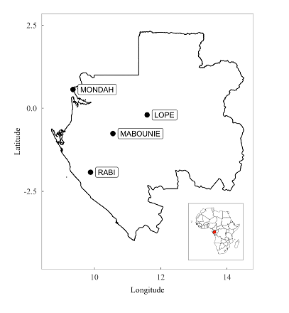
Figure 2. Locations of the four sites selected for estimating aboveground biomass.
| Site | Ground Survey Date | LiDAR Observation Date | Plot Summary |
|---|---|---|---|
| Lopé | Feb 2016 | July 2015 | Fifteen plots of 1 ha each have been surveyed in February 2016 by ANPN (the Gabonese national agency for national parks) staff on behalf of NASA. |
| Mabounié | Feb - Jul 2016 | July 2015 | Twelve plots (9 of 1ha each, and 3 of 0.5ha each) have been set up from February to July 2016 by Nicolas Labrière and ANPN staff. |
| Mondah | May - Oct 2012 | 2011 | Twelve plots of 1 ha each have been set up and surveyed by IRD (Institut de Recherche pour le Développement) |
| Rabi | Jun 2010 - Jun 2012 | July 2015 | One plot of 25 ha has been set up by CTFS (Center for Tropical Forest Science) between mid 2010 to mid 2012 . |
Field Measurements and Biomass Estimates
At all sites, only trees with > 10 cm diameter at 130 cm (DBH) were used because minimum tree diameter varied across sites. Lianas were ignored. Aboveground biomass (AGB) estimates were produced at 1 ha and 0.25 ha, except for the Mabounié site (see site details below). When possible, tree height was estimated based on the trunk DBH (henceforth, HD relationship). AGB was estimated per plot by summing AGB for all trees within the plot. The individual tree-plot measurement data are not provided with this dataset.
LiDAR Observations Derived Products
Aerial LiDAR scanning was acquired for all sites. Dates of LiDAR data acquisition are not provided. A digital elevation model (DEM) was constructed at 1 m2 resolution by interpolating ground points, a digital surface model (DSM) was constructed at 1 m2 resolution by interpolating top-canopy points, and a canopy height model (CHM) was constructed as a difference between the DSM and DEM, also at 1 m2 resolution. Mean canopy height (MCH) was computed over 0.25 ha (50 m2) based on the CHM. The respective site DEM, DSM, CHM and MCH products are not provided with this dataset.Locations of plots within sites were checked against the LiDAR-derived CHM by controlling the location of trees. This typically resulted in shifting the plot location for large trees (4% largest individuals per plot based on DBH) by < 10 m either on easting and northing, except for the Rabi site.
AGB Map Generation
DEM, and CHM were generated for all sites using at 1 m resolution with pits and spikes removed by replacing each point with a circle of 0.5 m radius, except for the Mondah site which had a 0.3 m radius circle. Several plots were not used during model fitting owing tor visual evidence of tree loss when comparing CHM (LiDAR data acquired in 2011) and more recent optical images (acquired in late 2015).
A single regression model relating MCH and AGB estimates, incorporating local height based on the trunk DBH (HD) relationships, was produced for all sites and combined with the CHM layer to construct biomass maps at 0.25 ha resolution.
Data Access
These data are available through the Oak Ridge National Laboratory (ORNL) Distributed Active Archive Center (DAAC).
AfriSAR: Aboveground Biomass for Lope, Mabounie, Mondah, and Rabi Sites, Gabon
Contact for Data Center Access Information:
- E-mail: uso@daac.ornl.gov
- Telephone: +1 (865) 241-3952