Documentation Revision Date: 2021-01-14
Dataset Version: 1.1
Summary
This product is an improvement of the 2014 DoB algorithm (Billmire et al., 2014) and uses the MODIS active fire detections (MCD14ML) from Collection 6 to determine the date of burning within 1 km buffered fire scars found in the AICC and NRC databases. Data for the period 2001–2015 were first published in 2017, and data for the period 2016–2019 were added in January 2021.
There are 38 Shapefiles in compressed (*.zip) format provided in this dataset provided, including 19 files for the date of burning (DoB) of fire scars and 19 files for filtered MODIS daily active fire locations across Canada and Alaska for the period 2001–2019. Identical companion files in Keyhole Markup Language (*.kmz) format are included for viewing in Google Earth.
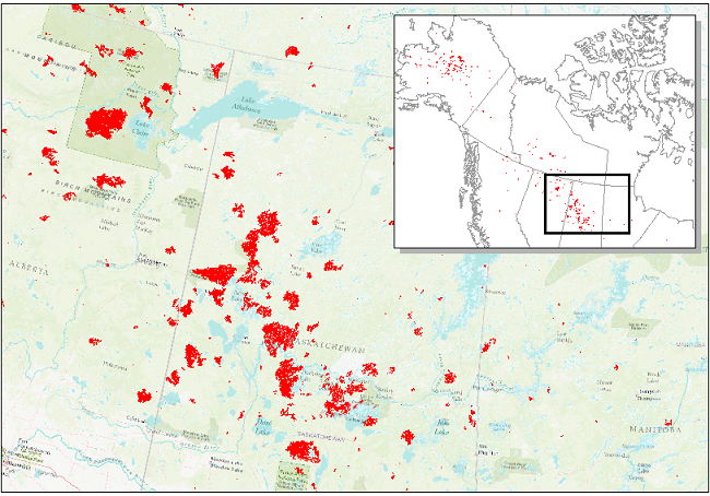
Figure 1. Date of Burning (DoB) estimated for areas within each fire scar (inset) across Alaska and Canada. Red areas show fire scar locations across central Canada (detail) in 2015.
Citation
Loboda, T.V., J.V. Hall, and A. Baer. 2017. ABoVE: Wildfire Date of Burning within Fire Scars across Alaska and Canada, 2001-2019. ORNL DAAC, Oak Ridge, Tennessee, USA. https://doi.org/10.3334/ORNLDAAC/1559
Table of Contents
- Dataset Overview
- Data Characteristics
- Application and Derivation
- Quality Assessment
- Data Acquisition, Materials, and Methods
- Data Access
- References
- Dataset Revisions
Dataset Overview
This dataset provides estimates of wildfire progression represented by date of burning (DoB) within fire scars across Alaska and Canada for the period 2001–2019. Burn scar locations were obtained from two datasets: the Alaskan Interagency Coordination Center (AICC) and the Natural Resources Canada (NRC) databases. All scars within these databases were used in this study. The estimated DoB was derived using an algorithm for identifying the first fire occurrence from the Moderate Resolution Imaging Spectroradiometer (MODIS) active fire detection product (MCD14ML, Collection 6) and to subsequently determine all dates of burning within fire scars. The DoB data are provided as polygons and map the daily progression of a fire within each burn scar. As a result, there is one polygon for each DoB detected within an identified burn scar boundary. The MODIS active fire points associated with the burn scar data are also provided. Data for the period 2001–2015 were first published in 2017 and data for the period 2016–2019 were added in January 2021.
This product is an improvement of the 2014 DoB algorithm (Billmire et al., 2014) and uses the MODIS active fire detections (MCD14ML) from Collection 6 to determine the date of burning within 1 km buffered fire scars found in the AICC and NRC databases. Data for the period 2001–2015 were first published in 2017, and data for the period 2016–2019 were added in January 2021.
Project: Arctic-Boreal Vulnerability Experiment
The Arctic-Boreal Vulnerability Experiment (ABoVE) is a NASA Terrestrial Ecology Program field campaign being conducted in Alaska and western Canada, for 8 to 10 years, starting in 2015. Research for ABoVE links field-based, process-level studies with geospatial data products derived from airborne and satellite sensors, providing a foundation for improving the analysis, and modeling capabilities needed to understand and predict ecosystem responses to, and societal implications of, climate change in the Arctic and Boreal regions.
Acknowledgments
This study was funded by NASA's Arctic-Boreal Vulnerability Experiment (grant NNX13AK44G).
Data Characteristics
Spatial Coverage: Alaska and Canada
ABoVE Reference Locations
Domain: Core ABoVE
State/territory: Alaska and Canada
Spatial Resolution: Burn scar and DoB data are represented by vector polygons. MODIS active fires are vector points.
Temporal Coverage: 2001-01-01 to 2019-12-31
Temporal Resolution: Daily
Study Area: Latitude and longitude are given in decimal degrees.
| Site | Westernmost Longitude | Easternmost Longitude | Northernmost Latitude | Southernmost Latitude |
|---|---|---|---|---|
| Alaska and Canada | -178.841 | -53.82671 | 70.15916 | 41.74560 |
Data File Information
There are 38 Shapefiles in compressed (*.zip) format provided in this dataset provided, including 19 files for the date of burning (DoB) of fire scars and 19 files for filtered MODIS daily active fire locations across Canada and Alaska for the period 2001–2019. Identical companion files in Keyhole Markup Language (*.kmz) format are included for viewing in Google Earth. The file naming convention is ABoVE_DoB_YYYY.zip and ABoVE_DoB_MODIS_Active_Fires_YYYY.zip, where YYYY is the year of the fire.
NOTE: Data for the period 2016–2019 were added in November 2020 (Version 1.1). Date of burning and active fire locations were determined using the same process as for earlier data. There were no changes to previously released data.
Table 1. File names and descriptions.
| File Name | Description |
|---|---|
| ABoVE_DoB_YYYY.zip | Shapefile bundle for the date of burning fires for the period 2001–2019 |
| ABoVE_DoB_MODIS_Active_Fires_YYYY.zip | Shapefile bundle for the daily active fire locations in Canada and Alaska for the period 2001–2019 |
Data File Details
Table 2. Variable name and descriptions for files named ABoVE_DoB_YYYY.zip.
| Variable | Description |
|---|---|
| UID_Fire | Unique identifier assigned for each fire event that occurred in the study area during the specific year. The same UID_Fire can be repeated during subsequent years |
| Year | Year of mapping |
| Map_date | Date of Burning. Format = YYYY-MM-DD. Null value = 0000-00-00 |
| JD | Day of year. Valid values = 1–365 (or 366 for leap year); Null value = 0 |
| FD_Agency |
Fire Database Reference AK = Alaskan Interagency Coordination Center (AICC) Database |
| REF_ID |
Fire Reference ID from the original Fire Database. For the AICC Database, the value provided is the database value for “FIREID", and for the NRC Database the value provided is the database value for “CFS_REF_ID”. |
| date_src |
Used to define the data source of the mapping date. FPM = Date obtained from the Fire Progression Model |
Table 3. The number of Fire Database (FD) scars that were allocated to each data source. See Table 2 for details.
| Year | Total FD scars | FPM | 1AF | FD | NA |
|---|---|---|---|---|---|
| 2001 | 751 | 105 | 31 | 119 | 496 |
| 2002 | 859 | 325 | 63 | 125 | 346 |
| 2003 | 1120 | 434 | 61 | 178 | 447 |
| 2004 | 920 | 567 | 39 | 308 | 6 |
| 2005 | 945 | 445 | 42 | 455 | 3 |
| 2006 | 1472 | 434 | 86 | 947 | 5 |
| 2007 | 1225 | 363 | 67 | 774 | 21 |
| 2008 | 1277 | 299 | 75 | 896 | 7 |
| 2009 | 1261 | 396 | 87 | 770 | 8 |
| 2010 | 1771 | 503 | 107 | 1154 | 7 |
| 2011 | 904 | 320 | 58 | 520 | 6 |
| 2012 | 1400 | 498 | 83 | 810 | 9 |
| 2013 | 1528 | 532 | 97 | 887 | 12 |
| 2014 | 1140 | 399 | 63 | 676 | 2 |
| 2015 | 2092 | 858 | 113 | 1088 | 33 |
| 2016 | 1177 | 325 | 71 | 774 | 7 |
| 2017 | 1718 | 617 | 94 | 1004 | 3 |
| 2018 | 1955 | 663 | 117 | 1170 | 5 |
| 2019 | 1188 | 356 | 84 | 748 | 356 |
Table 4. Variable name and descriptions for files named âÂÂÂÂÂÂÂÂABoVE_DoB_MODIS_Active_Fires_YYYY.zip. Columns 1-11 are variables from the original MCD14ML product. Variables 12-16 were added for the Active Fire Product. Variable 12 is available for only the period 2016–2019.
| Column | Variable | Units | Description |
|---|---|---|---|
| 1 | YYYYMMDD | UTC year (YYYY), month (MM), and day (DD) | |
| 2 | HHMM | UTC hour (HH) and minute (MM) | |
| 3 | sat | Satellite: Terra (T) or Aqua (A) | |
| 4 | lat | decimal degrees | Latitude at center of fire pixel |
| 5 | lon | decimal degrees | Longitude at center of fire pixel |
| 6 | T21 | degrees K | Band 21 brightness temperature of fire pixel |
| 7 | T31 | degrees K | Band 31 brightness temperature of fire pixel |
| 8 | sample | Sample number (range 0–1353) | |
| 9 | FRP | MW | Fire radiative power (FRP) |
| 10 | conf | % | Detection confidence (range 0–100) |
| 11 | type |
Inferred hot spot type. 0 = presumed vegetation fire |
|
| 12 | dn | Day/Night Algorithm Flag | D = daytime N = nighttime |
| 13 | UID_Fire | Unique identifier assigned for each fire event that occurred in the study area during the specific year. The same UID_Fire can be repeated during subsequent years | |
| 14 | Status |
Indicates the level of filtering applied to the Active Fire point. primary = MODIS Active Fire points used within the IDW interpolation |
|
| 15 | FD_Agency |
Fire Database Reference. AK = Alaskan Interagency Coordination Center (AICC) Database |
|
| 16 | REF_ID | Fire Reference ID from the original Fire Database. For the AICC Database, the value provided is the database value for “FIREID", and for the NRC Database the value provided is the database value for “CFS_REF_ID”. |
Spatial Properties of Shapefiles
EPSG: 102001
PROJCS["Canada_Albers_Equal_Area_Conic",
GEOGCS["GCS_North_American_1983",
DATUM["D_North_American_1983",
SPHEROID["GRS_1980",6378137.0,298.257222101]],
PRIMEM["Greenwich",0.0],
UNIT["Degree",0.0174532925199433]],
PROJECTION["Albers"],
PARAMETER["False_Easting",0.0],
PARAMETER["False_Northing",0.0],
PARAMETER["Central_Meridian",-96.0],
PARAMETER["Standard_Parallel_1",50.0],
PARAMETER["Standard_Parallel_2",70.0],
PARAMETER["Latitude_Of_Origin",40.0],
UNIT["Meter",1.0]]
Table 5. Spatial extents of the shapefiles.
| Shapefile Name | Northernmost Latitude | Southernmost Latitude | Easternmost Longitude | Westernmost Longitude |
|---|---|---|---|---|
| ABoVE_DoB_2001.shp | 79.62475 | 28.89674 | -27.5605 | -178.851 |
| ABoVE_DoB_2002.shp | 79.26801 | 39.49561 | -28.3421 | -169.709 |
| ABoVE_DoB_2003.shp | 80.25712 | 36.63773 | -26.0811 | -169.876 |
| ABoVE_DoB_2004.shp | 79.51588 | 37.26822 | -28.9261 | -167.477 |
| ABoVE_DoB_2005.shp | 79.21216 | 35.11068 | -38.6583 | -170.388 |
| ABoVE_DoB_2006.shp | 76.37066 | 36.09079 | -33.8209 | -166.337 |
| ABoVE_DoB_2007.shp | 79.64559 | 39.51355 | -28.9521 | -169.671 |
| ABoVE_DoB_2008.shp | 78.41748 | 40.21596 | -29.5072 | -168.261 |
| ABoVE_DoB_2009.shp | 78.7255 | 39.80437 | -29.0477 | -168.375 |
| ABoVE_DoB_2010.shp | 79.69768 | 36.02449 | -38.8742 | -170.136 |
| ABoVE_DoB_2011.shp | 79.32386 | 41.5503 | -31.2824 | -165.643 |
| ABoVE_DoB_2012.shp | 80.45651 | 39.84391 | -25.851 | -171.771 |
| ABoVE_DoB_2013.shp | 78.14374 | 40.53107 | -32.3789 | -166.481 |
| ABoVE_DoB_2014.shp | 79.37394 | 40.60062 | -28.788 | -168.146 |
| ABoVE_DoB_2015.shp | 80.07437 | 39.53679 | -22.1843 | -171.476 |
| ABoVE_DoB_2016.zip | 68.60278 | 43.69844 | -56.6044 | -171.411 |
| ABoVE_DoB_2017.zip | 69.95171 | 43.56071 | -59.8641 | -163.197 |
| ABoVE_DoB_2018.zip | 68.39109 | 43.53752 | -57.249 | -166.188 |
| ABoVE_DoB_2019.zip | 69.46963 | 45.13534 | -60.5945 | -165.854 |
| ABoVE_DoB_MODIS_Active_Fires_2001.shp | 74.39441 | 44.51606 | -39.1757 | -154.054 |
| ABoVE_DoB_MODIS_Active_Fires_2002.shp | 78.94646 | 39.82787 | -28.9974 | -168.529 |
| ABoVE_DoB_MODIS_Active_Fires_2003.shp | 79.16242 | 36.71709 | -29.5627 | -167.744 |
| ABoVE_DoB_MODIS_Active_Fires_2004.shp | 79.50891 | 40.93674 | -32.0034 | -167.444 |
| ABoVE_DoB_MODIS_Active_Fires_2005.shp | 79.18593 | 39.22152 | -38.7358 | -170.25 |
| ABoVE_DoB_MODIS_Active_Fires_2006.shp | 76.36248 | 39.09417 | -34.6674 | -166.325 |
| ABoVE_DoB_MODIS_Active_Fires_2007.shp | 79.16532 | 40.14741 | -29.8921 | -168.828 |
| ABoVE_DoB_MODIS_Active_Fires_2008.shp | 78.4134 | 40.21209 | -29.5268 | -168.26 |
| ABoVE_DoB_MODIS_Active_Fires_2009.shp | 78.72369 | 40.54558 | -29.0617 | -166.813 |
| ABoVE_DoB_MODIS_Active_Fires_2010.shp | 79.69872 | 36.02766 | -36.777 | -170.139 |
| ABoVE_DoB_MODIS_Active_Fires_2011.shp | 78.84153 | 41.56533 | -32.9378 | -164.732 |
| ABoVE_DoB_MODIS_Active_Fires_2012.shp | 80.44758 | 39.90664 | -25.8889 | -171.646 |
| ABoVE_DoB_MODIS_Active_Fires_2013.shp | 77.72753 | 41.66693 | -33.2133 | -165.75 |
| ABoVE_DoB_MODIS_Active_Fires_2014.shp | 79.36979 | 41.95637 | -38.0751 | -167.803 |
| ABoVE_DoB_MODIS_Active_Fires_2015.shp | 80.06294 | 39.73405 | -27.8063 | -171.25 |
| ABoVE_DoB_MODIS_Active_Fires_2016.zip | 68.2003 | 44.46839 | -57.5433 | -163.626 |
| ABoVE_DoB_MODIS_Active_Fires_2017.zip | 69.53299 | 43.94309 | -64.6639 | -163.181 |
| ABoVE_DoB_MODIS_Active_Fires_2018.zip | 68.3761 | 44.54529 | -59.9997 | -166.139 |
| ABoVE_DoB_MODIS_Active_Fires_2019.zip | 68.9331 | 45.38739 | -63.5919 | -165.859 |
Application and Derivation
These data aid in understanding fire progression across landscapes both temporally and spatially. In addition, these data could be useful in studies related to carbon storage, biomass, and climate change.
Quality Assessment
Caveats and Known Problems
There are fire scars mapped within the Alaskan Interagency Coordination Center (AICC) and the Natural Resources Canada (NRC) databases that contain neither dates of detection nor active fire data. These mapped scars have been given a value of 0.
During 2001 and 2002, the MODIS instrument was turned off for substantial periods of time and therefore no active fire detections were acquired.
The annual merged shapefile contains overlapping scars. The unique identifier or reference ID can be used to extract specific scars of interest.
Data Acquisition, Materials, and Methods
This product is an improvement to the 2014 DoB algorithm (Billmire et al., 2014) and uses the MODIS active fire detections (MCD14ML) from Collection 6 to determine the date of burning within a 1 km buffered fire scars found in the Alaskan Interagency Coordination Center (AICC; fire.ak.blm.gov) and the Natural Resources Canada (NRC; www.nrcan.gc.ca) databases. All scars within these databases were used in this study.
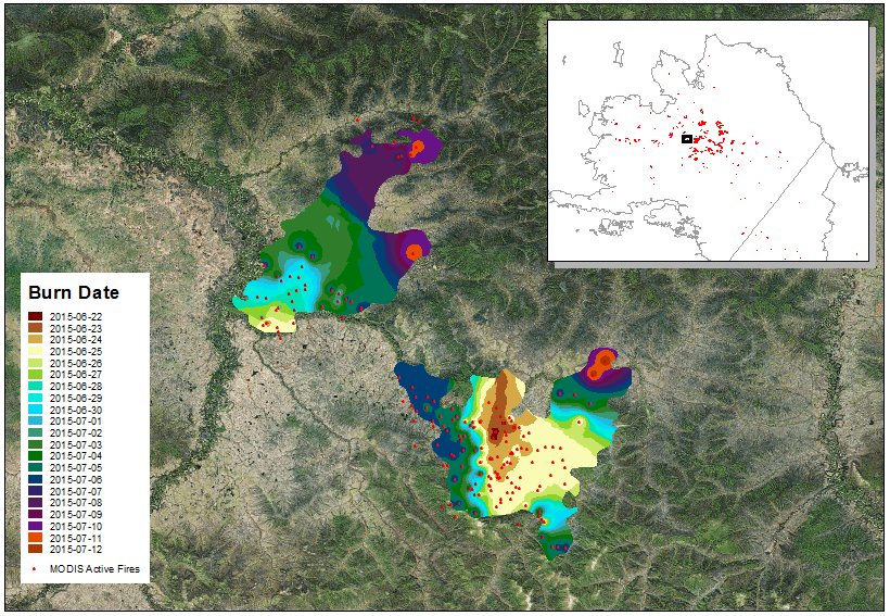
Figure 2. A typical number of DoB polygons in two Alaskan fire scars and the associated MODIS active file points in 2015. The DoB data are provided as polygons to map the progression of a fire within each burn scar. There is one polygon for each DoB detected within an identified burn scar boundary.
A consecutive 20-day filter was applied to the active fires (i.e., filtered to include only presumed vegetation fires, type=0) on a per scar basis to remove any temporally anomalous fires (Giglio et al., 2003; Giglio, 2015). In addition, further filtering was applied to remove any anomalous fires within active fire clusters. To account for the off-nadir viewing angle geolocation inaccuracies and to remove any residual burning, a 100 m radius buffer was applied to the first instance of fire detection.
Inverse distance weighting (IDW) interpolation was used to determine the fire spread through linearly weighting the active fire dates. For this product, a mapping cell size of 30 m was used in the IDW interpolation. Any scars containing only one active fire point were allocated the date from that active fire detection. Any scars that did not contain MODIS active fire detections were allocated the date of mapping based on the AICC and NRC dates. Any scars which contained neither MODIS active fire detections nor a mapping date within the FD were allocated a zero value.
Data Access
These data are available through the Oak Ridge National Laboratory (ORNL) Distributed Active Archive Center (DAAC).
ABoVE: Wildfire Date of Burning within Fire Scars across Alaska and Canada, 2001-2019
Contact for Data Center Access Information:
- E-mail: uso@daac.ornl.gov
- Telephone: +1 (865) 241-3952
References
Billmire, M., N. H. F. French, T. Loboda, R. C. Owen, and M. Tyner. 2014. Santa Ana winds and predictors of wildfire progression in southern California. International Journal of Wildland Fire 23:1119. http://dx.doi.org/10.1071/WF13046
Giglio, L. 2015. MODIS Collection 6 Active Fire Product User’s Guide Revision A. Unpublished manuscript, Department of Geographical Sciences, University of Maryland. https://cdn.earthdata.nasa.gov/conduit/upload/3865/MODIS_C6_Fire_User_Guide_A.pdf
Giglio, L., J. Descloitres, C.O. Justice, and Y.J. Kaufman. 2003. An Enhanced Contextual Fire Detection Algorithm for MODIS. Remote Sensing of Environment 87:273–282. http://dx.doi.org/10.1016/S0034-4257(03)00184-6
Loboda, T.V., and J.V. Hall. 2017. ABoVE: Wildfire Date of Burning within Fire Scars across Alaska and Canada, 2001-2015. ORNL DAAC, Oak Ridge, Tennessee, USA. https://doi.org/10.3334/ORNLDAAC/1559
MODIS Collection 6 NRT Hotspot / Active Fire Detections MCD14ML distributed from NASA FIRMS. Available on-line [https://earthdata.nasa.gov/earth-observation-data/near-real-time/firms]. https://doi.org/10.5067/FIRMS/MODIS/MCD14ML
Dataset Revisions
| Version | Release Date | Revision Notes |
|---|---|---|
| 1.1 | 2021-01-11 | Data for the period 2016–2019 were added. Date of burning and active fire locations were determined using the same process as version 1.0. Data for the period 2001–2015 from version 1.0 were not changed. |
| 1.0 | 2018-01-30 | Data updated. The citation was Lobota, 2017. |
| 1.0 | 2017-12-27 | Initial publication. |