Documentation Revision Date: 2019-10-22
Dataset Version: 1
Summary
The nadir photos were taken from a height of approximately 1.4 m and captured roughly 1 x 1.3 m of ground area. In plots with tall shrubs (>1.4 m), the camera may have been raised up to ~2 m to capture the top of the canopy. The center coordinates of each plot photo were measured using a TopCon GR-3 survey grade GNSS system operating in real-time kinematic (RTK) mode (nominal accuracy 4 cm).
There are 731 photos in .jpg format and one file in comma-separated format (.csv) with this dataset. The photos are provided in three compressed files (*.zip) named for the three broad study areas. The .csv file provides the photo names and the coordinates of the location where each photo was taken.

Figure 1: An example plot photo (#0656) taken at the largest study area 'Toolik' at elevation 765.7 m. The small white object was included in many of the photos as a color reference. The photographer's boots are also often visible, in this photo they are to the lower left of the white object.
Citation
Greaves, H.E., and E.A. Fortin. 2019. Ground-Based Vegetation Community Photos, Toolik Lake Area, Alaska, 2014-2015. ORNL DAAC, Oak Ridge, Tennessee, USA. https://doi.org/10.3334/ORNLDAAC/1718
Table of Contents
- Dataset Overview
- Data Characteristics
- Application and Derivation
- Quality Assessment
- Data Acquisition, Materials, and Methods
- Data Access
- References
Dataset Overview
This dataset contains 731 ground-based nadir vegetation community and ground surface photographs of selected field plots taken as ground reference data for vegetation classification studies at three areas near Toolik Lake, Alaska during the summers of 2014 and 2015. The largest area, 'Toolik', (approximately 6 km2) covers research areas near Toolik Field Station at Toolik Lake, including Arctic LTER installations. The other two areas are each roughly 3 km2: the 'Pipeline' area: a stretch of the Trans-Alaska Pipeline, and the 'Imnavait' area: along Imnavait Creek roughly 10 km east of Toolik Lake.
The nadir photos were taken from a height of approximately 1.4 m and captured roughly 1 x 1.3 m of ground area. In plots with tall shrubs (>1.4 m), the camera may have been raised up to ~2 m to capture the top of the canopy. The center coordinates of each plot photo were measured using a TopCon GR-3 survey grade GNSS system operating in real-time kinematic (RTK) mode (nominal accuracy 4 cm).
Project: Arctic-Boreal Vulnerability Experiment
The Arctic-Boreal Vulnerability Experiment (ABoVE) is a NASA Terrestrial Ecology Program field campaign based in Alaska and western Canada between 2016 and 2021. Research for ABoVE links field-based, process-level studies with geospatial data products derived from airborne and satellite sensors, providing a foundation for improving the analysis and modeling capabilities needed to understand and predict ecosystem responses and societal implications.
Related Datasets:
Greaves, H.E., J. Eitel, L. Vierling, N. Boelman, K. Griffin, T. Magney, and C. Prager. 2019. High-Resolution Vegetation Community Maps, Toolik Lake Area, Alaska, 2013-2015. ORNL DAAC, Oak Ridge, Tennessee, USA. https://doi.org/10.3334/ORNLDAAC/1690
Greaves, H.E., L. Vierling, J. Eitel, N. Boelman, T. Magney, C. Prager, and K. Griffin. 2018. High-Resolution Shrub Biomass and Uncertainty Maps, Toolik Lake Area, Alaska, 2013. ORNL DAAC, Oak Ridge, Tennessee, USA. https://doi.org/10.3334/ORNLDAAC/1573
Related Publication:
Heather Greaves, Jan Eitel, Lee Vierling, Natalie Boelman, Kevin L Griffin, Troy S Magney and Case M Prager. 2019. 20 cm resolution mapping of tundra vegetation communities provides an ecological baseline for important research areas in a changing Arctic environment. Environmental Research Communications. https://doi.org/10.1088/2515-7620/ab4a85.
Acknowledgements:
This research was funded by NASA Terrestrial Ecology and a NASA Earth Science Fellowship (grants NNX12AK83G and NNX15AP04H).
Data Characteristics
Spatial Coverage: The Toolik Lake area of the Alaskan North Slope
ABoVE Reference Locations:
Domain: Core ABoVE
State/territory: Alaska
Grid cells: Ah2Av1.Bh12Bv11.Ch75Cv71, Ah2Av1.Bh12Bv11.Ch76Cv71, Ah2Av1.Bh13Bv10.Ch79Cv65 Ah2Av1.Bh13Bv11.Ch79Cv66, Ah2Av1.Bh13Bv11.Ch78Cv67, Ah2Av1.Bh13Bv11.Ch79Cv67 Ah2Av1.Bh13Bv11.Ch83Cv67, Ah2Av1.Bh14Bv11.Ch84Cv67, Ah2Av1.Bh12Bv11.Ch77Cv68 Ah2Av1.Bh13Bv11.Ch78Cv68, Ah2Av1.Bh12Bv11.Ch76Cv69, Ah2Av2.Bh12Bv12.Ch75Cv72 Ah2Av1.Bh12Bv11.Ch76Cv70
Spatial Resolution: multiple points
Temporal Coverage: 2014-06-17 to 2015-07-31.
Study Area: (all latitudes and longitudes given in decimal degrees)
|
Site (Region) |
Westernmost Longitude |
Easternmost Longitude |
Northernmost Latitude |
Southernmost Latitude |
|---|---|---|---|---|
|
Toolik Lake area in Alaska |
-149.662 |
-149.292 |
68.64954 |
68.60396 |
Data File Information
There are 731 photos in .jpg format and one file in comma-separated format (.csv) with this dataset.
The photos are provided in three compressed files (.zip) named for the three study areas: Toolik.zip, Pipeline.zip, and Imnavait.zip.
The photos number are not necessarily sequential in the study area *.zip files. The Vegetation_Photos_Toolik_Lake.csv file associates the site with a photo number and location.
Table 1. Contents of Vegetation_Photos_Toolik_Lake.csv
| Column name | Description |
|---|---|
|
site |
Site where photo was taken |
|
photo_name |
Photo file name (e.g., IMG_0418.JPG). |
|
easting |
Easting cm-precision RTK GNSS coordinates (NAD83 UTM 6N) of the location where each photo was taken |
|
northing |
Northing cm-precision RTK GNSS coordinates (NAD83 UTM 6N) of the location where each photo was taken |
|
elevation |
Elevation of site area |
Coordinate Reference System:
EPSG: 26906 (NAD 1983 UTM Zone 6N)
Application and Derivation
The photos provided with this dataset serve as a reference to vegetation present for the time period. The data could be useful to climate change impact studies. The photos also complement the related datasets listed in the Overview Section of this dataset as they were taken at the same study areas.
Quality Assessment
Photos and field reference data (not included with this dataset) were collected from across all footprints in summer 2014 and summer 2015. The majority of plot locations (n = 592) were established in advance using a stratified random scheme.
No consistent length scale or color reference are included in the photos; however, in some photos a 2-m folding measuring stick is included, folded at 90 degrees to create a 1-m x 1-m corner. A small circular white reference ~6-cm in diameter (covered in white duct tape) is frequently included.
Data Acquisition, Materials, and Methods
Study areas
The study area included three areas near Toolik Lake, Alaska. The largest and westernmost area, Toolik, at ~6 km2, covers research areas near Toolik Field Station at Toolik Lake. The other two areas are each roughly 3 km2: the Pipeline area, ~3 km east of Toolik Lake, follows a stretch of the Trans-Alaska Pipeline from a high moraine ridge down a sloping drainage toward the Kuparuk River; the Imnavait area includes research areas along Imnavait Creek, roughly 10 km east of Toolik Lake. Vegetation is primarily graminoid tundra, especially Eriophorum vaginatum and Carex bigelowii, with abundant Sphagnum, lichens, mosses, and erect deciduous shrubs, particularly Betula nana and Salix species.
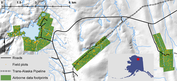
Figure 2. Map indicating the locations of the study areas. From left: Toolik, Pipeline, Imnavait and locations of reference plots (orange dots). Inset map shows the location of the study area in Alaska (Greaves et al., 2019, in process).
Reference plots and photos
Photos and field reference data (not included with this dataset) were collected from across all footprints in summer 2014 and summer 2015. The majority of plot locations (n = 592) were established in advance using a stratified random scheme to ensure inclusion of ranges of slope, aspect, elevation, and glacial history across all footprints. An additional 47 plots were collected in the course of visiting the stratified random plots, to capture a wider range of shrub characteristics, and 92 more plots were collected in 2015 to represent additional shrub types and vegetation across topographic transects. Elevation of the plots ranged from 717.843 m to 972.585 m.
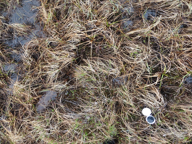
Figure 3. This is image # 0876 taken at the largest study area “Toolik”, at a lower plot elevation of 717.995 m. Elevation range of the study areas was 717. 843 to 972.585 m.
Nadir photographs were taken for each of the 731 total field plots from approximately 1.4 m height using a Canon Powershot SX260 held at arm's length at shoulder height, capturing roughly 1 x 1.3 m of ground area. Some photos are 9-megapixel square (1:1) images; the majority are 12-megapixel (4:3) images. In areas of tall shrubs (>1.4 m), the camera may have been raised up to ~2 m to capture the top of the canopy. The center coordinates of each photo were measured using a TopCon GR-3 survey grade GNSS system operating in real-time kinematic (RTK) mode (nominal accuracy 4 cm). GNSS data (easting, northing, elevation) are included in a separate csv table to link photo name to location (NAD83 2011 UTM zone 6N).
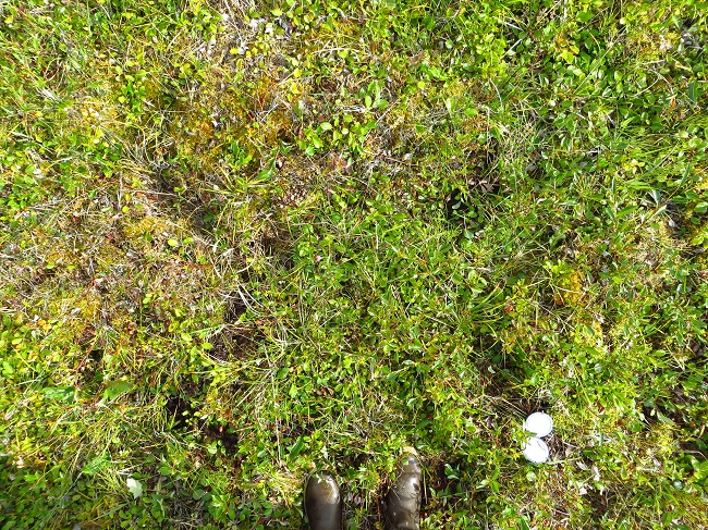
Figure 4. This is image # 0449 taken at the 'Imnavait' area along Imnavait Creek, roughly 10-km east of Toolik Lake, elevation 885.826 m.
Plant phenology, surface moisture, and lighting conditions vary. Efforts were made to keep the sun to the right-hand side of the photographer, to maintain semi-consistent shadow direction. No consistent length scale or color reference are included in the photos; however, in some photos a 2-m folding measuring stick is included, folded at 90 degrees to create a 1-m x 1-m corner. A small circular white reference ~6-cm in diameter (covered in white duct tape) is frequently included. The photographer's boots are also often visible.
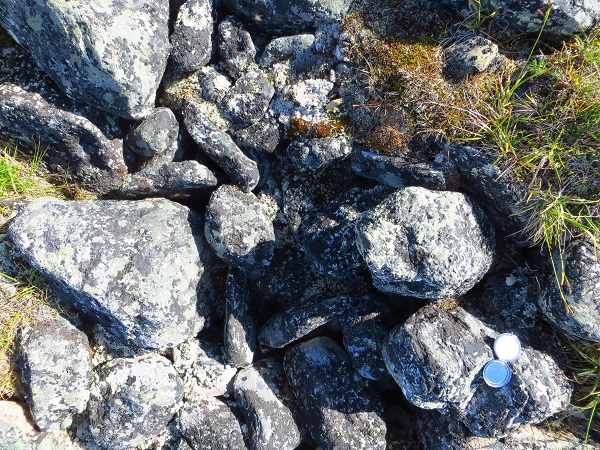
Figure 5. This is image # 0246 taken at the highest plot elevation of 972.585 m in the 'Pipeline' area, a stretch of the Trans-Alaska Pipeline. Elevation range was 717. 843 to 972.585 m.
Surfaces and vegetation are clearly visible and vascular plants can generally be identified to species or genus. Each plot photo was visually examined and assigned to a plant community that best described the plants in the center of the photo where GNSS coordinates had been measured. Refer to the Greaves et al. (2019) dataset for details regarding the related vegetation classification map.
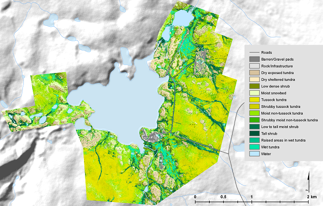
Figure 6. Vegetation classification map from the related dataset, Greaves et al. (2019) at https://doi.org/10.3334/ORNLDAAC/1690.
Data Access
These data are available through the Oak Ridge National Laboratory (ORNL) Distributed Active Archive Center (DAAC).
Ground-Based Vegetation Community Photos, Toolik Lake Area, Alaska, 2014-2015
Contact for Data Center Access Information:
- E-mail: uso@daac.ornl.gov
- Telephone: +1 (865) 241-3952
References
Heather Greaves, Jan Eitel, Lee Vierling, Natalie Boelman, Kevin L Griffin, Troy S Magney and Case M Prager. 2019. 20 cm resolution mapping of tundra vegetation communities provides an ecological baseline for important research areas in a changing Arctic environment. Environmental Research Communications. https://doi.org/10.1088/2515-7620/ab4a85.
Greaves, H.E., J. Eitel, L. Vierling, N. Boelman, K. Griffin, T. Magney, and C. Prager. 2019. High-Resolution Vegetation Community Maps, Toolik Lake Area, Alaska, 2013-2015. ORNL DAAC, Oak Ridge, Tennessee, USA. https://doi.org/10.3334/ORNLDAAC/1690
Greaves, H.E., L. Vierling, J. Eitel, N. Boelman, T. Magney, C. Prager, and K. Griffin. 2018. High-Resolution Shrub Biomass and Uncertainty Maps, Toolik Lake Area, Alaska, 2013. ORNL DAAC, Oak Ridge, Tennessee, USA. https://doi.org/10.3334/ORNLDAAC/1573