Documentation Revision Date: 2025-07-28
Dataset Version: 1
Summary
This dataset holds ten files in cloud optimized GeoTIFF format.
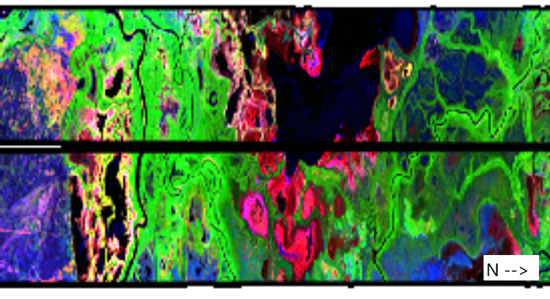
Figure 1. A color composite of double bounce scatter (red), volume scatter (green), and odd scatter (blue) derived from the polarimetric decomposition of data from a portion of two UAVSAR flight lines (padelW_18035 and padelE_36000) from June 13, 2017. Location is the vicinity of Mamawi Lake in Peace-Athabasca Delta in Alberta, Canada; approximately 58.581 latitude, -111.363 longitude.
Citation
Chapman, B., and N.H.F. French. 2025. UAVSAR Polarimetric Products for ABoVE Wetland Sites, Peace-Athabasca Delta, Canada. ORNL DAAC, Oak Ridge, Tennessee, USA. https://doi.org/10.3334/ORNLDAAC/2442
Table of Contents
- Dataset Overview
- Data Characteristics
- Application and Derivation
- Quality Assessment
- Data Acquisition, Materials, and Methods
- Data Access
- References
Dataset Overview
This dataset holds UAVSAR imagery products for the Peace-Athabasca Delta region of Canada. UAVSAR data were collected for two flight lines on five dates from 2017 to 2022 and processed to NISAR-like products with spatial resolution of approximately 10 m. Products include double bounce, volume, odd, and helical scatter components. In addition, radiometrically terrain corrected HH backscatter, HV backscatter, and the ratio of HH to HV, as well as the local incidence angle in radians and a valid data mask are provided. These data can be used to estimate the extent of inundation of wetlands in this region.
Project: ABoVE
The Arctic-Boreal Vulnerability Experiment (ABoVE) is a NASA Terrestrial Ecology Program field campaign being conducted in Alaska and western Canada, for 8 to 10 years, starting in 2015. Research for ABoVE links field-based, process-level studies with geospatial data products derived from airborne and satellite sensors, providing a foundation for improving the analysis, and modeling capabilities needed to understand and predict ecosystem responses to, and societal implications of, climate change in the Arctic and Boreal regions.
Acknowledgement:
This project was supported by the NASA ABoVE program (grant 80NM0018F0590).
Data Characteristics
Spatial Coverage: Peace-Athabasca Delta region of Alberta, Canada
Spatial Resolution: 0.0002 x 0.0001 degrees (~10 m)
Temporal Coverage: 2017-06-13 to 2022-08-16
Temporal Resolution: five one-time samples for each of two flight lines
Site Boundaries: Latitude and longitude are given in decimal degrees.
| Site | Westernmost Longitude | Easternmost Longitude | Northernmost Latitude | Southernmost Latitude |
|---|---|---|---|---|
| Peace-Athabasca Delta region, Alberta, Canada | -111.6085 | -111.1715 | 59.4366 | 57.5913 |
Data File Information
This dataset holds ten files in cloud optimized GeoTIFF format (Table 1).
The file naming convention is <study area>_<flight line>_<YY><num>_pol_cog.tif, where
- <study area> = “padelE” or “padelW” (the east or west flight paths)
- <flight line> = UAVSAR flight line ID (5 characters)
- <YY> = two digit year of flight (e.g., “17”, “18”, “22”)
- <num> = flight number (3 digits)
- “pol_cog.tif” indicates polarimetric products in cloud optimized GeoTIFF format.
GeoTIFF characteristics
- Coordinate system: geographic coordinates using WGS 84 datum, EPSG: 4326
- Spatial resolution: 0.0002 degrees longitude x 0.0001 degrees latitude (~10 m)
- Number of bands: 9 (see Table 2)
- Data type: Float32
- Additional metadata are encoded in the header of each GeoTIFF.
Table 1. GeoTIFF names and time at start of imagery aquisition.
| File name | Date time |
|---|---|
| padelE_36000_17062_pol_cog.tif | 2017-06-13 22:36:43 |
| padelE_36000_17093_pol_cog.tif | 2017-09-08 19:25:25 |
| padelE_36000_18047_pol_cog.tif | 2018-08-21 17:03:25 |
| padelE_36000_19059_pol_cog.tif | 2019-09-04 19:46:09 |
| padelE_36000_22032_pol_cog.tif | 2022-08-15 16:12:53 |
| padelE_36000_22033_pol_cog.tif | 2022-08-16 18:00:38 |
| padelW_18035_17062_pol_cog.tif | 2017-06-13 22:58:59 |
| padelW_18035_17093_pol_cog.tif | 2017-09-08 19:48:00 |
| padelW_18035_18047_pol_cog.tif | 2018-08-21 17:31:15 |
| padelW_18035_22033_pol_cog.tif | 2022-08-16 17:37:58 |
Table 2. Bands in GeoTIFFs. The units for bands 1-7 are linear radar power (amplitude).
| Band | Units | Description |
|---|---|---|
| 1 | 1 | Double bounce scatter |
| 2 | 1 | Volume scatter |
| 3 | 1 | Odd scatter |
| 4 | 1 | Helical scatter |
| 5 | 1 | HH radiometric terrain correction (RTC) factor |
| 6 | 1 | HV RTC |
| 7 | 1 | HH / HV |
| 8 | radians | Local incidence angle |
| 9 | - | Data mask: 0=no data, 1=valid data, 2=invalid data |
Application and Derivation
These data can be used to estimate inundation extent in wetland areas at the time of data acquisition.
Quality Assessment
Polarimetric calibration was applied to UAVSAR data (Fore et al., 2015).
Data Acquisition, Materials, and Methods
These UAVSAR datasets were acquired as part of NASA's Arctic Boreal Vulnerability Experiment (ABoVE). These data are from an airborne sensor, NASA's Uninhabited Aerial Vehicle Synthetic Aperture Radar (UAVSAR), an L-band radar instrument. The UAVSAR was deployed on a Gulfstream III aircraft in 2017, 2018, 2019, and 2022 (Table 2) that flew two parallel north-south flight lines over the Peace-Athabasca Delta in Alberta, Canada (Figure 2).
The GeoTIFFs were created by using ESA's Polsarpro software (https://earth.esa.int/eogateway/tools/polsarpro) to perform the Yamaguchi 4 component polarimetric decomposition of the fully polarimetric L-band SAR data. The GeoTIFFs hold the output products in separate bands: Double Bounce, Volume, Odd, and Helical scatter components in linear radar power (amplitude) units. Products also include radiometrically terrain corrected HH, HV backscatter, and the ratio of HH to HV, as well as the local incidence angle in radians and a valid data mask (Table 1). These datasets can be used to estimate inundation extent of wetlands in the study area.
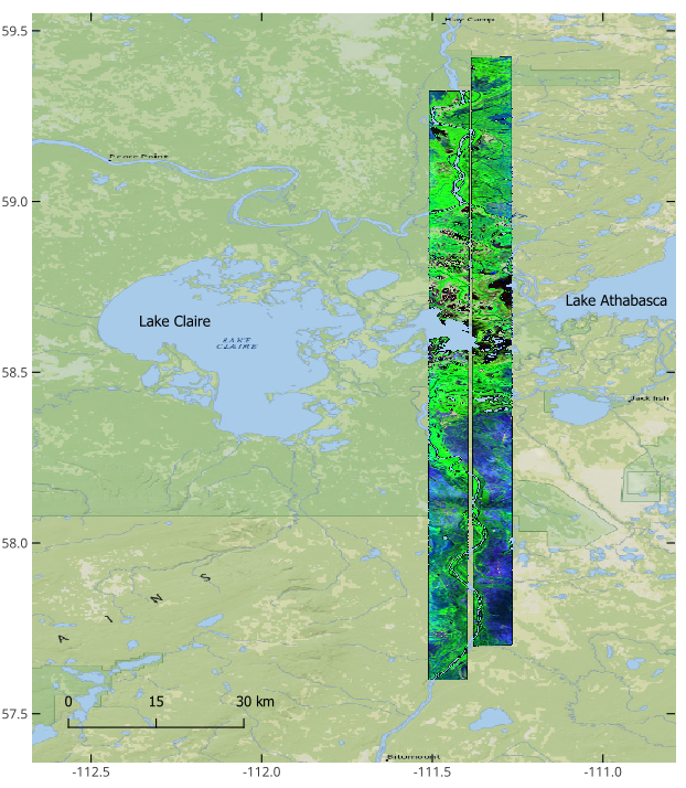
Figure 2. Two parallel UAVSAR flight lines over the Peace-Athabasca Delta region in Alberta, Canada, flown on August 16, 2022. Source: padelW_18035_22033_pol_cog.tif and padelE_36000_22033_pol_cog.tif. Basemap: © OpenStreetMap contributors.
Data Access
These data are available through the Oak Ridge National Laboratory (ORNL) Distributed Active Archive Center (DAAC).
UAVSAR Polarimetric Products for ABoVE Wetland Sites, Peace-Athabasca Delta, Canada
Contact for Data Center Access Information:
- E-mail: uso@daac.ornl.gov
- Telephone: +1 (865) 241-3952
References
Fore, A.G., B.D. Chapman, B.P. Hawkins, S. Hensley, C.E. Jones, T.R. Michel, and R.J. Muellerschoen. 2015. UAVSAR Polarimetric Calibration. IEEE Transactions on Geoscience and Remote Sensing 53:3481–3491. http://doi.org/10.1109/TGRS.2014.2377637