Documentation Revision Date: 2018-12-31
Data Set Version: 1
Summary
The study area includes the western boundary of the Upper Kuparuk River region and encloses a 20-km2 area surrounding Toolik Lake that stretches from the Dalton Highway on the east to Jade Mountain on the west. This includes the 1.2-km2 research grid on the south side of Toolik Lake, the old Toolik Lake pipeline construction camp gravel pad and airstrip on the northeast side of the lake and the primary terrestrial research areas on the south, west and east sides of the lake, as well as several smaller research lakes in the immediate vicinity of Toolik Lake. The Toolik Lake grid was constructed in 1989 to provide geographic referencing for experimental plots and to provide a sampling scheme for periodic measurements of snow, active layer and plant communities. Vegetation and environmental characteristics surrounding the Toolik Lake study plots were examined in August, 1989. Photography (1:5,000 scale base) for the vegetation maps in this data set was acquired in 1990.
There are four compressed shapefiles (*.zip) with this data set. The shapefile data are also provided as companion files in .kmz format for viewing in Google Earth.
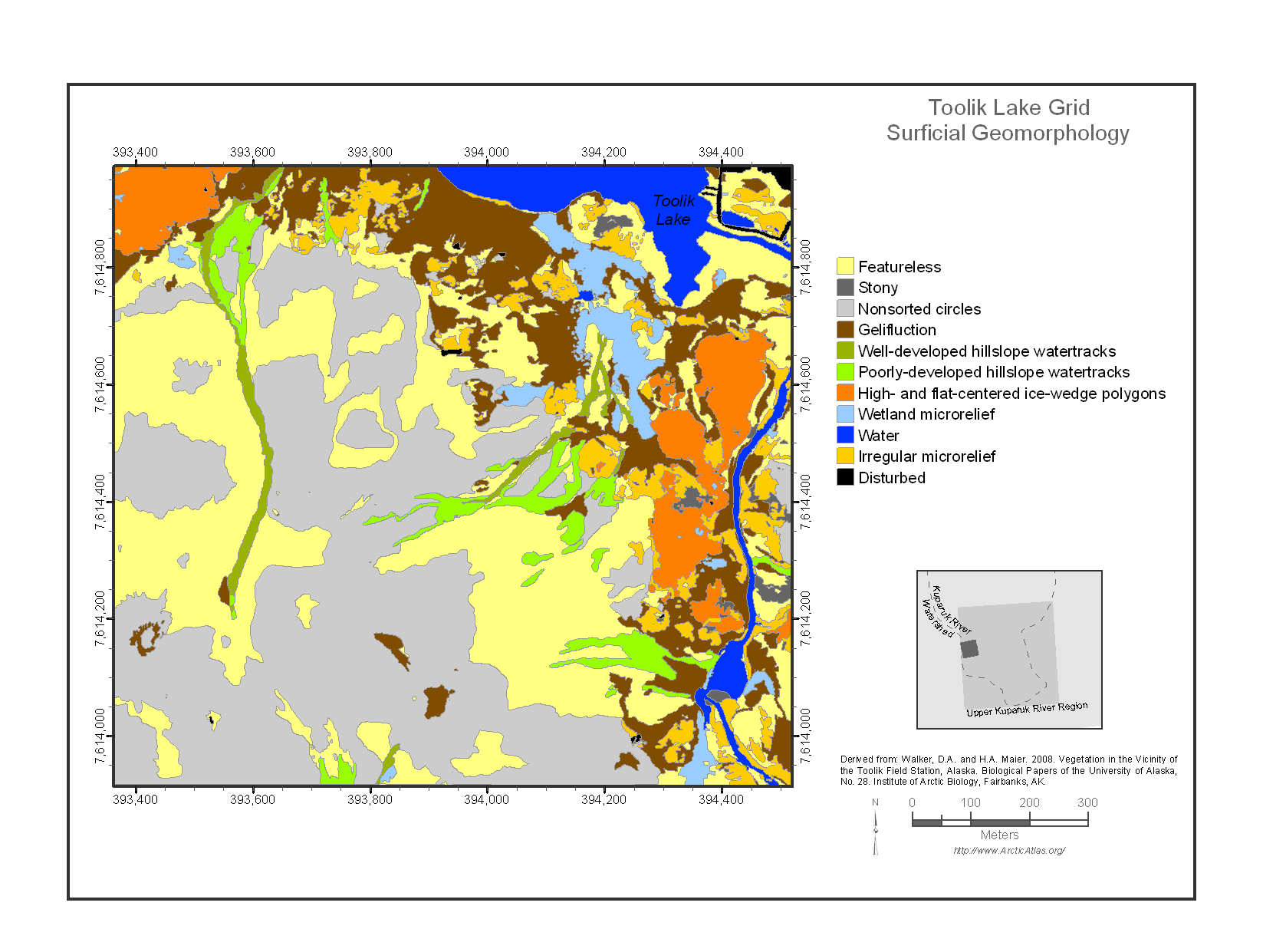
Figure 1. The Toolik Lake Grid Surficial Geomorphology map (Walker and Maier, 2008).
Citation
Walker, D.A. 2018. Maps of Vegetation Types and Physiographic Features, Toolik Lake Area, Alaska. ORNL DAAC, Oak Ridge, Tennessee, USA. https://doi.org/10.3334/ORNLDAAC/1380
Table of Contents
- Data Set Overview
- Data Characteristics
- Application and Derivation
- Quality Assessment
- Data Acquisition, Materials, and Methods
- Data Access
- References
Data Set Overview
This data set provides the spatial distributions of vegetation types, soil carbon, and physiographic features of the Toolik Lake area, North Slope, Alaska. Specific attributes include vegetation, percent water, glacial geology, soil carbon, a digital elevation model (DEM), surficial geology and surficial geomorphology.
The study area includes the western boundary of the Upper Kuparuk River region and encloses a 20-km2 area surrounding Toolik Lake that stretches from the Dalton Highway on the east to Jade Mountain on the west. This includes the 1.2-km2 research grid on the south side of Toolik Lake, the old Toolik Lake pipeline construction camp gravel pad and airstrip on the northeast side of the lake and the primary terrestrial research areas on the south, west and east sides of the lake, as well as several smaller research lakes in the immediate vicinity of Toolik Lake. The Toolik Lake grid was constructed in 1989 to provide geographic referencing for experimental plots and to provide a sampling scheme for periodic measurements of snow, active layer and plant communities.
Vegetation and environmental characteristics surrounding the Toolik Lake study plots were examined in August, 1989. Photography (1:5,000 scale base) for the vegetation maps in this data set was acquired in 1990. These data and others from nearby study areas were used in subsequent data sets, publications and maps (Shippert et al., 1995, Walker, 2016; Walker et al., 2014; Walker and Maier, 2008; Walker et al., 1995). See the related data set below (Walker, 2016) for more information.
Project: Arctic-Boreal Vulnerability Experiment (ABoVE)
The Arctic-Boreal Vulnerability Experiment (ABoVE) is a NASA Terrestrial Ecology Program field campaign that will take place in Alaska and western Canada between 2016 and 2021. Climate change in the Arctic and Boreal region is unfolding faster than anywhere else on Earth. ABoVE seeks a better understanding of the vulnerability and resilience of ecosystems and society to this changing environment.
Related Data Set
Walker, D.A. 2016. Pre-ABoVE: Arctic Vegetation Plots at Toolik Lake, Alaska, 1989. ORNL DAAC, Oak Ridge, Tennessee, USA. http://doi.org/10.3334/ORNLDAAC/1333
Acknowledgements:
These data were obtained from the Alaska Arctic Geoecological Atlas (http://agc.portal.gina.alaska.edu), which provides access to existing Arctic vegetation plot and map data in support of the ABoVE campaign.
Data Characteristics
Spatial Coverage: Area surrounding Toolik Lake, Alaska
ABoVE Site Designation:
Domain: Core ABoVE region
State/territory: Alaska
Grid cell: Ahh1Avv0
Spatial Resolution: 10 m
Temporal Coverage: 19900101 to 20140831
Temporal Resolution: One time mapping
Study Area: (all latitudes and longitudes given in decimal degrees)
| Site | West | East | North | South |
|---|---|---|---|---|
| Toolik Lake area, North Slope, Alaska | -149.669849 | -149.545711 | 68.656059 | 68.6169 |
Data file information
There are four compressed shapefiles (*.zip) with this data set. The shapefile data are also provided as companion files in .kmz format for viewing in Google Earth.
Table 1. File names and descriptions
| Data File names | Description |
|---|---|
| (1) aga_toolik_area_geobotanical_walker_2008.zip | Shapefile compressed into a zip file. The file provides the spatial distributions of vegetation types, soil carbon, and physiographic features of the Toolik Lake area |
| (2) aga_toolik_grid_geobotanical_walker_2008.zip | Shapefile compressed into a zip file. The file provides a gridded reference of the vegetation types, soil carbon, and physiographic features of the Toolik Lake area, as well as a DEM |
| (3) aga_toolik_area_veg_plot_washers_buchhorn_2014.zip | Shapefile compressed into a zip file. Elevation and GIS locations of the four washers defining the 1 x 1-m vegetation plots at these points |
| (4) aga_toolik_grid_points_buchhorn_2014.zip | Shapefile compressed into a zip file. Elevation and GIS locations of the 100-m spaced survey points |
| Companion files | Description |
| aga_toolik_area_geobotanical_walker_2008.kmz | The shapefile data from file #1 provided in .kmz format for viewing in Google Earth |
| aga_toolik_grid_geobotanical_walker_2008.kmz | The shapefile data from file #2 provided in .kmz format for viewing in Google Earth |
| aga_toolik_area_veg_plot_washers_buchhorn_2014.kmz | The shapefile data from file #3 provided in .kmz format for viewing in Google Earth |
| aga_toolik_grid_points_buchhorn_2014.kmz | The shapefile data from file #4 provided in .kmz format for viewing in Google Earth |
| Toolik_Lake_Area_Veg_Maps.pdf | This data set documentation in pdf format |
Table 2: Attributes in shapefiles 1 and 2 above (Table 1). Codes and descriptions are provided in Section 5
| Attributes | Description |
|---|---|
| PRI_VEG | Primary vegetation type |
| SEC_VEG | Secondary vegetation type |
| TER_VEG | Tertiary vegetation type |
| PERCENT_WA |
Percent Water: |
| PRI_SGEOM | Primary surficial geomorphology |
| SEC_SGEOM | Secondary surficial geomorphology |
| PRI_SGEOL | Primary surficial geology |
| SEC_SGEOL | Secondary surficial geology |
| GLAC_GEOL |
Glacial geology |
| SOIL_CARBO (this attribute is not in the Toolik grid shapefile) | Soil carbon. Values reflect the percentage. Values of 999 are no data |
| DEM (this attribute is only in the Toolik grid shapefile) | Digital Elevation Model |
Table 3: Attributes in shapefiles 3 and 4 above (Table 1).
| Attributes | Description |
|---|---|
| Name | Washer name in file 3. Study grid point name in file 4 |
| Northing | Projected latitude |
| Easting | Projected longitude |
| Elevation | Units in meters |
Table 3: Extent of the shapefiles
| File Name | West | East | North | South |
|---|---|---|---|---|
| aga_toolik_area_geobotanical_walker_2008.zip | -149.669849 | -149.545711 | 68.656059 | 68.609594 |
| aga_toolik_grid_geobotanical_walker_2008.zip | -149.622562 | -149.593044 | 68.626765 | 68.6169 |
| aga_toolik_area_veg_plot_washers_buchhorn_2014.zip | -149.619455 | -149.598771 | 68.626235 | 68.618006 |
| aga_toolik_grid_points_buchhorn_2014.zip | -149.621995 | -149.593827 | 68.627139 | 68.617092 |
Application and Derivation
These data could be useful as a historical baseline for climate change studies in the local region or as model validation data.
Quality Assessment
The maps were produced from several sources. Refer to the related publications for additional details regarding the individual maps.
Data Acquisition, Materials, and Methods
Site description
The Toolik Lake study area is located near the western boundary of the Upper Kuparuk River region and encloses a 20-km2 area surrounding Toolik Lake that stretches from the Dalton Highway on the east to Jade Mountain on the west. It includes the 1.2-km2 research grid on the south side of Toolik Lake, one of the principal intensive research areas at the Toolik Lake Field Station, the old Toolik Lake pipeline construction camp gravel pad and airstrip on the northeast side of the lake and the primary terrestrial research areas on the south, west and east sides of the lake, as well as several smaller research lakes in the immediate vicinity of Toolik Lake. The area contains surfaces with irregular topography that were glaciated during the Late Pleistocene.
The Toolik Lake grid was constructed in 1989 to provide geographic referencing for experimental plots and to provide a sampling scheme for periodic measurements of snow, active layer and plant communities.
Data Attribute Descriptions
The data provided in the shapefiles with this data set include attributes from individual maps, including gridded maps, of the Toolik Lake area. These attributes are described below and include vegetation, percent water, glacial geology, soil carbon, DEM, and surficial geology and geomorphology. The Toolik Lake grid data focuses on the south side of Toolik Lake. Unless otherwise noted, the attributes are in both files.
The shapefiles aga_toolik_area_veg_plot_washers_buchhorn_2014.zip and aga_toolik_grid_points_buchhorn_2014.zip provide only coordinate and elevation data; there is no additional information regarding those attributes.
Vegetation and environmental characteristics surrounding the Toolik Lake study plots were examined in August 1989. Photography (1:5,000 scale base) for the vegetation maps was acquired in 1990. These data and others from near-by study areas were used in subsequent data sets, publications, and maps (Shippert et al., 1995, Walker, 2016; Walker et al., 2014; Walker and Maier, 2008; Walker et al., 1995).
Vegetation
The vegetation data includes the physiognomy of the dominant plant communities. Forty-seven landcover types were recognized in the field (minimum mapping unit approximately 250 m2).
Table 4. Codes and descriptions used for PRI_VEG, SEC_VEG, and TER_VEG attributes.
| Code | Vegetation Units |
|---|---|
| 0 | < 30% of a secondary or tertiary vegetation unit type (SEC_VEG and TER_VEG attributes only) |
| 4 | Fen complex |
| 5 | Riparian shrublands |
| 6 | Water |
| 11 | Barren rocks |
| 12 | Lichen covered siliceous rocks (community type Cetraria nigricans-Rhizocarpon geographicum |
| 15 | Partially vegetated non-sorted circles (community type Anthelia juratzkana-Juncus biglumis |
| 21 | Dry areas with acidic soils (pH < 5.0) dominated by prostrate and dwarf shrubs (Arctous alpina, Betula nana, Cassiope tetragona, Dryas octopetela, Ledum decumbens, Salix phlebophylla, Vaccinium vitis-idaea, V. uliginosum), and fruticose lichens (Bryocaulon divergens, Cladina spp., Cetraria spp., Thamnolia spp.) Bryophytes (Polytrichum piliferum, Dicranum elongatum) are not abundant. Typically found on dry glacial till and outwash deposits, steep south facing slopes, and alpine areas in the mountains. |
| 22 | Areas on nonacidic soils (pH > 5.0) dominated by Dryas integrifolia, other dwarf and prostrate shrubs (e.g. Salix arctica, S. reticulata), mat and cushion plants (Saxifraga oppositifolia, Oxytropis bryophila and lichens (Lecanora epibryon, Cetraria spp.) Bryophytes (Ditrichum flexicaule, Distichium capillaceum) are not abundant. Includes vegetation on nonacidic stripes (community type Astragalus umbellatus-Dryas integrifolia) |
| 23 | Areas dominated by Cassiope tetragona, and other dwarf shrubs (Ledum decumbens and Diapensia lapponica in acidic sites and Dryas integrifolia, Salix reticulata and S. rotundifolia in nonacidic sites) and fruticose lichens (Cladina spp. Cetraria spp., Nephroma arctica). Usually with significant components of bryophytes (Hylocomium splendens, Tomentypnum nitens) and the conspicuous forbs Boykinia richardsonii and Novosieversia glacialis. |
| 24 | Well-drained slopes and terraces (community type Oxytropis bryophila-Dryas integrifolia) often with significant inclusions of moist nonacidic tundra (Assoc. Dryado integrifolia-Caricetum bigelowii Walker et al. 1994, code 321 |
| 31 | Moist acidic tundra complex |
| 32 | Moist nonacidic tundra complex |
| 41 | Poor fen complex, wetland areas with dysic organic soils (pH < 4.5) and dominated by sedges (Carex rariflora, C. rotundata, Eriophorum scheuchzeri) and mosses (mainly Sphagnum spp.). |
| 41 | Wetland areas with euic organic soils (pH > 4.5) dominated by sedges (Carex chordorrhiza, Carex aquatilis, Eriophorum angustifolium) and mosses (mainly Drepanocladus spp., Scorpidium scorpioides, Tomentypnum nitens). Wet sites have rich fen communities (e.g. community types Carex aquatilis-Carex chordorrhiza and Carex aquatilis-Eriophorum angustifolium) |
| 42 | Rich fen complex |
| 43 | Aquatic vegetation (community types Hippuris vulgaris-Arctophila fulva, and Hippuris vulgaris-Sparganium hyperboreum |
| 51 | Areas dominated by willows along watertracks, streams and rivers. |
| 52 | Dense shrub thickets on slopes and drainages dominated by Salix glauca and Alnus crispa |
| 131 | Partially vegetated limestone (community type Saxifraga oppositifolia-Saxifraga eschscholtzii |
| 141 | Barren and partially vegetated river alluvium (community type Epilobium latifolium-Castilleja caudata |
| 142 | Revegetated gravel mines and construction pads (community type Festuca rubra |
| 211 | Usually includes a mosaic of communities typical of windblown areas (Assoc. Selaginello sibiricae-Dryadetum octopetalae Walker et al. 1994) |
| 212 | and Assoc. Salici phlebophyllae-Arctoetum alpinae Walker et al. 1994 |
| 213 | Community type Hierochloe alpina-Betula nana |
| 214 | Vegetation on acidic nonsorted stripes (community type Calamagrostis inexpansa-Cassiope tetragona) |
| 215 | Also includes uncommon fruticose-lichen dominated areas (community type Cladina arbuscula-Stereocaulon tomentosum) |
| 231 | Usually with significant components of bryophytes (Hylocomium splendens, Tomentypnum nitens) and the conspicuous forbs Boykinia richardsonii and Novosieversia glacialis. Includes moderately deep acidic snowbeds (Assoc. Carici microchaetae-Cassiopetum tetragonae Walker et al. 1994) |
| 232 | Nonacidic snowbeds (community type Dryas integrifolia-Cassiope tetragona) |
| 233 | Communities of deep snowbeds (community type Salix rotundifolia) |
| 311 | Areas on acidic soils (pH < 5.0) dominated by tussock-sedges (Eriophorum vaginatum), nontussock sedges (Carex bigelowii), dwarf shrubs (Betula nana, Salix pulchra, Ledum decumbens, Vaccinium spp.) and mosses (Sphagnum spp, Hylocomium splendens, Aulocomnium turgidum). The dominant vegetation of most acidic hillslopes and moderately drained acidic sites. Includes tussock tundra and other graminoid dominated facies of Assoc. Sphagno-Eriophoretum vaginati Walker et al. 1994 |
| 312 | Betula nana shrublands in basin wetlands and marginal to watertracks |
| 321 | Areas on nonacidic soils (pH > 5.0) dominated by nontussock sedges (Carex bigelowii, C. membranacea, Eriophorum triste), prostrate and dwarf shrubs (Dryas integrifolia, Rhododendron lapponicum, Salix arctica, S. reticulata, S. lanata), and mosses (Tomentypnum nitens, Hylocomium splendens, Aulacomnium turgidum). The dominant vegetation of most nonacidic hillslopes. Includes all facies of Assoc. Dryado integrifolia-Caricetum bigelowii Walker et al. 1994 |
| 322 | Snowbed subassociations and facies of Dryado integrifolia-Caricetum bigelowii Walker et al. 1994 |
| 324 | Areas with open canopies of low-shrubs (Salix lanata, Salix glauca, Alnus crispa) includes rich communities found in a few drained lake basins on glacial outwash surfaces (community type Deschampsia caespitosa- Carex saxatilis) |
| 411 | Raised microsites are consistently acidic with Sphagnum-rich communities (community type Sphagnum lenense-Salix fuscescens) |
| 412 | Relatively acidic poor fen complex (community type Sphagnum orientale-Eriophorum scheuchzeri) |
| 413 | Relatively acidic poor fen complex (community type Carex aquatilis-Sphagnum spp.) |
| 421 | Raised microsites are consistently nonacidic (e.g. community type Tomentypnum nitens-Trichophorum caespitosum) |
| 511 | Willow communities in water tracks (community type Eriophorum angustifolium-Salix pulchra |
| 512 | Willow communities along larger streams (community types Salix alaxensis-Salix richardsonii spp. Lanata) |
| 513 | shrub communities along larger streams (community types Betula nana) |
| 514 | willow communities along larger streams (community type Salix pulchra-Calamagrostis canadensis) |
| 515 | Shrublands are usually mixed with significant components of graminoid and forb dominated areas (e.g; community type Carex podocarpa-Dodecatheon frigidus, code 515 |
| 3111 | Areas on acidic soils (pH < 5.0) dominated by tussock-sedges (Eriophorum vaginatum), nontussock sedges (Carex bigelowii), dwarf shrubs (Betula nana, Salix pulchra, Ledum decumbens, Vaccinium spp.) and mosses (Sphagnum spp, Hylocomium splendens, Aulocomnium turgidum). The dominant vegetation of most acidic hillslopes and moderately drained acidic sites. Includes tussock tundra and other graminoid dominated facies of Assoc. Sphagno-Eriophoretum vaginati Walker et al. 1994 |
| 3112 | Poorly developed water tracks (shrub facies of Sphagno-Eriophoretum vaginati Walker et al. 1994 |
| 3113 | Sphagno-Eriophoretum vaginati Walker et al. 1994 |
| 5121 | Most shrubs are less than 1 m tall, but along the larger streams, the willows may exceed 2-3 |
Percent Water
The amount of water (lakes, ponds, streams, wetlands), strongly affects the reflectance of the land surface over large areas of Alaska. For both the Toolik Lake and Toolik Lake grid data, the percent water was based on the number of AVHRR water pixels in each polygon divided by the number of pixels in each polygon. The classes of water coverage in a polygon were reported as follows: 0%, 1-5%, 5-25%, 25-50%, 50-75%, 75-90%, 90-100%.
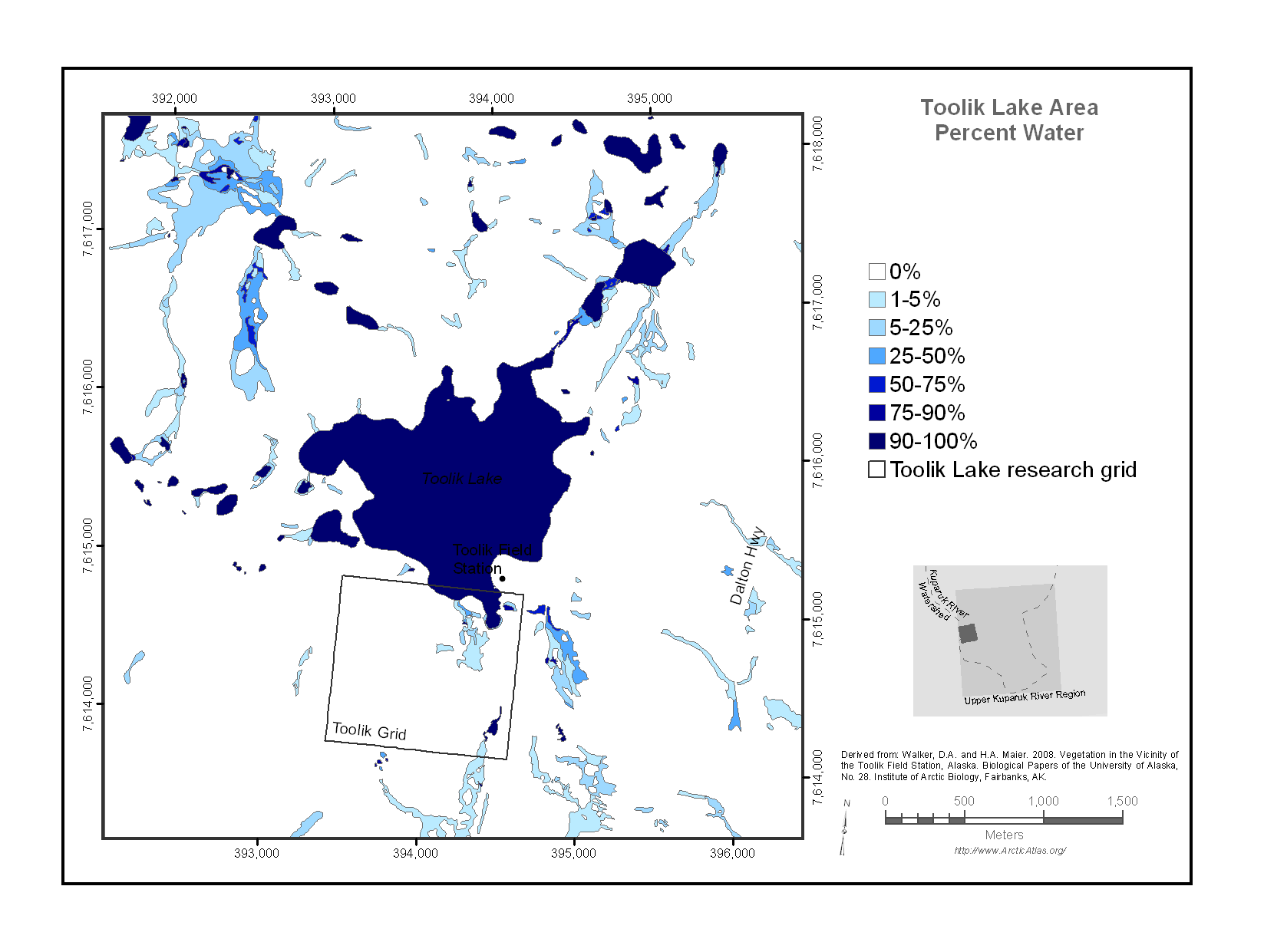
Figure 2. The Toolik Lake Area Percent Water Map (Walker et al., 2008).
Glacial Geology
The glacial geology of the region affects a wide variety of landscape and ecosystem properties including topography, abundance of lakes, plant production, soil carbon, spectral reflectance, biodiversity, trace-gas fluxes and heat flux of the landscape. Glacial deposits within the Toolik Lake area are assigned to Itkillik I (late Pleistocene, about 120-150 kya) and Itkillik II (late Pleistocene, about 25-11.5 kya) glaciations of the central Brooks Range glacial succession.
Soil Carbon (this attribute is not in the Toolik grid shapefile)
The soil carbon content in the Toolik Lake area was extrapolated from soil samples collected from different vegetation types. Values were reported ranging from <5 kg C / m2 to > 45 kg C / m2. Methods can be found in Walker & Barry 1991.
DEM (this attribute is only in the Toolik grid shapefile)
This Digital Elevation Model was created from the contour lines of the Aerometrics orthophoto from 1996. In addition the 1 x 1-km Circumpolar Active Layer Monitoring (CALM) grid with 121 points (every 100 m) was resurveyed in summer 2014 with a Topcon Real Time Kinematic (RTK). This RTK data as well as a lake and river layer were included in the DEM creation. The DEM accuracy is +/- 1 m. A contour shapefile was created from the DEM, and is available for download.
Surficial Geology
Surficial geology affects vegetation patterns and disturbance recovery rates. The most common units on the Toolik Lake Area map are colluvial deposits, with some glacio-fluvial, organic, and other types of surface deposits.
Table 5. Surficial geology features were grouped into the following units, with respective codes and descriptions for the PRI_SGEOL and SEC_SGEOL attributes.
| Code | Surficial Geology Units | Surficial Geology Unit Description |
|---|---|---|
| 1 | Glacial till deposit | Glacial till in the region was deposited during the Sagavanirktok and Itkillik glaciations (mid and late Pleistocene). Till surfaces are generally rocky and gently undulating with blockfields, and nonsorted circles. Till on most surfaces has been covered by fine-grained colluvium that has been transported from upslope. |
| 2 | Glaciofluvial deposit | Outwash deposited by meltwaters from the Pleistocene glaciers. Glaciofluvial deposits cover large areas marginal to many modern floodplains. Outwash deposits have irregular, rocky microrelief with a wide variety of landforms including kames, kame terraces, and flat terraces with high-centered polygons. |
| 3 | Other alluvial deposits | Stream deposits occur on modern and ancient floodplains, watertracks, and alluvial fans |
| 4 | Colluvial deposit | Hillslope deposits whose origin is due primarily to downslope movement of material under the force of gravity, but often also in association with forces due to water movement. Colluvial materials often cover other deposits and bedrock. |
| 5 | Organic deposit | Organic deposits greater than 50 cm deep occur in colluvial basins and in some areas with wide watertracks |
| 6 | Lacustrine deposits | Lake sediments occur in association with drained glacial lakes such as Galbraith Lake and along the Sagavanirktok River, and a few much smaller drained glacial kettles and ponds. |
| 8 | Water | includes lakes, ponds and rivers |
| 9 | Disturbed | Includes all anthropogenic disturbances, such as gravel pads, gravel mines, and airstrips |
| 10 | Eolian deposit | Windblown fine sand and silt associated with drained lakes and loess from rivers |
| 71 | Bedrock - Lisburne Group Limestone | Lisburne limestone bedrock occurs in southeastern areas of the map |
| 72 | Bedrock - Kanyute Formation | Most bedrock is a mixture of sandstone and conglomerate typical of the Kanyute Formation |
Surficial Geomorphology
The surfaces of the landscapes in the Toolik Lake area have been modified by a variety of geomorphological processes including alluviation (movement of material by water), colluviation (movement of material by gravity), and periglacial processes (freezing and permafrost-related phenomena). Common surficial geomorphological features within the mapped area include sorted and nonsorted circles (frost boils), turf hummocks, gelifluction lobes and terraces, water tracks, high- and low-centered ice-wedge polygons, wetland features and thermokarst features.
Table 6. Surficial geomorphological features were grouped into the following units with respective Codes and Descriptions Used for PRI_SGEOM and SEC_SGEOM attributes.
| Code | Surficial Geomorphology Units | Surficial Geomorphology Unit Description |
|---|---|---|
| 0 | < 30% of a secondary geomorphology unit type | SEC_SGEOM attribute only |
| 1 | Nonsorted circles | Roughly circular 1-2-m diameter slightly convex barren features, spaced from 2 to many meters apart. They are composed of fine-grained mineral material that periodically undergo freezing and heaving. Nonsorted circles, or frost scars, are ubiquitous features on most hillslopes, and are not differentiated here unless they cover more than 50% of a surface. |
| 2 | Stripes | Hillslopes with a striped pattern consisting of elongated relatively dry well-drained elements 1-3 m wide oriented down the steepest available slope, alternating with intervening moister interstripe elements 1-3 m wide. They are caused by combination of cryoturbation, erosion, and gelifluction. The dry elements usually are covered by nonsorted circles. Most stripes are nonsorted with similar grain size of material in the stripe and interstripe areas; sorted stripes and circles occur in rocky alpine areas. |
| 3 | Upland turf hummocks | Small regularly spaced hummocks |
| 4 | Wetland microrelief | Wet areas with a mixture of strangmoor, disjunct ice-wedge polygon rims, aligned hummocks, nonaligned hummocks, and lowland watertracks. Strangmoor consists strangs, which are sinuous ridges many meters long that form perpendicular to the direction of the local hydrologic gradient. Aligned hummocks are shorter features also oriented perpendicular to the hydrologic gradient. The strangs are up to 0.5 m wide and 0.5 high. Disjunct polygon rims are associated with incompletely formed or eroded low-centered polygons. |
| 5 | Gelifluction features | Areas of slow downslope movement of the active layer caused by saturated soils moving over permanently frozen ground. Includes gelifluction lobes, benches, and streams mostly greater than 50 cm high. Common on steep hillslopes. |
| 6 | High-centered ice-wedge polygons and palsas | Ice-wedge polygons with a raised center portion that is raised above the trough element. Relief between the center and the trough is normally about 0.5-1.0 m, and polygon diameters are usually 10-15 m in diameter. High centered polygons occur marginal to larger streams and rivers, especially on outwash terraces. On some upland surfaces, the polygons are poorly developed or totally masked by tussock-tundra vegetation. Some raised features, particularly in colluvial palsas, which are small peaty mounds with perennial ice lenses. |
| 7 | Low-centered ice-wedge polygons | Ice-wedge polygons composed of a central low "basin", a raised "rim", and a "trough" between polygons. The basins are usually 8-10 m in width and circular to weakly polygonal in plan. The raised rims of the polygons may be as much as 1-2 m wide, as much as 0.5 m higher than the basin and may compose over 30% of the total polygonal unit. The troughs of polygons occur over the tops of underlying ice wedges, are usually less than 1 m wide. The basins and troughs are usually wet all summer. Thermokarst ponds commonly occur at the junctions of polygon troughs. Low-centered polygons are not abundant in the region but occur in association with flat drained lake basins and river floodplains. pads. |
| 8 | Thermokarst land | Three situations: (1) Areas with eroding subsurface ice that may be buried glacial ice or ice-rich permafrost; this occurs marginal to several kettle lakes on Itkillik-age glacial surfaces. (2) Thermokarst pits that occur at ice-wedge junctions and often associated with ice-wedge polygons. (3) Beaded streams that have regularly spaced circular pools that have formed where the stream has eroded out ice-wedge junctions; between "beads" the stream often follows a linear channel along eroded ice-wedges. |
| 9 | Featureless | Areas with no discernible pattern at the mapping scale. However, nonsorted circles, small gelifluction features, and/or poorly-developed water tracks commonly occur in these areas. |
| 10 | Well-developed hillslope watertracks | Shallow subparallel drainages normally spaced tens of meters apart, with well-defined channels giving many slopes distinctive "horsetail" patterns. Well-developed watertracks carry runoff and meltwater through most of the summer and are usually filled with shrubby vegetation. They are most abundant on long lower hillslopes, particularly slopes that have deep snow accumulation to provide meltwater throughout the summer. |
| 11 | Poorly-developed hillslope watertracks | Watertracks with poorly defined channels that normally carry runoff only during the snowmelt season and immediately after rainfall events. They are discernible on aerial photographs because of somewhat shrubbier vegetation in the water tracks. Poorly defined watertracks often occur on upper hillslopes and may turn into well-developed watertracks on the lower slopes. |
| 12 | Irregular microrelief | This unit is used for a wide variety of situations where there is considerable microrelief that cannot be ascribed to any of the above features, such as rolling topography common on till and outwash surfaces, hillslopes and bluffs with irregular erosion features, and floodplains with a mixture of channels, bars, ponds, etc. |
| 13 | Stony surface | Areas covered by cobbles and stones such as river gravels. |
| 14 | Disturbed | Includes gravel mines and construction pads. |
| 15 | Water | Includes lakes, ponds, and rivers. |
| 16 | Thermokarst water | This code is used in three situations: (1) Areas with eroding subsurface ice that may be buried glacial ice or ice-rich permafrost; this occurs marginal to several kettle lakes on Itkillik-age glacial surfaces. (2) Thermokarst pits that occur at ice-wedge junctions and often associated with ice-wedge polygons. (3) Beaded streams that have regularly spaced circular pools that have formed where the stream has eroded out ice-wedge junctions; between "beads" the stream often follows a linear channel along eroded ice-wedges. |
| 17 | Stony surface | Areas covered by talus slopes, blockfields, and bedrock areas. |
| 18 | Pond complex | Wetland areas with numerous ponds mixed with relatively well-drained areas. |
Data Access
These data are available through the Oak Ridge National Laboratory (ORNL) Distributed Active Archive Center (DAAC).
Maps of Vegetation Types and Physiographic Features, Toolik Lake Area, Alaska
Contact for Data Center Access Information:
- E-mail: uso@daac.ornl.gov
- Telephone: +1 (865) 241-3952
References
Shippert, M.M., D.A. Walker, N.A. Auerbach, and B.E. Lewis. 1995. Biomass and leaf-area index maps derived from SPOT images for Toolik Lake and Imnavait Creek areas, Alaska. Polar Record 31:147–154. https://doi.org/10.1017/S0032247400013644
Walker, D.A. 2016. Pre-ABoVE: Arctic Vegetation Plots at Toolik Lake, Alaska, 1989. ORNL DAAC, Oak Ridge, Tennessee, USA. http://doi.org/10.3334/ORNLDAAC/1333
Walker, D.A., T.D. Hamilton, H.A. Maier, C.A. Munger, and M.K. Raynolds. 2014. Glacial history and long-term ecology in the Toolik Lake region. Pages 61–80 in J. E. Hobbie and G. W. Kling, editors. Alaska's changing Arctic: Ecological consequences for tundra, streams, and lakes. Oxford, New York. http://doi.org/10.1093/acprof:osobl/9780199860401.003.0003
Walker, D.A. and H.A. Maier. 2008. Vegetation in the Vicinity of the Toolik Lake Field Station, Alaska. Biological papers of the University of Alaska, No. 28, Institute of Arctic Biology, University of Alaska, Fairbanks.
Walker, D.A., N.A. Auerbach, and M.M. Shippert. 1995. NDVI, biomass, and landscape evolution of glaciated terrain in northern Alaska. Polar Record 31:169–178. https://doi.org/10.1017/S003224740001367X
Walker, D.A. and N. Barry. 1991. Toolik Lake permanent vegetation plots: site factors, soil physical and chemical properties, plant species cover, photographs, and soil descriptions. Data Report, Department of Energy R4D Program, Institute of Arctic and Alpine Research, University of Colorado, Boulder, CO, USA.
Walker, M.D., D.A. Walker and N.A. Auerbach. 1994. Plant communities of a tussock tundra landscape in the Brooks Range Foothills, Alaska. Journal of Vegetation Science 5:843-866. http://www.jstor.org/stable/3236198